Browse Listings
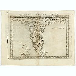
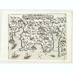
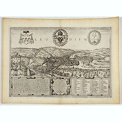
Calecut Nuova Tavola.
Early map of India, extending from west of the Gujarat peninsula eastward to Bengal and south as far as northern Ceylon (“Ceilam”). Girolamo Ruscelli first published ...
Date: Venice, 1564
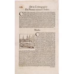
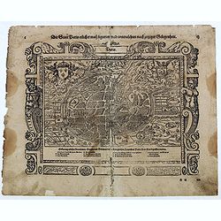
Meche.
Panoramic view of Mecca from Antoine du Pinet's "Plantz, Pourtraitz, Et descriptions De Plusieurs Villes". Woodblock print in text leaf with an interesting desc...
Date: Lyon, 1564
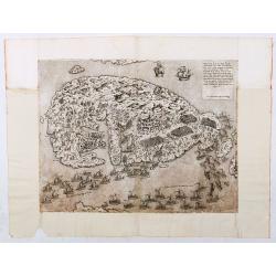
Malita
The map includes, at the top left, a text and imprint, and, in the lower left, a scale decorated with a compass.The second state of Antonio Lafreri's map of the island of...
Date: Rome, 1565
![[Two plates on one sheet] Ordinanza Turchesa alla presa di Zigeth in Ongaria l’anno 1566 / Ordinanza Turchesca sotto Viena, contra lo Invictißimo Imperatore Carlo quinto l'anno 1550.](/uploads/cache/49073-250x250.jpg)
[Two plates on one sheet] Ordinanza Turchesa alla presa di Zigeth in Ongaria l’anno 1566 / Ordinanza Turchesca sotto Viena, contra lo Invictißimo Imperatore Carlo quinto l'anno 1550.
Ordinanza Turchesca sotto Viena, contra lo Invictißimo Imperatore Carlo quinto l'anno 1550". C. 1560. This extremely rare plate depicts the order of battle and for...
Date: Venice, 1550/ 1566

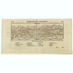
XII. Laurater Basler gelegenheit.
Very early wood cut printed regional map of Switzerland with Basel region.Originally engraved in 1548. The map was prepared by Johannes Stumpf (1500-1576). Included in &q...
Date: Zurich, Christoffel Froschover, 1548,1552-1566
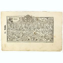
XI. Wallis.
Very early wood cut printed regional map of Switzerland with Wallis region.Originally engraved in 1548. The map was prepared by Johannes Stumpf (1500-1576). Included in &...
Date: Zurich, Christoffel Froschover, 1548,1552-1566

IX. Die Lepontier.
Very early wood cut printed regional map of Switzerland.Originally engraved in 1548. The map was prepared by Johannes Stumpf (1500-1576). Included in "Landtaflen. Hi...
Date: Zurich, Christoffel Froschover, 1548,1552-1566
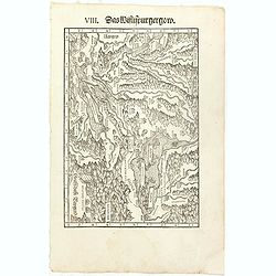
VIII. Das Wiflispurgergow.
Very early wood cut printed regional map of Switzerland with Lake Geneva.Originally engraved in 1548. The map was prepared by Johannes Stumpf (1500-1576). Included in &qu...
Date: Zurich, Christoffel Froschover, 1548,1552-1566

VII. Das Ergow.
Very early wood cut printed regional map of Switzerland centered on Ergow.Originally engraved in 1548. The map was prepared by Johannes Stumpf (1500-1576). Included in &q...
Date: Zurich, Christoffel Froschover, 1548,1552-1566

( II Germania) / Tütschland.
Very early wood cut printed map of Germany, Poland, The Low Countries, Alsace and part Europe with of Switzerland, Croatia. Originally engraved in 1548. Included in "...
Date: Zurich, Christoffel Froschover, 1548,1552-1566

I Europa / Das dritteil der Welt.
Very early wood cut printed map of Europe with South to the top. In the lower-left corner we see Poland, Livonia and parts of England and Ireland in the lower right corne...
Date: Zurich, Christoffel Froschover, 1548,1552-1566
DESCRIPTION DE TOUT LE PAIS BAS Autrement dict La Germanie Inferieure, ou Basse-Allemaigne…
First French edition. Illustrated with a coat of arms and portrait of Philips II, with a folding map of The Netherlands and maps and views of Brabant, Louvain, Brussel, A...
- $4500 / ≈ €3905
Date: Anvers. Guillaume Silvius, 1567
-250x250.jpg)
La descrittione di Belgica con le sve frontiere (maps of the Seventeen Provinces)
La descrittione di Belgica con le sve frontiere Omnis Belgica intra Rhenum, marronam, Sequana[m] ac Oceanum, ... This is one of the earliest printed maps of the Sev...
Date: Antwerp, 1567
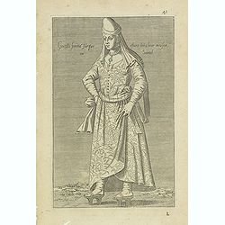
Gentille femmé Turque estant dans leur maison ou Sarail. (41)
Sought-after copper engraved plate from Laonikos Chalcocondyle’s "L'histoire de la décadence de l'empire grec et establissement de celuy des Turcs." by Thoma...
Date: Lyon, 1567
![IL GOLFO DI VENETIA [Gulf of Venice].](/uploads/cache/49393-250x250.jpg)
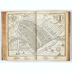
IL GOLFO DI VENETIA [Gulf of Venice].
IL GOLFO DI VENETI A si come è il più famose et jllustre di quanti sono dal Mare inondati, cosi dovendo uscire al mondo nelle mie stampe piu copioso di quanti fin hora ...
Date: Venice,1568
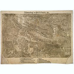
Orleans assiegé au mois de Janvier. 1563.
Rare copper engraved view of the siege of Orleans in January 1563, engraved by Jean Jacques Perrissin, (1536 - before 1611).Print from the suite "The Wars, Massacres...
- $100 / ≈ €87
Date: Geneva, ca. 1570
![[Title page for] Theatrum Orbis Terrarum.](/uploads/cache/47940-250x250.jpg)
[Title page for] Theatrum Orbis Terrarum.
A decorative title page of the first atlas ever made shows five female figures as allegorical representatives of the continents, grouped around the title. According to P...
Date: Antwerp, after 1570
![[Cairo] Wahrhafftige Abcontrafehtung der Mechtigen und Vesten Statt Alkair.](/uploads/cache/48618-250x250.jpg)
[Cairo] Wahrhafftige Abcontrafehtung der Mechtigen und Vesten Statt Alkair.
Double page 16th century woodblock city plan of Cairo. Bird's-eye perspective with amazing detail of the buildings, gardens, temples, palaces, farms and markets. Includes...
Date: Basel, ca. 1570
![[Euboe].](/uploads/cache/41989-250x250.jpg)
[Euboe].
Woodcut Ptolemaic-style map by Sebastian Münster figuring Euboea Island, published in the edition of Strabo by Henri Petri in 1571."Strabonis rerum geographicarum&q...
Date: Basle, Henri Petri, 1571
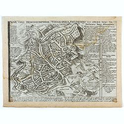
Novae Urbis Hierosolymitanae topographica delineatio . . .
A very rare plan of modern Jerusalem oriented to the east, according to a note on the map the map was drawn after a map by Peter Laicstain. A lettered key to the right.Up...
Date: Antwerp, 1571
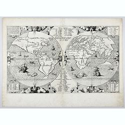
Benedict. Arias Montanus Sacrae Geographiae Tabulam Ex Antiq
THE EXTREMELY RARE FIRST STATE landmark world map, famed for its depiction of the Australian landmass.One of the earliest printed maps to depict the “terra incognita�...
Date: Anvers 1571 /1572
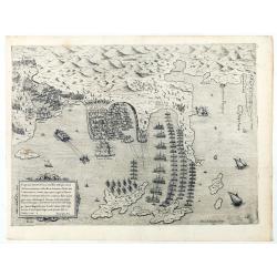
Disegno dove al presente si ritrova l'armata della santa legha contro la turchesca, nel promontorio della Morea dirincontro a Modon, dove l'armata nemica si è retirata… VI.Ottobre.1572.
Disegno dove al presente si ritrova l'armata della santa legha contro la Turchesca, nel promontorio della Morea dirincontro a Modon dove l'armata nemica si e retirata, lu...
Date: Rome, 1572
Damascus, urbs.
Early view of Damascus, a bird's eye view from the greatest publication in this genre ! The Civitates was compiled and written by George Braun, Canon of Cologne Cathedral...
- $750 / ≈ €651
Date: Cologne, 1572
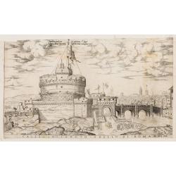
Castello Sancto Angelo di Roma.
The print features the Castello Sant' Angelo in Rome, bound in an album, perhaps from the "Speculum Romanae Magnificentiae." Copper engraving and published by A...
Date: Rome, Antonio Lafreri, ca. 1573
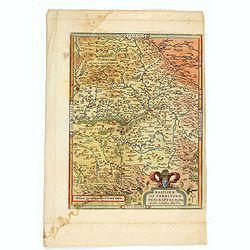
Basiliensis territorii descriptio nova.
Left hand map centered on Basle, east to top. With credit to Sebastian Münster in title cartouche.
- $200 / ≈ €174
Date: Antwerp, 1573
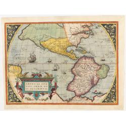
Americae Sive Novi Orbis, Nova Descriptio.
This is the second state of the first copperplate of Ortelius' map showing the western hemisphere, showing the prominent bulge in the South American coastline. The first,...
Date: Antwerp, 1573
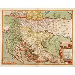
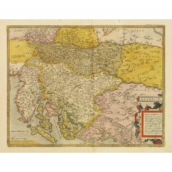
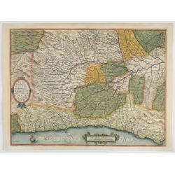
Illyricum.
Early map of Istria and Slovenia. Prepared by Johann Sambucus 1572.
Date: Antwerp, 1574
Die statt Montpellier . . .
Panoramic view of Montpellier by Sebastian Münster. Below the engraving a letterpress key. From the German edition of Sebastian Munster's Cosmography, "Cosmographey...
Date: Basel, Heinrich Petri, 1574
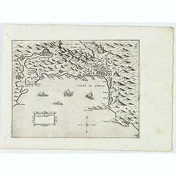
Golfo de Lodrin con parte di Albania.
Rare map of the northern coast of Albania, Serbia and Montenegro, extending from Malonta and Castel Novo and Bocca del Colfo di Cattaro to Durrës. Venetian war ships in ...
- $1500 / ≈ €1302
Date: Venice, D.Bertelli, ca.1574
Sebenico antiquam.e Sico detto Citta nobile nella prouincia della Dalmacia. . .
Uncommon map of the coast of Croatia with the bay and town of Šibenik (Sebenico) with Venetian war ships in the foreground. From Giovanni Francesco Camocio's rare "...
- $1000 / ≈ €868
Date: Venice, D.Bertelli, ca.1574
Trau citta nella Dalmacia vicino al Spaleto. . .
Uncommon map of the Dalmatian coast with the town of Trau (Trogir) in Croatia, from Giovanni Francesco Camocio's rare " Isole Famose porti, fortezze, e terre maritim...
- $1000 / ≈ €868
Date: Venice, D.Bertelli, ca.1574
Provincia Di Albania.
Uncommon map of Albania, from Giovanni Francesco Camocio's rare " Isole Famose porti, fortezze, e terre maritime . . ." The second state, includes the plate n...
- $1200 / ≈ €1041
Date: Venice, D.Bertelli, ca.1574

Franciae orientalis../ Monasteriensis et osnaburgensis..
From 'Theatrum Orbis Terrarum [Atlas of the Whole World]' published in Antwerp. French text on verso.The map of Frankenland is prepared by Sebastian Rotenhan (1478-1532) ...
Date: Antwerp, c.1574
Illyricum.
Early map of Istria and Slovenia. Prepared by Johann Sambucus 1572.The map is in a strictly contemporary coloring.Read more about coloring.
- $400 / ≈ €347
Date: Antwerp, 1574
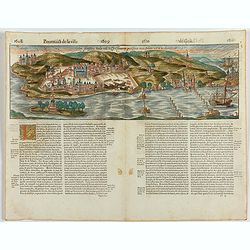
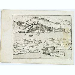
Goa fortissima Indiae urbs in Christianorum potestatem anno Salutis 1509. devenit.
A rare and early woodcut view of Goa in India. Decorated with one ship. This woodcut was published in La Cosmographie Universelle de tout le monde, printed in 1575 in two...
Date: Paris, 1575
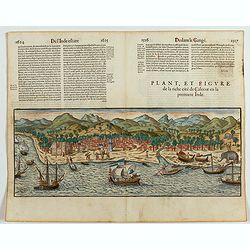
Plan, et figure de la riche cité de Calecut en la premiere Inde.
A rare and early woodcut view of Calcutta in India. Decorated with several ships on the sea, shipbuilding, fishermen and elephants.This woodcut was published in La Cosmog...
Date: Paris, 1575
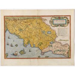
Thusciae Descriptio Auctore Hieronimo Bellarmato.
Decorative and detailed map of Tuscany, from the 1574 or 1575 Latin text edition of Ortelius' Theatrum Orbis Terrarum, the first modern atlas of the world. The map is bas...
Date: Antwerp, 1574-1575
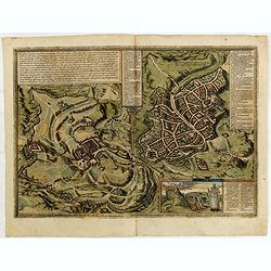
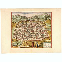
Hierosolymia, Clarissima totius Orientis civitas. . .
Two bird's eye perspectives on one sheet. The left plan shows ancient Jerusalem at the time of Christ. The view on the left also portrays the procession of Jesus to Golgo...
- $1200 / ≈ €1041
Date: Cologne, 1575
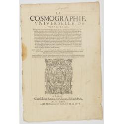
Title page from La Cosmographie Universelle..
In 1575 Sebastian Münster's Cosmographia was translated into French and published in Paris by François de Belle-Forest.
Date: Paris, 1575
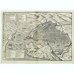
Le vray portraict de la Ville de Marseille.
Fine wood cut bird's-eye view of Marseille. Decorated with several ship in the harbour and on the sea. To the left two keys describing the main buildings and places. Publ...
Date: Paris, 1575
Pedemontanae Vicinorumque Regionum.
Fine map including the Italian coast from Monaco till Genoa. Milan in the upper righthand corner and Turin in the center of the map.
- $600 / ≈ €521
Date: Antwerp, 1574-1575
![Naumaohiae [sic] id est navalis pugnae ex vetusteis lapidum et nummorum monumenteis graphica deformatio.](/uploads/cache/49142-250x250.jpg)
Naumaohiae [sic] id est navalis pugnae ex vetusteis lapidum et nummorum monumenteis graphica deformatio.
Naval engagement set inside an arena, spectators in the stands attending the event; reclining river god and nymphs in the lower part. From "Speculum Romanae Magnific...
Date: Rome, ca. 1575
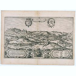
Lympurch. (Limburg)
Very desirable and early town-plan of the city of Limburg in Belgium with its fortifications at the end of the 16th century.From volume one of the greatest publication in...
- $250 / ≈ €217
Date: Cologne, 1575
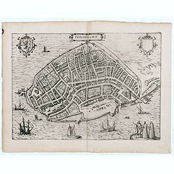
Dordrecht.
Very desirable and early town-plan of Dordrecht.From volume one of the greatest publication in this genre!. The Civitates was compiled and written by George Braun, Canon ...
- $200 / ≈ €174
Date: Cologne, 1575
![[Figura del Mondo universale].](/uploads/cache/48963-250x250.jpg)
[Figura del Mondo universale].
Münster's map of the World is one of the most recognized world maps of the 16th Century. Italian text edition published in Cologne without the title. This example is fro...
Date: Arnold Birckmann heirs, Cologne, 1575
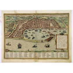
Messana, Urbs est Sicilie maxima, situ, opulentia, & tuta navium statione.
Very desirable and early town-plan of Messina on Sicily, with a numbered key (1-167) in lower part. "Messina is shown from the east, in a view looking down upon the ...
Date: Cologne, (1572) 1577
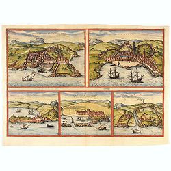
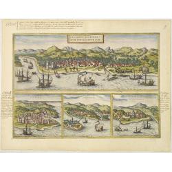
![Calechut Celeberrimum Indiae Emporium [on sheet with] Ormus [and] Canonor [and] S. Georgii Oppidum Mina.](/uploads/cache/41525-250x250.jpg)
Calechut Celeberrimum Indiae Emporium [on sheet with] Ormus [and] Canonor [and] S. Georgii Oppidum Mina.
Four desirable and early town plans of Kozhikode, Hormuz, Kannur, and Almina. "KOZHIKODE (CALICUT) : "The city is viewed from the sea, just as it would have ap...
- $800 / ≈ €694
Date: Cologne, (1572) 1577
![Sevilla, Hispalis ... [on sheet with] Cadiz [and] Malaga.](/uploads/cache/33642-250x250.jpg)
Sevilla, Hispalis ... [on sheet with] Cadiz [and] Malaga.
Very desirable and early view of Sevilla, Cadiz and Malaga, with the Roman and Moorish citadels on the hills in the background. "In the upper part Sevilla, showing ...
- $500 / ≈ €434
Date: Cologne, (1572) 1577
Leodium. (Luik or Liège)
Very desirable and early town-view of Liège, which shows the city with the Meuse flowing in its favorable location amongst gentle hills, sturdy trees and fertile fields....
- $300 / ≈ €260
Date: Cologne, (1572) 1577

Femina indica Orientalis - Indus Africanus - Singava vulgo dicta sive erratica femina Ori.
Beautiful engraving by Abraham de Bruyn showing inhabitants of Asian and African people with captions in Latin, French and German.Abraham de Bruyn, a Flemish engraver and...
Date: Cologne, c.1577
Die Statt Paris etlicher mass figuriert und contrafehtet nach jetziger Gelegenheit.
Published in the "Universal Cosmography" of S. Münster. Text in German. Under the legendary plan in German A to G. It is framed by a border composed of foliage...
- $200 / ≈ €174
Date: Bâle, H. Petri, 1578
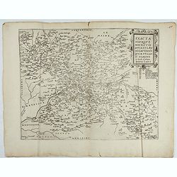
Exacta novaqve descriptio dvcatvs Andegravensis qvem vvlgari nomine Le Duche d'Aniou Indigitant.
Centered on the town of Angiers. From the first edition of De Jode's Speculum Orbis Terrarum, the second general atlas of the world, after Ortelius. Engraved by Ioannes V...
- $750 / ≈ €651
Date: Antwerp, 1578
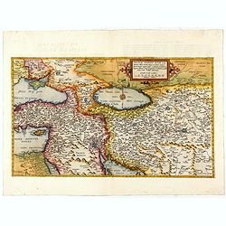
Primae Partis Asiae.
The Very Rare First State. Turkey/ Holy Land/ Iran/ Iraq/ Arabia/ Afghanistan. A superb example of the rare 1578 edition of this fine map of the Middle East, spanning fro...
- $4500 / ≈ €3905
Date: Antwerp, 1578

Americae Sive Novi Orbis, Nova Descriptio.
This is the second copperplate of Ortelius' map showing the western hemisphere, showing the prominent bulge in the South American coastline. An important map because of i...
Date: Antwerp, 1579

Schlavoniae, Croatiae, Carniale.. Bosniae. . .
First state. Fine and early map of former Yugoslavia after a map of Hirschvogel (1552-1565) and used by A.Ortelius in his atlas 'Theatrum Orbis Terrarum [Atlas of the Who...
Date: Antwerp, 1579
1) Caletensivm et Bononiensivm..2) Veromandvorvm eorvmque..
Prepared by Jean Surhon, cartographer, goldsmith and engraver. From 'Theatrum Orbis Terrarum [Atlas of the Whole World]': published in Antwerp.
- $200 / ≈ €174
Date: Antwerp, 1580
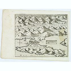
Sarmatia Asie.
The map is showing the area of Armenia and Kazakhstan. From his Cosmographia, that great compendium of Renaissance knowledge. Sebastian Münster was born in Nierder-Ingel...
- $90 / ≈ €78
Date: Basle, 1550-1580
Tingis, Lusitanis, Tangiara. / Tzaffin. / Septa. / Arzilla/ Sala.
Views of the five northern and western African coastal town-view on one sheet: Latin text.From the greatest publication in this genre!. The Civitates was compiled and wri...
- $600 / ≈ €521
Date: Cologne, 1580
Tingis, Lusitanis, Tangiara. / Tzaffin. / Septa. / Arzilla/ Sala.
Views of the five northern and western African coastal town-view on one sheet: Latin text.From the greatest publication in this genre!. The Civitates was compiled and wri...
Date: Cologne, 1580
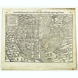
Lutetia Parisiorum urbs, toto orbe celeberrima notissimaque, caput regni Franciae.
Early bird's eye view of Paris, called at the time Lutetia. From a French text edition of S. Münster's Cosmographia, which is a short and complete summary of Renaissance...
Date: Basle, 1550-1580
![[Map of the Holy Land, including Cyprus]](/uploads/cache/33436-250x250.jpg)
[Map of the Holy Land, including Cyprus]
Attractive full page longitudinal map of Palestine, Syria and Cyprus, cut by Hans Rudolf Manuel Deutsch. The shore line running from Southern Anatolia to the Nile Delta. ...
Date: Basle, 1550-1580
![[Paris] Die Statt Paris etlicher maß figuriert und contrafehret nach jetziger Gelegenheit.](/uploads/cache/49189-250x250.jpg)
[Paris] Die Statt Paris etlicher maß figuriert und contrafehret nach jetziger Gelegenheit.
Bird's-eye view of Paris. From a German text edition of S. Münster's Cosmographia, which is a short and complete summary of Renaissance knowledge. Text in German. Under ...
Date: Basle, 1550-1580

Spectandum dedit Ortelius mortalib..
This famous portrait, engraved by Galle, was included in Ortelius' atlases from 1579 onwards.The title translation is By looking, Ortelius gave to mortal beings the world...
- $550 / ≈ €477
Date: Antwerp, 1580
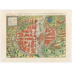
Lutezia citta de Parigini celebratissima per tuto. . .
Very early birds-eye view of Paris. From his an Italian edition of his Cosmographia, that great compendium of Renaissance knowledge. An exciting print.Engraved by Hans Ru...
Date: Basle, 1550-1580
Jerusalem.
On verso an early representation of Jerusalem (102x79mm) and underneath a temple and a church.From a German text edition of his Cosmographia , that great compendium of Re...
Date: Basle, 1550-1580
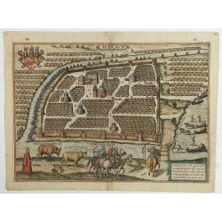
Moscavw. Moscovia, Urbs regionis eiusde nominis metropolitica, duplo maior. . .
Showing Moscow within the walled city and figures in the foreground. Title cartouche in the lower right corner Moscovia, Urbs. Regionis ciusde nominis metropolitica, dup...
Date: Cologne, 1580
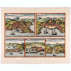
Calechut Celeberri mum Indiae Emporium/ Ormus/ Canonor, St.Georgii.
Four panoramic town-views on one sheet: The upper approximately two-thirds of this double-page sheet contains a fine panoramic view of Calicut which is on the west coast ...
Date: Cologne, 1580
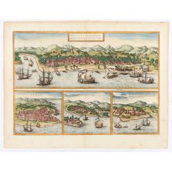
Calechut / Ormus / Canonor.
Four panoramic on one sheet: the upper approximately two-thirds of this double page sheet contains a fine panoramic view of Calicut which is on the west coast of India i...
Date: Cologne, 1580

Slusa, Teutonicae Flandriae opp. . . (Sluis)
Bird'eye view of the town of Sluis.From the greatest publication in this genre!. The Civitates was compiled and written by George Braun, Canon of Cologne Cathedral. Braun...
Date: Cologne, 1580
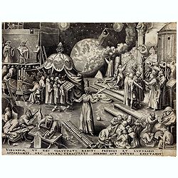
Temperance (Temperantia) from The Virtues.
Very decorative engraving by Philip Galle (Haarlem 1537–1612 Antwerp) after Pieter Bruegel the Elder (Breda (?) ca. 1525–1569 Brussels). The print was published by Hi...
Date: Antwerp, Hieronymus Cock, 1580

Tafel der Lender darin der Apostel Paulus geprediget hat.
Rare wood block map depicting the Mediterranean, with an over-sized Cyprus from the final Dutch edition of Heinrich Bünting's famous Itinerarium Sacrae Scripturae, a boo...
Date: Magdeburg, 1581

Descrittione di M. Lodovico Guicciardini patritio Fiorentino, di tutti i Paesi Bassi,...
Second Italian edition (variant B) and first Plantin edition (1st Silvius 1567) and the most sought-after edition of the famous description of the Low Countries, updated ...
Date: Antwerp, Plantin, 1581
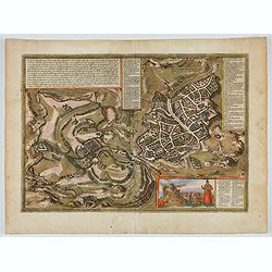
![Traiectum ad Mosam. [Maastricht]](/uploads/cache/47901-250x250.jpg)
Traiectum ad Mosam. [Maastricht]
A birds-eye view of Maastricht seen from the south. Rising on Vrijthof square is the dominant complex of Sint-Servaas, in front of which - seen here in a distorted perspe...
Date: Cologne, ca. 1581
![[Title page] De Praecipuis, Totius Universi Urbibus, Liber Secundus.](/uploads/cache/47934-250x250.jpg)
[Title page] De Praecipuis, Totius Universi Urbibus, Liber Secundus.
Allegorical title page, from Volume 2 of Braun & Hogenberg's Civitatus Orbis Terrarum.At the top are figures representing Religion and Politics, placed on either side...
Date: Cologne, 1582
Hierosolymia, Clarissima totius Orientis civitas. . .
Two bird's eye perspectives on one sheet. The left plan shows ancient Jerusalem at the time of Christ.A contemporary view of Jerusalem appears to the right with an attrac...
- $1100 / ≈ €955
Date: Cologne, 1582
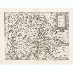
Brabantia.
Map of Brabant from Guicciardini's "Description de touts les Pais-Bais" edited by Plantin in 1582. The map drawn after Ortelius' map of Brabant, and after the l...
Date: Antwerp, 1582
Hierosolymia, Clarissima totius Orientis civitas. . .
Two bird's eye perspectives on one sheet. The left plan shows ancient Jerusalem at the time of Christ. A contemporary view of Jerusalem appears to the right with an attra...
Date: Cologne, 1582
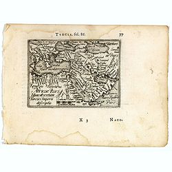
Turcici imperii descriptio.
Fine map of the Middle East, extending from Greece to Arabia and covering the Cradle of Civilisation region.Abraham Ortelius (1527-1598) was a cartographer and publisher ...
- $550 / ≈ €477
Date: Antwerp, 1583

Chinae, olim Sinarum Regionis, nova descriptio. Auctore Ludovico Georgio.
The first map of China ever to appear in a Western atlas, west to the top. The first state without "las Philiooinas" somewhere in 1587 added to the plate. When ...
Date: Antwerp, 1584
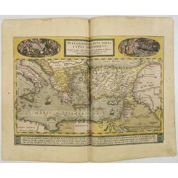
Peregrinationis Divi Pauli Typus..
A splendid map depicting the travels of Paulus. With two fine scenes in top. Showing the countries along the Mediterranean, including Cyprus and Italy. A first edition wi...
Date: Antwerp, 1584