Browse Listings
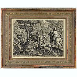
Sic leporem in laqueos agitnat per aperta fugacem - Gramina, siq canes rapidi sua terga sequutur
This is a plate from a series "Venationes ferarum, avium, piscium, pugnae bestiariorum & mutuae bestiarum". Published by Philippe Galle (Haarlem 1537 - 1612...
Date: Antwerp, Philips Galle, ca 1596
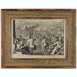
Piscantur tevetes sinuato in gargite pices.
This is a plate from a series "Venationes ferarum, avium, piscium, pugnae bestiariorum & mutuae bestiarum". Published by Philippe Galle (Haarlem 1537 - 1612...
Date: Antwerp, Philips Galle, ca 1596
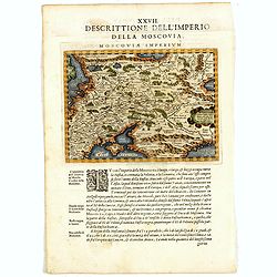
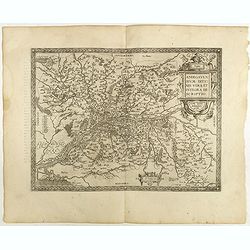
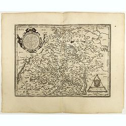
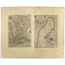
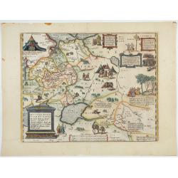
Descrittione Dell'Imperio della MOSCOVIA IMPERIUM.
Uncommon map including Latvia, Livonia, Lithuania, the Ukraine, and northern Part of the Black Sea and the Caspian Sea, Siberia, Georgia, Azerbaijan, Kazakhstan.Giovanni ...
Date: Venice, 1596

Calecuty Regnum
A rare and unusual depiction of the Indian Ocean between Madagascar, Ethiopia, southern Arabia, and south India and Ceylon.The calligraphy is florid and decorative. The e...
- $2000 / ≈ €1734
Date: Cologne, 1596
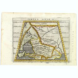
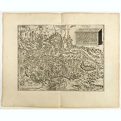
Tabula Asiae II.
A striking example of Magini's map of the Black Sea region from the 1597 edition of Magini's 'Geographia', based upon the work of Claudius Ptolemy. Latin text and tables ...
- $300 / ≈ €260
Date: Venice, 1597
![[Map of Corfu. View of the city of Corfu on the foreground. ]](/uploads/cache/45221-250x250.jpg)
[Map of Corfu. View of the city of Corfu on the foreground. ]
Very rare map of Corfu with a view of the city of Corfu on the foreground. Published in the first edition of "Viaggio da Venetia, a Costantinopoli. Per Mare, e per T...
Date: Venice, Giacomo Franco, 1598
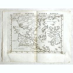
India Tercera Nuova Tavola.
Fine 1598 edition of this early map of South East Asia. Just to the west and south of Malacca, one will notice ‘Camatra’ (Sumatra) and Java. China with Canton in the ...
- $1000 / ≈ €867
Date: Venice, 1598

Carinthiae et Goritiae... / Histria tabula.../ Zarae, et Serebenici ..
Three maps on one sheet. The left hand is centered on the eastern part of Austria. The right upper hand map is centered on northern Yugoslavia, and the last map is center...
Date: Antwerp, 1598
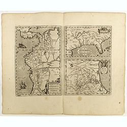
La Florida/ Peruviae Auriferae regionis Typus/ Guastecan.
The Chaves map of Florida is a prime example of an explorer's map since it records the recent discoveries of Cabeza de Vaca, De Soto, and Moscoso. The map revealed little...
Date: Antwerp, 1598
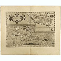
Culiacanae Americae regionis.. / Hispaniolae, Cubae..
Two virtually identically sized inset maps on one sheet, each with a decorative scroll title cartouche. Culiacanae depicts the coastal and inland western region in North ...
Date: Antwerp, 1598

Angliae Regni florentissimi nova descriptio..
Fine general map of England derived from Mercator's 1564 map of the British Isles in 8 sheets.Dare to go in Black. All early maps were printed in black and white; many we...
Date: Antwerp, 1598

Angliae, scotiae, et Hiberniae, sive Britannicar:insularum.
Fine general map of the British Isles and Ireland on horizontal projection with north to right of page. Derived from Mercator's 1564 map of the British Isles.Dare to go i...
Date: Anwerp, 1598
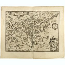
Namurcum Comitatus.
Prepared by Jacques Surhon in 1555. His manuscript map was, for security reasons not published. Only in 1579, when Antwerp was independent for a short time, Ortelius used...
Date: Antwerp, 1598
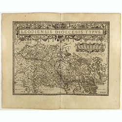
Leodiensis Diocesis Typus.
East to the top. Centered on Liege, including the southern part of Dutch Limburg. Prepared by Jan van Schille.Dare to go in Black. All early maps were printed in black an...
Date: Antwerp, 1598

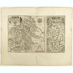
Gelriae, Cliviae, Finitimorumque Locorum Verissima..
East to the top. Fine map of Geldria and Limburg, prepared by Christian s'Grooten. Very fine title cartouche lower right with painter's utensils around the cartouche. ...
Date: Antwerp, 1598
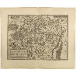
Lutzenburgen sis Ducatus Veriss. Descript.
An attractive map of Luxembourg: title cartouche on the lower left corner. From 'Theatrum Orbis Terrarum [Atlas of the Whole World]'.Iacobo Surhonio Montano auctore. D...
Date: Antwerp, 1598
Anjou. Andegavensium Ditionis Vera et Integra Descriptio. Licimo Guijeto Andegavense auctore.
Beautiful map of the Anjou region of western France along the Loire River. Include the city of Angers in the center. Accompanying French text on verso. Dare to go in B...
Date: Antwerp, 1598
![Blaisois Blesiensis Territorii. . . [together with] - Lemovicum totius et confinium provinciarum. . .](/uploads/cache/40963-250x250.jpg)
Blaisois Blesiensis Territorii. . . [together with] - Lemovicum totius et confinium provinciarum. . .
The map on the left is centered on the Loire with the town of Blois. The right-hand map is centered on Limoges. Dare to go in Black. All early maps were printed in bla...
Date: Antwerp, 1598
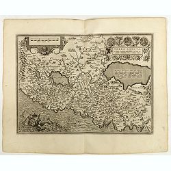
Regionis Biturigum... Per Ioannem Calamaeum. / Limaniae Topographia Gabriele Symeoneo Auct.
Two maps on one sheet. Biturigum. The Loire river is on the right in central France. Neuers (Nevers) is at the middle of the right margin. Bourges is near the center, and...
Date: Antwerp, 1598

Hollandiae Antiquorum Catthorum..
This map shows Holland in great detail, including small towns, walled cities, rivers and lakes (many of which were reclaimed in the 17th century, and no longer exist). A ...
Date: Antwerp, 1598

Artois. Atrebatum Regionis Vera Descripto.
Prepared by Jacob Surhon, who made a manuscript map of Artois for which he received 36 Livres from Charles V in 1554. For security reasons, the map was not published. Onl...
Date: Antwerp, 1598

Romaniae, (quae olim Thracia dicta) ..
Very fine map centered on the Danube area. The map is based on the double sheet map by Jacob Gastaldi. Abraham Ortelius (1527-1598) was a cartographer and publisher, who ...
Date: Antwerp, 1598
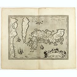
IAPONIAE INSULAE DESCRIPTIO.Ludoico Teisera auctore.
The map was based upon the manuscript draft supplied to Ortelius in about 1592 by the famous official Portuguese chart maker, Luis Teixeira , who was the cartographer t...
Date: Antwerp, 1598
Terra Sancta A Petro Laicstain perlustrata, et ab eius ore
Oriented to the east. Shows the shoreline from Beirut to Gaza. P. Laicksteen, a Dutch astronomer… collected topographic material on Palestine during his stay there in 1...
Date: Antwerp, 1598
Natoliae Quae Olim Asia Minor, Nova de Scriptio / Carthaginis Celeberrimi Sinus Typus / Aegypti re Centior de Scriptio
Three detailed regional maps by Ortelius from his "Theatrum Orbis Terrarum", the world's first modern atlas.The first map covers Asia Minor, Cyprus and the East...
Date: Antwerp, 1598
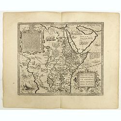
Presbiteri Johannis, sive Abissinorum Imperii descriptio.
Depicting Africa from the Mediterranean to the Mountains of the Moon placed just below Mozambique. Dare to go in Black. All early maps were printed in black and white,...
Date: Antwerp, 1598

Barbariae et Biledulgerid, nova descriptio.
North-West Africa. Koeman speculated: "In view of the important trading relationship between Antwerp and Africa, it is not impossible that the original was a manuscr...
Date: Antwerp, 1598
Moraviae.
This early map of Slovakia was prepared by Paul Fabritius in 1569, centered on the city of Brno. Title cartouche on the upper left corner. Abraham Ortelius (1527-1598) wa...
Date: Antwerp, 1598

Silesiae typus..
Fine and early map of Silesia after Martin Helwig (1516-1574) and used by A.Ortelius in his atlas 'Theatrum Orbis Terrarum [Atlas of the Whole World].Only included in the...
Date: Antwerp, 1598
Helvetiae Descriptio . . .
A fine map based upon a map by the Swiss cartographer Aegidicus Tschudi of 1538.Dare to go in Black. All early maps are printed in black and white and many were kept that...
Date: Antwerp, 1598

Florentini Dominii Fidelissima et nova descriptio.
The map is centered on the city of Florence and extends to Liguria, the Apennine Mountains, the Adriatic Coast, Siena and Lago di Perugia. The map is based upon Stefano B...
Date: Anvers, 1598
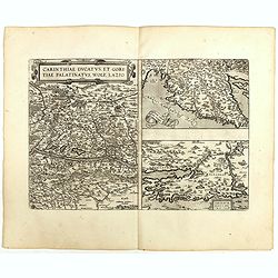
Carinthiae et Goritiae .. / Histria / Zarae / Serebenici. . .
Three maps on one sheet. The left-hand is centered on the eastern part of Austria. The upper right-hand map is centered on northern Yugoslavia, and the last map is center...
Date: Antwerp, 1598
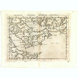
Arabia Felice Nuova Tavola.
Fine early map of Arabian peninsula, being one of the earliest modern maps of the region.Girolamo Ruscelli first published the map in his "La Geographi di Claudio To...
- $850 / ≈ €737
Date: Venice, 1598
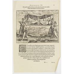
Argumentum VI. De modis quibus de loco in locum, feruorum aut conductitiorum humeris transferri Folent. (How the Congolese are transported)
How the Congolese are transported. None of the horses (probably zebras) are tame enough to ride and the people seem incapable of training the oxen to pull wagons for the ...
- $100 / ≈ €87
Date: Frankfurt, 1598
Mansfeldiae Comitatus.
A very fine map centered on the city of Mansfelt . A very nice title cartouche in the upper right corner. Signed by the engraver Franz Hogenberg lower left. Abraham Ortel...
- $75 / ≈ €65
Date: Antwerp, 1598
Basiliensis territorii descriptio nova./Circulus sue Liga. . .
Left-hand map centered on Basel, east to top. With credit to Sebastian Münster in the title cartouche. Right-hand map with Boden See, Strasbourg and Augsburg. The map wa...
- $300 / ≈ €260
Date: Antwerp, 1598
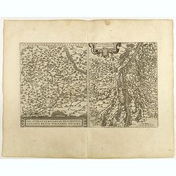
Palatinatvs Bavariae . . . / Argentoratensis agri . . .
From 'Theatrum Orbis Terrarum [Atlas of the Whole World]. The left-hand map of Bavaria is after Erhart Reych's 4-sheet map of 1540. Including the towns of Regensburg, Nü...
- $100 / ≈ €87
Date: Antwerp, 1598
![Larii Lacus Vulgo Comensis Descriptio . . . [and] Terretorii Romani Descrip. [and] Fori Iulii Vulgo Frivli Typus. . .](/uploads/cache/41008-250x250.jpg)
Larii Lacus Vulgo Comensis Descriptio . . . [and] Terretorii Romani Descrip. [and] Fori Iulii Vulgo Frivli Typus. . .
Set of 3 maps on one sheet of Lake Como, the region around Rome and the region around the Upper Adriatic, centered on Udinese from 'Theatrum Orbis Terrarum [Atlas of the ...
Date: Antwerp, 1598
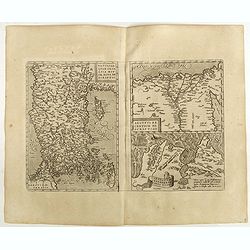
Patavini territorii../ Tarvisini agri typus.. (2 maps on one sheet)
Two maps on one sheet. Map to the left is a detailed map including Venice and the area north of it, including Padua and Vincenza. Very fine map after Giacomo Gastaldi. Th...
- $300 / ≈ €260
Date: Antwerp, 1598
![Plants found in the island of S. Laurenti [Madagascar].](/uploads/cache/41368-250x250.jpg)
Plants found in the island of S. Laurenti [Madagascar].
‘ A’ denotes a tree with only a few twigs on the top. From this tree, canoes and boats are made. ‘B’ is a bush that the Dutch frequently encountered and was calle...
- $80 / ≈ €69
Date: Frankfurt, 1598
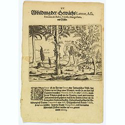
Plants Lantor, Assa, Pimenta, Mangostan and Pepper.
Lantor is a kind of coconut palm (or Indian nut) with fronds as long as a human body. These fronds are used as paper. Pimenta del Rabo (or cubebe) grows grape-like on tre...
- $80 / ≈ €69
Date: Frankfurt, 1598
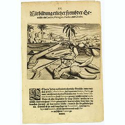
Plants, including the canior, diringuo, pucho and chiabe.
In the Indies there are many delightful plants, which include the ‘costus indicus’ (named by the Malays 'pucho') that has a wonderful aroma. Then there is the ‘cala...
Date: Frankfurt, 1598
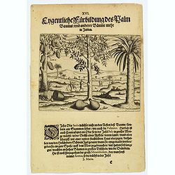
A picture of various trees including the palm tree.
The Jacca fruit grows only on the trunk of the tree, not on its branches, rather like the fruit of the palmates. Then there is a fruit that grows in abundance in Bali, wh...
- $80 / ≈ €69
Date: Frankfurt, 1598
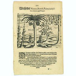
Pineapple, Bettel, palma dactylifera, Samaca & Mango.
These are all Indian fruits, of which the pineapple has the best flavour and aroma. The Bettel plant is also shown here climbing up long rods and canes, just as the peppe...
- $100 / ≈ €87
Date: Frankfurt, 1598
![Spalato [ View of Split]](/uploads/cache/45201-250x250.jpg)
Spalato [ View of Split]
Very rare view of Split published in the first edition of "Viaggio da Venetia, a Costantinopoli. Per Mare, e per Terra, & infieme quello di Terra Santa. Da Giose...
- $450 / ≈ €390
Date: Venice, Giacomo Franco, 1598
![Zafalonia [Map of Kefalonia]](/uploads/cache/45223-250x250.jpg)
Zafalonia [Map of Kefalonia]
Very rare map of the island of Kefalonia published in the first edition of "Viaggio da Venetia, a Costantinopoli. Per Mare, e per Terra, & infieme quello di Terr...
- $450 / ≈ €390
Date: Venice, Giacomo Franco, 1598
![[Map of Zakynthos or Zante]](/uploads/cache/45226-250x250.jpg)
[Map of Zakynthos or Zante]
Very rare map of Zakynthos or Zante, a Greek island in the Ionian Sea. It is the third largest of the Ionian Islands. Published in the first edition of "Viaggio da V...
- $450 / ≈ €390
Date: Venice, Giacomo Franco, 1598
![[Map of Morea]](/uploads/cache/45228-250x250.jpg)
[Map of Morea]
Very rare map of the island Morea published in the first edition of "Viaggio da Venetia, a Costantinopoli. Per Mare, e per Terra, & infieme quello di Terra Santa...
- $450 / ≈ €390
Date: Venice, Giacomo Franco, 1598
![Candia [Map of the island Crete]](/uploads/cache/45233-250x250.jpg)
Candia [Map of the island Crete]
Very rare map of the island Crete published in the first edition of "Viaggio da Venetia, a Costantinopoli. Per Mare, e per Terra, & infieme quello di Terra Santa...
Date: Venice, Giacomo Franco, 1598
![Rhodi [Map of Rhodes]](/uploads/cache/45235-250x250.jpg)
Rhodi [Map of Rhodes]
Very rare map of Rhodes Island published in the first edition of "Viaggio da Venetia, a Costantinopoli. Per Mare, e per Terra, & infieme quello di Terra Santa. D...
Date: Venice, Giacomo Franco, 1598
![Rodi [View of Rhodes]](/uploads/cache/45236-250x250.jpg)
Rodi [View of Rhodes]
Very rare view of the City of Rhodes on the island of Rhodes. Historically, Rhodes island was very famous worldwide for the Colossus of Rhodes, one of the Seven Wonders o...
Date: Venice, Giacomo Franco, 1598

Jerusalem.
Very rare view of Jerusalem published in the first edition of "Viaggio da Venetia, a Costantinopoli. Per Mare, e per Terra, & infieme quello di Terra Santa. Da G...
Date: Venice, Giacomo Franco, 1598

Santorini.
Very rare map of Santorini published in the first edition of "Viaggio da Venetia, a Costantinopoli. Per Mare, e per Terra, & infieme quello di Terra Santa. Da Gi...
Date: Venice, Giacomo Franco, 1598
![Stampalia. [Map of Astypalaia]](/uploads/cache/45244-250x250.jpg)
Stampalia. [Map of Astypalaia]
Very rare map of the Greek island Astypalaia. The island is known in Italian as Stampalia. Published in the first edition of "Viaggio da Venetia, a Costantinopoli. P...
Date: Venice, Giacomo Franco, 1598
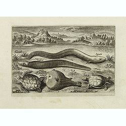
Anguilla, Congrus, Orbis, Tesludo marina, Tesludo. (Piscium Vivæ Icones - Fish)
Blowfish, turtle, eel, etc. set against a mountainous landscape in the manner of Pieter Brueghel the Elder. Plate number 7. The engraving is copied after Adrian Collaert ...
- $200 / ≈ €173
Date: Antwerp, after 1598
Cepola, Rosmarus, Adonis, Hirunda. (Piscium Vivæ Icones - Fish)
Depiction of Cepola, Rosmarus, Adonis, Hirunda, set against a mountainous landscape in the manner of Pieter Brueghel the Elder. Plate number 5. The engraving is copied af...
Date: Antwerp, after 1598
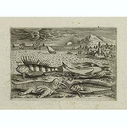
Lampreta, Rayu, Erica, Lira. (Piscium Vivæ Icones - Fish)
Depiction of Lampreta, Rayu, Erica, Lira, set against a mountainous landscape in the manner of Pieter Brueghel the Elder. Plate number 4. The engraving is copied after Ad...
Date: Antwerp, after 1598
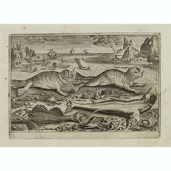
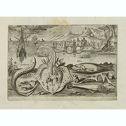
Canis marinus. Cuculus. Silurc (Piscium Vivæ Icones - Fish)
Two seals and fishes, set against a mountainous landscape in the manner of Pieter Brueghel the Elder. Plate number 3. The engraving is copied after Adrian Collaert plate ...
Date: Antwerp, after 1598
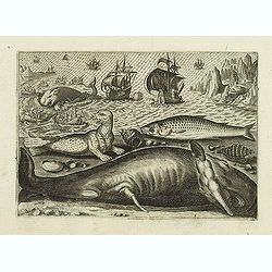
Virulus marinus. Cete (Whale and whaling scene)
Whale and whaling scene, set against a mountainous landscape in the manner of Pieter Brueghel the Elder. Plate number 1. The engraving is copied after Adrian Collaert pla...
Date: Antwerp, after 1598
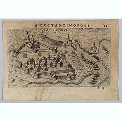
Castel Novo
Very rare view of Herceg-Novi, an important fortress belonging to Venetian Dalmatia captured during the 16th century by the Turks. Published in the first edition of "...
Date: Venice, Giacomo Franco, 1598

Quella Tavola E l'Antica Siria ch'Era destinta in dodici . . .
Very rare view of Holy Land published in the first edition of "Viaggio da Venetia, a Costantinopoli. Per Mare, e per Terra, & infieme quello di Terra Santa. Da G...
Date: Venice, Giacomo Franco, 1598

Scio. (Chios)
Very rare view of Chios Island published in the first edition of "Viaggio da Venetia, a Costantinopoli. Per Mare, e per Terra, & infieme quello di Terra Santa. D...
Date: Venice, Giacomo Franco, 1598

Metileme. (Lesbos)
Very rare map of Lesbos published in the first edition of "Viaggio da Venetia, a Costantinopoli. Per Mare, e per Terra, & infieme quello di Terra Santa. Da Giose...
Date: Venice, Giacomo Franco, 1598
![Citta Di Trav [Trogir]](/uploads/cache/45200-250x250.jpg)
Citta Di Trav [Trogir]
Very rare map centered on the historic town of Trogir published in the first edition of "Viaggio da Venetia, a Costantinopoli. Per Mare, e per Terra, & infieme q...
- $300 / ≈ €260
Date: Venice, Giacomo Franco, 1598
![[View of Osero].](/uploads/cache/45194-250x250.jpg)
[View of Osero].
Very rare view of Osor published in the first edition of "Viaggio da Venetia, a Costantinopoli. Per Mare, e per Terra, & infieme quello di Terra Santa. Da Giosep...
- $400 / ≈ €347
Date: Venice, Giacomo Franco, 1598
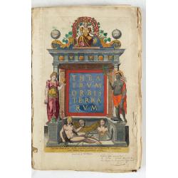
Il theatro del mondo di Abraamo Ortelio…
Very rare first Italian edition issued in Brescia in 1598 by Pietro Marchetti. ; l theatro del mondo... Nel quale distinamenti si dimostrano in tavole tutte le provincie...
Date: Brescia (appresso la Compagnia Bresciana), 1598

A cidade de Angra na ilha de Iesuxpo da Tercera..
Spectacular perspective view of the harbour and town of Angra on the island of Terceira in the Azores. It was at the time an important port and administrative centre of t...
Date: Amsterdam, 1598
Theatrum Orbis Terrarum.
A Dutch edition of Ortelius' Theatrum Orbis Terrarum "Ghedruckt voor A. Ortelius" (by Corn. Claesz.?), 1598. Illustrated with 92 maps, 91 maps numbered 1-91, in...
- $100000 / ≈ €86681
Date: (Amsterdam, Corn. Claesz.) ?, 1598
Russiae, Moscoviae et Tartariae Descriptio.
Engraved by Frans Hogenberg from an original of 1562 by Anthony Jenkinson of the English Muscovy Company. The many vignettes are based on the reports of Marco Polo's expl...
Date: Antwerp, 1598

Regionis Biturigum... Per Ioannem Calamaeum. / Limaniae Topographia Gabriele Symeoneo Auct.
Two maps on one sheet. Biturigum. The Loire river is at the right in central France. Neuers (Nevers) is at the middle of the right margin. Bourges is near the center, an...
- $125 / ≈ €108
Date: Antwerp, ca. 1598
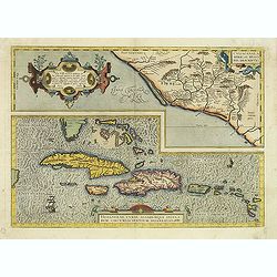
Culiacanae Americae regionis.. / Hispaniolae, Cubae..
Two separate virtually identically sized inset maps on one sheet, each with a decorative scroll title cartouche. Culiacanae depicts the coastal and inland western region...
Date: Antwerp 1598
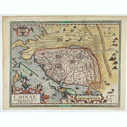
Chinae, olim Sinarum regionis. . .
The first printed map of China. It is signed by Ludovico Georgio, whose real name was Luis Jorge de Barbuda. He was a Portuguese Jesuit cartographer and besides that a sp...
Date: Antwerp, 1598
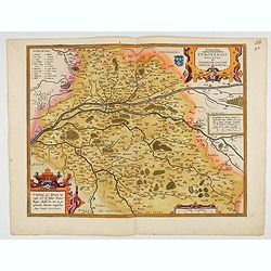
Touraine. Turonensis Ducatus.
Map of Touraine Duché in very fine original colours.
Date: Antwerp, 1598

Chinae, olim Sinarum regionis. . .
The first printed map of China. It is signed by Ludovico Georgio, whose real name was Luis Jorge de Barbuda. He was a Portuguese Jesuit cartographer and besides that a sp...
Date: Antwerp, 1598
![Dulcigno [Ulcinj in Montenegro]](/uploads/cache/45211-250x250.jpg)
Dulcigno [Ulcinj in Montenegro]
Very rare view of Ulcinj in Montenegro published in the first edition of "Viaggio da Venetia, a Costantinopoli. Per Mare, e per Terra, & infieme quello di Terra ...
- $450 / ≈ €390
Date: Venice, Giacomo Franco, 1598
![Liesena Isola [Hvar]](/uploads/cache/45202-250x250.jpg)
Liesena Isola [Hvar]
Very rare view map of the Island of Hvar published in the first edition of "Viaggio da Venetia, a Costantinopoli. Per Mare, e per Terra, & infieme quello di Terr...
- $400 / ≈ €347
Date: Venice, Giacomo Franco, 1598
![Glissa. [Klissza or Klis]](/uploads/cache/45203-250x250.jpg)
Glissa. [Klissza or Klis]
Very rare view of Klissza (Klis) published in the first edition of "Viaggio da Venetia, a Costantinopoli. Per Mare, e per Terra, & infieme quello di Terra Santa....
- $300 / ≈ €260
Date: Venice, Giacomo Franco, 1598
![Budova [Budua in Montenegro]](/uploads/cache/45209-250x250.jpg)
Budova [Budua in Montenegro]
Scarce map centered on Budua in Montenegro was published in the first edition of "Viaggio da Venetia, a Costantinopoli. Per Mare, e per Terra, & infieme quello d...
- $450 / ≈ €390
Date: Venice, Giacomo Franco, 1598
![[ Map with part of Albania]](/uploads/cache/45210-250x250.jpg)
[ Map with part of Albania]
Very rare view of part of the coast of Albania published in the first edition of "Viaggio da Venetia, a Costantinopoli. Per Mare, e per Terra, & infieme quello d...
- $450 / ≈ €390
Date: Venice, Giacomo Franco, 1598
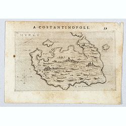
Murgo.
Very rare map of Amorgos published in the first edition of "Viaggio da Venetia, a Costantinopoli. Per Mare, e per Terra, & infieme quello di Terra Santa. Da Gios...
- $300 / ≈ €260
Date: Venice, Giacomo Franco, 1598