Browse Listings in Europe > British Isles
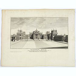
Blenheim House.
An attractive view of the front of Blenheim House (now Palace) home to the present 12th Duke and Duchess of Marlborough. The house was begun in 1705, built by Sir John Va...
- $50 / ≈ €44
Date: London, ca. 1760

Nieuwe Paskaart van het Westerlykste Gedeelte van HET KANAAL strekkende aan de ENGELSCHE KUST van Poortland tot de Sorlinges. . .
Nieuwe Paskaart van het Westerlykste Gedeelte van HET KANAAL strekkende aan de ENGELSCHE KUST van Poortland tot de Sorlinges en aan de Fransche kust van het Eylandt Guern...
- $900 / ≈ €785
Date: Amsterdam, 1760
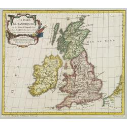
Les Isles Britanniques..
A first state (of 2) dated 1762. Fine map of the British Isles, engraved by E.Dussy. Fine title cartouche upper left engraved by Arrivet. From his Nouvel Atlas Portatif .
Date: Paris, 1762
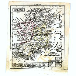
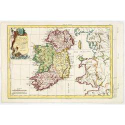
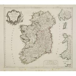
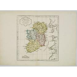
Ireland.
Uncommon miniature map of Ireland, engraved by J. Bayly for "A New General and Universal Atlas Containing Forty five Maps by Andrew Dury".This miniature atlas p...
- $50 / ≈ €44
Date: London, 1761-1763
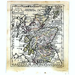
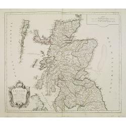
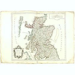
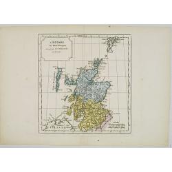
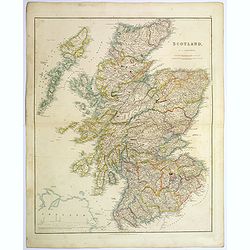
A map of Scotland.
Uncommon miniature map of Scotland, engraved by Thomas Kitching for "A New General and Universal Atlas Containing Forty five Maps by Andrew Dury".This miniature...
- $50 / ≈ €44
Date: London, 1761-1763
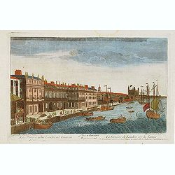
Vue d'optique representant La Douane de Londres sur la Tamise. . .
Showing the Customs office in London seen from the River Thames. Published by Daumont, who was a well-known publisher of optical prints, established in rue St. Jacques in...
- $200 / ≈ €175
Date: Paris, ca. 1770
L'Irlande. . .
Map of Ireland, prepared by M. Philippe, embellished with a decorative title cartouche. Engraved by Vallet.
Date: Paris, 1779

Vue interiere de la Cathedrale de St.Paul a Londres.
So-called optical print, engraved by F.Leizelt. In the eighteenth and nineteenth centuries there were many popular speciality establishments in Paris, Augsburg and London...
Date: Augsburg 1780
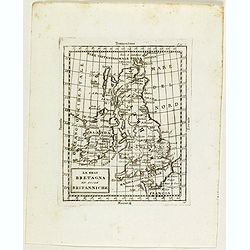
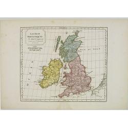
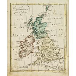
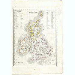
La Gran Bretagna ed isole Britanniche.
Rare map of Great Britain with Ireland, from "Atlante Novissimo ad uso Dei Giovani Studiosi Contenuto In Carte XXVII.", published by Giovanni Zempel in Rome, ca...
Date: Rome, 1780
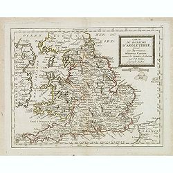
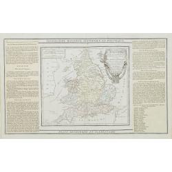
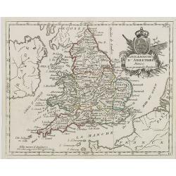
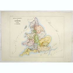
Carte Du Royame D'Angleterre..
Attractive map of England, ornated with a rococo title cartouche. Boundaries outlined in hand color.From theAtlas moderne ou collection de cartes sur toutes les parties d...
Date: Paris, ca 1783
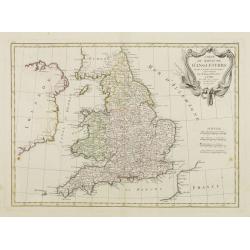
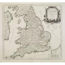
Carte du Royaume d'Angleterre. . .
Scarce map of England prepared by Nolin and published by L.J. Mondhare for his Atlas Général a l'usage des colleges et maisons d'education.Louis Joseph Mondhare was act...
- $100 / ≈ €87
Date: Paris, 1783
Royaume d'Irelande.. et subdivisé en Comtés.
Finely and crisply engraved map of Ireland.Venetian edition of Giles Didier Robert De Vaugondy's map from Atlas Universel printed in 1776-84.Ornamental title cartouche in...
Date: Venice, 1776 - 1784
L'Ecosse divisée en Shires et Comtés.
Finely and crisply engraved map of Scotland.Venetian edition of Giles Didier Robert De Vaugondy's map from Atlas Universel printed in 1776-84.Ornamental title cartouche i...
Date: Venice, 1776 - 1784
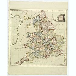
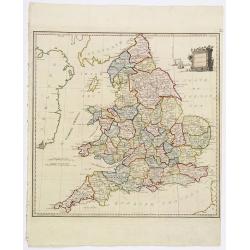
Le royaume d'Angleterre..subdivisé en Shires ou Comtés.
Finely and crisply engraved map of British Isles including the coasts of France and Ireland.Venetian edition of Giles Didier Robert De Vaugondy's map from Atlas Universel...
Date: Venice, 1778 - 1784
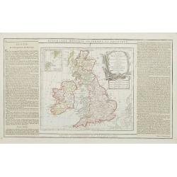
Les Isles Britanniques. . .
Detailed map encompassing present day British Isles.Venetian edition of the map by Bellin, to whom Santini gives credit in the cartouche.From "Atlas Universel" ...
Date: Venice, 1776 - 1784
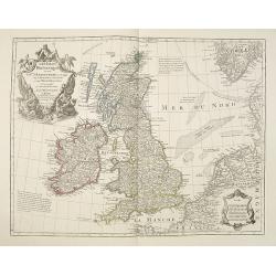
Les Isles Britanniques Comprenant les Royaumes D'Angleterre, D'Ecosse et D'Irlande divisée en grands provinces. . .
Detailed map encompassing present day British Isles. An inset in the upper right details the Shetland and Orkney Islands. Venetian edition of the map by Janvier, to whom ...
Date: Venice, 1776 - 1784
L'Ecosse divisée en Shires et Comtés.
Finely and crisply engraved map of Scotland.Venetian edition of Giles Didier Robert De Vaugondy's map from Atlas Universel printed in 1776-84.Ornamental title cartouche i...
Date: Venice, 1776 - 1784
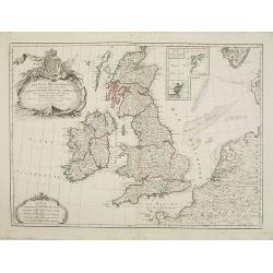
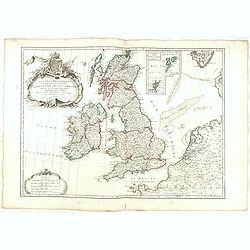
Les Isles Britanniques..
An attractive map of the British Isles including an inset of the Orkney and Shetland Islands. Finely embellished with a large title cartouche.The map is flanked by two co...
- $90 / ≈ €79
Date: Paris, 1790
L'Angleterre divisée en 5 grandes Parties. . .
A very attractive map of England and Wales showing its 52 counties and the major cities as well as five large regional divisions.Finely embellished with a large title car...
- $100 / ≈ €87
Date: Paris, 1790
Present Britain.
A fully colored map of England and Wales from An Universal Atlas Consisting of a Complete Set of Maps, peculiarly adapted to illustrate and explain ancient and modern geo...
Date: London, 1797
Present Britain.
A fully colored map of England and Wales from An Universal Atlas Consisting of a Complete Set of Maps, peculiarly adapted to illustrate and explain ancient and modern geo...
Date: London, 1797
Les Isles Britanniques ou sont le Rme. D'Angleterre . . . Par G. De L'Isle. . . A Paris Chez Dezauche. . .
Uncommon late edition, (dated An 8, 1800 ) of this map of the British Isles prepared by DeL'Isle and published during the French Revolution by Dezauche / Buache. The bott...
Date: Paris, 1800

Bowles's new four-sheet map of England and Wales. . .
Bowles's new four-sheet map of England and Wales: Comprehending all the Cities, Boroughs, Market and Sea-Port Towns, Villages, Lakes, Rivers, Forests, Ruins, Canals, and ...
Date: London, 1801
L' Irlande.
Map of Ireland. By C. F. Delamarche, successor of Robert de Vaugondy, Geographer.
- $90 / ≈ €79
Date: Paris, 1794 - 1806
L' Ecosse.
Map of Scotland. By C. F. Delamarche, successor of Robert de Vaugondy, Geographer.
Date: Paris, 1794 - 1806
Les Isles Britanniques.
Map of British Isles. By C. F. Delamarche, successor of Robert de Vaugondy, Geographer.
- $80 / ≈ €70
Date: Paris, 1794 - 1806
Carte du Royaume d' Angleterre . . .
Map of England and its counties, from Atlas moderne portatif composé de vingt-huit cartes sur toutes les parties du globe terrestre .. A l'usage des Colléges, des Pensi...
Date: Paris, Prudhomme, Levrault, Debray, 1806
Grossbritanien und Irland.
Nice small map of the British isles and Ireland by Johannes Walch in his rare Allgemeiner Atlas Nach den bewährsten Hülfsmitteln und astronomischen Ortsbestimungen…, ...
- $50 / ≈ €44
Date: Augsburg, 1812

Langley's New Travelling and Commercial Map . . .
A highly desirable, detailed and uncommon map of England and Wales, published by Langley and Belch. The map is flanked by a pair of large and detailed explanation tables,...
Date: London, 1817

London in Miniature With The Surrounding Villages. An Entire New Plan In which the Improvements both present and intended are actually reduced, by permission, from the surveys of the Several Proprietors. . .
Hand-coloured engraved map, dissected and mounted on linen, orange publishers label on one side, extending west to east from Kensington to East India and Greenwich Dock a...
Date: London, 1821
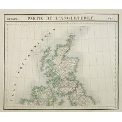
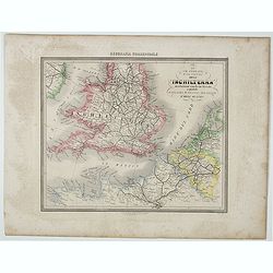
Europe. Partie de l'Angleterre. N°7.
Detailed map including Northern part of England.From his famous Atlas Universel . This atlas was one of the most remarkable world atlases ever produced, anticipating the ...
- $100 / ≈ €87
Date: Brussels, 1825-1827
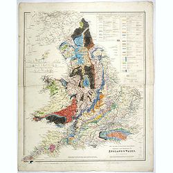
The Inland Navigation, Rail Roads, Geology and Minerals of England & Wales.
A beautifully color-coded and robustly labelled map describes the geology of England and Wales. The colors indicate particular rock materials in accordance with a key at ...
Date: London, 1834
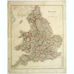
England.
A large and detailed steel-engraved map of England, with each county divided by a different color. Many place names and physical features are shown, illustrating how dens...
Date: London, 1839
Scotland.
An attractive steel engraved map of Scotland, with each county divided by a different color. Many place names and physical features shown.The Arrowsmith family members we...
Date: London, 1839

Wallis's Guide for Strangers Through London.
Engraved plan with original hand-coloring, with title and alphabetical list of the principal streets below. Published by Edward Wellis 42 Skinner Street.With "An alp...
Date: London, E.Wallis, ca. 1840
Iles Britanniques.
Detailed British Islands map, prepared by Charles V. Monin (fl.1830-1880) a French cartographer of Caen and Paris. Published in Atlas Universel de Géographie Ancienne &a...
- $25 / ≈ €22
Date: Paris, 1845
Provincia ecclesiastica di Westminster Londra in Inghilterra (Tav LXXXIV)
A large-format map of the British Isles with its different dioceses. The map is finely engraved and beautifully colored and was prepared by Girolamo Petri, a lawyer who s...
- $300 / ≈ €262
Date: Rome, 1858
![[Scotland] Vicariati Apostolici nella Scozia (Tav LXXXV)](/uploads/cache/44125-250x250.jpg)
[Scotland] Vicariati Apostolici nella Scozia (Tav LXXXV)
A large-format map of Scotland with its different dioceses. The map is finely engraved and beautifully colored and was prepared by Girolamo Petri, a lawyer who served as ...
- $350 / ≈ €305
Date: Rome, 1858
Le Vie Ferrate e Postali dell' Inchilterra . . .
Uncommon map of England and part of France prepared by Francesco Costantino Marmocchi. Above the map "Geografia Commerciale". From "Il Globo Atlante di car...
Date: Genova, Paolo Rivara fu Giacomo, 1858
![[British Isles] Circoscrizione delle Province ecclesiastiche e Diocesi d'Inghilterra Irlanda e dei Vicariati in scozia (Tav LXXXIII)](/uploads/cache/44123-250x250.jpg)
[British Isles] Circoscrizione delle Province ecclesiastiche e Diocesi d'Inghilterra Irlanda e dei Vicariati in scozia (Tav LXXXIII)
This large-format British Isles map is finely engraved and beautifully colored and was prepared by Girolamo Petri, a lawyer who served as a senior official within the Vat...
- $250 / ≈ €218
Date: Rome, 1858

AFFAIRES D'ORIENT Départ des Grenadiers de la Garde Anglaise, à bord du Steamer transatlantique l'Orenoco. . .
Beautiful lithography of the British steamboat "l'Orenoco" departure from Southampton in May 1854, with soldiers leaving for the Crimean War. After a design Lou...
Date: Paris, Lemercier, c.1860
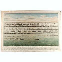
The Royal Naval review at Spithead, June 26th, 1897. In Honour of Her Majesty Queen Victoria's Diamond Jubilee.
A very decorative and large chromolithographed plate showing a line up of international vessels at Spithead, June 26th, 1897 In Honour of her Majesty Queen Victoria'a Dia...
Date: Portsea, ca. 1897
![[The United Kingdom - Sweden, Norway, Denmark].](/uploads/cache/46169-250x250.jpg)
[The United Kingdom - Sweden, Norway, Denmark].
Alexey Afinogenovich Ilyin was a lieutenant general and cartographer (1832-1889). In 1856, after graduating from the Academy of the General Staff, he was at the military ...
- $50 / ≈ €44
Date: St. Petersburg, 1899
![[Oxford Canal from Oxford to Coventry].](/uploads/cache/37232-250x250.jpg)
[Oxford Canal from Oxford to Coventry].
Manuscript map covering the Oxford Canal. Orientated East to the North. The Oxford Canal is a 78-mile-long (126 km) narrow canal in central England linking Oxford with Co...
- $140 / ≈ €122
Date: ca. 1900
![[West Central London from Booth's Poverty Map of London]](/uploads/cache/40267-250x250.jpg)
[West Central London from Booth's Poverty Map of London]
A map of West Central London, one section (of twenty) of an extended version of the incredibly influential Poverty Map, originally published in Charles Booth's 'Life and ...
Date: London, 1900

A very early large London Underground enamel station sign for Westerminster Station
This large enamel sign can be dated between 1908 and 1915, when the bull’s-eye design, a solid red disk with a horizontal bar containing the text, was adopted by all th...
- $22000 / ≈ €19201
Date: London, ca. 1908-1915

The Wonderground Map of London.
A large and pictorially striking 'Wonderland' advertising poster on behalf of the London Underground, published in the late 1920s. The poster was very popular, and ran fo...
Date: London, 1927

(Art déco gouache with winter scene of The Palace of Westminster )
Outstanding "art deco" gouache (unsigned) from the workshop of "Robert Pichon. Ateliers de Dessin et Lithographie – 10, rue Rochechouart – Paris. The ...
Date: Paris, ca. 1930
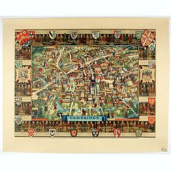
Cambridge.
Though the city had endured significant damage during the Second World War, which ended only a few years prior to publication, there is little indication of the destructi...
- $550 / ≈ €480
Date: London, 1948
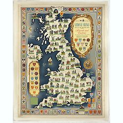
National saving map og the British Isles . . .
A brilliantly eccentric poster showing the festivals, customs of the British Isles with the arms and seals of the counties.Founded in 1861, National Savings is a state-ow...
- $450 / ≈ €393
Date: London, 1951

A map of the British Army with battle honours and militray achievements and Regimental Badges . . .
Shows English County Regiments, Battle Honours and Military Achievements. Bordered by Regimental Badges.A fascinating piece of British history.Read more about Pictorial M...
Date: London, 1952
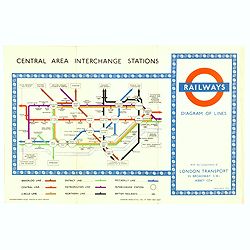
1953 Harry Beck London Underground map.
Published in the Queen's coronation year. A London Underground map (double sided).
- $150 / ≈ €131
Date: London, 1953
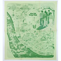
Beatles Map.
A lovely example of the scarce 'Beatles Map' of Liverpool, published in 1974 to commemorate the buildings and places where the Beatles started their stellar careers. The ...
Date: Liverpool, 1974
