Browse Listings in Europe > British Isles > Ireland
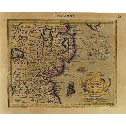
Ultonia Oriental.
Map depicting part of Ulster, with the south-western tip of Scotland in the upper right. From the first French-text edition of Jodocus Hondius' Atlas Minor.Shortly after ...
Date: Amsterdam, 1608

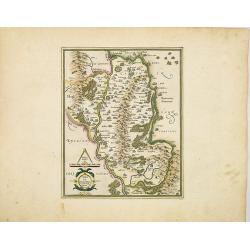
Udrone.
Map depicting present-day County Carlow in Leinster Province & Catherlaugh which is now Carlow. From the first French-text edition of Jodocus Hondius' Atlas Minor.Sho...
Date: Amsterdam, 1608
Udrone Irlandiae in Catherlagh Baronia.
A detailed map of the Barony of Udrone (modern Idrone) in County Carlow, Ireland The title is surrounded by a strapwork design cartouche topped with calipers & a mile...
Date: Amsterdam, 1630

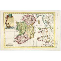
Irlandiae Regnum.
A very nice map from Ireland.Mercator was born in Rupelmonde in Flanders and studied in Louvain under Gemma Frisius, a Dutch writer, astronomer, and mathematician. The ex...
Date: Amsterdam, 1630

.Paskaarte om Achter Yrlandt om te Zeylen van Hitlant tot. . .
An eye-catching chart of Ireland, including the north of England and Scotland, with the West to the top.Pieter Goos (ca. 1616-1675) was one of the most important cartogra...
Date: Amsterdam, 1673
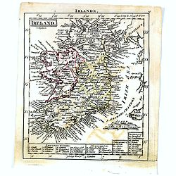
Ireland.
Uncommon miniature map of Ireland, engraved by J. Bayly for "A New General and Universal Atlas Containing Forty five Maps by Andrew Dury".This miniature atlas p...
- $50 / ≈ €44
Date: London, 1761-1763
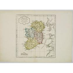
L'Irlande. . .
Map of Ireland, prepared by M. Philippe, embellished with a decorative title cartouche. Engraved by Vallet.
Date: Paris, 1779
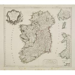
Royaume d'Irelande.. et subdivisé en Comtés.
Finely and crisply engraved map of Ireland.Venetian edition of Giles Didier Robert De Vaugondy's map from Atlas Universel printed in 1776-84.Ornamental title cartouche in...
Date: Venice, 1776 - 1784
L' Irlande.
Map of Ireland. By C. F. Delamarche, successor of Robert de Vaugondy, Geographer.
Date: Paris, 1794 - 1806
