Browse Listings in Europe

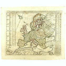
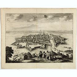
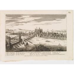
De Haven en Straat von Gibraltar, Niewlyks getekend, en in`t licht gebracht door Johannes Covens en Cornelis Mortier tot Amsterdam.
Decorative map showing the siege of Gibraltar during the Spanish war of succession. This highly interesting map is richly ornated with three additional inset maps and vie...
Date: Amsterdam, 1710
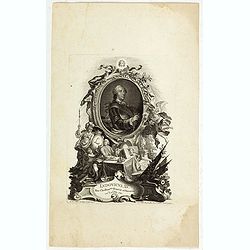
Ludovicus. XV rex chrisitan franciae et navarrae nat d:15. febr. 1710.
Portrait of Ludovicus XV, set in a decorative border.In lower part "Jo. Es. Nilson, inv et excutiv Aug V. et à Paris chez Rosselin Rue St. Jaques a l'Autel Saumur&q...
- $50 / ≈ €42
Date: Augsburg, Paris, 1710
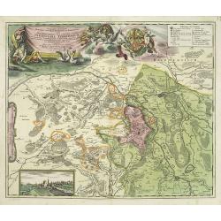
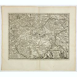
Geographica descriptio Montani cujusdam districtus in ..
Detailed map including the towns of Thurnau, Bayreuth, Culmbach, etc. With fine panoramic view of Thurnau. Upper left and right splendid title cartouches.The map is paint...
Date: Nurenberg, 1710
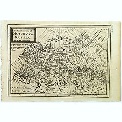
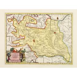
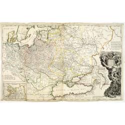
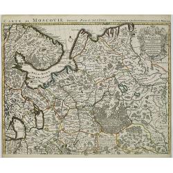
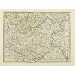
The Dominions of Moscovy or Russia.
A far reaching copperplate map of Russia by the Dutch emigrant Herman Moll. The map extends from Sweden in the west to Tartary and China in the east, to the south both th...
- $110 / ≈ €93
Date: London, 1711
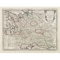
Estats du Grand Duc de Moscovie ou de L'Empereur de la Russie Blanche. . .
The very rare first edition published by Antoine Menard in 1711 in "Le Nouveau et Curieux Atlas géographique et historique.". The map is more commonly found in...
- $500 / ≈ €424
Date: Paris, 1711
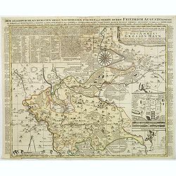
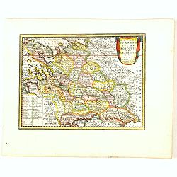
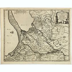
Accurate geographische delineation der in dem Meisnichen creisse des chufurstenthums sachsen liegenden dioeces oder des ammtes grossen hayn
Very detailed map prepared by Adam Frederic Zürner (1680-1742). Surrounded with legends and decorated in the lower right corner with a plan of a royal campement. The tow...
- $90 / ≈ €76
Date: Amsterdam, 1711
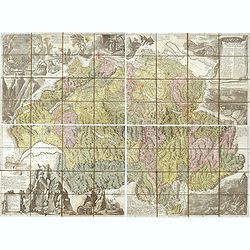
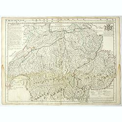
Nova Helvetiae tabula geographica . . .
Johann Jakob Scheuchzer (August 2, 1672 – June 23, 1733) was a Swiss scholar born at Zürich. In 1712 he published, a map of Switzerland in four sheets (scale 1/290,000...
- $1750 / ≈ €1482
Date: Amsterdam, 1712
Carte du Brabant, suivant les Nouvelles Observations de Messrs de L'Academie Royale des Sciences etc. . .
Although not renowned for the originality of his work, Pieter van der Aa is highly thought of for the design and quality of his output. Showing the present-day Dutch and ...
- $300 / ≈ €254
Date: Amsterdam, 1713
Europa In Praecipuas Ipsius Partes Distributa Ad Observation ..
Although not renowned for the originality of his work, Pieter van der Aa is highly thought of for the design and quality of his output. This map of Europe is a good and d...
Date: Amsterdam 1713
L'Utrecht. . .
Although not renowned for the originality of his work, Pieter van der Aa is highly thought of for the design and quality of his output. Showing Dutch province of Utrecht....
Date: Amsterdam, 1713
Carte du cours du Rhin dpuis le fort de Schengen jusqu'à Lauterbourg. . .
Beautiful manuscript map of the region around Rastatt and the siege of 1714 signed with the French emperor Charles VI of Habsburg. In top with a small extension of the ma...
Date: Germany, France, c. 1714
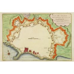
Plan de Palma ville capitalle de l'Isle de Majorque.
Bird's eye-view of Palma de Majorca. Wind rose in the lower left corner. Nicolas de Fer [1646-1720] was one of the most prolific and influential French geographers and ca...
Date: Paris, 1715
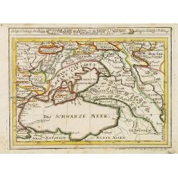
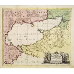
Assoph, Asow, oder Azak mit der Kleinen Tartarey dem Scwharzen Meer. . .
Scarce map showing the Black Sea region with Southern Ukraine, Georgia and Armenia.
- $100 / ≈ €85
Date: Augsburg, 1715
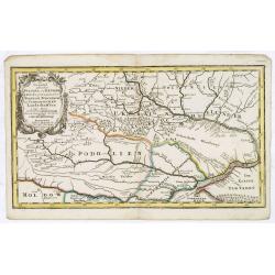
Die Gegend Zwischen Pultava und Bender Mitt Angraenzenden Polnisch, Turckisch und Tartarischen Landschafften.
Scarce map showing central part of the Ukraine with Bjelaja-Zerkow, Poltawa between the Dniester and Dnieper rivers. Black Sea in lower right corner. Detailed with notes,...
- $300 / ≈ €254
Date: Augsburg, 1715
Assoph, Asow, oder Azak mit der Kleinen Tartarey dem Scwharzen Meer. . .
Scarce map showing the Black Sea region with Southern Ukraine, Georgia and Armenia.
- $300 / ≈ €254
Date: Augsburg, 1715
Carte de Suisse ou sont les Cantos de. . .
General map of Switzerland with all the cantons good detail, with the imprint "A Paris Chez l’Auteur sur le Quai de l’Horloge Avec Privilège Aout 1715". In...
Date: Paris, Aout 1715
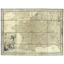
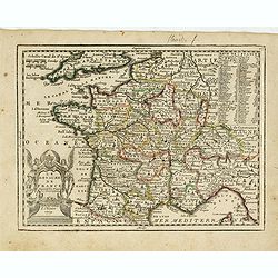
Le Royaume de France avec ses acquisitions ; Divisé en Provinces et en Gouvernemens etc. Dressé sur les Mémoires les plus Nouveaux et Dédié à Louis le Grand Roy de France et de Navarre / par son très Humble serviteur…
Impressive wall map of France decorated with a large figurative title cartouche, a dedication cartouche to the glory of the King of France Louis XIV, and plans of battles...
- $2500 / ≈ €2118
Date: Paris, à présent rue St. Jacques au-dessus de la rue des Mathurins à l'enseigne de la Place des Victoires et du Lion d'Argent, c. 1715
To His Most Serene and August Majesty Peter Alexovitz Absolute Lord of Russia &c. This map of Moscovy, Poland, Little Tartary, and ye Black Sea &c. is most Humbly Dedicated by H. Moll Geographer
Magnificent large-scale, English map of Russia, Ukraine, Poland, Finland and the Baltic Countries and extending south to the Black Sea and the Balkans, with an ornate ded...
Date: London, 1716
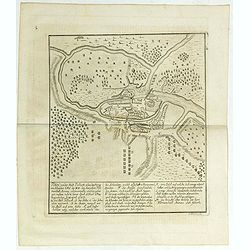
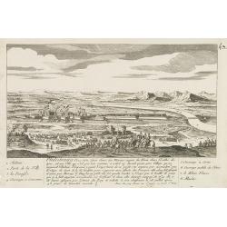
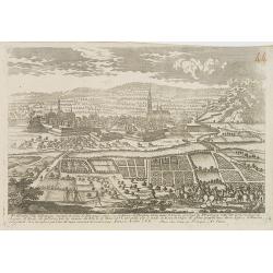
Plan von der Stadt Pullusk alwo der Konig von Sweden Carl XII den Saxischen Feldmarschall Steinau. . .
Rare plan of the Battle of Pultusk which took place on April 21, 1703 in Pultusk during the Great Northern War. The Swedish army under the command of Charles XII defeated...
- $450 / ≈ €381
Date: Frakfurt, Merian heirs,1717

Henna ardera deel. De vijfde Grietenije van de Wester goo. . .
Very detailed map of "Henna ardera deel. De vijfde Grietenije van de Wester goo" in Friesland prepared by Bernardus Schotanus Steringa. With decorative title ca...
Date: Leeuwarden, 1718

Kollumer land En het Nieuw Kruys land de vijfde gritenije van Oostergoo . . .
Very detailed map of "Kollumer land En het Nieuw Kruys land de vijfde gritenije van Oostergoo" in Friesland prepared by Bernardus Schotanus Steringa. Centered o...
Date: Leeuwarden, F. Halma, 1718

Dongerdeel.. De vierde grietenij van Ooster Goo.
Very decorative map centered on Dokkum, Metzerwier, and Pasens from the Uitbeelding der Heerlijkheit Friesland prepared by Schotanus. With decorative title cartouche lowe...
Date: Leeuwarden, F.Halma, 1718

Donger deel.. derde grietenije van Ooster Goo. . .
This is a very decorative map of the area north of Dokkum from the Uitbeelding der Heerlijkheit Friesland prepared by Schotanus. With decorative title cartouche lower rig...
Date: Leeuwarden, F.Halma, 1718

Les Rivieres Kur, et Aras.
View of Aras rivers after Cornelis de Bruyn, from "'Voyages de Corneille le Brun par la Moscovie, en Perse et aux Indes Orientales ...', by Corneille le Brun (Cornel...
- $75 / ≈ €64
Date: Amsterdam, Wetstein, 1718

Over deese grietenije.. Eerste van Wester Goo..
Very decorative map centered on Menaam, Marsum and Boxum from the Uitbeelding der Heerlijkheit Friesland prepared by Schotanus. With ornamental title cartouche lower righ...
Date: Leeuwarden, F.Halma, 1718
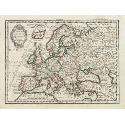
L' Europe Dressée sur les Observations de Mrs. de l' Academie Royale des Sciences..
Charming small map of Europe, including Iceland and the Mediterranean. Based on the geography of Guillaume Delisle.From Le Nouveau et Curieux Atlas Geographique et Histor...
Date: Paris, 1719
![[Lot of 6 plates] Carte de la Laponie Suedoise.](/uploads/cache/36604-250x250.jpg)
[Lot of 6 plates] Carte de la Laponie Suedoise.
Chatelain's map of Lapland (170 x 205mm.) , with views of indigenous people and customs (including Reindeer!), etc.Together with 4 other engraved pages with views of indi...
- $300 / ≈ €254
Date: Amsterdam, 1719
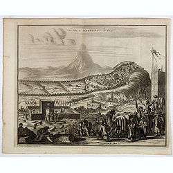
La ville de Berbendt, en Perse.
Decorative view of Derbendt - Derbent, a city in the Republic of Dagestan, Russia, located on the Caspian Sea, north of the Azerbaijani border. It is the southernmost cit...
- $350 / ≈ €296
Date: Leiden, 1719
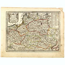
Les Estats de la Couronne de Pologne.
Lovely small map of Poland with title cartouche and a panel in the upper right corner listing local rulers.From Le Nouveau et Curieux Atlas Geographique et Historique.. b...
- $200 / ≈ €169
Date: Paris, 1719
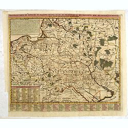
Nouvelle carte du royaume de Pologne, divisée selon..
Chatelain's map of Poland. The title is in two lines across the map. On bottom border appears an index to the map's contents. At the top of the map appear historical rema...
- $750 / ≈ €635
Date: Amsterdam, 1719
Estats du Grand Duc de Moscovie ou de L'Empereur de la Russie Blanche. . .
Lovely small map of central Russia with decorative title cartouche and a panel in the lower left corner listing local rulers.From Le Nouveau et Curieux Atlas Geographique...
- $150 / ≈ €127
Date: Paris, 1719
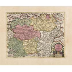
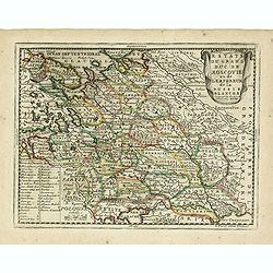
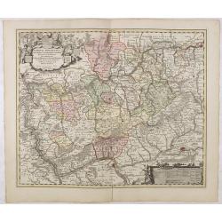
L'Empire D'Allemagne Divisé en ses dix Cercles et Autres Estats. . .
Map centered on Germany, including Poland, Switzerland, Austria, part of France, Northern Italy and Eastern Europe. With title cartouche and a panel in the lower left cor...
- $80 / ≈ €68
Date: Paris, 1719
Le Royaume de France..
Lovely small map of France with decorative title cartouche and a panel in the upper right corner listing local rulers.From Le Nouveau et Curieux Atlas Geographique et His...
- $75 / ≈ €64
Date: Paris, 1719
Estats du Grand Duc de Moscovie ou de L'Empereur de la Russie Blanche. . .
Lovely small map of central Russia with decorative title cartouche and a panel in the lower left corner listing local rulers.From Le Nouveau et Curieux Atlas Geographique...
- $150 / ≈ €127
Date: Paris, 1719
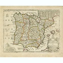
L'Espagne nominée Par les Anciens Grecs Iberia ou Hesperia. . .
Lovely small map of Spain with decorative title cartouche, vessels and a sea monster in the Atlantic Ocean.Presenting a panel in the upper right corner listing local rule...
- $150 / ≈ €127
Date: Paris, 1719
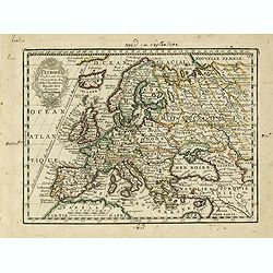
L' Europe Dressée sur les Observations de Mrs. de l' Academie Royale des Sciences..
Charming small map of Europe, including Iceland and the Mediterranean. Based on the geography of Guillaume Delisle.From Le Nouveau et Curieux Atlas Geographique et Histor...
- $150 / ≈ €127
Date: Paris, 1719
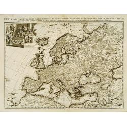
Carte De L'Europe Suivant Les Plus Nouvelles Observations De Messieurs De L'Academie Des Sciences . . .
Includes Iceland, and Russia in the north as well as the Black Sea and the northern tip of Africa in the south. Two tables, listing more than 175 countries along with the...
- $300 / ≈ €254
Date: Amsterdam, 1719
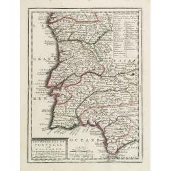
Les Royaumes de Portugal et d'Algarve..
Lovely small map of Portugal showing a panel in the upper right corner with a list of local rulers.From Le Nouveau et Curieux Atlas Geographique et Historique.. by Jacque...
Date: Paris, 1719
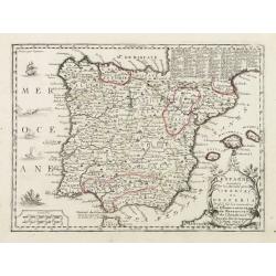
L'Espagne nominée Par les Anciens Grecs Iberia ou Hesperia..
Lovely small map of Spain with decorative title cartouche, vessels and a sea monster in the Atlantic Ocean.Presenting a panel in the upper right corner listing local rule...
Date: Paris, 1719
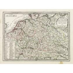
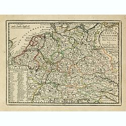
L'Empire D'Allemagne Divisé en ses dix Cercles et Autres Estats..
Map centered on Germany, including Switzerland, Austria, part of France, Northern Italy and Eastern Europe. With title cartouche and a panel in the lower left corner list...
- $60 / ≈ €51
Date: Paris 1719
Terki, ville de la Circassie, dans l'Asie.
A very detailed panoramic view of Terki in the Caucasus, the capital of one of the most powerful Dagestani potentates of southeast Asia.Showing the Volga River.The town o...
Date: Leiden, c. 1719
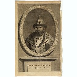
Michael Federowits . . .
Portrait of Tsar Michail Feodorovich (1596-1645). Engraving by Jacob Christopher Sartorius (1694-1737) engraver, active in Nuremberg. This well executed engraving was pub...
- $75 / ≈ €64
Date: Leiden, 1719
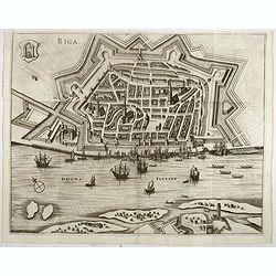
Riga.
Decorative view of Riga. This well executed engraving was published in 1729 and 1727 by Pieter van der AA, in Leiden in "Les Voyages tres-curieux et tres-renommez fa...
Date: Leiden, 1719
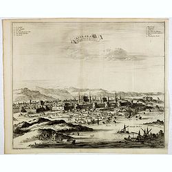
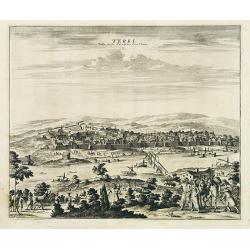
Astrakan, ville capitale du royaume du meme nom, en Moscovie. (Astrakhan)
Decorative view of Astrakhan. Astrakhan is where Europe ends and Central Asia begins. Its position on the Caspian Sea has ensured a long history as an important trading h...
- $300 / ≈ €254
Date: Leiden, 1719
La Moscovie meridionale . . .
Decorative map centred on Moscow. This well executed engraving was published in 1729 and 1727 by Pieter van der AA, in Leiden in "Les Voyages tres-curieux et tres-re...
- $300 / ≈ €254
Date: Leiden, 1719
La Moscovie septentrionale . . .
Decorative view of area north of Moscow. This well-executed engraving was published in 1729 and 1727 by Pieter van der AA, in Leiden in "Les Voyages tres-curieux et ...
- $250 / ≈ €212
Date: Leiden, 1719
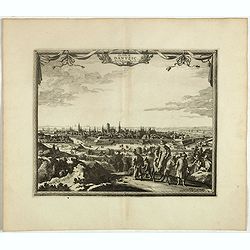
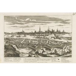
La ville de Dantzic dans la Prusse Royale.
Decorative view of Danzig. This well executed engraving was published in 1719 by Pieter van der AA, in Leiden in "Les Voyages tres-curieux et tres-renommez faits en ...
- $400 / ≈ €339
Date: Leiden, 1719
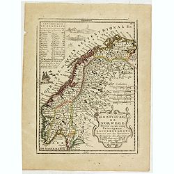
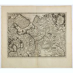
Le Royaume de Norwege Divisé en ses cinq Principaux Gouvernements. . .
Lovely small map of Norway, with much of Sweden to the East, vessel and sea monsters in the Norwegian Sea.It shows a text table in the upper left corner containing the na...
- $100 / ≈ €85
Date: Paris, 1719
Elbing. (Elblag in Northern Poland)
Decorative view of the town of Elblag in Northern Poland. This well executed engraving was published in 1729 and 1727 by Pieter van der AA, in Leiden in "Les Voyages...
- $400 / ≈ €339
Date: Leiden, 1719
Les trois Iles, appellées en Allemand Werders, ou sont les Territoires de Dantzic, Marienbourg et Elbing dans la Prusse Royale avec les Côtes de la Mer Baltique, suivant la description de Olaus Jean Gotho...
Decorative regional map including the town of Danzig and the region south of it. East to the top. This well-executed engraving was published in 1729 and 1727 by Pieter va...
- $450 / ≈ €381
Date: Leiden, 1719
Philisbourg.
A very RARE panoramic view of the city of Philipsburg, including a numbered legend in both lower corners. The plate is numbered in black pencil in the upper right corner....
- $150 / ≈ €127
Date: Paris c.1720
Treves en Allemend Trier.
A very RARE panoramic view of the city of Trier. The plate is numbered in red pencil in the upper right corner.Engraved by Pierre Aveline (Paris, c.1656 - 23 May 1722). H...
- $200 / ≈ €169
Date: Paris, 1690-1720
Ratisbonne.
A very RARE panoramic town view of the city of Ratisbonne, including a numbered legend in both lower corners. The plate is numbered in black pencil in the upper right cor...
- $200 / ≈ €169
Date: Paris c.1720
Breme.
A rare panoramic view of the city of Bremen, including a numbered legend in both lower corners.Published by the brothers Chéreau, active in Paris at rue st.Jacques au Gr...
- $200 / ≈ €169
Date: Paris c.1720
![Malines. [Mechelen]](/uploads/cache/13125-250x250.jpg)
Malines. [Mechelen]
A very RARE panoramic town view of Mechelen, including a numbered legend in the left lower corner.Published by the brothers Chéreau, active in Paris at rue st.Jacques au...
Date: Paris, c.1720
Carte de Moscovie. . .
Centred on Moscow, including Lapland. With fine uncolored title cartouche.
Date: Amsterdam, 1720
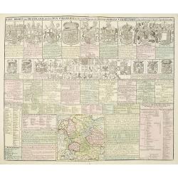
Kort Begryp van Duytsland, de drie Ryx Collegien in hunne Wapens en Zittingen. Kreits Verelingen en Aantekenigen door C. Specht't Utrectht.
Second state of this decorative table of family escutcheons, crests and coats of arms, for various German and Dutch princes and nobles of the 16th, 17th and 18th Centurie...
Date: Amsterdam, 1720
Nassovia Principatus Cum omnibus ei pertinentibus Comitatibus Dominiis ac Praefecturis ut et Confiniis intra Lahnun, Rhenum, et Moenum Flumina, ad situm verum exacte delineatus a Joh. Jac. Stetter. U.J.L. Idstenio-Nassovio . . .
Decorative map of the area between the rivers Rhine and Meuse, including Mainz, Koblenz, Frankfurt, Saarbrucken, etc.Includes an elaborate cartouche and coat of arms.The ...
- $150 / ≈ €127
Date: Amsterdam, 1720
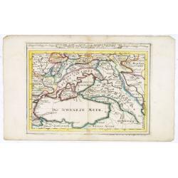
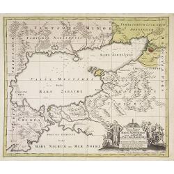
Maris Assoviensis vel de Zabache et Paludis Maeotidis. . .
A very detailed map showing the Black Sea, Azow and Rostow area.
Date: Augsburg, 1720
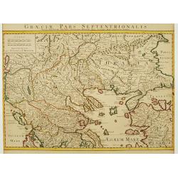
Graeciae Pars Septentrionalis..
Very decorative map illustrating the northern part of Greece and a small part of Turkey. Istanbul is represented on the right margin with its former names Byzantium and C...
Date: Amsterdam, 1720
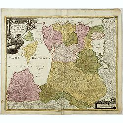
Ducatuum Livoniae et Curlandiae cum vicinis Insulis Nova Exhibitio Geographica. . .
Detailed map of the northern Baltic coast by Homann, pre-dating the privilege.
Date: Nüremberg, 1720
Fribourg Ville d'Allemagne Capitale du païs de Brisgaw.
A very RARE panoramic of the city of Fribourg. The plate is numbered in red pencil in the upper right corner.Engraved by Pierre Aveline (Paris, c.1656 - 23 May 1722). He ...
- $250 / ≈ €212
Date: Paris, 1690-1720
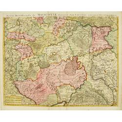
Partie Meridionale de Moscovie. . .
Scarce map centered on Moscow including Azow and part of present-day Ukraine in the bottom part of the map. The map is based on Delisle's important map of the region with...
- $750 / ≈ €635
Date: Amsterdam, 1720
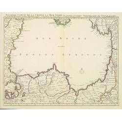
Seconde partie de la Crimee la Mer Noire. . .
The lower part of a set of two maps from the observations of Guillaume Delisle focusing on the Black Sea with wonderful detail of the surrounding regions. Includes Consta...
- $750 / ≈ €635
Date: Amsterdam, 1720
Ausbourg Ville Impériale d'Allemagne dans la Suabe.
A very RARE panoramic of the city of Augsburg. The plate is numbered in red pencil in the upper right corner.Engraved by Pierre Aveline (Paris, c.1656 - 23 May 1722). He ...
- $250 / ≈ €212
Date: Paris, 1690-1720
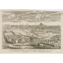
Nuremberg.
A very RARE panoramic view of the city of Nuremberg. The plate is numbered in red pencil in the upper right corner.Engraved by Pierre Aveline (Paris, c.1656 - 23 May 1722...
- $200 / ≈ €169
Date: Paris, 1690-1720
Partie Meridionale de Moscovie..
Centered on Moscow, including Azow in the bottom part of the map.The Amsterdam publishing firm of Covens and Mortier (1721 - c. 1862) was the successor to the extensive p...
- $300 / ≈ €254
Date: Amsterdam 1720
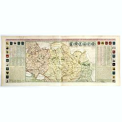
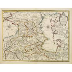
Carte generale des Etats du Czar. Empereur de Moscovie, ou L'on voit ce que ce prince possede en Europe ..
Impressive map of Russia Tartary and part of China with key tables to the towns. Depicting the different states belonging to the Czar in Asia and Europe, showing the path...
- $900 / ≈ €762
Date: Amsterdam, ca. 1720
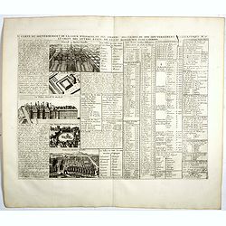
Carte du Gouvernement de la Cour d'Espagne. . .
Engraved text sheet, providing a detailed description of the infrastructure of Spain's ecclesiastical and military government as well as information listed in a lengthy t...
- $75 / ≈ €64
Date: Amsterdam, ca. 1720
![Mayence Mentz en allemand .. [Metz]](/uploads/cache/13109-250x250.jpg)
Mayence Mentz en allemand .. [Metz]
A very RARE panoramic view of the city of Metz, including a numbered legend in the lower corners. The plate is numbered in red pencil in the upper right corner.Engraved b...
- $200 / ≈ €169
Date: Paris 1690-1720
Maris Assoviensis vel de Zabache et Paludis Maeotidis. . .
A very detailed map showing the Black Sea, Azow and Rostow area. With a decorative allegorical cartouche, showing the costumes of the indigenous people of the region.
Date: Augsburg, 1720

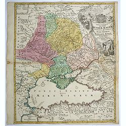
Tabula geographica Russiae Magnae pontus euxinus seu mare nigrum et tauriae regnum. . .
Decorative map of the Black Sea Region, with a large decorative cartouche. Shows Constantinople. Extends north to Moscow and Smolensko.
Date: Nuremberg, 1720
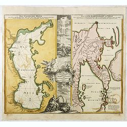
Das Caspische Meer / Das Land Kamtzadalie ...
Two maps on one sheet with the Caspian Sea on one side and northeastern Russia and Kamchatka on the other. The map of the Caspian Sea reflects the survey work of Russia�...
- $450 / ≈ €381
Date: Nuremberg, 1720

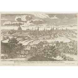
Amsterdam Capitale de la Hollande.
A panoramic of Amsterdam seen from 't IJ. Set within a decorative border, printed from a separate plate. Rare.
Date: Leiden, 1720
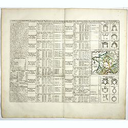
Carte du Gouvernement Ecclesiastique de France Divise en ses Archeveschez, Eveschez, Archidiaconnez, Archipretrez, Doyennez, et Parroisses.
This impressive plate provides a comprehensive list of the ecclesiastical divisions in the country with their corresponding coats of arms. A small inset map depicts the l...
- $55 / ≈ €47
Date: Amsterdam, 1720
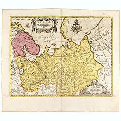
Russiae vulgo Moscovia dictae, Partes Septentrionalis. . .
In the north the Murmansk Sea. Including the western coast of Nova Zembla. Title cartouche and two cartouches, the bottom right one showing two hunters, bears, stags etc....
Date: Amsterdam, 1720
Carte des Pays voisins de la Mer Caspiene. . .
A most attractive and detailed map of the region between the Black and Caspian Seas after De L'Isle. The two Seas are decorated with compass roses. This is one of the few...
Date: Amsterdam, 1720

Nostre Dame de Lorette.
A very RARE panoramic of Lorette and the church, including a numbered legend in both lower corners.The plate is numbered in black pencil in upper right corner.Published ...
Date: Paris c.1720
Tabula geographica qua pars Russiae Magnae..
A detailed map of western Russia, depicting the Ukraine, the Black sea, Turkey to the south, Romania and Bulgaria to the south west, Georgia to the east. Shows the cities...
Date: Nuremberg, 1720
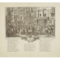
Rue Quinquempoix en l'année 1720. De regte afbeelding der wind negotie gehouden in de straat van Quinquempoix tot Parys.
A true picture of the wind trade of the rue Quinquempoix, Paris, in 1720, taken from "Het groote tafereel der dwaasheid : vertoonende de opkomst, voortgang en onderg...
Date: Amsterdam, 1720