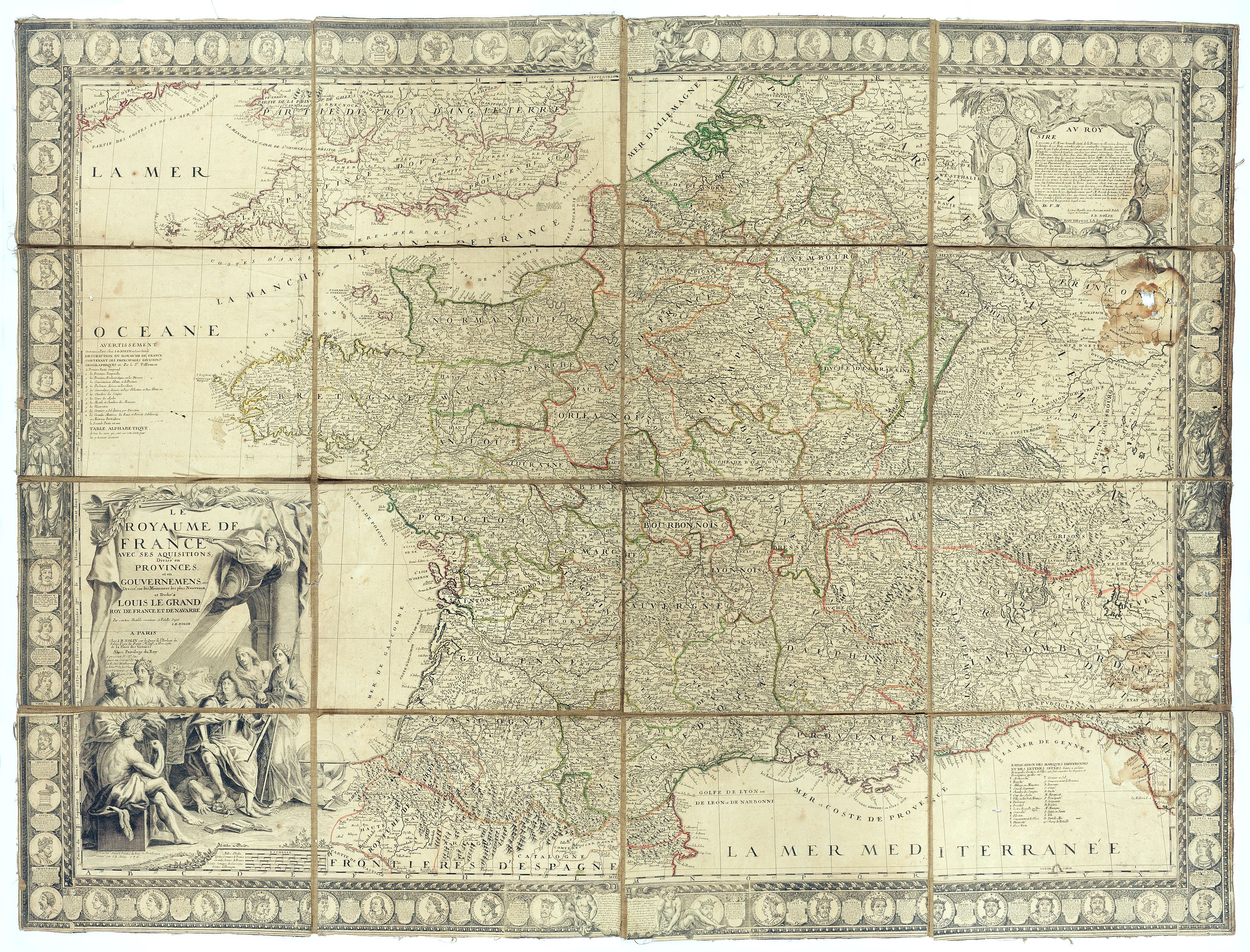
Le Royaume de France avec ses acquisitions ; Divisé en Provinces et en Gouvernemens etc. Dressé sur les Mémoires les plus Nouveaux et Dédié à Louis le Grand Roy de France et de Navarre / par son très Humble serviteur… |
||||||||||||||||||||
|
||||||||||||||||||||
|
|
||||||||||||||||||||
This item is available for immediate sale
2500.00
|
My Collection +
Add this or any of your favorite items in one place. If you want to save the items permanently, you have to sign in or create an account first. |
|||||||||||||||||||
Description
Impressive wall map of France decorated with a large figurative title cartouche, a dedication cartouche to the glory of the King of France Louis XIV, and plans of battles won by Louis XIV: "Conquestes du Roy depuis la ligue d'Ausbourg 1686" (king's conquests since the league of Augsburg 1686); the map is surrounded by portraits of all the Kings of France from Pharamond to Louis XV.
Title cartouche with the imprint "A Paris Chez J.B. Nolin sur le Quay de l'Horloge du Palais, Vers le Pont Neuf, a l'enseigne de la Place des Victoires Avec privilege du Roy à présent R. St. Jacques au-dessus de la rue des Mathurins à l'enseigne de la Place des Victoires et du Lion d'Argent". The cartouche has been drawn by Arnoud painter to the King and engraved by J.B. Nolin.
The symbolism of the title cartouche: Louis XIV seated, crushing Medusa with his foot, with a woman at his side who may represent Minerva, goddess of reason and temporal power. Behind, another woman holds the chalice, a symbol of the Christian religion. Behind, sun rays dazzle characters, symbolizing the fear of God and reinforcing the idea of the king as a divine and enlightened figure. The scene is surmounted by a Renommée with 2 trumpets. On the left, a seated Hercules with a lion's skin symbolizes strength. Standing to the king's right, a woman crowned with laurels presents a map, which could be England. At the bottom right of the cartouche are a globe and a painter's palette, making Louis XIV a protector of science and arts).
The decorative border including the kings' dynasty up to louis XV, has been separately engraved and added to the map. The King's portraits are mostly engraved after those of the "Cabinet du Roy". Louis XV is represented as a child with a text glorifying him and the Royalty, perhaps at the time of the Regency.
We have not been able to locate any example of this map surrounded by this border.
Jean-Baptiste Nolin is the name of both father and son (père ca. 1657–1708, fils 1686–1762) engravers (Nolin père graveur du roi), cartographers and booksellers. Nolin père drew heavily on the maps of Coronelli and of Jean-Nicholas de Tralage (alias Sieur de Tillemon), but the beauty and scope of his maps are genuine achievements. After the death of the elder Nolin, the younger continued to update, publish and sell the splendid maps from the family publishing-house-cum-bookshop on the Quai de l’Horloge, where other major cartographers (de Fer, de l’Isle, du Val et al.) set up shop on the north coast of the Île de la Cité in Paris.
Louis XV, known as Louis the Beloved, was King of France from 1 September 1715 until he died in 1774. He succeeded his great-grandfather Louis XIV at the age of five. Until he reached maturity in 1723, the kingdom was ruled by his grand-uncle Philippe II, Duke of Orléans, as Regent of France.
FAQ - Guarantee - Shipping
994 BuyBidBuying in the BuyNow Gallery
This item is available for immediate purchase when a "Add to Cart" or "Inquire Now" button is shown.
Payments are accepted in Euros or US Dollars. We accept most major credit cards, PayPal and bank transfer.
Authenticity Guarantee
 We provide professional descriptions, condition report and HiBCoR rating (based on 45 years experience in the map business)
We fully guarantee the authenticity of items we sell. We provide a certificate of authenticity for each purchased item.
Condition / Coloring
We indicate the condition of each item and use our unnique HiBCoR grading system in which four key items determine a map's value: Historical Importance, Beauty, Condition/Coloring and Rarity.
We offer many maps in their original black and white condition. We do not systematically color-up maps to make them more sellable to the general public or buyer.
Copper engraved or wood block maps are always hand colored. Maps were initially colored for aesthetic reasons and to improve readability. Nowadays, it is becoming a challenge to find maps in their original colors and are therefor more valuable.
We use the following color keys in our catalog:
Original colors; mean that the colors have been applied around the time the map was issued.
Colored; If the colors are applied recently or at the end of the 20th century, then "colored", or "attractive colors" will be used.
Original o/l colors; means the map has only the borders colored at the time of publication.
Read more about coloring of maps [+]
FAQ
Please have a look for more information about buying in the BuyNow gallery.
Many answers are likely to find in the general help section.
My Collection+
![]()
With My Collection+ you can collect all your favorite items in one place. It is free, and anyone can create his or her virtual map collection.
Unless you are logged in, the item is only saved for this session. You have to be registed and logged-in if you want to save this item permanently to My Collection+.
Read More [+]
If you want to save the items permanently, please sign in
or create account first. ![]()
Registering Here, it is and you do not need a credit card.
Add this item to
My Collection+
or click the following link to see My Collection+.
Invoice
The invoice and certificates of authenticity are available in the client center >Invoices
| Digital Image Download | |
|
Paulus Swaen maintains an archive of most of our high-resolution rare maps, prints, posters and medieval manuscript scans. We make them freely available for download and study. Read more about free image download |
Click the image for a free small image download. |
In accordance with the EU Consumer Rights Directive and habitually reside in the European Union you have the right to cancel the contract for the purchase of a lot, without giving any reason.
The cancellation period will expire 14 calendar days from the day after the date on which you or a third party (other than the carrier and indicated by you) acquires, physical possession of the lot. To exercise the right to cancel you must inform Paulus Swaen Inc, of your decision to cancel this contract by a clear statement (e.g. a letter sent by post, or e-mail.
To meet the cancellation deadline, it is sufficient for you to send your communication concerning your exercise of the right to cancel before the cancellation period has expired.
