Featured Listings in World Maps

Secunda etas mundi. Folium XIII.
Schedel's world map was based on the cartographic system of Claudius Ptolemy, the great second-century AD geographer whose scholarship formed the foundation for map produ...
Date: Nuremberg, 12 July 1493
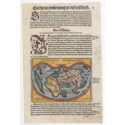
Universalis Cosmographia.
A very desirable cordiform (heart-shaped) world map from Johann Honter's 'Rudimentum'. The map is a reduced version of Waldseemüller's and Apianus' earlier world maps. T...
Date: Zurich, Froschauer, ca. 1546/1548
Benedict. Arias Montanus Sacrae Geographiae Tabulam Ex Antiq
THE EXTREMELY RARE FIRST STATE landmark world map, famed for its depiction of the Australian landmass.One of the earliest printed maps to depict the “terra incognita�...
Date: Anvers 1571 /1572
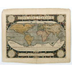
Typus Orbis Terrarum.
Ortelius' third and last world map is dated 1587 under the author's signature. The earlier border of clouds has been replaced by a more intricate and elegant lattice of s...
Date: Antwerp, 1592/1601

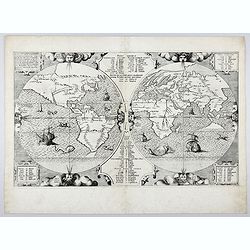
Orbis Terrae Compendiosa Descriptio.
Gerard Mercator's great world map of 1569 was condensed into double hemispherical form by his son Rumold. It first appeared in 1587 in Casaubon's edition of Strabo's Geog...
Date: Amsterdam, 1595-1609
![Summa philosophiae quadripartita, de rebus dialecticis, moralibus et metaphysicis . . [ With unrecorded world map ]](/uploads/cache/28639-250x250.jpg)
Summa philosophiae quadripartita, de rebus dialecticis, moralibus et metaphysicis . . [ With unrecorded world map ]
On page 107 a finely copper engraved world map (88x84mm.) Paradigma Terrae Plagas 4.ac 12. Ventorum situm indicans., centered on Europe and Africa, with parts of America,...
Date: Leiden, Peter Rigaud, 1626
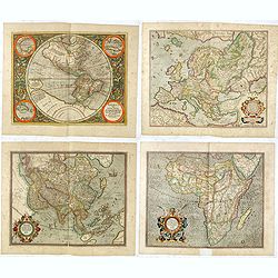
Set of four continents.
Fine set of 4 continents prepared by Gerard Mercator. The general map of Europe, as well as Americae Pars, Greenland, Iceland, a Polar landmass, along with the mythical i...
Date: Amsterdam, 1628

Nova Totius Terrarum Orbis Geographica..
The first of four states of the map. French text on verso. One of the most beautiful world maps ever engraved and one of the most influential in promulgating the Californ...
Date: Amsterdam, 1630-1633

Nouvelle et exacte description du globe terrestre reveue corrigée et augmente´e suivant les derniéres relations des Anglais et Hollandois. Par Guillaume Blaeu 1645.
Extremely rare and decorative "carte a figures" world map published by Anthoine de Fer. The double hemisphere world map is surrounded by constellations of the A...
Date: Paris, 1645
![Carte de L'Amerique… / Carte Nouvelle de L'Europe Asie & Afrique… [Two sheets]](/uploads/cache/49267-250x250.jpg)
Carte de L'Amerique… / Carte Nouvelle de L'Europe Asie & Afrique… [Two sheets]
Rare. Two hemispheres printed on two sheets. A single decorative cartouche on each carries the title concluding with the imprint recorded above, and around each hemispher...
Date: Paris, 1661

Nova Totius Terrarum Orbis Geographica ac Hydrographica Tabula.
A beautifully decorative world map taken from the 'English Atlas' by Moses Pitt and Steven Swart, based on an earlier engraved world map by Pieter van den Keere ca. 1630,...
Date: Oxford, 1680

Nova Orbis Tabula in Lucem edita A.F.de Wit.
According to Shirley, De Wit's map is one of the most attractive of its time. The brilliant scenes in the corners combine images of the four seasons, the elements, and th...
Date: Amsterdam, 1680

Nansenbushu bankoku shoka no zu.
This wall-map is a great example of Japanese world maps representing Buddhist cosmology with real-world cartography. It is the earliest one and - therefore - the prototyp...
Date: Kyoto, (Hoei 7 = Year of the Tiger) 1710

A new and correct map of the world.
The early eighteenth century was one of the most important periods for English cartography. One of the period's most intriguing world maps is this large-scale map, which ...
Date: London 1714
![[World and 4 continents] Carte Geographique Astronomique Chronologique et Historique du Monde.](/uploads/cache/63024-250x250.jpg)
[World and 4 continents] Carte Geographique Astronomique Chronologique et Historique du Monde.
French wall map of the world in 4 sheets published by Crépy "à l'entrée du Cloistre de St. Benoist du côté des maturins". A decorative wall map of the worl...
Date: Paris, 1720-1735
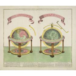
GLOBUS TERRESTRIS ad sphaeram obliquam delineatus. and the GLOBUS COELESTIS cum Astrodictico artificiali iunctus.
A very handsome, large copper engraving of a pair of globes. Ribbon style titles and German text panel at bottom.
Date: Augsburg, 1774

Nouvelle Mappa Monde.
State 2 of this fine double hemisphere world map, from an unusual perspective, with a "Mer de L'Ouest" or "Sea of the West". Paris is located at the c...
Date: Venice, 1776 - 1784
Index Geographicus Tum veteristum novae cognitae Terrae. . .
This rare and decorative advertising poster uses the world map by Presbyter Chrysanthos, who was the Patriarch of Jerusalem. In the top we see John Constantine Bessaraba ...
Date: Paris, ca. 1930

World Flight Routes (all in Japanese).
A large, very decorative Japanese world map published as sugoroku (a Japanese game which might be compared to backgammon), published as a supplement to the 1930 New Year�...
Date: Osaka, 1930
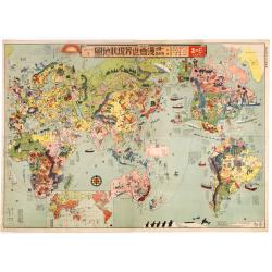
Japanese Stereotype Map of the World from 1932 Share Hitome de wakaru Manga sekai genjō chizu. At a glance: Cartoon Map of the Current World Situation. 目でわかる 漫画世界現状地圖
An extraordinary satirical map of the world was seen through Japanese eyes in the early 1930s as Japanese imperial ambitions strengthened. The map was published as an edi...
Date: Tokyo, Showa 7, or 1932

Carriers of the New Black Plague.
A powerful satirical commentary on totalitarian control of speech from the first issue of Ken Magazine. "Caught here in all their peculiar beauty by the soul searchi...
Date: Chicago, 1938
![[Magazine including pictorial world map, Carriers of the New Black Plague by William Cotton.]](/uploads/cache/43680-250x250.jpg)
[Magazine including pictorial world map, Carriers of the New Black Plague by William Cotton.]
Front cover with color illustration of a Moroccan male sheik and yellow lettering.Oversized magazine, features analysis of English justice, map of Herr Hitler's heaven (f...
Date: Chicago, April 7th, Vol.1 No.1 1938

Carte de la Charte de L'Antique . . .
The rare French version of this decorative pictorial world map by MacDonald Gill. "This magnificent map drawn up while the Second World War still raged is already en...
Date: London, Alf Cooke Ltd, 1943
![Les Forbans [Board game]](/uploads/cache/49165-250x250.jpg)
Les Forbans [Board game]
Game board designed by Lucien Boucher, without any randomness, which is rare for that time. The board which is cut in four parts show a world map drawn by Lucien Boucher....
Date: Paris, Perceval, ca. 1950

(World map). Americus Vespucio novo te Duce Ducta Freto Ambivi Meritoqs Vocor.
Manuscript world map showing the American and African continent and the southern parts of Asia. In the Indian Ocean a large depiction of Amerigo Vespucci 1454 – 1512) o...
Date: Italy, ca. 1954
![Air France [poster].](/uploads/cache/44299-250x250.jpg)
Air France [poster].
A superb double-sided Air France folding poster, featuring bold colored graphics. Published as a serious piece of marketing put out by the airline showing off their state...
Date: Paris, 1955
