Browse Listings

Paraguay, Chili, Terre Magellan ?
Map of Paraguay, Chili, and Argentina . By C. F. Delamarche, successor of Robert de Vaugondy, Geographer.
Date: Paris, 1794 -1806
![Morokoshi Meisho Zue [Illustrated Description of Famous Sites of China].](/uploads/cache/34118-250x250.jpg)
Morokoshi Meisho Zue [Illustrated Description of Famous Sites of China].
Published in Osaka, Kawachiya Genhichiro, et al. [8 book sellers], slightly later issue but apparently in Edo period, using all the same woodblocks of original first edit...
Date: Osaka, Edo, slightly later than Bunka 3, year of the tiger - 1806

Siberie ou Russie Asiatique, Tartarie Chinoise, Pays des Eluts et Isles du Japon.
Map of the Kamchatka peninsula, Russian Far East., Korea, Japan, with Hokkaido labeled "Terre del Jeso".By C. F. Delamarche, successor of Robert de Vaugondy, Ge...
Date: Paris, 1794 - 1806
![[Beatles]](/uploads/cache/49038-250x250.jpg)
[Beatles]
Plate III from Carl Gustav Jablonsky and J.F.W. Herbst: "Natursystem aller bekannten in- und ausländischen Insecten", engraved by Bodenehr. Carl Gustav Jablons...
Date: Berlin, J. Pauli, 1785-1806

Asia.
Uncommon map of Asia. Engraved by Marco di Pietro.The map is of interest for the use of G. di Corea, for the sea between Korea and Japan.Published by Carlo Antonio Barbie...
Date: Milan, 1807

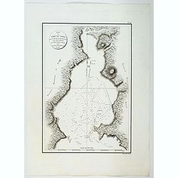
Plan de la Baie de L'Adventure. . .
A French maritime chart of Adventure Bay in S.E. Tasmania. Adventure Bay is the name of both a township and a geographical feature on the eastern side of Bruny Island. Th...
Date: Paris, ca 1807

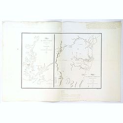
Plan du Port du Sud de la Baie de la Recherche / Croquis de la Baie des Moules. . .
A French maritime chart of the Port du Sud in Research Bay and the mouth of the Bay of Mussels, both in southern Tasmania. This is the edition of the extremely rare atlas...
Date: Paris, ca 1807
Plan du Port du Nord de la Baie de la Recherche.
A French maritime chart of the plan of the northern portion of Recherche Bay on the S.E. tip of Tasmania. The chart has some physical detail, outlining trees and hills, b...
Date: Paris, ca 1807
Plan du Port Jackson / Plan du Comte de Cumberland.
Two maps on one sheet showing the earliest scientific surveys of Port Jackson and the area surrounding Sydney Harbour, undertaken by the French in 1802. This is the editi...
Date: Paris, 1807
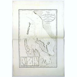
Carte de la Baie des Chiens-Marins (Shark's Bay de Dampier). . .
A strikingly detailed chart of a portion of the coastline of Western Australia, titled 'Carte de la Baie des Chiens-Marins, which William Dampier also explored. The chart...
Date: Paris, 1807

Plan de L'Isle de Paque / Plan de la Baie de Cook.
Two engraved maps and four coastal profiles of Easter Island in the Pacific. First published in the Atlas du Voyage de la Perouse. This is the edition of the extremely ra...
Date: Paris, 1797-1807

Carte de L'Archipel de La Recherche a la partie Occidentale de la Terre de Nuyts. . .
A large and detailed chart of the southern West Australian coast centered on the region of Esperance and the surrounding islands.Terre de Nuyts is the name that was forme...
Date: Paris 1807
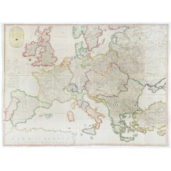
(Post Roads of Europe) Neueste Allgemeine Postkarte von Europa in welcher samtliche Postrouten aller europaischen Staaten nach den zuverlässigsten Postbüchern. . .
The largest postal map of Europe, published in Vienna in the midst of the Napoleonic Wars. This postal map of Europe first appeared in 1798 and is considered one of the e...
Date: Vienna, 1807

Carte Réduite Du Golphe Du Mexique Et Des Isles De L' Amérique..
A well engraved and highly detailed chart prepared by Bellin of the Gulf of Mexico and the Caribbean. In addition to a magnificent title cartouche and a color key to the ...
Date: Paris dated year 17, or 1808
![Boats of the Friendly Islands. [together with] A Sailing Canoe of Otaheite.](/uploads/cache/30041-250x250.jpg)
Boats of the Friendly Islands. [together with] A Sailing Canoe of Otaheite.
Early view of Queen charlotte's sound, taken from "Views in the South Seas" being a very important and early views depicting scenes encountered while employed a...
Date: London, Boydell and Co., 1808

View of the harbour of Taloo, in the island of Eimeo.
John Webber View of the Harbour of Taloo on Moorea (Society Islands), from "Views in the South Seas" being a very important and early views depicting scenes enc...
Date: London, Boydell and Co., 1808
![A Toopapaoo of a Chief, with a priest making his offering to the Morai, in Huoheine. [Huaheine - the Society Islands]](/uploads/cache/30045-250x250.jpg)
A Toopapaoo of a Chief, with a priest making his offering to the Morai, in Huoheine. [Huaheine - the Society Islands]
A view of a chief's raised burial chamber in Huaheine, Society Islands, taken from "Views in the South Seas" being a very important and early view depicting sce...
Date: London, Boydell and Co., 1808

The Narta, or Sledge for burdens in Kamtschatka.
Webber's view of transport in Kamtchatka, Russia, showing the sledge dogs hooked up to the sledge, and their master on skis, taken from "Views in the South Seas"...
Date: London, Boydell and Co., 1808
![View in the island of Cracatoa. [Rakata in the Sunda Strait]](/uploads/cache/30051-250x250.jpg)
View in the island of Cracatoa. [Rakata in the Sunda Strait]
Early view of the volcano Krakatoa (Indonesian name: Krakatau), on the Indonesian island of Rakata in the Sunda Strait, taken from "Views in the South Seas" bei...
Date: London, Boydell and Co., 1808

The Fan palm, in the island of Cracatoa.
The Fan palm, on the island of Krakatoa (Indonesian name: Krakatau), in the Sunda Strait, taken from "Views in the South Seas" being a very important and early ...
Date: London, Boydell and Co., 1808
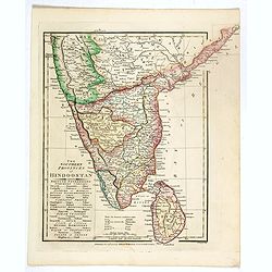
The Southern provinces of Hindoostan . . .
An attractive map showing Hindoostan and Ceylon. Shows towns, rivers, mountains, lakes, etc. In pretty original wash colors. Robert Wilkinson was active in London as a ca...
Date: London, 1808

Karte vom Koenigreiche Ungarn mit Einschluss der Königreiche Kroazien und Slavonien dann von dem Grossfürstenthume Siebenbürgen.
Wall map of the Kingdom of Hungary in 8 sheets mounted on canvas, preserved in their original case. The map has a graduated margin and is enclosed in a simple yet decorat...
Date: Vienna, 1809
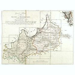
(Index sheet) General Tableau zur Karte von Alt Ost und West Preussen nebst dem aufgenommenen Trigonometrischen Netz. . .
Index sheet of this important multi-sheet map of Prussia, Lithuania, and Poland.Section XXIV of the rare first edition of this important 25-sheet map prepared by Friedric...
Date: Berlin, 1802-1810
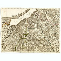
(Sheet X with Puk Bay from) General Tableau zur Karte von Alt Ost und West Preussen nebst dem aufgenommenen Trigonometrischen Netz. . .
Sheet IV with Zalew Wislany and the towns of Elblag, Paslek, Braniewo, etc, of this important multi-sheet map of Prussia, Lithuania, and Poland.The rare first edition of ...
Date: Berlin, 1802-1810
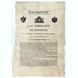
Par Brevets. / Eau admirable de Cologne, de A. Farina, ancien Distillateur de Cologne, breveté, Place Juliers, N°11.
Advertising Broadsheet promoting the toilet water "Eau de Cologne". Ornated with the royal coat of arms of France and 2 two-headed eagles. With the printed sign...
Date: After 1810
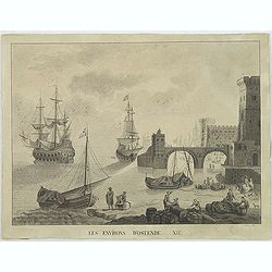
Les environs d'Ostende. XII.
Beautiful view of Oostende. A somewhat fanciful depiction of the harbor of Oostende, with merchant on the foreground and large vessels in the sea. The item is signed (Dre...
Date: Belgium, c. 1811

Carte von West=Gallizien welche auf allerhöchsten Befehl Seiner Kaiserlich oesterreichischen und Königlich apostolischen Majestät in den Jahren 1801 bis 1804. . .
Important early map of Western Galicia, as given to Austria by the third Partition of Poland (1795). Due to its lengthy development period, a rare map rich in detail depi...
Date: Vienna, (1808) after 1811
![[Title page] Voyage de découvertes aux terres Australes éxécuté par ordre de S.M l'Empereur et Roi.](/uploads/cache/39732-250x250.jpg)
[Title page] Voyage de découvertes aux terres Australes éxécuté par ordre de S.M l'Empereur et Roi.
Set of two title pages from the atlas part of "Voyage de decouvertes aux terres australes", Freycinet and Peron's accounts of the French cartographic expedition...
Date: Paris, Langois, 1811
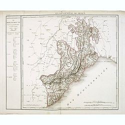
Département de Montenotte Divisé en 4 arrondissemens et en 30 cantons.
Published in the "Atlas National de France" at Chanlaire. Engraved by P.A.F. Tardieu. Represents the department of Apennines which was under French administrati...
Date: Paris, 1790-1811
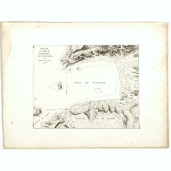
Esquisse de la Baie de Coupang (cote S.O. Ile de Timor) par M. M. Peron et Lesueur, an 1803.
Map of Kupang Bay on the Indonesian Island Timor, prepared by Louis Freycinet during his voyage under Captain Thomas Baudin in 1800-1803. Plate no. 14 from the atlas part...
Date: Paris, Langois, 1811

Charte von China und den angränzenden Ländern und Völkerschaften so wie den letzten Kaiser Tschien-Long. . .
Uncommon map of China on a scale of ca. 1:6,000,000. The map's complete title is “Charte von China und den angränzenden Ländern, und Völkerschaften so wie sie dem le...
Date: Parague, 1812
Selling price: ????
Please login to see price!
Sold in 2023
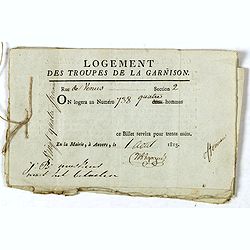
Logement des troupes de la garnison. . .
Seven coupons "Logement des troupes de la garnison ce billet servira pour trente nuits" giving a soldier the right for housing at 738 Rue de Venus in Antwerp in...
Date: Antwerp, 1813
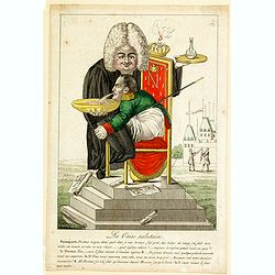
La Crise salutaire.
In this` fine French caricature we see Napoleon seated in side profile to the left on an ornate chair-commode, clasping his knees, benign forward to vomit into a bowl hel...
Date: Paris, 1814
![Hindostan [India]](/uploads/cache/49208-250x250.jpg)
Hindostan [India]
A fine copper engraved map of Hindoostan (now India) drawn and engraved by Alexander Findlay and published by Thomas Kelly, London in 1814
Date: London, 1814
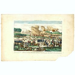
Bataille de la Moskwa Remportée par l'Armée Française le 7 Septembre 1812...
Uncommon print showing the siege of Moscow on September 7, 1812 by Napoleon Bonaparte.Jean was a well-known publisher of optical prints and other popular prints, establis...
Date: Paris, ca. 1815
![Generalkarte vom Königreich Preussen u. d. Herz[ogtum] Warschau nach astronomischen Ortsbestim[m]ungen und geodätischen Messungen. . .](/uploads/cache/37060-250x250.jpg)
Generalkarte vom Königreich Preussen u. d. Herz[ogtum] Warschau nach astronomischen Ortsbestim[m]ungen und geodätischen Messungen. . .
Rare seemingly unrecorded map of Poland with its borders after the Congress of Vienna, probably based on a lost first edition of Daniel Friedrich Sotzmann's (1754-1840) m...
Date: Nuremberg, Schneider & Weigel 1815

Corea and Japan.
A fine large-scale map of Japan and Korea showing an increasingly refined outline to the Japanese islands but still oversized Korean peninsula. The strait south of Korea,...
Date: Edinburgh, 1816
Grand atlas universel ou collection de cartes encyprotypes, générales et détaillées des cinq parties du monde.
Large folio atlas containing 8 general one-sheet maps, and 8 detailed four-sheet maps: Containing2 World maps- "Mappe-monde sur la projection de Mercator. Carte ency...
Date: Paris, Desray, 1816
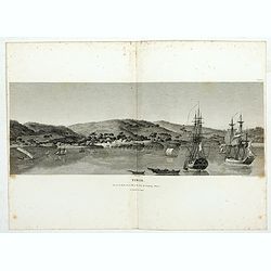
Timor. Vue de la rade, de la ville et du fort de Coupang, dans l'île de Timor.
Nice double page view of the town Kupang, formerly known as Koepang. In the center is the Dutch V.O.C. fort. From Voyage de découvertes aux terres Australes by François...
Date: Paris, 1807-1816
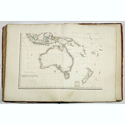
![[Title page] Voyage de découvertes aux terres Australes . . . Deuxieme partie.](/uploads/cache/46363-250x250.jpg)
[Title page] Voyage de découvertes aux terres Australes . . . Deuxieme partie.
Title page of the atlas Voyage de découvertes aux terres Australes by François Péron, 1824. The French expedition under Nicolas Baudin, was commissioned to chart the c...
Date: Paris, 1807-1816

Woman of Brabant.
Very fine view of a woman wearing the traditional dress of Brabant.
Date: London, 1817
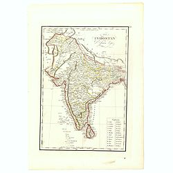
El Indostan por D. Juan Lopez.
Uncommon map of India and Shri Lanka published by Juan Lopez (1765-1830) and included in his "Atlas Universal o collection de mapas nuevos. . ." first published...
Date: Madrid, 1817

Langley's New Travelling and Commercial Map . . .
A highly desirable, detailed and uncommon map of England and Wales, published by Langley and Belch. The map is flanked by a pair of large and detailed explanation tables,...
Date: London, 1817
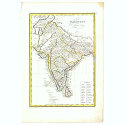
El Indostan por D. Juan Lopez.
Uncommon map of India and Shri Lanka published by Juan Lopez (1765-1830) and included in his "Atlas Universal o collection de mapas nuevos. . ." first published...
Date: Madrid, 1817
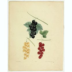
Black, Dutch Red and White Current.
Color aquatint and stipple engraved plate of fruits by George Brookshaw (1751-1823) from his "Pomona Britannica; or, a Collection of the most esteemed fruits at pres...
Date: London, Bensley and son, 1817
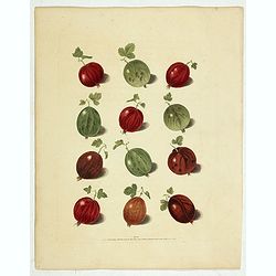
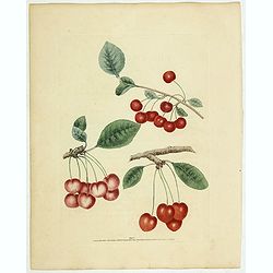
Cherries.
Color aquatint and stipple engraved plate of fruits by George Brookshaw (1751-1823) from his "Pomona Britannica; or, a Collection of the most esteemed fruits at pres...
Date: London, Bensley and son, 1817
Cherries.
Color aquatint and stipple engraved plate of fruits by George Brookshaw (1751-1823) from his "Pomona Britannica; or, a Collection of the most esteemed fruits at pres...
Date: London, Bensley and son, 1817

Account of a voyage of discovery to the west coast of Corea.
BRITAIN'S FIRST ACCURATE ACCOUNT OF KOREA & OKINAWANS. With an appendix containing charts and various hydrographical and scientific notices by captain Basil Hall and ...
Date: London, 1818
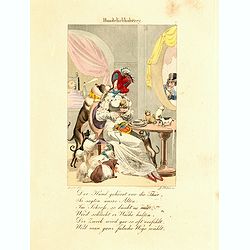
Hundeliebhaberey.
Engraved by Joseph Stöber, (born in Vienna 13. June 1768, died 12 March 1852) after design of Matthäus Loder (1781-1828). From Castelli, "Zerrbilder menschlicher T...
Date: Wien, 1818
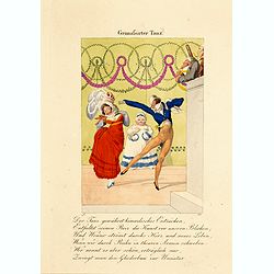
Grimafsirter Tanz.
Engraved by Joseph Stöber, (born in Vienna 13. June 1768, died 12 March 1852) after design of Matthäus Loder (1781-1828). From Castelli, "Zerrbilder menschlicher T...
Date: Wien, 1818
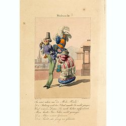
Modesucht.
Engraved by Joseph Stöber, (born in Vienna 13. June 1768, died 12 March 1852) after design of Matthäus Loder (1781-1828). From Castelli, "Zerrbilder menschlicher T...
Date: Wien, 1818
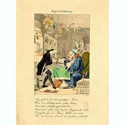
Vogel Liebhaberey.
Engraved by Joseph Stöber, (born in Vienna 13. June 1768, died 12 March 1852) after design of Matthäus Loder (1781-1828). From Castelli, "Zerrbilder menschlicher T...
Date: Wien, 1818
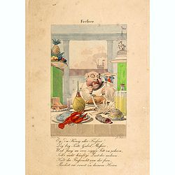
Frefser.
Engraved by Joseph Stöber, (born in Vienna 13. June 1768, died 12 March 1852) after design of Matthäus Loder (1781-1828). From Castelli, "Zerrbilder menschlicher T...
Date: Wien, 1818
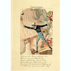
Schmetterlingsfang.
Engraved by Joseph Stöber, (born in Vienna 13. June 1768, died 12 March 1852) after design of Matthäus Loder (1781-1828). From Castelli, "Zerrbilder menschlicher T...
Date: Wien, 1818
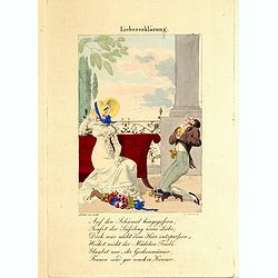
Liebeserklärung.
Engraved by Joseph Stöber, (born in Vienna 13. June 1768, died 12 March 1852) after design of Matthäus Loder (1781-1828). From Castelli, "Zerrbilder menschlicher T...
Date: Wien, 1818
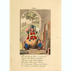
Säufer.
Engraved by Joseph Stöber, (born in Vienna 13. June 1768, died 12 March 1852) after design of Matthäus Loder (1781-1828). From Castelli, "Zerrbilder menschlicher T...
Date: Wien, 1818
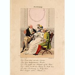
Zerstreuung.
Engraved by Joseph Stöber, (born in Vienna 13. June 1768, died 12 March 1852) after design of Matthäus Loder (1781-1828). From Castelli, "Zerrbilder menschlicher T...
Date: Wien, 1818
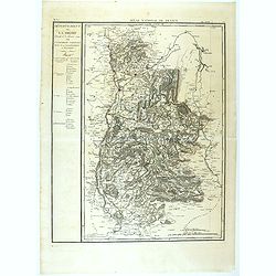
Département de la Drome decreté le 3 février 1790. . .
Map of the region of southeast France. The region of Drome is divided into four districts. On the left, the title with underneath a large explicative text with the divisi...
Date: Paris, 1790-1818

Voyage of his majesty’s ship Alceste, along the Coast of Corea, to the island of Lewchew, with an account of her subsequent shipwreck, by John M’LEOD. Surgeon of the Alceste.
The second and best edition, with a frontispiece portrait of Captain Maxwell and five fine hand-colored aquatint plates, including a plate not present in the first editio...
Date: London, John Murray, 1818
Portulano de la Ameririca Setentrional construido en la direccion de tabajos.
The "Portulano de la America Setentrional", is an exceedingly rare Spanish sea atlas featuring charts of the Caribbean and the Gulf of Mexico. It was developed ...
Date: Madrid, 1818

Cary's New Terrestrial Globe Exhibiting The Tracks and Discoveries made by Captain Cook; Als...
An early Regency 21-inch terrestrial globe CARY, John and William. - Cary's New Terrestrial Globe Exhibiting The Tracks and Discoveries made by Captain Cook; Also those o...
Date: London, 1815/1818

Carte d'Afrique Dressée pour l'instruction par Guillaume DeLisle. . .
The map is a rare re-issue of the Delisle map of 1722. In his first map of the continent in 1700, Delisle re-measured the Mediterranean, being the first to establish its ...
Date: Paris, J.Dezauche, 1819
![Etats-Unis de L'Amerique Septentrionale. [Two sheets in manuscript ]](/uploads/cache/03972-250x250.jpg)
Etats-Unis de L'Amerique Septentrionale. [Two sheets in manuscript ]
Two sheets giving detailed information in French about the population in 1810, principal cities, products of industry and commerce, the financial situation for 1818, etc....
Date: France, ca. 1819

Vue de Gattweick et de l'embouchure du Rhin, dans la Mer du Nord.
Very decorative view of Katwijk. Signed lower right, Louis Bleuler au chateau de Laufen . Original design by Louis Bleuer. This gouache was the model for his aquatint in ...
Date: 1820

Chungguk-do
Chungguk-do [Map of China] taken from a Korean printed Ch’onha chido [Atlas of all under Heaven] which is a 19th century version of the traditional Korean atlas produce...
Date: Korea, ca. 1820

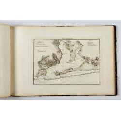
Manuscript plan of Havana harbour.
Manuscript chart with good nautical detail and soundings of Havana harbour.
Date: Spain c.1820

Carte générale de l' Amérique divisée en ses principaux états . . .
Map of North and South America. By C. F. Delamarche, successor of Robert de Vaugondy, Geographer. Descriptive text to the left.
Date: Paris, 1820

Carte de l'Arabie d'après les différents morceaux qu'a donnés M. Niebuh...
Detailed map of the Arabian Peninsula, after Niebuhr, with scales in the lower left corner. Engraved by Pierre-Paul Dubuisson.More about Mapping of Arabia [+]
Date: Paris, ca. 1820
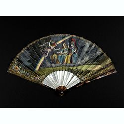
Very fine folding fan with painting of Minerva, Juno and 2 peacocks.
Small folding fan made of double skin sheet, mounted in English style, painted with gouache and depicting Minerva and Juno sitting near each other and receiving the visit...
Date: ca. 1820
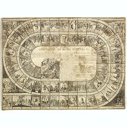
Jeu Royal de la vie d'Henri IV.
Large sheet with an animated Goose-game of 63 numbered squares, spiral, counterclockwise, centripetal focused on the French king Henri IV.André Basset offers the life of...
Date: Paris, ca. 1816-1820
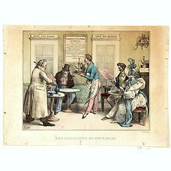
Les Jouissance du Juste Milieu.
[The Joys of the Happy Medium.] A waiter is about to serve a customer with a clyster pump and water jug. It looks as though the man has a 'menu' in one hand. On another t...
Date: Paris, ca 1820
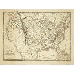
Carte Generale des Etats-Unis De L'Amerique Septentionale . . .
One of the earliest obtainable maps to show the United States From Coast to Coast, published in Paris by A.H. Brue.The map is especially interesting west of the Mississip...
Date: Paris, 1820
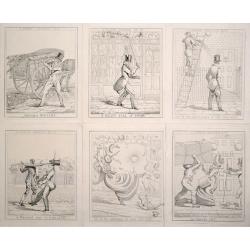
(Complete set of 6) A London Nuisance.
Scarce and amusing series of 6 plates depicting the dangers of the London streets.Complete set of 6 "A London Nuisance", etchings by Richard Dighton, plates 1-6...
Date: London, 1821

London in Miniature With The Surrounding Villages. An Entire New Plan In which the Improvements both present and intended are actually reduced, by permission, from the surveys of the Several Proprietors. . .
Hand-coloured engraved map, dissected and mounted on linen, orange publishers label on one side, extending west to east from Kensington to East India and Greenwich Dock a...
Date: London, 1821
![[ First Separate Map of Michigan Territory ] Geographical, statistical, and historical map of Michigan territory.](/uploads/cache/25931-250x250.jpg)
[ First Separate Map of Michigan Territory ] Geographical, statistical, and historical map of Michigan territory.
The map illustrates Michigan Territory and the so-called "Indian Line" shortly after the Treaty of Chicago (1821), the third of three treaties with the Native A...
Date: Philadelphia, 1822
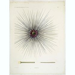
Oursins.
Decorative plate of a sea urchin, engraved by Boquet. Marie Jules César Lelorgne de Savigny (April 5, 1777 - October 5, 1851) was a French zoologist. In 1798 he traveled...
Date: Paris, 1822
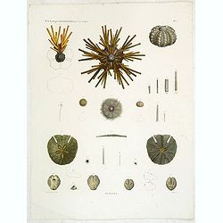
Oursins.
Showing sand dollars, sea urchin, etc. engraved by Macret. Marie Jules César Lelorgne de Savigny (April 5, 1777 - October 5, 1851) was a French zoologist. In 1798 he tra...
Date: Paris, 1822
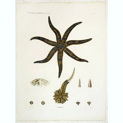
Astéries.
Decorative engraving of a star fish, engraved by Boquet. Marie Jules César Lelorgne de Savigny (April 5, 1777 - October 5, 1851) was a French zoologist. In 1798 he trave...
Date: Paris, 1822
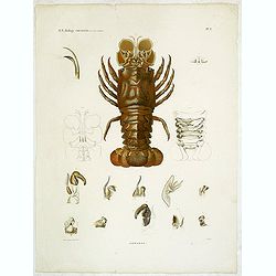
Hommards.
Decorative engraving of a lobster, by Tresca. Marie Jules César Lelorgne de Savigny (April 5, 1777 - October 5, 1851) was a French zoologist. In 1798 he traveled to Egyp...
Date: Paris, 1822
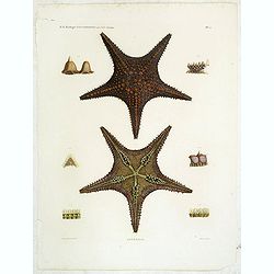
Astéries.
Decorative engraving of star fishes, by Macret and Leleu. Marie Jules César Lelorgne de Savigny (April 5, 1777 - October 5, 1851) was a French zoologist. In 1798 he trav...
Date: Paris, 1822

