Jeu Royal de la vie d'Henri IV. |
||||||||||||||||||||
|
||||||||||||||||||||
|
|
||||||||||||||||||||
$750 / ≈ €655This item is available for immediate sale! Questions before Buying ?
We are happy to answer your questions.
750.00
|
My Collection +
Add this or any of your favorite items in one place. If you want to save the items permanently, you have to sign in or create an account first. |
|||||||||||||||||||
Description
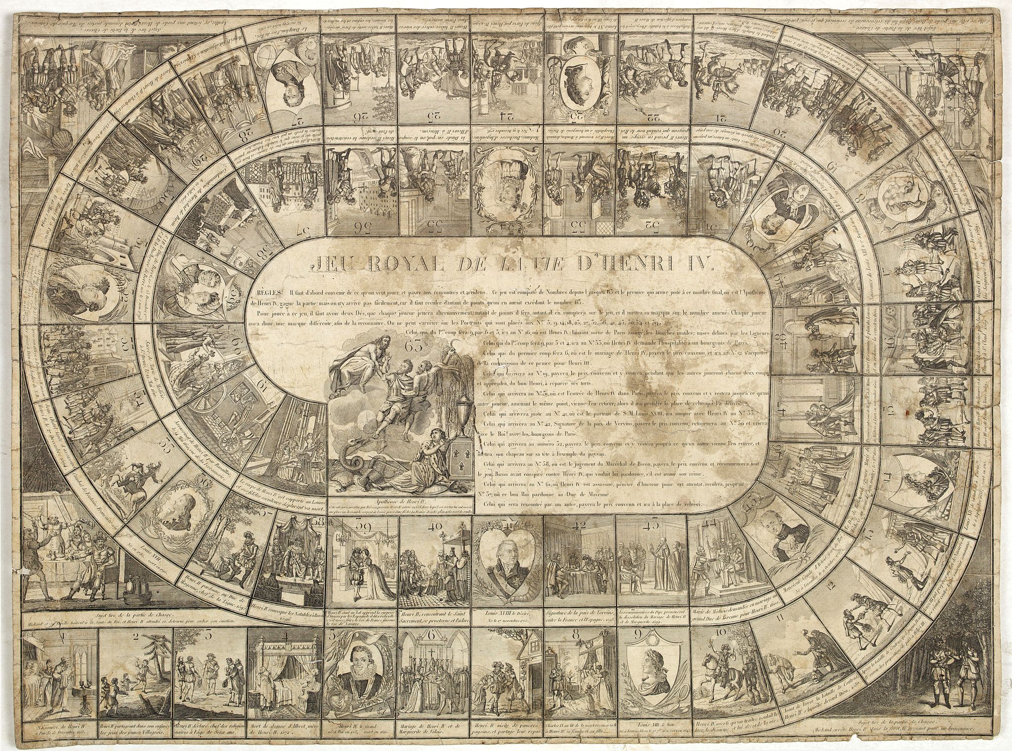
Large sheet with an animated Goose-game of 63 numbered squares, spiral, counterclockwise, centripetal focused on the French king Henri IV.
André Basset offers the life of Henri IV in pictures, from his birth to his apotheosis. The route is constructed chronologically, punctuated by political events, marriages, battles and peace.
It shows a sovereign, close to his people and merciful, sharing the meal of poor peasants (n ° 7), letting out of besieged Paris women, children and the elderly (n ° 26), welcoming a peasant from Béarn charged cheese from his country (n ° 51). The "historic" comments have their own box, "rally to my panache" (n ° 20), to the wish to see "the least laborer put the chicken in the pot every Sunday" (n ° 57).
The sovereign restorer of civil peace prevails over the memory of religious dissension: no trace of Saint Barthélemy behind the marriage to Marguerite de Valois (n ° 6). The medals of the members of the royal family, placed on the huts of the geese, constitute a family portrait that makes the Bourbons the "sons of Henry IV" and prepares the succession of Charles X, younger brother of Louis XVIII.
The double portrait of the Duke and Duchess of Berry dates the engraving between 1816 and 1820, the date of the assassination of the Duke (n ° 59).
More about game boards [+]
FAQ - Guarantee - Shipping
Buying in the BuyNow Gallery
This item is available for immediate purchase when a "Add to Cart" or "Inquire Now" button is shown.
Items are sold in the EU margin scheme
Payments are accepted in Euros or US Dollars.
Authenticity Guarantee
 We provide professional descriptions, condition report (based on 45 years experience in the map business)
Paulus Swaen warrants the authenticity of our items and a certificate of authenticity is provided for each acquired lot.
Condition and Coloring
We indicate the condition of each item and use our unnique HiBCoR grading system in which four key items determine a map's value: Historical Importance, Beauty, Condition/Coloring and Rarity.
Color Key
We offer many maps in their original black and white condition. We do not systematically color-up maps to make them more sellable to the general public or buyer.
Copper engraved or wood block maps are always hand colored. Maps were initially colored for aesthetic reasons and to improve readability. Nowadays, it is becoming a challenge to find maps in their original colors and are therefor more valuable.
We use the following color keys in our catalog:
Original colors; mean that the colors have been applied around the time the map was issued.
Original o/l colors; means the map has only the borders colored at the time of publication.
Colored; If the colors are applied recently or at the end of the 20th century.
Read more about coloring of maps [+]
Shipping fee
A flat shipping fee of $ 30 is added to each shipment by DHL within Europe and North America. This covers : International Priority shipping, Packing and Insurance (up to the invoice amount).
Shipments to Asia are $ 40 and rest of the world $50
We charge only one shipping fee when you have been successful on multiple items or when you want to combine gallery and auction purchases.
Read more about invoicing and shipping
FAQ
Please have a look for more information about buying in the BuyNow gallery
Many answers are likely to find in the general help section.
My Collection+
![]()
With My Collection+ you can collect all your favorite items in one place. It is free, and anyone can create his or her virtual collection.
Unless you are logged in, the item is only saved for this session. You have to be registed and logged-in if you want to save this item permanently to My Collection+.
Read More[+]
Register here, it is free and you do not need a credit card.
Add this item to
My Collection+
or click the following link to see My Collection+.
| Digital Image Download | |
|
Paulus Swaen maintains an archive of most of our high-resolution rare maps, prints, posters and medieval manuscript scans. We make them freely available for download and study. Read more about free image download |
Click the image for a free small image download. |
In accordance with the EU Consumer Rights Directive and habitually reside in the European Union you have the right to cancel the contract for the purchase of a lot, without giving any reason.
The cancellation period will expire 14 calendar days from the day after the date on which you or a third party (other than the carrier and indicated by you) acquires, physical possession of the lot. To exercise the right to cancel you must inform Paulus Swaen Inc, of your decision to cancel this contract by a clear statement (e.g. a letter sent by post, or e-mail.
To meet the cancellation deadline, it is sufficient for you to send your communication concerning your exercise of the right to cancel before the cancellation period has expired.
