Browse Listings
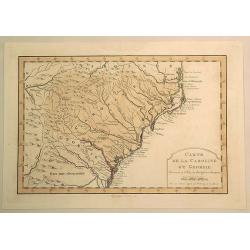
Carte de la Caroline et Georgie.
Fine hand-colored Bellin atlas map of the Southern States Georgia and Carolina from Curriluk Pass to Kekil Island. Out of "Atlas Portalif ". A plain title carto...
Date: Paris, 1773
Selling price: ????
Please login to see price!
Sold in 2020
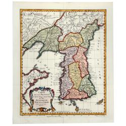
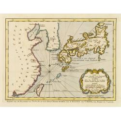
CARTE DE LA PROVINCE de Quan-tong ou Lyau-tong et du ROYAUME DE KAU-LI ou COREE (Korea).
An uncommon issue of this fine map of Korea. The map is of interest for the use of East Sea, the sea between Korea and Japan, here called "Mer de Corée". With ...
Date: Paris, 1749-1773
Selling price: ????
Please login to see price!
Sold in 2019
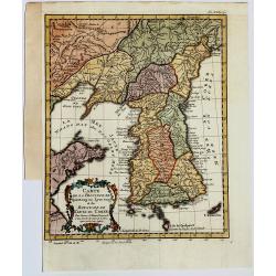
Carte de la Province de Quantong ou Lyau tong et du Royaume de KAU-LI ou COREE
Uncommon issue of this fine map of Korea. The map is of interest for the use of East Sea, the sea between Korea and Japan, here called "Mer de Corée.Decorative titl...
Date: Paris, 1749-1773
Selling price: ????
Please login to see price!
Sold in 2019
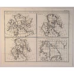
Carte Qui Represente les Differentes Connoissances que Lion Eues des Terres Arctiques. . .
This magnificent original copper-plate engraved antique maps of 4 different time based views of Hudsons Bay & Eastern Canada by Robert De Vaugondy was engraved in 177...
Date: Paris, 1773
Selling price: ????
Please login to see price!
Sold in 2020
![Vue de la Riviere d'Endeavour sur la Cote de la Nouvelle Hollande ou le Vaisseau fut mis a la bande. [Tome IV Pl. 1ere.]](/uploads/cache/45540-250x250.jpg)
Vue de la Riviere d'Endeavour sur la Cote de la Nouvelle Hollande ou le Vaisseau fut mis a la bande. [Tome IV Pl. 1ere.]
The first known landscape drawing of the east coast of Australia. A View of the Endeavour River, on the coast of New Holland, where the ship was laid on shore, in order t...
Date: Paris, 1773
Selling price: ????
Please login to see price!
Sold in 2021
![[A set of 6 Astronomical copperplate engravings].](/uploads/cache/45926-250x250.jpg)
[A set of 6 Astronomical copperplate engravings].
A set of 6 engravings by J. Mynde from "Ferguson's "Astronomy Explained upon Sir Isaac Newton's Principles. ."[Plate 1] 'The Solar System'.[Plate 2] 'The T...
Date: London, ca 1773
Selling price: ????
Please login to see price!
Sold in 2020
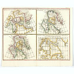
Carte qui represente les différentes connoissances que l'on a eues des Terres Arctiques depuis 1650 jusqu'en 1747. . .
A fascinating group of four maps on the one sheet to illustrate the cartography of Sanson in 1750, Delisle in 1700 and 1703 plus that of the famous Arctic explorer Henry ...
Date: Paris, 1773
Selling price: ????
Please login to see price!
Sold in 2020
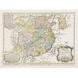
L'Empire de La Chine pour servir a l'histoire des etablissemens europees ..
Attractive map of China with Canton, Nanking and Taiwan, called Isle Tay-wan, ou de Formosa.The map is of interest for the use of East Sea, the sea between Korea and Japa...
Date: The Hague, 1773
Selling price: ????
Please login to see price!
Sold
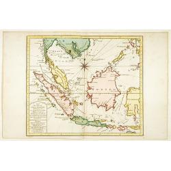
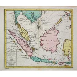
Carte des Isles de Java Sumatra et Borneo..
A very fine map centered on the islands of Java, Sumatra, Borneo and Malay Peninsular.With French text in title cartouche and an additional title in Dutch below.
Date: Amsterdam 1773
Selling price: ????
Please login to see price!
Sold
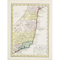
Suite du Bresil ..
Uncommon edition of this accurate map of part of Brazil.From Atlas Portatif pour servir a l'intelligence de l'Histoire Philosophique et Politique des etablissements et du...
Date: Amsterdam, 1773
Selling price: ????
Please login to see price!
Sold in 2016
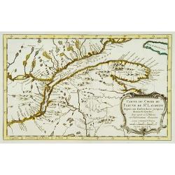
Carte du cours du Fleuve de St.Laurent..
Uncommon edition of this accurate map showing the lower St.Laurence. Second state.From Atlas Portatif pour servir a l'intelligence de l'Histoire Philosophique et Politiqu...
Date: Amsterdam 1773
Selling price: ????
Please login to see price!
Sold
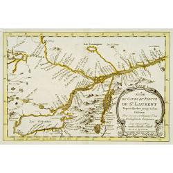
Suite du cours du Fleuve de St.Laurent..
Uncommon edition of this accurate map showing the lower the upper St.Laurence. Second state. From Atlas Portatif pour servir a l'intelligence de l'Histoire Philosophique ...
Date: Amsterdam, 1773
Selling price: ????
Please login to see price!
Sold in 2013
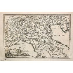
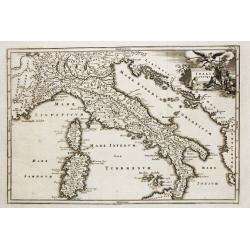
Gallia Cisalpina.
Christoforus Cellearius (1638-1707), geographer. Geographia Antiqua, 1686-1812, Notitia orbis antiquis sive geographia plenior, 1703.A map of northern Italy. From "N...
Date: Leipzig, 1773
Selling price: ????
Please login to see price!
Sold
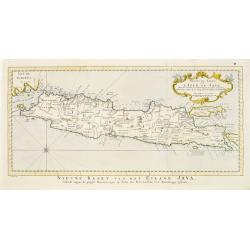
Nouvelle carte de l'Isle de Java.
A very nice map centered on the island of Java.With French text in title cartouche and an additional title in Dutch underneath the map.
Date: Amsterdam 1773
Selling price: ????
Please login to see price!
Sold
Carte des Isles du Japon.. Coree, Avec .. De la Chine..
Uncommon map of Japan, Korea, Taiwan and the south east coast of China from Peking till Macao. After J.N.Bellin, with title in Dutch in lower margin, engraved by J.van Sc...
Date: Amsterdam 1773
Selling price: ????
Please login to see price!
Sold
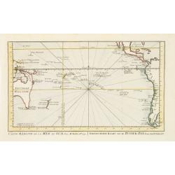
Carte réduite de la Mer du Sud.. Gereduceerde kaart van de Zuider-zee..
Intriguing map of the Pacific. Partial outline of Australia, Nouvelle Zeelande, Nouvelle Guinee, North America and the west coast of South America. With title in French a...
Date: Amsterdam 1773
Selling price: ????
Please login to see price!
Sold
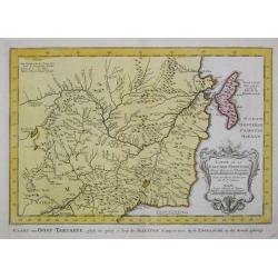
Carte de la Tartarie Occidentale.
Jaques Nicolas Bellin (1702-720) was the most important French hydrographer of the 18th century. Sea-atlas 'Hydrographique Français' , 1756-65, atlas to accompany Prévo...
Date: Amsterdam, 1773
Selling price: ????
Please login to see price!
Sold in 2009
Carte de l' Indoustan...
Nicolas Bellin's map of Pakistan and northern India. Uncommon Dutch issue, with text in French and Dutch. Engraved by J.van Schley. From "Atlas Portatif pour servir ...
Date: The Hague, 1773
Selling price: ????
Please login to see price!
Sold in 2020
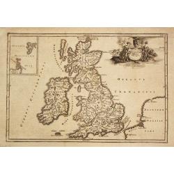
Insularum Britannicarum Facies Antiqua.
Christoforus Cellearius (1638-1707), geographer. ' Geographia Antiqua', 1686-1812
Date: Leipzig, 1773
Selling price: ????
Please login to see price!
Sold in 2008
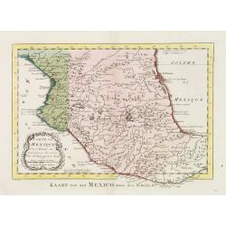
Carte du Mexique.
Uncommon edition of this fine map of Mexico.From Atlas Portatif pour servir a l'intelligence de l'Histoire Philosophique et Politique des etablissements et du commerce de...
Date: Amsterdam, 1773
Selling price: ????
Please login to see price!
Sold
Carte des Isles de Java, Sumatra Borneo & Les Détroits de la Sonde Malaca et Banca Golphe de Siam.
Jaques Nicolas Bellin (1702-720) was the most important French hydrographer of the 18th century. Sea-atlas 'Hydrographique Français' , 1756-65, atlas to accompany Prévo...
Date: Amsterdam, 1773
Selling price: ????
Please login to see price!
Sold in 2016
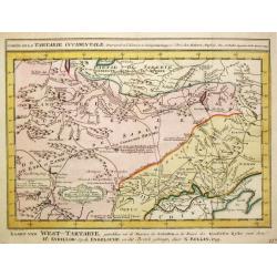
Carte de la Tartarie Occidentale.
Jaques Nicolas Bellin (1702-720) was the most important French hydrographer of the 18th century. Sea-atlas 'Hydrographique Français' , 1756-65, atlas to accompany Prévo...
Date: Amsterdam, 1773
Selling price: ????
Please login to see price!
Sold in 2009
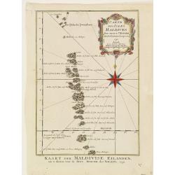
Carte des isles Maldives.
Jaques Nicolas Bellin (1702-720) was the most important French hydrographer of the 18th century. Sea-atlas 'Hydrographique Français' , 1756-65, atlas to accompany Prévo...
Date: Amsterdam, 1773
Selling price: ????
Please login to see price!
Sold
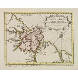
Carte de L'Isle de Caiene et de ses environs.
Uncommon edition of this accurate map of Cayenne.From Atlas Portatif pour servir a l'intelligence de l'Histoire Philosophique et Politique des etablissements et du commer...
Date: Amsterdam, 1773
Selling price: ????
Please login to see price!
Sold in 2022
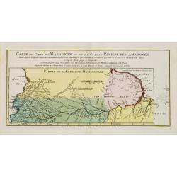
Carte du Cours du Maragnon ou .. Amazones..
Uncommon edition of this map of the river Amazon.From Atlas Portatif pour servir a l'intelligence de l'Histoire Philosophique et Politique des etablissements et du commer...
Date: Amsterdam, 1773
Selling price: ????
Please login to see price!
Sold in 2018
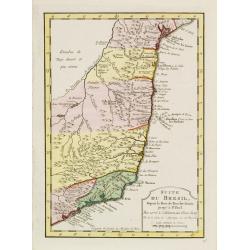
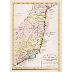
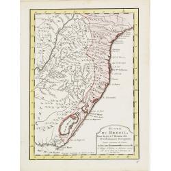
Suite du Bresil Depuis la Baie de Tous les Saints..
Uncommon edition of this accurate map of part of Brazil, from San Salvador till Rio de Janeiro and S.Paulo.From Atlas Portatif pour servir a l\'intelligence de l\'Histoir...
Date: Amsterdam, 1773
Selling price: ????
Please login to see price!
Sold in 2008
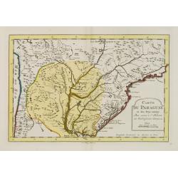
Carte du Paraguay et des Pays voisins..
Uncommon edition of this fine map of Paraguay.From Atlas Portatif pour servir a l'intelligence de l'Histoire Philosophique et Politique des etablissements et du commerce ...
Date: Amsterdam, 1773
Selling price: ????
Please login to see price!
Sold in 2017
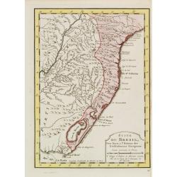
Suite du Bresil ..
Uncommon edition of this accurate map of part of Brazil.From Atlas Portatif pour servir a l\'intelligence de l\'Histoire Philosophique et Politique des etablissements et ...
Date: Amsterdam 1773
Selling price: ????
Please login to see price!
Sold in 2008
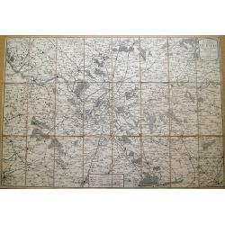
Carte des environs de Paris, suivant les nouvelles observations par J. Laurent,...
Highly detailed map of Paris and environs printed by Mondhare. Includes many small villages which are now actually within the Paris city limits... Extends from Vernon an...
Date: Paris, 1773
Selling price: ????
Please login to see price!
Sold in 2013
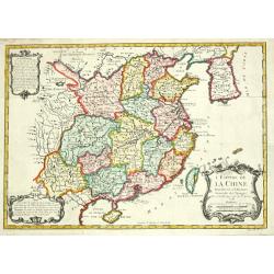
L' Empire de la Chine, 1748.
Jaques Nicolas Bellin (1702-720) was the most important French hydrographer of the 18th century. Sea-atlas 'Hydrographique Français' , 1756-65, atlas to accompany Prévo...
Date: Amsterdam, 1773
Selling price: ????
Please login to see price!
Sold
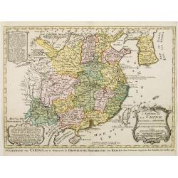
L'Empire de La Chine../ 't Keizerryk van China..
Attractive map of China with Korea and Taiwan (I.Tay-wan, ou Formosa). Decorative title cartouches in three corners.From Atlas Portatif pour servir a l'intelligence de l'...
Date: Amsterdam 1773
Selling price: ????
Please login to see price!
Sold
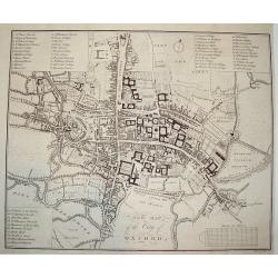
NEW MAP OF THE CITY OF OXFORD
A scarce 18th century plan of the City of Oxford. The work is finely rendered and contains exceptional detail. Three separate legends identify important town sites. Unive...
Date: London, dated 1773
Selling price: ????
Please login to see price!
Sold
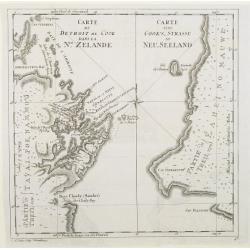
Carte du detroit de Cook dans la Nle. Zelande. Carte von Cook's-Strasse in Neu-Seeland
Showing Cook Strait in New Zealand. Engraved by D.A.Hauer.
Date: Nuremberg, 1773
Selling price: ????
Please login to see price!
Sold
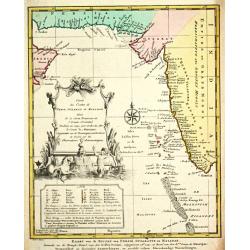
Carte des Costes de Perse, Guzarat et Malabar.
Jaques Nicolas Bellin (1702-720) was the most important French hydrographer of the 18th century. Sea-atlas 'Hydrographique Français' , 1756-65, atlas to accompany Prévo...
Date: Amsterdam, 1773
Selling price: ????
Please login to see price!
Sold in 2018
Italia Antiqua.
Christoforus Cellearius (1638-1707), geographer. ' Geographia Antiqua', 1686-1812
Date: Leipzig, 1773
Selling price: ????
Please login to see price!
Sold
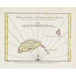
Carte des Isles de Madere et Porto Santo.
An uncommon issue of this very nice map of the Island of Madera and Porto Santo.With French text in title cartouche and an additional title in Dutch underneath the map.
Date: Amsterdam, 1773
Selling price: ????
Please login to see price!
Sold
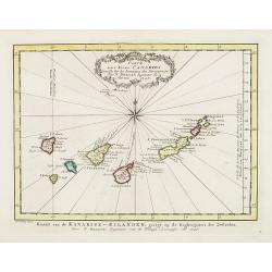
Carte des Isles Canaries dressee sur les Journaux des navigateurs. . .
Uncommon edition of this fine map of the Canaries.In lower right engraved "3."From Atlas Portatif pour servir a l'intelligence de l'Histoire Philosophique et Po...
Date: Amsterdam, 1773
Selling price: ????
Please login to see price!
Sold in 2012
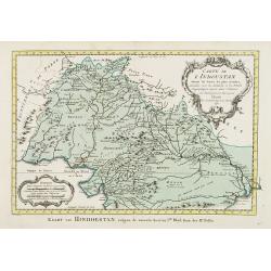
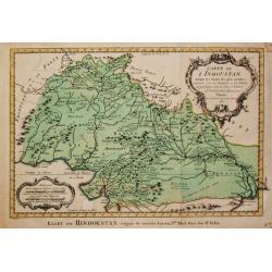
Carte de L'Indoustan. . .
Uncommon edition of this fine map of the northern part of India. In lower right engraved "4a"From Atlas Portatif pour servir a l'intelligence de l'Histoire Phil...
Date: Amsterdam, 1773
Selling price: ????
Please login to see price!
Sold in 2013
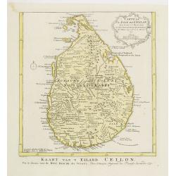
Carte de L'Isle de Ceylan. Pour servir à l'histoire. . .
Uncommon edition of this fine map of Shri Lanka. In lower right engraved "6."From Atlas Portatif pour servir a l'intelligence de l'Histoire Philosophique et Pol...
Date: Amsterdam, 1773
Selling price: ????
Please login to see price!
Sold in 2020
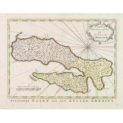
Carte Particuliére de L'Isle d'Amboine.
Uncommon edition of this detailed close-up of this Indonesian island Ambon, only infrequently encountered in this manner.With a pleasing title cartouche and 10. engraved ...
Date: Amsterdam, 1773
Selling price: ????
Please login to see price!
Sold in 2013
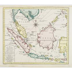
Carte des Isles de Java Sumatra et Borneo..
A very fine map centered on the islands of Java, Sumatra, Borneo and Malay Peninsular.From Atlas Portatif pour servir a l'intelligence de l'Histoire Philosophique et Poli...
Date: Amsterdam, 1773
Selling price: ????
Please login to see price!
Sold in 2012
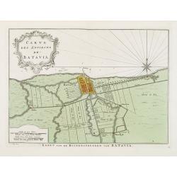
Carte Des Environs de Batavia.
Uncommon edition of this fine plan of Batavia, head quarters of the V.O.C. In lower right engraved 13.From Atlas Portatif pour servir a l'intelligence de l'Histoire Philo...
Date: Amsterdam, 1773
Selling price: ????
Please login to see price!
Sold in 2013
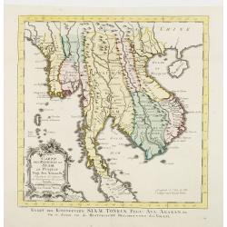
Carte Des Royaumes de Siam, de Runquin, Pegu. Ava..
Uncommon edition of this fine map incorporating information provided by French Jesuits, of Indochina, Malayan peninsular, Thailand, etc.From Atlas Portatif pour servir a ...
Date: Amsterdam, 1773
Selling price: ????
Please login to see price!
Sold
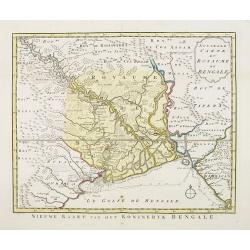
Nouvelle carte du Royaume de Bengale.
Uncommon issue of this detailed map of Bangladesh with the Ganges delta, including Calcutta. Giving great detail with trade routes, European trade settlements, etc.Prepar...
Date: Amsterdam, 1773
Selling price: ????
Please login to see price!
Sold
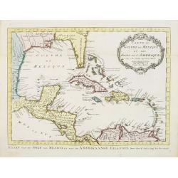
Carte du Golphe du Mexique et des Isles de L'Amerique.
Uncommon edition of this fine map of the Gulf of Mexico. With French text in title cartouche and an additional title in Dutch underneath the map.FromAtlas Portatif pour s...
Date: Amsterdam, 1773
Selling price: ????
Please login to see price!
Sold
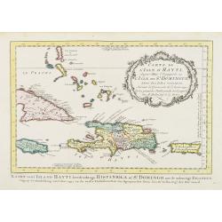
Carte de L'Isle d'Hayti, Aujour d'hui.. St.Domingue..
Uncommon edition of this fine map of Hispaniola and the neighboring islands Jamaica, Caymans, Porto Rico and eastern part of Cuba.Hispaniola divided into the five major c...
Date: Amsterdam, 1773
Selling price: ????
Please login to see price!
Sold
Carte réduite du Détroit de Magellan. . .
Uncommon edition of this fine map southern part of South America with Straits Magellan. In lower right engraved "27."From Atlas Portatif pour servir a l'intelli...
Date: Amsterdam, 1773
Selling price: ????
Please login to see price!
Sold in 2011
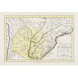
Carte du Paraguay et des Pays voisins..
Uncommon edition of this fine map of Paraguay. In lower right engraved "28."From Atlas Portatif pour servir a l'intelligence de l'Histoire Philosophique et Poli...
Date: Amsterdam, 1773
Selling price: ????
Please login to see price!
Sold in 2011
Suite du Bresil Depuis la Baie de Tous les Saints..
Uncommon edition of this accurate map of part of Brazil, from San Salvador till Rio de Janeiro and S.Paulo. In lower right engraved "29b."From Atlas Portatif po...
Date: Amsterdam, 1773
Selling price: ????
Please login to see price!
Sold
Suite du Bresil..
Uncommon edition of this accurate map of part of Brazil. In lower right engraved "29c."From Atlas Portatif pour servir a l'intelligence de l'Histoire Philosophi...
Date: Amsterdam, 1773
Selling price: ????
Please login to see price!
Sold
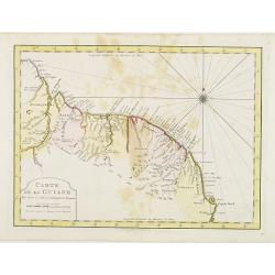
Carte de La Guiane..
Uncommon edition of this accurate map of part of Brazil. In lower right engraved "32."From Atlas Portatif pour servir a l'intelligence de l'Histoire Philosophiq...
Date: Amsterdam, 1773
Selling price: ????
Please login to see price!
Sold in 2022
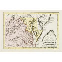
Carte de la Virginie et du Maryland, ou de la Baie de Chesapeack et pays voisins..
Uncommon edition of this accurate map showing Chesapeake Bay and part of New Jersey, Philadelphia and part of Virginia. In lower right engraved "39."From Atlas ...
Date: Amsterdam, 1773
Selling price: ????
Please login to see price!
Sold
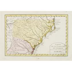
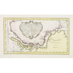
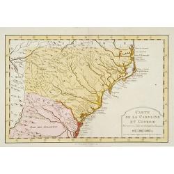
Carte de la Caroline et Georgie..
Uncommon edition of this early map of the Carolinas. In lower right engraved "40."From Atlas Portatif pour servir a l'intelligence de l'Histoire Philosophique e...
Date: Amsterdam, 1773
Selling price: ????
Please login to see price!
Sold
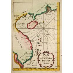
Carte des Costes de Cochin Chine, Tunquin et Partie de celles de la Chine.
Jaques Nicolas Bellin (1702-720) was the most important French hydrographer of the 18th century. Sea-atlas 'Hydrographique Français' , 1756-65, atlas to accompany Prévo...
Date: Amsterdam, 1773
Selling price: ????
Please login to see price!
Sold
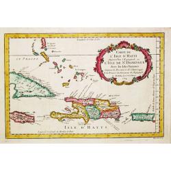
Carte de l' Isle d' Hayti, Aujourd'hui l' Espagnole, ou l' Isle de St. Dominique, Avec les Isles voisines.
Jaques Nicolas Bellin (1702-720) was the most important French hydrographer of the 18th century. Sea-atlas 'Hydrographique Français' , 1756-65, atlas to accompany Prévo...
Date: Amsterdam, 1773
Selling price: ????
Please login to see price!
Sold in 2008
Carte des isles Maldives.
A map of the Maldive Islands. Jacques Nicolas Bellin (1702-720) was the most important French hydrographer of the 18th century. He published a sea-atlas "Hydrographi...
Date: Amsterdam, 1773
Selling price: ????
Please login to see price!
Sold in 2017
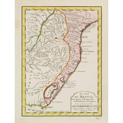
Suite du Bresil . . .
Uncommon edition of this accurate map of part of Brazil.From Atlas Portatif pour servir a l'intelligence de l'Histoire Philosophique et Politique des etablissements et du...
Date: Amsterdam, 1773
Selling price: ????
Please login to see price!
Sold in 2022
![Tête d'un guerrier de la Nouvelle Zélande. [Tome III Pl. 12.]](/uploads/cache/26094-250x250.jpg)
Tête d'un guerrier de la Nouvelle Zélande. [Tome III Pl. 12.]
Portrait of a Maori warrior. From the French edition of James Cook's first voyage entitled Relation des voyages entrepris par ordre de sa Majesté Britannique actuellemen...
Date: Paris, 1773
Selling price: ????
Please login to see price!
Sold in 2008
![Branche d\'un arbre-à-pain avec des fruits. [Tahiti.]](/uploads/cache/26096-250x250.jpg)
Branche d\'un arbre-à-pain avec des fruits. [Tahiti.]
Tree branch with fruits. From the French edition of James Cook\'s first voyage entitled Relation des voyages entrepris par ordre de sa Majesté Britannique actuellement r...
Date: Paris, 1773
Selling price: ????
Please login to see price!
Sold in 2008
![Vue de la Baye de Matavaï à Otahiti appellée Havre du Port - Royal par le Capitaine Wallis. [Tome II Pl. 9.]](/uploads/cache/26100-250x250.jpg)
Vue de la Baye de Matavaï à Otahiti appellée Havre du Port - Royal par le Capitaine Wallis. [Tome II Pl. 9.]
View of the Matavaï Bay in Tahiti, named The Haven of the Royal Port by Captain WallisFrom the French edition of James Cook's first voyage entitled Relation des voyages ...
Date: Paris, 1773
Selling price: ????
Please login to see price!
Sold in 2016
![Espève de Massue des Habitants de la Nouvelle Zélande appellées Patous-patous vus de côté du tranchant et du bout. Ils ont de 14 à 18 ouces de long. [Tome III Pl. 15.]](/uploads/cache/26101-250x250.jpg)
Espève de Massue des Habitants de la Nouvelle Zélande appellées Patous-patous vus de côté du tranchant et du bout. Ils ont de 14 à 18 ouces de long. [Tome III Pl. 15.]
Decorated bludgeons. From the French edition of James Cook's first voyage entitled Relation des voyages entrepris par ordre de sa Majesté Britannique actuellement régna...
Date: Paris, 1773
Selling price: ????
Please login to see price!
Sold in 2016
![Instruments des Insulaires de la Mer du Sud. [Tome II Pl. 14.]](/uploads/cache/26103-250x250.jpg)
Instruments des Insulaires de la Mer du Sud. [Tome II Pl. 14.]
Various tools. From the French edition of James Cook's first voyage entitled Relation des voyages entrepris par ordre de sa Majesté Britannique actuellement régnante po...
Date: Paris, 1773
Selling price: ????
Please login to see price!
Sold in 2021
![Vue des Indiens de la Terre de Feu dans leurs huttes. [Tome II Pl. 7.]](/uploads/cache/26105-250x250.jpg)
Vue des Indiens de la Terre de Feu dans leurs huttes. [Tome II Pl. 7.]
Family scene in a Patagonian hut. From the French edition of James Cook's first voyage entitled Relation des voyages entrepris par ordre de sa Majesté Britannique actuel...
Date: Paris, 1773
Selling price: ????
Please login to see price!
Sold in 2012
![Pirogue de guerre de la Nouvelle Zélande. [Tome III Pl. 14.]](/uploads/cache/26107-250x250.jpg)
Pirogue de guerre de la Nouvelle Zélande. [Tome III Pl. 14.]
A warrior dugout from New Zealand rowing along the coast. From the French edition of James Cook's first voyage entitled Relation des voyages entrepris par ordre de sa Maj...
Date: Paris, 1773
Selling price: ????
Please login to see price!
Sold in 2008
![Vue de l'intérieur d'une maison dans l'Isle d'Ulietéa. Representation d'une danse à la mode du pays. [Tome III Pl. 6.]](/uploads/cache/26114-250x250.jpg)
Vue de l'intérieur d'une maison dans l'Isle d'Ulietéa. Representation d'une danse à la mode du pays. [Tome III Pl. 6.]
Folkloric dance performance in a typical Ulietea house in French Polynesia. Engraved by Patas. From the French edition of James Cook's first voyage entitled Relation des ...
Date: Paris, 1773
Selling price: ????
Please login to see price!
Sold in 2008
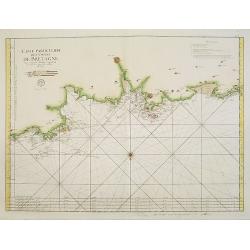
3. Carte Particuliere Des Costes De Bretagne Qui comprend Morlaix Saint Paul de Leon les Sept Isles et l'Isle de Bas..
Large-scale sea chart covering the French coast Brittany.With compass rose, rhumb lines and distance scale.Published by the Depot Générale de la marine with stamp and P...
Date: Paris, c.1773
Selling price: ????
Please login to see price!
Sold
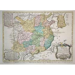
L'Empire de la Chine Pour Servir a l'Histoire des Etablissemens Europeens. Orbis terrarum
Attractive and detailed map of China and Korea, with Canton, Nanking and Taiwan. Taiwan is called Isle Tay-wan, ou de Formosa. The Sea of Japan is labeled Mer de Coree. T...
Date: Amsterdam, 1773
Selling price: ????
Please login to see price!
Sold in 2009
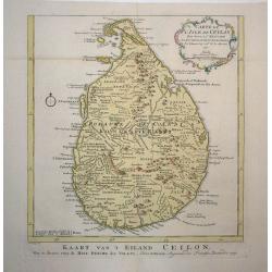
Carte de l'Isle de Ceylan
Detailed copper engraved map of the island with good detail inland of mountains, rivers, towns and villages. Rococo-style cartouche and a simple compass rose accent the m...
Date: Amsterdam, 1773
Selling price: ????
Please login to see price!
Sold in 2009
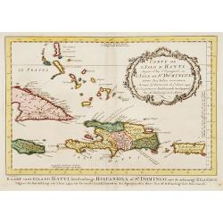
Carte de L'Issle d'Hayti, Aujour d'hui.. St.Domingue..
Uncommon edition of this fine map of Hispaniola and the neighboring islands Jamaica, Caymans, Porto Ricco and eastern part of Cuba. Hispaniola divided into the five major...
Date: Amsterdam, 1773
Selling price: ????
Please login to see price!
Sold in 2020
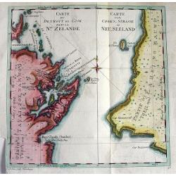
Carte du detroit de Cook dans La Nle. Zelande.
Very important map showing Cook's Strait, which separates the North and South islands of New Zealand. Present day Wellington, Marlborough Sounds, and Cloudy Bay are depic...
Date: Nuremberg, c1773
Selling price: ????
Please login to see price!
Sold in 2010
Plan de la ville de Geneve dedié aux très magnifiques très honorès seigneurs. . .
Scarce and beautiful town-plan of Geneva. Two inset plan, in the upper right corner "Plan de Geneva numbered key (1-56) to the important buildings and streets in tow...
Date: Paris, 1773
Selling price: ????
Please login to see price!
Sold in 2012
Carte de la Caroline et Georgie. . .
Uncommon edition of this early map of the Carolinas.From Atlas Portatif pour servir a l'intelligence de l'Histoire Philosophique et Politique des etablissements et du com...
Date: Amsterdam, 1773
Selling price: ????
Please login to see price!
Sold in 2016
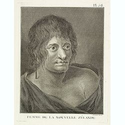
Femme de la Nouvelle Zélande. Pl. 58.
Portrait of a woman from New Zealand. From the French edition of James Cook's first voyage entitled Relation des voyages entrepris par ordre de sa Majesté Britannique ac...
Date: Paris, 1773
Selling price: ????
Please login to see price!
Sold in 2023
![[Insects] Plate XXI](/uploads/cache/15911-250x250.jpg)
[Insects] Plate XXI
Decorative plate from ''Naauwkeurige waarneemingen omtrent de veranderingen van veele insekten of gekorvene diertjes.'' Engraved by Ludwig Schmidt after Jablonsky. Printe...
Date: Amsterdam 1774
Selling price: ????
Please login to see price!
Sold in 2009
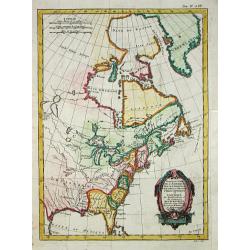
Partie du Nord de l' Amerique Septentrionale.
Rigobert Bonne (1727-1795), French cartographer. His maps are found in a.o. Atlas Moderne (1762), Raynal's Histoire Philos. du Commerce des Indes (1774) and Atlas Encyclo...
Date: Paris, 1774
Selling price: ????
Please login to see price!
Sold
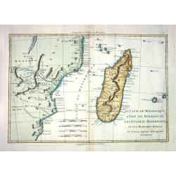
LE CANAL DE MOSAMBIQUE, L'ISLE DE MADAGASCAR, LES ETATS DU MONOMOTAPA ET LES ROYAUMES VOISINS
Detailed french map, by Bonne (Ingénieur-Hydrographique de la Marine de France) engraved by André. Many place-names and topographical detail on Madagascar, I. de Bourbo...
Date: Paris c. 1774
Selling price: ????
Please login to see price!
Sold
![[Insects]](/uploads/cache/09189-250x250.jpg)
[Insects]
Decorative plate from Naauwkeurige waarneemingen omtrent de veranderingen van veele insekten of gekorvene diertjes. Engraved by Ludwig Schmidt after Jablonsky. Printed by...
Date: Amsterdam, 1774
Selling price: ????
Please login to see price!
Sold in 2013
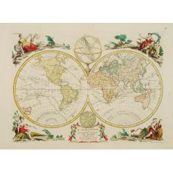
Il Mappamondo o sia Descrizione Generale del Globo
Double-hemisphere world, with allegorical figures of the Four Continents in the corners. Published just after the news of Cook's first circumnavigation was published, his...
Date: Venice 1774
Selling price: ????
Please login to see price!
Sold
![[Insects]](/uploads/cache/09187-250x250.jpg)
[Insects]
Decorative plate from Naauwkeurige waarneemingen omtrent de veranderingen van veele insekten of gekorvene diertjes. Engraved by Ludwig Schmidt after Jablonsky. Printed by...
Date: Amsterdam, 1774
Selling price: ????
Please login to see price!
Sold in 2009
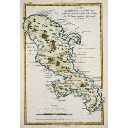
Carte de l\'Isle de la Martinique.
Rigobert Bonne (1727-1795), French cartographer. His maps are found in a.o. Atlas Moderne (1762), Raynal's Histoire Philos. du Commerce des Indes (1774) and Atlas Encyclo...
Date: Paris, 1774
Selling price: ????
Please login to see price!
Sold in 2010