Browse Listings
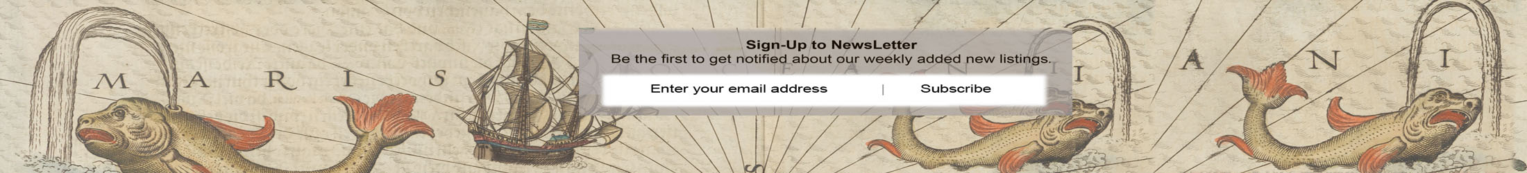
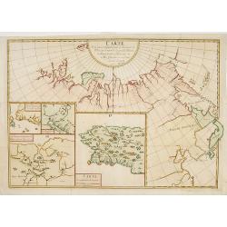
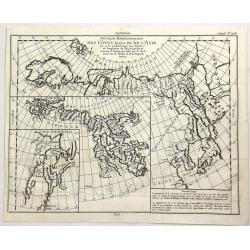
Des Côtes Nord et Est de L'Asie..
Three maps on one sheet, showing the north eastern coast line of China with Kamchatka. Prepared by Robert de Vaugondy. From his Encyclopedia.
Date: Paris, 1772
Selling price: ????
Please login to see price!
Sold in 2012
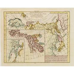
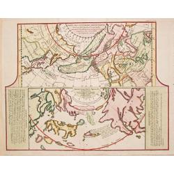
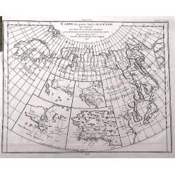
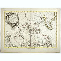
Carte Generale des Decouvertes de l' Amiral de Fonte representant la grande probabilite d'un Passage au Nord Ouest
The probably most extravagant of all the Northwest Passage maps after Thomas Jefferys, a passionate believer in the northern route to Asia and prepared this map to show t...
Date: Paris, 1772
Selling price: ????
Please login to see price!
Sold
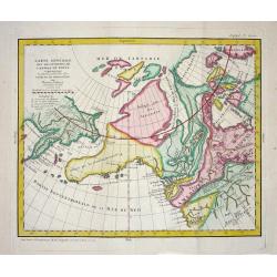
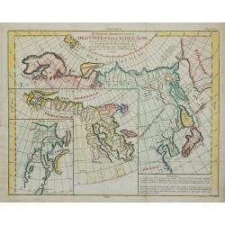
Carte des parties nord est ouest de L'Amerique..
Map of North America, as well as Canada & Alaska. California & the Pacific Northwest coast to Alaska is still speculative, whereas the east coast is depicted from...
Date: Paris 1772
Selling price: ????
Please login to see price!
Sold
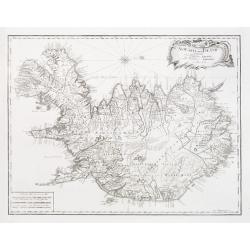
Nyt Carte over Island..
Very rare map of Iceland, important map as it is the first map to show Rekjavik. Engraved by Jonas Haas, signed and dated 1772. Prepared by n, Professor John Erichsen (17...
Date: Aar 1771 - 1772
Selling price: ????
Please login to see price!
Sold
Carte des nouvelles découvertes/ Extrait d\'une Carte Japonoise de l\'Universe.
Gilles Robert de Vaugondy (!686-1766) and son Didier (1723-86), Paris geographers and publishers. Gilles succeedded Pierre Moulart Sanson in 1730. "Atlas Portatif&qu...
Date: Paris, 1772
Selling price: ????
Please login to see price!
Sold in 2017
Nouvelle Représentation Des Côtes Nord Et Est De L'Asie ...
Three maps on one sheet, showing the north eastern coast line of China with Kamtschatka. From Diderot's Encyclopedie.
Date: Paris, 1772
Selling price: ????
Please login to see price!
Sold in 2011
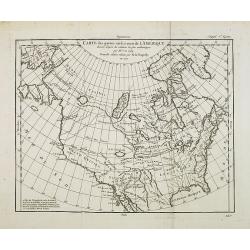
Carte des parties nord et ouest de l' Amerique. . .
Map of North America, as well as Canada & Alaska. California & the Pacific Northwest coast to Alaska is still speculative, whereas the east coast is depicted from...
Date: Paris, 1772
Selling price: ????
Please login to see price!
Sold in 2014
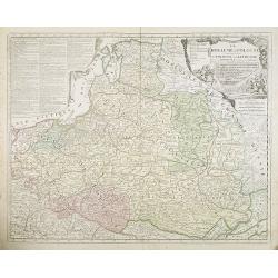
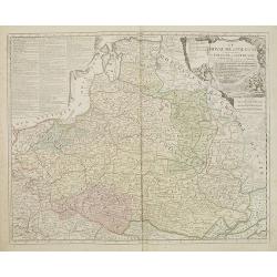
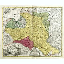
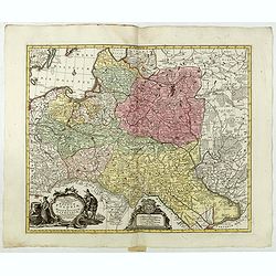
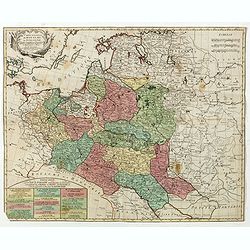
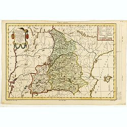
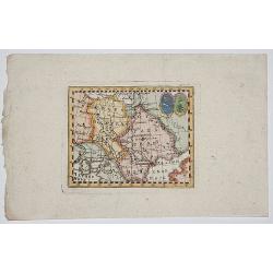
Le ROYAUME de POLOGNE Comprenant les Etats de Pologne et de Lithuanie, divisez en Province et Subdivisez en Palatinats. . .
Extends from about Vienna in the west to east of the Crimea and north to include the present day Baltic States. It includes all of the present day Ukraine.The map was fir...
Date: Paris, ca. 1742 - 1772
Selling price: ????
Please login to see price!
Sold in 2009
![(Title page) Carte de la Pologne dividé par Provinces et Palatinats et subdivisée par districts . . . 1772. N°21. [Title page]](/uploads/cache/27770-250x250.jpg)
(Title page) Carte de la Pologne dividé par Provinces et Palatinats et subdivisée par districts . . . 1772. N°21. [Title page]
Sheet 21 of the title sheet of the first detailed map of Poland, ca 1:692,000, in 24 sheets by G. Antonio Rizzi-Zannoni (1736-1814), an Italian who produced it for Duke J...
Date: Paris, 1772
Selling price: ????
Please login to see price!
Sold in 2009
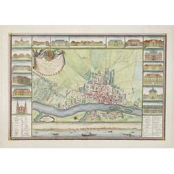
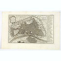
Plan de Varsovie levé par ordre de son Exc.e Mr. Le C.te Bielinski grand Maréchal de la couronne didié à son exc.e Mr. Le c.te Wielhorski. . .
Giovanni Antonio Rizzi-Zannoni (1736-1814) published in 1772 in Paris his famous map of Poland. This map was published in the form of an atlas, but could be easily assemb...
Date: Paris, 1772
Selling price: ????
Please login to see price!
Sold in 2009
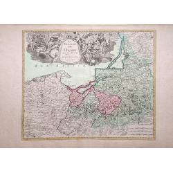
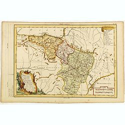
Le Royaume de Prusse Suivant les Nouvelles Observations.
George Louis le Rouge map of northern Poland, showing region along Baltic Sea.
Date: Paris, 1772
Selling price: ????
Please login to see price!
Sold in 2010
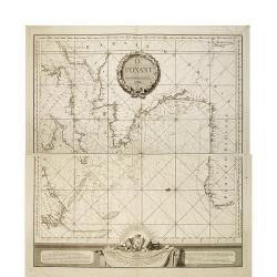
Le Ponant.
in two sheets. The chart depicts the Channel, including a detailed rendering of the south coast of England, the west coast of France and the north coast of Spain, includ...
Date: Le Havre, J.B. Patry, 1772
Selling price: ????
Please login to see price!
Sold in 2010
Carte de la partie Septentrionale et Orientale .. (5 maps on one sheet)
Five maps on one sheet, showing California, Alaska and Siberia and Japan.Map I showing Alaska, California as a peninsular, eastern tip of Japan with a curious Islade Plat...
Date: Paris, 1772
Selling price: ????
Please login to see price!
Sold in 2023
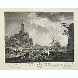
Le final exhaussé Dédié à Monseigneur le Duc de la Rochefoucauld Pair de France
Copper engraving after a painting of Joseph Claude Vernet (Le plus célébre des peintres de marine français du XVIII èm siécle.) Born in 1714 in Avignon and died in 1...
Date: Paris, J.Alaimet, ca.1772
Selling price: ????
Please login to see price!
Sold in 2011
Le ROYAUME de POLOGNE Comprenant les Etats de Pologne et de Lithuanie, divisez en Province et Subdivisez en Palatinats. . .
Extends from about Vienna in the west to east of the Crimea and north to include the present day Baltic States. It includes all of the present day Ukraine. The map was fi...
Date: Paris, ca. 1742 - 1772
Selling price: ????
Please login to see price!
Sold in 2017
XVIII Fle L'indicateur fidele du voyageur François.
Fine post road mapsroad map of the Provence from "L'Indicateur fidèle ou guide des voyageurs, qui enseigne toutes les routes royales et particulières de la France,...
Date: Paris, 1772
Selling price: ????
Please login to see price!
Sold
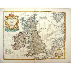
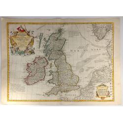
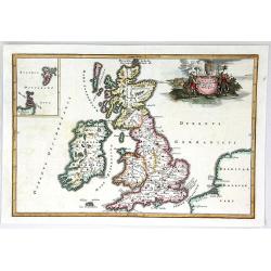
Les Isles Britanniques ou Sont le Royaumes d\'Angleterre .
Showing the British Isles and Ireland. It was published by Phillipe Buache in France in 1772. The map features two large Renaissance cartouches. Guillaume de l'Isle (167...
Date: Paris, 1772
Selling price: ????
Please login to see price!
Sold in 2013
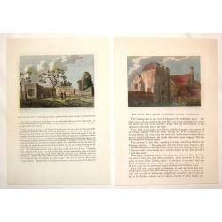
(2 Engravings) The Chapel of St. Pancrace, in St. Augustine's Monastery, Canterbury & The Great hall of the Archbishop's Palace, Canterbury
Two hand-colored, copper engravings of Canterbury architecture from Grose's "The Antiquities of England and Wales". Includes text concerning the location on the...
Date: London, 1772
Selling price: ????
Please login to see price!
Sold in 2016
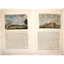
(2 Engravings) Leeds Castle, Kent & The Priory of Davyngton, Neat Faversham, Kent.
Two hand-colored, copper engravings featuring antique architectural buildings in Kent. These Prints are from Grose's "The Antiquities of England & Wales" an...
Date: London, 1772
Selling price: ????
Please login to see price!
Sold in 2016
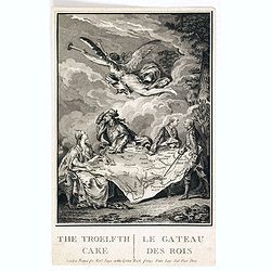
The Troelfth Cake. - Le Gateau Des Rois ...
A dramatic cartographic curiosity illustrating the division of northern Europe effected by the first partition of Poland, in which the map, shown on a large canvas is tor...
Date: London, 1772
Selling price: ????
Please login to see price!
Sold in 2014
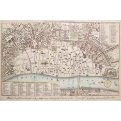
A PLAN OF THE CITY AND LIBERTIES OF LONDON; SHEWING THE EXTENT OF THE DREADFUL CONFLAGRATION IN THE YEAR 1666.
Based on Wenceslaus Hollar's 1666 map of the Great Fire of London. A highly detailed map of the City of London and its environs, designed to show the vast extent of the G...
Date: London, 1772
Selling price: ????
Please login to see price!
Sold in 2015
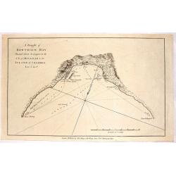
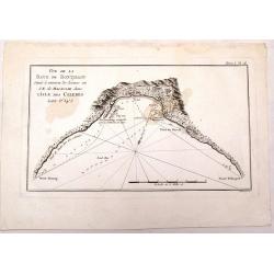
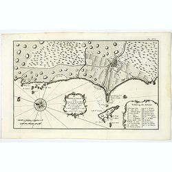
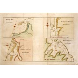
A Draught of Bonthain Bay Situated About 30 Leagues to the S.E. of Macassar in the Island of Celebes.
Interesting copper engraved nautical chart featuring the Bantaeng Region of Indonesia.< Relief shown pictorially and by hachures with depths by soundings.
Date: London, 1772
Selling price: ????
Please login to see price!
Sold in 2016
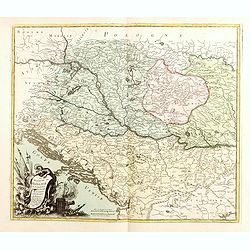
Le Royaume de Hongrie la Transilvanie L'Esclavonie la Croatie et la Bosnie.
Fine map of Hungary, Slovakia, Romania, etc. with a splendid cartouche of an elephant, a crocodile and a canon and canon balls in the forefront and an array of flags amid...
Date: Paris, 1772
Selling price: ????
Please login to see price!
Sold in 2019
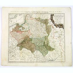
Mappa geographiaca ex novisimis observationibus repraesentans regnum Poloniae et Magnum Lithuaniae . . .
Uncommon map of Poland. Tobias Conrad Lotter married Matthias Seutter's daughter in 1740 and succeeded him in 1756. Lotter used the copperplate of Seutter, he only change...
Date: Augsburg, 1772
Selling price: ????
Please login to see price!
Sold in 2015
A Draught of Bonthain Bay.
A fine map of Bonthian Bay on the Island of Sulawesi, in Indonesia. The bay is about 30 leagues to the southeast of Macassar.
Date: Paris, 1772
Selling price: ????
Please login to see price!
Sold in 2015
Mappa Geographica ex novissimis observationibus repraesentans Regnum Poloniae Et Magnum Ducatum Lithuaniae.
Uncommon map of Poland, Latvia, Lithuania, Estonia and Belarus. Below coats of arms of Stanislaw August Poniatowski (1732-1798) the last King and Grand Duke of the Polish...
Date: Augsburg, ca. 1772
Selling price: ????
Please login to see price!
Sold in 2015
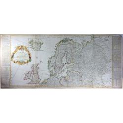
A New and Accurate Map of Europe. Divided into its Empires, Kingdoms, States and Republics. . .
An exceptional example of the top two sheets of this wall map size 4-sheet map of Europe. Includes extensive text and tables on either side of the map. This map of the ...
Date: London, 1772
Selling price: ????
Please login to see price!
Sold in 2016
Les Isles Britanniques ou sont le Rme. d'Angleterre Tire de Sped Celuy d'Ecosse...
Originally issued in 1702 by Delisle, this influential map of the British Isles map has his characteristic crisp style and topographical detail. On the right hand side th...
Date: Paris, 1772
Selling price: ????
Please login to see price!
Sold in 2016
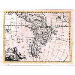
South America
"South America" by Thomas Jefferys, published in “A New Geographical and Historical Grammar” in London in 1772.Thomas Jefferys (c.1719–1771), "Geogra...
Date: London, 1772
Selling price: ????
Please login to see price!
Sold in 2017
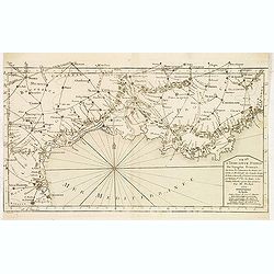
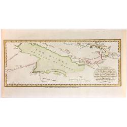
Carte des parties Nord et Est de L'Asie...
Interesting map of the northern coastline of Russia, the eastern coast of Asia with Korea, Japan, and China, and a bit of the coast of America called Anian. With four sm...
Date: Paris, 1772
Selling price: ????
Please login to see price!
Sold in 2016
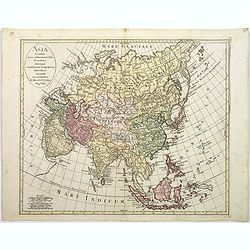
Asia secundum novas celeberrimi de l'Isle Projectiones aliorumque. . .
A pleasant map of the continent of Asia, with each country displayed in a different color. Plain oval title cartouche. A set of 5 different mileage scales lower left corn...
Date: Augsburg, 1772
Selling price: ????
Please login to see price!
Sold in 2017
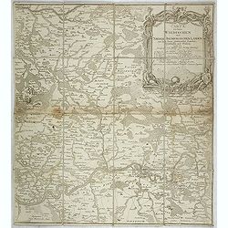
Carte von denen Wiedischen und Nieder Isenburgischen Landen mit den daran gräntzenden Landen, Ortschaften und Flüssen, nebst dem Prospect vom Schloß und Flecken Isenburg. . .
The right hand sheet of a 2-sheet map of Wiedische and Isenburg land. Shows the course of the River Lahn from the mouth into the Rhine near Nassau, Montabaur, Limburg. To...
Date: Frankfurt am Main, 1772
Selling price: ????
Please login to see price!
Sold in 2021
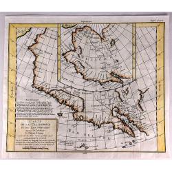
Carte de la Californie et des Pays Nord-Ouest Separes de l'Asie par le Detroit d'Aman.
An interesting study in the comparative cartography of the West Coast of North America in California. The work consists of extracts from two maps, both reportedly done b...
Date: Paris, 1772
Selling price: ????
Please login to see price!
Sold in 2017
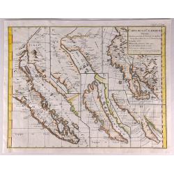
Carte de la Californie Suivant.
A historically important depiction of the 5 most influential cartographic depictions of California, showing the evolution of how California was mapped between 1604 and 17...
Date: Paris, 1772
Selling price: ????
Please login to see price!
Sold in 2017
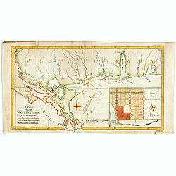
A Map of Part of West Florida from Pensacola to the Mouth of the Iberville River, with a view to shew the proper spot for a Settlement on the Mississipi.
Uncommon map of the Mississippi delta and coastal regions of Mississippi, Alabama and the panhandle of Florida., from the February 1772 edition of Gentleman's Magazine, w...
Date: London 1772
Selling price: ????
Please login to see price!
Sold in 2017
Nouvelle Representation des Cotes Nord et Est de L'Asie. . .
An interesting map with three overlaid maps on one sheet. Shows northern coast of Europe and Asia possibly focusing on the idea of a North East Passage. Japan (Nippon) an...
Date: Paris, 1772
Selling price: ????
Please login to see price!
Sold in 2023
Carte nouvelle du Royaume de Pologne . . .
Uncommon map of the Poland kingdom by Matthieu Albert Lotter (1741-1810), who worked with his father Tobias Conrad and succeeded to his business. Lotter Jr. Gives credit ...
Date: Augsburg, 1772
Selling price: ????
Please login to see price!
Sold in 2019
De Haven van Callao in de Stille of Zuid-Zee. . .
An attractive plan of the Peruvian port of Callao, and her surrounds, including Lima, some 15 km's to the east. From a Dutch edition of an important report of a French/Du...
Date: Amsterdam, ca 1772
Selling price: ????
Please login to see price!
Sold in 2019
Platte-Grond van Lima Hoofdstadt van Peru. . .
An attractive plan of the Peruvian capital of Lima. From a Dutch edition of an important report of a French/Dutch expedition through South America in 1772. The map depict...
Date: Amsterdam, ca 1772
Selling price: ????
Please login to see price!
Sold in 2023
![[Untitled] De Stad Louisburg of van Kaap Breton. . .](/uploads/cache/43969-250x250.jpg)
[Untitled] De Stad Louisburg of van Kaap Breton. . .
A plan of the French Fortress of Louisbourg, and the immediate surrounds. The Fortress today is a National Historic Site of Canada, and the location of a one-quarter part...
Date: Amsterdam, ca 1772
Selling price: ????
Please login to see price!
Sold in 2019
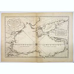
Carte Reduite de la Mer Noire. . .
Bellin's classic chart of the Black Sea that was ordered by M. de Boynes, Secretary of State of the Department of the Navy (Depot de la Marine) for use by official French...
Date: Paris, ca 1772
Selling price: ????
Please login to see price!
Sold in 2019
Atlas portatif pour servir à l'intelligence de l'histoire philosophique et politique des établissements et du commerce des Européens dans les Deux Indes.
Scarce atlas with maps of al parts of the world after R.Bonne. The maps have titles in French, but the scales and subtitle underneath the map are in Dutch. Each map has b...
Date: Amsterdam, E. van Harrevelt, D.J. Changuion, 1773
Selling price: ????
Please login to see price!
Sold in 2012
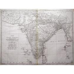
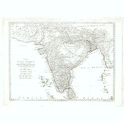
The East Indies including more particularly the British Dominions on the Continent of India...
Very detailed map of India with Ceylon. Extends to include the Maledives, Andaman Islands, Tibet, Pegu, and a tiny part of Sumatra. Engraved by Thomas Kitchin.
Date: London, 1773
Selling price: ????
Please login to see price!
Sold in 2013
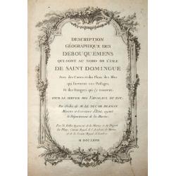
Description Géographique des Debouquemens qui sont au nord de l'isle de Saint Domingue.
Scarce Atlas of the Bahamas, including maps of Bermuda, the Strait of Florida, Turks & Caicos, St. Augustine, etc. With the engraved title dating 1768. With 34 (part...
Date: Paris, 1773
Selling price: ????
Please login to see price!
Sold in 2014
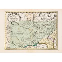
Carte de la Louisiane et Pays Voisins..
Uncommon edition of this accurate map centered on Louisiana and extending eastwards as far as the Atlantic seacoast. In lower right engraved "33."From Atlas Por...
Date: Amsterdam, 1773
Selling price: ????
Please login to see price!
Sold in 2019
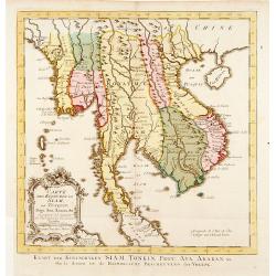
Carte Des Royaumes de Siam, de Runquin, Pegu. Ava. . .
Uncommon edition of this fine map incorporating information provided by French Jesuits, of Indochina, Malayan peninsular, Thailand, etc.From Atlas Portatif pour servir a ...
Date: Amsterdam, 1773
Selling price: ????
Please login to see price!
Sold in 2021
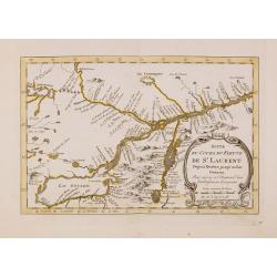
Carte du cours du Fleuve de St.Laurent Depuis son Embouchure..
Scarce edition of this accurate map showing the lower St.Laurence, including Quebec. Second state. In lower right engraved "34b."From Atlas Portatif pour servir...
Date: Amsterdam, 1773
Selling price: ????
Please login to see price!
Sold in 2014
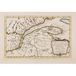
Suite du cours du Fleuve de St.Laurent Depuis Quebec jusqu'au Lac Ontario..
Scarce edition of this accurate map showing the upper St.Laurence. In lower right engraved "34c."From Atlas Portatif pour servir a l'intelligence de l'Histoire ...
Date: Amsterdam, 1773
Selling price: ????
Please login to see price!
Sold
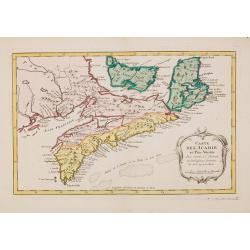
Carte de L'Acadie et Pais Voisins. . .
Scarce edition of this fine map of Maritime Canada. This is an intermediate state between Kershaw 785/786: the map has an engraved nr. 37.Louisburg and Baie Chedabouctou ...
Date: Amsterdam, 1773
Selling price: ????
Please login to see price!
Sold in 2014

The Right Reverend Father in God, Edward Willes, D.D.
Fine large mezzotint portrait print of Reverend Edward Willes. Engraved by John Faber after Thomas Hudson. Published in London 1773. Interestingly, it has a price of two ...
Date: London, 1773
Selling price: ????
Please login to see price!
Sold in 2018
4 Nautical Charts in One - Matavia Bay in Otaheite etc.
This striking map is made up of four nautical charts including: - Matavia Bay in Otaheite, - Ohamaneno Harbour in Ulietea, - Owharre Harbour in Houheine & - Oopoah Ha...
Date: London, 1773
Selling price: ????
Please login to see price!
Sold in 2020
Chorographie de la Vieille et Nouvelle Castille. . .
The text has been engraved by Herault and the map by Maurille-Antoine Moithey. Embellished with a decorative title cartouche.
Date: Paris, ca. 1773
Selling price: ????
Please login to see price!
Sold in 2015
Chorographie de Royaumes d'Aragon, de Navarre et de la Province de Biscaye. . .
The text has been engraved by Herault and the map by Maurille-Antoine Moithey. Embellished with a decorative title cartouche.
Date: Paris, ca. 1773
Selling price: ????
Please login to see price!
Sold in 2015
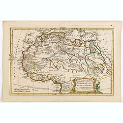
Barbarie, Egypte, Nigritie, Guinée, Nubie, Abassinie. . .
The map has been engraved by E. Dussy and the map is after Robert de Vaugondy. Embellished with a decorative title cartouche.
Date: Paris, ca. 1773
Selling price: ????
Please login to see price!
Sold in 2015
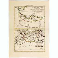
Etats du Roi de Maroc. .
The map has been engraved by André and the map is after Rigobert Bonne (1727–1795) who was one of the most important cartographers of the late 18th century.
Date: Paris, ca. 1773
Selling price: ????
Please login to see price!
Sold in 2015
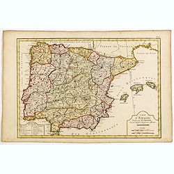
Carte d'Espagne. . .
Map of Spain and Portugal engraved by J.E.J. Vallet.
Date: Paris, ca. 1773
Selling price: ????
Please login to see price!
Sold in 2015

Carte Particuliere d'une Partie des Riviers de Berbice et de Caroje, Pour L'Intelligence de la Relation Touchant l Revolt des Negres en 1763
Plan of Berbice, Surinam at the time of the slave revolt of 1763. The slaves revolted and forced the plantation owners out of the country.
Date: Amsterdam, 1773
Selling price: ????
Please login to see price!
Sold in 2018
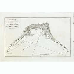
A Draught of Bonthain Bay situated about 30 Leagues to the S E of Macassar in the Island of Celebes. . .
Bonthain Bay at the island of Sulawesi [i.e. Celebes]. The bay is about 30 leagues to the southeast of Macassar. Large amount of detail in the bay including the location ...
Date: London, W. Strahan and T. Cadell, 1773
Selling price: ????
Please login to see price!
Sold in 2022

Malva vulgaris./ Gemeine Pappel. (Malvae)
Copper engraved print; overall size 36 x 22,5 cm from the German edition of Blackwell's 'Herbarium Blackwellianum...' or 'A Curious Herbal,' originally published in Londo...
Date: Nurnberg, 1757-1773
Selling price: ????
Please login to see price!
Sold in 2015

Calendula./ Ringelblume.
Copper engraved print; overall size 36 x 22,5 cm from the German edition of Blackwell's 'Herbarium Blackwellianum...' or 'A Curious Herbal', originally published in Londo...
Date: Nurnberg, 1757-1773
Selling price: ????
Please login to see price!
Sold in 2015

Caprifolium./ Jericher Rosen (Honeysuckle)
Copper engraved print; overall size 36 x 22,5 cm from the German edition of Blackwell's 'Herbarium Blackwellianum...' or 'A Curious Herbal', originally published in Londo...
Date: Nurnberg, 1757-1773
Selling price: ????
Please login to see price!
Sold in 2015

Lilium Album. Weise Lilie.
Copper engraved print; overall size 36 x 22,5 cm from the German edition of Blackwell's 'Herbarium Blackwellianum...' or 'A Curious Herbal', originally published in Londo...
Date: Nürnberg, 1757–1773
Selling price: ????
Please login to see price!
Sold in 2015
![Fragaria. Erdbeerkraut. [Strawberry]](/uploads/cache/95774-250x250.jpg)
Fragaria. Erdbeerkraut. [Strawberry]
Copper engraved print; overall size 36 x 22,5 cm from the German edition of Blackwell's 'Herbarium Blackwellianum...' or 'A Curious Herbal', originally published in Londo...
Date: Nurnberg, 1757-1773
Selling price: ????
Please login to see price!
Sold in 2015
![Amoris Pomum. Liebs-Aepfel. [Tomato]](/uploads/cache/95775-250x250.jpg)
Amoris Pomum. Liebs-Aepfel. [Tomato]
Copper engraved print; overall size 36 x 22,5 cm from the German edition of Blackwell's 'Herbarium Blackwellianum...' or 'A Curious Herbal', originally published in Londo...
Date: Nurnberg, 1757-1773
Selling price: ????
Please login to see price!
Sold in 2015
![Morus nigra vulgaris. Maulbeer Baum. [Mulberry tree]](/uploads/cache/95776-250x250.jpg)
Morus nigra vulgaris. Maulbeer Baum. [Mulberry tree]
Copper engraved print; overall size 36 x 22,5 cm from the German edition of Blackwell's 'Herbarium Blackwellianum...' or 'A Curious Herbal', originally published in Londo...
Date: Nurnberg, 1757-1773
Selling price: ????
Please login to see price!
Sold in 2015

Acanthus Branca Ursina. Welsche Baeren-Klau.
Copper engraved print; overall size 36 x 22,5 cm from the German edition of Blackwell's 'Herbarium Blackwellianum...' or 'A Curious Herbal', originally published in Londo...
Date: Nurnberg, 1757-1773
Selling price: ????
Please login to see price!
Sold in 2015
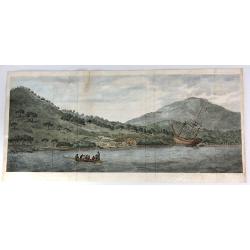
A View of the Endeavour River, on the coast of New Holland ...
The first known landscape drawing of the east coast of Australia. A view of the Endeavour River, on the coast of New Holland, where the ship was laid on shore, in order t...
Date: London, 1773
Selling price: ????
Please login to see price!
Sold in 2016
A Chart of Captain Carteret's Discoveries at New Britain, with Part of Captain Cook's Passage Thro Endeavour Streights, & of Captain Dampier's Tract & Discoveries in 1699, & 1700, at New Guinea & New Britain
This fine chart of Papua New Guinea shows the new discoveries of Captains Cook, Carteret, and Dampier along New Guinea, New Britain, and New Ireland. The chart details th...
Date: London, 1773
Selling price: ????
Please login to see price!
Sold in 2018
Insularum Britannicarum Facies Antiqua
A fine copperplate map of ancient Britain by Christophorus Cellarius in 1773. The Orkney and Shetland islands are shown in an insert at the top left corner. The decorativ...
Date: Leipzig, 1773
Selling price: ????
Please login to see price!
Sold in 2019
The East Indies . . .
Highly detailed map of India and Sri Lanka, drawn by Thomas Kitchin and published in the London Magazine. Cities, towns and geographical features are all shown.
Date: London, 1773
Selling price: ????
Please login to see price!
Sold in 2018
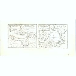
Entrance of Endeavour River / Botany Bay in new South Wales.
A scarce pair of very early nautical charts of Botany Bay and the mouth of the Endeavour River in the newly discovered colony of New South Wales. The charts are based on ...
Date: London, 1773
Selling price: ????
Please login to see price!
Sold in 2017
Partie de l'Amerique Septentrionale.. Canada, la Louisiane...
Interesting map of the eastern part of Canada with Hudson Bay, Baffin Bay and Greenland.
Date: Paris/ Bordeaux, 1773
Selling price: ????
Please login to see price!
Sold in 2018
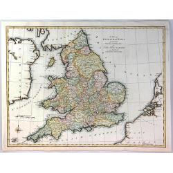
A Map of England and Wales from the Latest Authorities and Observations
A fine map of England and Wales by John Blair L.L.D. & F.R.S. issued as a Supplement to his Tables of Chronology. The Counties of England, and Wales are all separatel...
Date: London, 1773
Selling price: ????
Please login to see price!
Sold in 2018
(Baltic States and Russia)
A copperplate Russian map of the Baltic States and surrounding country of St. Petesburg.Taken from "General Map of the Russian Empire and Maps of Provinces" whi...
Date: Skt. Peterburg, 1761-1773
Selling price: ????
Please login to see price!
Sold in 2017
Sourthen Russia, Ukraine, Belarus, Novo Russia/ Novorossiya.
Copperplate map of southern Russia, Ukraine, Belarus, Novo Russia (aka Novorossiya). Taken from "General Map of the Russian Empire and Maps of Provinces" which ...
Date: St. Petersburg, 1761-1773
Selling price: ????
Please login to see price!
Sold in 2017
RUSSIA, UKRAINE.
Copperplate map of southern eastern european Russia. Taken from "General Map of the Russian Empire and Maps of Provinces" which contained a general map of the E...
Date: St. Petersburg, 1761-1773
Selling price: ????
Please login to see price!
Sold in 2017
!['Finljandskoi' [St.Petersburg Region]](/uploads/cache/98745-250x250.jpg)
'Finljandskoi' [St.Petersburg Region]
A colored copperplate map of St. Petersburg and surrounding country, in Cyrillic . Taken from "General Map of the Russian Empire and Maps of Provinces" which co...
Date: St. Petersburg, 1761-1773
Selling price: ????
Please login to see price!
Sold in 2019
Mappa Geographica Regni Poloniae ex novissimis quot quot sunt mappis. . .
A map of Poland, Lithuania and Belarus, first published in 1750 by Homann Heirs, and now re-issued in 1773. Coastline includes all between Riga and Gdansk. Map is based o...
Date: Nuremberg, 1773
Selling price: ????
Please login to see price!
Sold in 2018
![[Untitled] but Chart of the Track of the Dolphin, Tamar, Swallow & Endeavour through the South Seas & the track of M.Bougainville. . .](/uploads/cache/42647-250x250.jpg)
[Untitled] but Chart of the Track of the Dolphin, Tamar, Swallow & Endeavour through the South Seas & the track of M.Bougainville. . .
The map is one of a three part set, comprising of three sheets covering the world, and detailing Cook's first voyage. This is the Americas map is (part 1) and was issued ...
Date: London, 1773
Selling price: ????
Please login to see price!
Sold in 2020
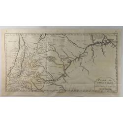
Cours de L'Orenoque Depuis ses Sources Jusqu'a la Mer.
An uncommon copper engraved map of the mouth of the Orinoco River, in South America. The map covers the countries of Colombia and Venezuela. A simple block-style title c...
Date: Paris, 1773
Selling price: ????
Please login to see price!
Sold in 2020