Browse Listings in Polar maps
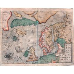
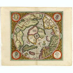
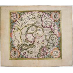
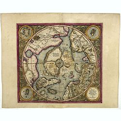
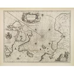
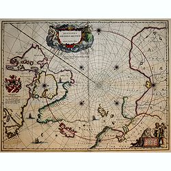
Septentrionalium Regionum Descrip.
Influential map of the Arctic. It includes Scandinavia, Iceland, Greenland and part of the North American continent, together with the legendary islands of the north: Dro...
Date: Antwerp, ca. 1590
Selling price: ????
Please login to see price!
Sold in 2015
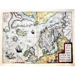
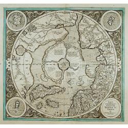
Septentrionalium Regionum Descrip.
An influential map of the Arctic. It includes Scandinavia, Iceland, Greenland and part of the North American continent, together with the legendary islands of the north: ...
Date: Antwerp, 1590
Selling price: ????
Please login to see price!
Sold in 2018
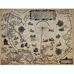
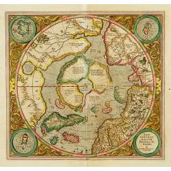
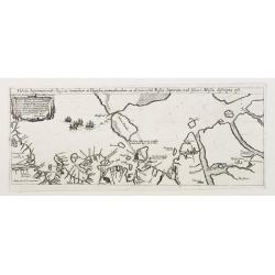
Deliniatio cartae trium navigationum per Batavos..
A major landmark in Arctic cartography incorporating recent voyages including Barents' third voyage to this region, made in 1596-7. A derivative of Willem Barentsz's map ...
Date: Frankfurt, 1599
Selling price: ????
Please login to see price!
Sold in 2017
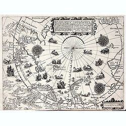
Deliniatio cartae trium navigationum per Batavos. . .
A major landmark in Arctic cartography incorporating recent voyages including Barents' third voyage to this region, made in 1596-7. A derivative of Willem Barentsz's map ...
Date: Frankfurt, 1599
Selling price: ????
Please login to see price!
Sold in 2012
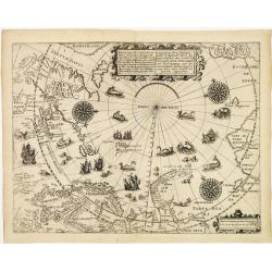
Deliniatio cartae trium navigationum per Batavos..
A major landmark in Arctic cartography incorporating recent voyages including Barents' third voyage to this region, made in 1596-7. A derivative of Willem Barentsz's map ...
Date: Frankfurt 1599
Selling price: ????
Please login to see price!
Sold
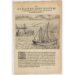
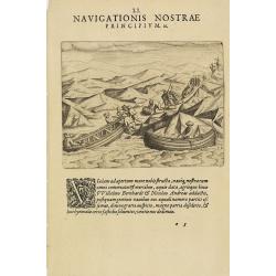
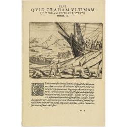
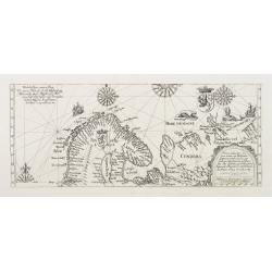
The third Dutch artic voyage by W.Barentsz.
These famous and desirable scene is engraved by de Bry, depicting the two open ships during the return voyage during the third Dutch Arctic voyage to find the north-east ...
Date: Frankfurt, 1601
Selling price: ????
Please login to see price!
Sold in 2022
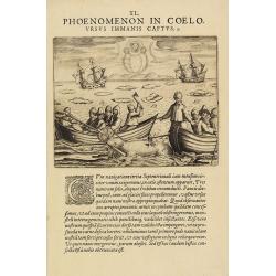
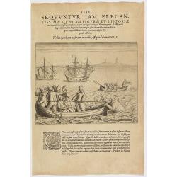
The third Dutch artic voyage by W.Barentsz.
Scene during the third Dutch arctic voyage in order to find the north-east passage to India.Barentsz made three voyages (1594, 1595, 1596-1597) in search of the Northeast...
Date: Frankfurt, 1601
Selling price: ????
Please login to see price!
Sold in 2016
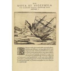
The third Dutch artic voyage by W.Barentsz.
Desirable scene during the third Dutch arctic voyage in order to find the north-east passage to India.Barentsz made three voyages (1594, 1595, 1596-1597) in search of the...
Date: Frankfurt, 1601
Selling price: ????
Please login to see price!
Sold
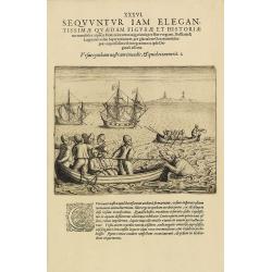
The third Dutch artic voyage by W.Barentsz.
Desirable scene during the third Dutch arctic voyage in order to find the north-east passage to India.Barentsz made three voyages (1594, 1595, 1596-1597) in search of the...
Date: Frankfurt, 1601
Selling price: ????
Please login to see price!
Sold
The third Dutch artic voyage by W.Barentsz.
Desirable scene during the third Dutch arctic voyage in order to find the north-east passage to India.Barentsz made three voyages (1594, 1595, 1596-1597) in search of the...
Date: Frankfurt, 1601
Selling price: ????
Please login to see price!
Sold
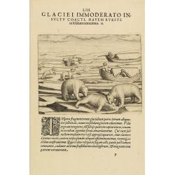
The third Dutch artic voyage by W.Barentsz.
Depicting a scene during the third Dutch arctic voyage in order to find the north-east passage to India.Barentsz made three voyages (1594, 1595, 1596-1597) in search of t...
Date: Frankfurt, 1601
Selling price: ????
Please login to see price!
Sold
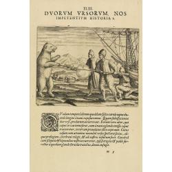
The third Dutch artic voyage by W.Barentsz.
This desirable scene during the third Dutch arctic voyage in order to find the north-east passage to India.Barentsz made three voyages (1594, 1595, 1596-1597) in search o...
Date: Frankfurt, 1601
Selling price: ????
Please login to see price!
Sold in 2017
The third Dutch artic voyage by W.Barentsz.
This desirable scene during the third Dutch arctic voyage in order to find the north-east passage to India.Barentsz made three voyages (1594, 1595, 1596-1597) in search o...
Date: Frankfurt, 1601
Selling price: ????
Please login to see price!
Sold in 2017
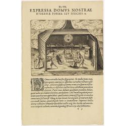
The third Dutch artic voyage by W.Barentsz.
This famous and desirable scene of the interior of "Het Behouden Huys", during the third Dutch arctic voyage in order to find the north-east passage to India.Ba...
Date: Frankfurt, 1601
Selling price: ????
Please login to see price!
Sold
The third Dutch artic voyage by W.Barentsz.
These famous and desirable scene is engraved by de Bry depicting a scene during the third Dutch arctic voyage in order to find the north-east passage to India.Despite the...
Date: Frankfurt, 1601
Selling price: ????
Please login to see price!
Sold in 2018
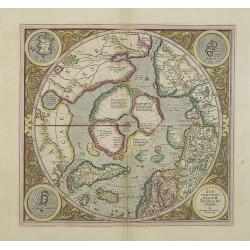
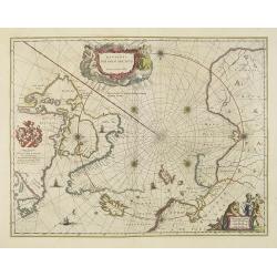
SEPTENTRIONALIUM Terrarum descriptio. Per Gerardum Mercatore.
State 2. This is the first map devoted to the Arctic, a hemispherical one on a North Polar projection with an attractive floral design surrounding it. In the corners are ...
Date: Amsterdam, 1609
Selling price: ????
Please login to see price!
Sold in 2013
Septentrionalium Terrarum descriptio. Per Gerardum Mercatorem Cum Privilegio.
State 2. This is the first map devoted to the Arctic, a hemispherical one on a North Polar projection with an attractive floral design surrounding it. In the corners are ...
Date: Amsterdam, 1609
Selling price: ????
Please login to see price!
Sold in 2015
SEPTENTRIONALIUM Terrarum descriptio. Per Gerardum Mercatore
State 2. This is the first map devoted to the Arctic, a hemispherical one on a North Polar projection with an attractive floral design surrounding it. In the corners are ...
Date: Amsterdam 1609
Selling price: ????
Please login to see price!
Sold
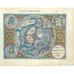
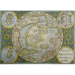
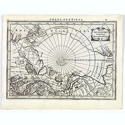
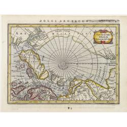
Polus Arcticus cum vicinis regionibus.
Early map of the North Polar regions. Shows the mythical land masses near the pole, the clearly navigable NW and NE passages, a massive California and marvelous detail in...
Date: Amsterdam, 1610
Selling price: ????
Please login to see price!
Sold in 2014
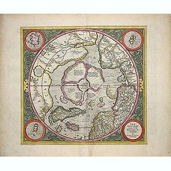
Septentrionalium Terrarum descriptio
This influential map was the first separately printed map devoted to the Arctic. The hemisphere is surrounded by a floral design with four roundels in each corner. These ...
Date: Amsterdam, 1611
Selling price: ????
Please login to see price!
Sold in 2011
Tabula Septentrionalis Russiae, Samoithiae et Tingosiae..
A very rare map was published by Hessel Geritsz. describing the northern passage according to Isaac Massa. Hessel Gerritsz. published his Beschryvinghe vander Samoyeden L...
Date: Amsterdam 1613
Selling price: ????
Please login to see price!
Sold
Vera delineatio totius tractus ex Hollandia.. Lintschottani.
A very rare map was published by Hessel Geritsz. describing Jan Huijgen van Linschoten's voyage of 1594 -95 in order to find a north passage to the East.Hessel Gerritsz. ...
Date: Amsterdam 1613
Selling price: ????
Please login to see price!
Sold
Polus Arcticus cum vicinis regionibus
Excellent early map of the North Polar regions, based upon early maps by Mercator and Hondius.Shows the mythical land masses near the pole, the clearly navigable NW and N...
Date: Amsterdam, 1613
Selling price: ????
Please login to see price!
Sold in 2023
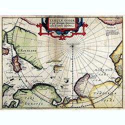
Tabula Geogr. In qua admirandae navigatonis..
A finely engraved map by Jodocus Hondius with coastline details of northern Europe, Greenland, Frisland, Strait Anian with America pars. With the track of a Willem Barent...
Date: Amsterdam, 1614
Selling price: ????
Please login to see price!
Sold in 2019
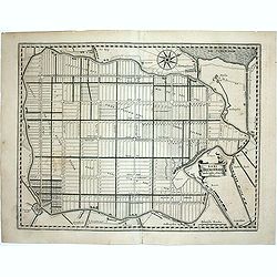
Agri Biemstrani Descriptio a L.I.S.
Detailed map of the polder Beemster in Noord Holland. Including the towns of Purmerend, De Ryp, Oudendijk, etc. The oldest area reclaimed from the sea in the Netherlands....
Date: Amsterdam, 1617
Selling price: ????
Please login to see price!
Sold in 2011
SEPTENTRIONALIUM Terrarum descriptio. Per Gerardum Mercatore
State 2. This is the first map devoted to the Arctic, a hemispherical one on a North Polar projection with an attractive floral design surrounding it. In the corners are ...
Date: Amsterdam, 1623
Selling price: ????
Please login to see price!
Sold in 2019
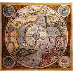
SEPTENTRIONALIUM Terrarum descriptio. Per Gerardum Mercatore
State 2. This is the first map devoted to the Arctic, a hemispherical one on a North Polar projection with an attractive floral design surrounding it. In the corners are ...
Date: Amsterdam, 1623
Selling price: ????
Please login to see price!
Sold in 2016
Septentrionalium Terrarum decsript.
A good example of Mercator-Jansson's small map of the North Polar regions.The map is extended to 60 degrees, to show the recent explorations in search of the North West a...
Date: Amsterdam, ca. 1628
Selling price: ????
Please login to see price!
Sold in 2017
Septentrionalium Terrarum descriptio.
The classic map of the Arctic region, representing the late Medieval concept of four islands surrounding a centralized whirlpool. This polar depiction was an expansion of...
Date: Amsterdam, 1630
Selling price: ????
Please login to see price!
Sold in 2009
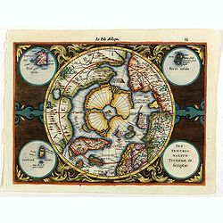
Septentrionalium Terrarum descriptio.
Artic pole map from the rare Cloppenburg edition slightly larger format and more scarce edition of the Mercator/Hondius "Atlas Minor". The classic map of the Ar...
Date: Amsterdam, 1630
Selling price: ????
Please login to see price!
Sold in 2020
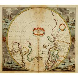
Regiones Sub Polo Arctico.
One of the many cases of duplication by the firms of Blaeu and Hondius/Jansson. In this case, Blaeu has copied Jansson's map of 1637. It depicts rhumb lines radiating fro...
Date: Amsterdam, 1640
Selling price: ????
Please login to see price!
Sold in 2009
Regiones Sub Polo Arctico.
One of the many cases of duplication by the firms of Blaeu and Hondius/Jansson. In this case, Blaeu has copied Jansson's map of 1637. It depicts rhumb lines radiating fro...
Date: Amsterdam 1640
Selling price: ????
Please login to see price!
Sold
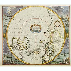
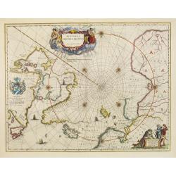
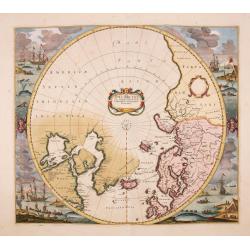
Poli Arctici et Circumiacentium Terrarum Descriptio.
A circular map showing north of Europe and United States. The map is surrounded by scenes of fishing whales. Cartographically the map incorporates much of the knowledge g...
Date: Amsterdam, 1639-1644
Selling price: ????
Please login to see price!
Sold in 2012
Poli Arctici et Circumiacentium Terrarum Descriptio.
A circular map showing north of Europe and United States. The map is surrounded by scenes of fishing whales.
Date: Amsterdam 1639-1644
Selling price: ????
Please login to see price!
Sold
Regiones Sub Polo Arctico.
A fine Blaeu version of the Janssonius map of 1637. It depicts rhumb lines radiating from the North Pole. A large title cartouche, with two figures and numerous wind head...
Date: Amsterdam, 1647
Selling price: ????
Please login to see price!
Sold in 2017
Septentrionalium Terrarum Descript.
Detailed miniature map of the North Pole, from a German text edition of his Atlas Minor. Engraved by Petrus Kaerius.
Date: Amsterdam (1628) 1648
Selling price: ????
Please login to see price!
Sold
Pais qui dependent de la Norvege suivant les derniers relations.
Rare map of the North Pole. With inset maps of Faeroe and Shetland Islands.
Date: Paris 1650
Selling price: ????
Please login to see price!
Sold
Regiones Sub Polo Arctico.
One of the many cases of duplication by the firms of Blaeu and Hondius/Jansson. In this case, Blaeu has copied Janssonius's map of 1637. It depicts rhumb lines radiating ...
Date: Amsterdam, 1650
Selling price: ????
Please login to see price!
Sold in 2025
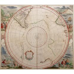
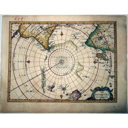
Polus Antarcticus.
Circular map with decorative illustrations in the four corners of the South Pole. From the German text edition of his Atlas of 1650.Third state with important changes: Th...
Date: Amsterdam, 1650
Selling price: ????
Please login to see price!
Sold in 2013
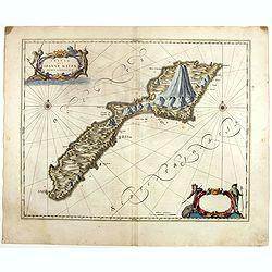
Insula que a Joanne Mayen nomen sortita est.
Jan Mayen is an isolated island in the northern Atlantic, lying between 70-72° North and 8-9° West, about 550 kilometers northeast of Iceland and 500 kilometers east of...
Date: Amsterdam, 1659
Selling price: ????
Please login to see price!
Sold in 2025
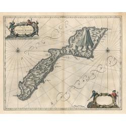
Insula Quae a Ioanne Mayen Nomen Sortita Est.
This remarkable map by Johannes Blaeu depicts the island of Jan Mayen, upon which is located the northernmost volcano on planet Earth, Beerenberg. It is a small island in...
Date: Amsterdam 1659
Selling price: ????
Please login to see price!
Sold in 2023
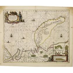
Nova Zemla, Waygats, Fretum Nassovicum, et terra Samoiedum singula ómnium emendatissime descripta.
Shows Novaya Zemlya and northern continental coastline. Includes notes on 1594/95/96 discoveries. Illustrated with sailing ships, sea monsters, various people and animals...
Date: Amsterdam, 1659
Selling price: ????
Please login to see price!
Sold in 2010
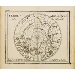
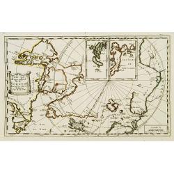
Terres Arctiques.. Septemtrional et Boreales.
Uncommon miniature map of the North Pole, including Iceland, the coast of Russia, Greenland, etc, from Pierre Duval's La Geographie Universeille dated 1676. Following his...
Date: Paris, 1676
Selling price: ????
Please login to see price!
Sold
POLI ANTARCTICI Cum Terris Circumjacentibus Descriptio.
An extremely rare map of the Antarctic region, including most of (then known) Australia and New Zealand, from the last, enlarged, edition of the Mercator / Cloppenburgh A...
Date: Amsterdam, 1676
Selling price: ????
Please login to see price!
Sold in 2021
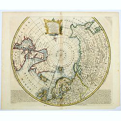
Poli Arctici, et circumiacentium terrarum descriptio novissima. . .
A re-issue of the Hondius' plate, but without the signature. A particularly decorative map of the North Pole. Several Dutch names in Labrador. The toponymy in Canada refl...
Date: Amsterdam, ca.1676
Selling price: ????
Please login to see price!
Sold in 2016
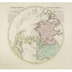
Hemisphere septentrional pour voir plus distinctement les terres arctiques. . .
Showing the Northern Hemisphere with North America, the Arctic, the Pacific, Asia and Europe after the cartographic source by the French map maker Guillaume De Isle. The ...
Date: Amsterdam, c. 1740
Selling price: ????
Please login to see price!
Sold in 2023
A NEW and Accurate Map of the North Pole, with all the Countries hitherto Discovered. . .
A spectacular Arctic and sub-Arctic map, showing excellent detail around Hudson Bay area, Greenland, Spitzbergen & the Northeast Coast of Europe & Asia. It depict...
Date: London, 1748
Selling price: ????
Please login to see price!
Sold in 2021
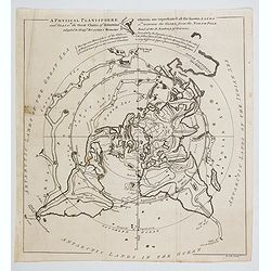
A Physical Planisphere wherein are represented all the known Lands and Seas with the Great Chain of Mountains. . . and Seas in the Great Chains of Mountains. . .
This is an elegant 1757 map of the world represented on an unusual polar projection rendered from the North Pole. The map covers from the North Pole Arctic region south b...
Date: London, 1757
Selling price: ????
Please login to see price!
Sold in 2023
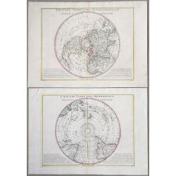
Emisfero terrestre Meridionale Tagliato Su l'Equatore & Emisfero terrestre Settentrionale Tagliato su l'equatore.
Pair of Polar Projections of the Northern & Southern Hemisphere. From: Antonio Zatta, 'Atlante Novissimo, illustrato ed accresciuto sulle osservazioni, e scoperte fat...
Date: Venice, 1779
Selling price: ????
Please login to see price!
Sold in 2022
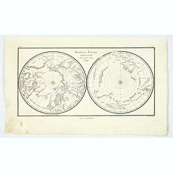
Regioni Polari Paragonate. . .
An unusual item, an Italian map of the poles. Information is confined to mountains, rivers, tracks, and some major cities. Unsurprisingly, there is more information about...
Date: Milano, ca 1810
Selling price: ????
Please login to see price!
Sold in 2021
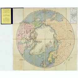
Stanford's Map of the countries round the North Pole.
A scarce example of Edward Stanford’s map depicting the entire Arctic Region. In the Russia section, the map extends until the Caspian Sea.To the left an explanation of...
Date: London, 1875
Selling price: ????
Please login to see price!
Sold in 2024
![[Set of two maps in north and south pole projections, with orographic profile of mountains and oceans, with volcanos with Ottoman script]](/uploads/cache/44325-250x250.jpg)
[Set of two maps in north and south pole projections, with orographic profile of mountains and oceans, with volcanos with Ottoman script]
Two postcard size maps with north and south pole projections, below each map orographic profiles of mountains and oceans, with volcanos. The maps are in Ottoman script pr...
Date: Istanbul, 1325 or 1909
Selling price: ????
Please login to see price!
Sold in 2025
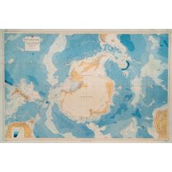
Antarctica. No. 2562. Compiled from all available sources to 1943, including the results of all American exploration from The United States Exploring Expedition, 1839-1840, to The United States Antarctic Service, 1940-1941.
FIRST EDITION. Overall dimensions 85 x 128cm. Original colour printed map of Antarctica, backed onto linen, with the South Pole at the centre, encompassing New Zealand an...
Date: Washington D.C.: Hydrographic Office, under the authority of the Secretary of the Navy. 1943
Selling price: ????
Please login to see price!
Sold in 2023
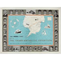
The Times Map Of The Trans-Antarctic Expedition Antarctica South Pole Vivian Fuchs Edmund Hillary.
Original vintage advertising poster - The Times Map of the Trans-Antarctic Expedition 1957-1958 Feature articles by Dr Vivian Fuchs and Sir Edmund Hillary on the Trans-An...
Date: England, 1960
Selling price: ????
Please login to see price!
Sold in 2023
