Browse Listings
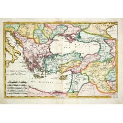
La Turquie d? Europe et celle d?Asie.
Rigobert Bonne (1727-1795), French cartographer. His maps are found in a.o. Atlas Moderne (1762), Raynal's Histoire Philos. du Commerce des Indes (1774) and Atlas Encyclo...
Date: Paris, 1774
Selling price: ????
Please login to see price!
Sold
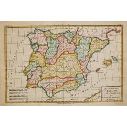
Le Royaume d'Espagne et celui de Portugal.
Rigobert Bonne (1727-1795), French cartographer. His maps are found in a.o. Atlas Moderne (1762), Raynal's Histoire Philos. du Commerce des Indes (1774) and Atlas Encyclo...
Date: Paris, 1774
Selling price: ????
Please login to see price!
Sold
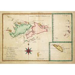
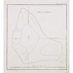
Isles Maidenland, de Hawkins et le Détroit de Falkland. / Isle de Géorgie. / Terre de Sandwich.
Rigobert Bonne (1727-1795), French cartographer. His maps are found in a.o. Atlas Moderne (1762), Raynal's Histoire Philos. du Commerce des Indes (1774) and Atlas Encyclo...
Date: Paris, 1774
Selling price: ????
Please login to see price!
Sold
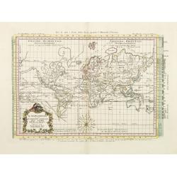
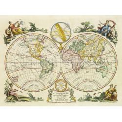
Il Mappamondo o sia Descrizione Generale del Globo Ridotto..
Attractive Italian map presented on Mercator's projection and featuring the voyages of Cook and Bougainville. Greenland is shown connected to North America and Alaska is ...
Date: Venice, 1774
Selling price: ????
Please login to see price!
Sold in 2010
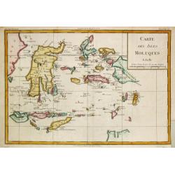
Carte des Isles Moluques.
Rigobert Bonne (1727-1795), French cartographer. His maps are found in a.o. Atlas Moderne (1762), Raynal's Histoire Philos. du Commerce des Indes (1774) and Atlas Encyclo...
Date: Paris, 1774
Selling price: ????
Please login to see price!
Sold in 2009
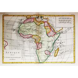
Afrique.
Rigobert Bonne (1727-1795), French cartographer. His maps are found in a.o. Atlas Moderne (1762), Raynal's Histoire Philos. du Commerce des Indes (1774) and Atlas Encyclo...
Date: Paris, 1774
Selling price: ????
Please login to see price!
Sold
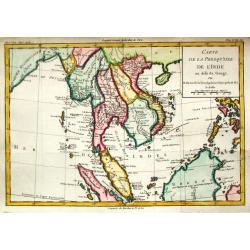
Carte de la Presque' Isle de l' Inde.
Louis Brion de la Tour (1756-1823), ' Atlas Géneral, Civil et Ecclésiastique', 1766, ' Atlas Général', 1790-98. Louis Charles Desnos (fl.1750-70), Le Rouge's 'Atlas N...
Date: Paris, 1774
Selling price: ????
Please login to see price!
Sold
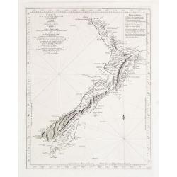
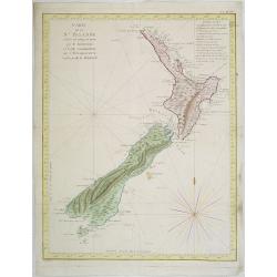
Carte de la Nouvelle-Zelande visitée en 1769 et 1770 par le Lieutenant J. Cook..
Map of New Zealand, engraved by Bernard. The Dutchman Abel Tasman discovered New Zealand in 1642: however it was Cook's circumnavigation of the Islands in 1769 & 1770...
Date: 1774
Selling price: ????
Please login to see price!
Sold
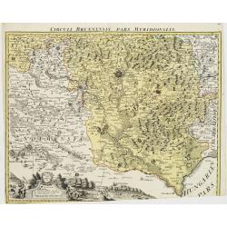
Circuli Brunnensis Pars Meridionalis.
Johann Baptist Homann's well-engraved and detailed map of the present-day South Moravia region centered on Brno, with decorative cartouche at the bottom.Johann Baptist Ho...
Date: Nuremberg 1770 - 1774
Selling price: ????
Please login to see price!
Sold in 2008
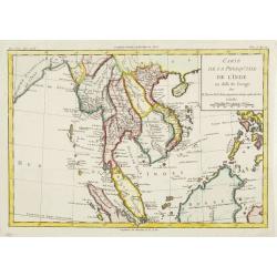
Carte de la Presque' Isle de l' Inde.
A map of Indochina, Thailand, Malaysia, the Philippines and the island of Hainan. Published by Louis Brion de la Tour (1756-1823), and included in his Histoire Universel.
Date: Paris, 1774
Selling price: ????
Please login to see price!
Sold in 2015
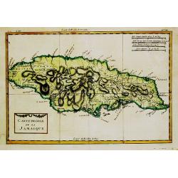
Carte de l''Isle de la Jamaique.
Rigobert Bonne (1727-1795), French cartographer. His maps are found in a.o. Atlas Moderne (1762), Raynal's Histoire Philos. du Commerce des Indes (1774) and Atlas Encyclo...
Date: Paris, 1774
Selling price: ????
Please login to see price!
Sold
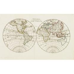
Mappe Monde ou Description du Globe Terrestre.
World map dated 1774, with Russian discoveries but no de la Fuente geography. Tasmania connected to the continent of Australia. From Atlas Portatif Universel, by Robert d...
Date: Paris, 1774
Selling price: ????
Please login to see price!
Sold in 2008
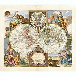
Il Mappamondo o sia Descrizione Generale del Globo
Double-hemisphere world, with allegorical figures of the Four Continents in the corners. Published just after the news of Cook's first circumnavigation was published, his...
Date: Venice, 1774
Selling price: ????
Please login to see price!
Sold in 2011
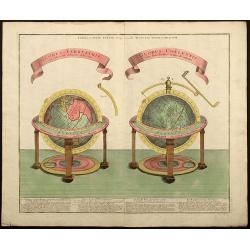
Globus Terrestris ad Sphaeram Obliquam Delineatus / Globus Coelestis cum Astrodictico Artificiali Iunctus.
Hand colored engraving showing terrestrial and celestial globes.
Date: Augsburg, 1774
Selling price: ????
Please login to see price!
Sold in 2008
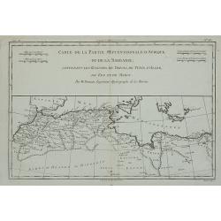
Carte de la Partie Septentrionale d'Afrique ou de la Barbarie, ...
A map showing Africa's Mediterranean coast.Rigobert Bonne (1727-1795), French cartographer. His maps are found in Atlas Moderne (1762), Raynal's Histoire Philos. du Comme...
Date: Paris, 1774
Selling price: ????
Please login to see price!
Sold in 2012
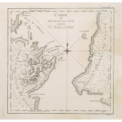
Carte du Detroit de Cook dans la Nle. Zelande. Tome III Pl. 11.
The map depicts Cook\'s Strait, that separates the north and south island of New Zealand. Present day Wellington (NZ\'s capital), Marlborough Sounds, and Cloudy Bay (famo...
Date: Paris, 1774
Selling price: ????
Please login to see price!
Sold in 2008
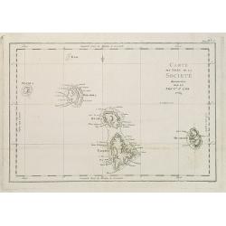
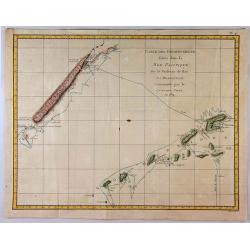
Carte des Isles de la Societé découvertes par le Lieut.t J. Cook 1769.
Map of the islands of Maurua, Bolabola, Otaha, Ulietéa and Huaheine. In upper right corner "Tome III Pl. 1". As James Cook writes in his journal on page 39 : &...
Date: Paris, 1774
Selling price: ????
Please login to see price!
Sold in 2014
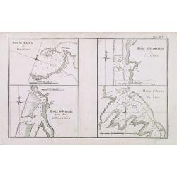
Baye de Matavai a Otahiti / Havre d'Owharre dans l'Isle d'Huaheine / Havre d'Ohamaneno a Ulietea / Havre d'Oopoa a Ulietea. Tome III Pl. 2.
Four maps on one page of the Tahiti islands. Disbound from the first French edition of James Cook's first voyage entitled Relation des voyages entrepris par ordre de sa ...
Date: Paris, 1774
Selling price: ????
Please login to see price!
Sold in 2010
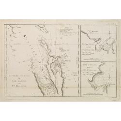
Riviere Tamise et Baye Mercure a la Nle. Zélande / Baye des Isles dans la Nle. Zelande / Baye de Tolaga dans la Nle. Zelande /Tome III Pl. 9.
Nautical map of the Tamise River and the Mercure and Tolaga Bay in New Zealand. This map is taken from the first French edition of James Cook's first voyage entitled Rel...
Date: Paris, 1774
Selling price: ????
Please login to see price!
Sold in 2008
![Port Gallant et Baye Fortescue / Port Eimine /Baye de Wood / Baye et Havre de Cordes. [Tome I Pl. 3.]](/uploads/cache/25889-250x250.jpg)
Port Gallant et Baye Fortescue / Port Eimine /Baye de Wood / Baye et Havre de Cordes. [Tome I Pl. 3.]
Four charts on one sheet of Port Famine, Wood's Bay, Port Gallant and Fortescue Bay, Cordes Bay and Harbour. This print is taken from the first French edition of James Co...
Date: Paris, 1774
Selling price: ????
Please login to see price!
Sold in 2012
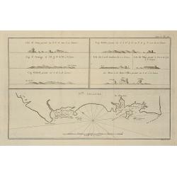
![Carte de Maidenland ou de la Virginie de Hawkins, Découverte par Sir Richard Hawkins en 1574, et du Canal Falkland . . . [Tome I Pl.7.]](/uploads/cache/25892-250x250.jpg)
Carte de Maidenland ou de la Virginie de Hawkins, Découverte par Sir Richard Hawkins en 1574, et du Canal Falkland . . . [Tome I Pl.7.]
Chart shows the Falkland Islands and the Falkland Straits discovered by Sir Richard Hawkins in 1574. Shows many harbors, channels, capes, bays, shoals, islands, rocks, so...
Date: Paris, 1774
Selling price: ????
Please login to see price!
Sold in 2021
![Vue du Côté N.O. de Masafuero. [Tome I Pl. 8.]](/uploads/cache/25893-250x250.jpg)
Vue du Côté N.O. de Masafuero. [Tome I Pl. 8.]
Coastline views of the North West of Masafuero. This print is taken from the first French edition of James Cook's first voyage entitled Relation des voyages entrepris par...
Date: Paris, 1774
Selling price: ????
Please login to see price!
Sold in 2012
![Carte et vues de l'Isle Pitcairn. [Tome I Pl. 9.]](/uploads/cache/25894-250x250.jpg)
Carte et vues de l'Isle Pitcairn. [Tome I Pl. 9.]
Map of the Island of Pitcairn with four profile views. This map is taken from the first French edition of James Cook's first voyage entitled Relation des voyages entrepri...
Date: Paris, 1774
Selling price: ????
Please login to see price!
Sold in 2012
![Isles de la Reine Charlotte. [Tome I Pl. 10.]](/uploads/cache/25895-250x250.jpg)
Isles de la Reine Charlotte. [Tome I Pl. 10.]
Pre Bonne map of Queen Charlotte Islands. This map is taken from the first French edition of James Cook's first voyage entitled Relation des voyages entrepris par ordre d...
Date: Paris, 1774
Selling price: ????
Please login to see price!
Sold in 2010
![N.elle Irlande. [Tome I Pl. 12.]](/uploads/cache/25896-250x250.jpg)
N.elle Irlande. [Tome I Pl. 12.]
Chart of New Ireland. New Ireland is a large island in Papua New Guinea. It is the main and largest island of the New Ireland Province. It lies northeast of the island of...
Date: Paris, 1774
Selling price: ????
Please login to see price!
Sold in 2020
![Carte des Découvertes du Capne Carteret dans la Nle Bretagne. . . . [Tome I Pl. 13.]](/uploads/cache/25897-250x250.jpg)
Carte des Découvertes du Capne Carteret dans la Nle Bretagne. . . . [Tome I Pl. 13.]
An attractive map showing partial outlines of Papua New Guinea and New Britain, the largest island in the Bismarck Archipelago northwest of New Guinea. This map is taken ...
Date: Paris, 1774
Selling price: ????
Please login to see price!
Sold in 2009
![Trois vues des Isles de L'Amirauté. . . [Tome I Pl. 14.]](/uploads/cache/25898-250x250.jpg)
Trois vues des Isles de L'Amirauté. . . [Tome I Pl. 14.]
Coastline profiles of the Admiralty Islands. This map is taken from the first French edition of James Cook's first voyage entitled Relation des voyages entrepris par ordr...
Date: Paris, 1774
Selling price: ????
Please login to see price!
Sold in 2020
![Banc de Sable dangereux / Isles de Jofeph Freewill / L'Extrémité Méridionale de Mindanao. [Tome I. Pl. 15.]](/uploads/cache/25899-250x250.jpg)
Banc de Sable dangereux / Isles de Jofeph Freewill / L'Extrémité Méridionale de Mindanao. [Tome I. Pl. 15.]
Three charts on one page showing the southern tip of Mindanao. This map is taken from the first French edition of James Cook's first voyage entitled Relation des voyages ...
Date: Paris, 1774
Selling price: ????
Please login to see price!
Sold in 2015
Vue de la Baye de Bonthain . . .dans l\'Isle des Celebes. Tome I Pl. 16.
Chart of Bonthain Bay on the Island of Celebes. This map is taken from the first French edition of James Cook\'s first voyage entitled Relation des voyages entrepris par ...
Date: Paris, 1774
Selling price: ????
Please login to see price!
Sold in 2008
![Isle de Sir Charles Saunder. . . / Isle Osnabrug. . . / Isle de l'Amiral Keppel. . . / Isle de Wallis. . . [Tome II Pl. 3.]](/uploads/cache/25901-250x250.jpg)
Isle de Sir Charles Saunder. . . / Isle Osnabrug. . . / Isle de l'Amiral Keppel. . . / Isle de Wallis. . . [Tome II Pl. 3.]
Coastline charts of the Admiralty Islands, near New Guinea. This map is taken from the first French edition of James Cook's first voyage entitled Relation des voyages ent...
Date: Paris, 1774
Selling price: ????
Please login to see price!
Sold in 2014
Isles de Wallis. Tome II Pl. 25.
Chart of the Wallis Islands. Willis Island is an island in an external territory of Australia, located beyond the Great Barrier Reef in the Coral Sea some 420 km east of ...
Date: Paris, 1774
Selling price: ????
Please login to see price!
Sold in 2013
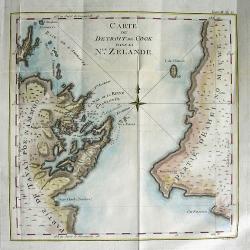
CARTE DU DETROIT DE COOK DANS LA Nle. ZELANDE
Very important map showing Cook\'s Strait, which separates the North and South islands of New Zealand. Present day Wellington, Marlborough Sounds, and Cloudy Bay are depi...
Date: Paris, 1774
Selling price: ????
Please login to see price!
Sold in 2008
Kaart van de Eilanden in den omtrek ran OTAHITI ontdekt op rerfchillende Reizen om de waereld door de Kapiteinen Byron, Wallis, Carteret et Cook in de jaaren 1765, 1767, 1769. N° V.
Map of French Polynesia with the tracks around the island of Tahiti by Captain Byron, Wallis, Carteret and Cook in 1765, 1767 and 1769. This map is taken from the Dutch ...
Date: Paris, 1774
Selling price: ????
Please login to see price!
Sold in 2009
![Entrevue du Commodore Byrou avec les Patagons. [Tome I Pl. 6.]](/uploads/cache/26104-250x250.jpg)
Entrevue du Commodore Byrou avec les Patagons. [Tome I Pl. 6.]
Commodore Byron in talks with the native tribes of Patagonia. From the French edition of James Cook's first voyage entitled Relation des voyages entrepris par ordre de sa...
Date: Paris, 1774
Selling price: ????
Please login to see price!
Sold in 2013
![Quadrupede nommé Kanguroo, trouvé sur la Côte de la Nle. Hollande. [Tome IV Pl. 2.]](/uploads/cache/26109-250x250.jpg)
Quadrupede nommé Kanguroo, trouvé sur la Côte de la Nle. Hollande. [Tome IV Pl. 2.]
Attractive and early print of a Kangaroo, engraved from an oil painting by George Stubbs, a famous 18th century artist working in London, who used as a model a skin broug...
Date: Paris, 1774
Selling price: ????
Please login to see price!
Sold in 2008
Carte de la Nle. Zelande vifitée en 1769 et 1770 par le Lieutenant J. Cook Commandant de l\'Endeavour. . . . Tome III Pl. 7.
Important map of New Zealand showing track of Cooks\' Endeavour with relief shown by hachures and bathymetric soundings. The map is taken from the first French edition f...
Date: Paris, Saillant et Nyon, 1774
Selling price: ????
Please login to see price!
Sold in 2009
Carte d'une partie de la Mer du Sud ...
From the French edition of James Cook's first voyage entitled Relation des voyages entrepris par ordre de sa Majesté Britannique actuellement régnante pour faire des d�...
Date: Paris, 1774
Selling price: ????
Please login to see price!
Sold in 2010
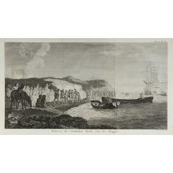
Entrevue du Commodore Byron avec les Patagons.
From the French edition of James Cook's first voyage entitled Relation des voyages entrepris par ordre de sa Majesté Britannique actuellement régnante pour faire des d�...
Date: Paris, 1774
Selling price: ????
Please login to see price!
Sold in 2010
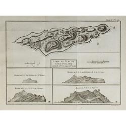
Carte et Vues de l'Isle Pitcairn.
From the French edition of James Cook's first voyage entitled Relation des voyages entrepris par ordre de sa Majesté Britannique actuellement régnante pour faire des d�...
Date: Paris, 1774
Selling price: ????
Please login to see price!
Sold in 2010

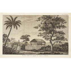
Vue de l'intérieur d'une Maison dans l'Isle d'Ulietéa ...
From the French edition of James Cook's first voyage entitled Relation des voyages entrepris par ordre de sa Majesté Britannique actuellement régnante pour faire des d�...
Date: Paris, 1774
Selling price: ????
Please login to see price!
Sold in 2010
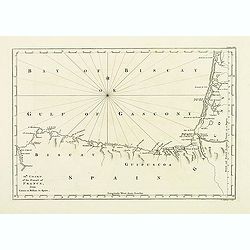
12th Chart of the coast of France from Contis to Bilbao in Spain.
Map of the Gulf of Gascony with Bilbao, st. Sebastian, St. Jean de Luz, Biarritz, Bayonne up to Contis. From his atlas "A Description of the maritime parts of France...
Date: London, 1774
Selling price: ????
Please login to see price!
Sold in 2011
Tome I. Pl. 12 - N.elle Irlande.
From the French edition of James Cook's first voyage entitled Relation des Voyages entrepris par ordre de sa Majesté Britannique, actuellement regnante, pour faire des D...
Date: Paris, 1774
Selling price: ????
Please login to see price!
Sold in 2012
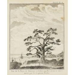
Tome II. Pl. 9 - Vue de la Baye de Matavaï à Otahiti ...
From the French edition of James Cook's first voyage entitled Relation des Voyages entrepris par ordre de sa Majesté Britannique, actuellement regnante, pour faire des D...
Date: Paris, 1774
Selling price: ????
Please login to see price!
Sold in 2012
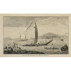
Tome II. Pl. 11 - Vue de l'Isle d'Otahiti et de plusieurs Pirogues.
From the French edition of James Cook's first voyage entitled Relation des Voyages entrepris par ordre de sa Majesté Britannique, actuellement regnante, pour faire des D...
Date: Paris, 1774
Selling price: ????
Please login to see price!
Sold in 2012

Tome II. Pl. 13 - Emouchoir des Otahitiens avec ses manches.
From the French edition of James Cook's first voyage entitled Relation des Voyages entrepris par ordre de sa Majesté Britannique, actuellement regnante, pour faire des D...
Date: Paris, 1774
Selling price: ????
Please login to see price!
Sold in 2012
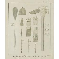
Instruments des Insulaires de la Mer du Sud.
From the French edition of James Cook's first voyage entitled Relation des Voyages entrepris par ordre de sa Majesté Britannique, actuellement regnante, pour faire des D...
Date: Paris, 1774
Selling price: ????
Please login to see price!
Sold in 2011
Tome II. Pl. 16 - Manière dont on expose les morts à Otahiti.
From the French edition of James Cook's first voyage entitled Relation des Voyages entrepris par ordre de sa Majesté Britannique, actuellement regnante, pour faire des D...
Date: Paris, 1774
Selling price: ????
Please login to see price!
Sold in 2012
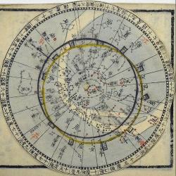
Tensho kanki sho.
Japanese rotating star map. Diameter of the rotatable star map 109mm. Horizon circle 77mm. 24pp."Tensho kanki sho", which means "Brief explanation of astro...
Date: Edo, (Anei 3), 1774
Selling price: ????
Please login to see price!
Sold in 2013
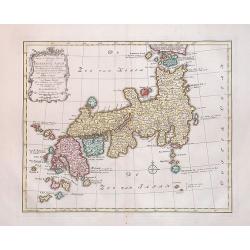
Nieuwe en Naukeurige Kaart van het Keizerryk Japan
A rare, fine decorative map of Japan, with the cartouche on the upper left. In a very good state.The map is of interest for the use of East Sea, the sea between Korea and...
Date: Amsterdam, 1774
Selling price: ????
Please login to see price!
Sold in 2014
Carte de la Nle. Zelande vifitée en 1769 et 1770 par le Lieutenant J. Cook Commandant de l\'Endeavour. . . . Tome III Pl. 7.
Important map of New Zealand showing track of Cooks' Endeavour with relief shown by hachures and bathymetric soundings. The map is taken from the first French edition fr...
Date: Paris, Saillant et Nyon, 1774
Selling price: ????
Please login to see price!
Sold in 2013
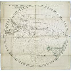
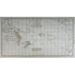
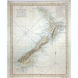
Hémisphere inférieur de la mappemonde projettée sur l'horizon de Paris,. . .
Hemispherical map of Southern Hemisphere showing Australia, New Zealand, islands in the Pacific, most of South East Asia, and the southern half of South America. Australi...
Date: Paris, 1774
Selling price: ????
Please login to see price!
Sold in 2016
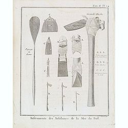
Tome II. Pl. 14 - Instruments des Insulaires de la Mer du Sud.
Taken from the first French edition of James Cook's first voyage entitled Relation des voyages entrepris par ordre de sa Majesté Britannique actuellement régnante pour...
Date: Paris, 1774
Selling price: ????
Please login to see price!
Sold in 2018
Sedes ac Theatrum Bellorum in Regionibus Rheni, Mosae ac Mosellae.
Striking, highly detailed copper engraved map of the Netherlands, Belgium and parts of Germany. Adorned with a large Rococo style double title and scale cartouche. The Lo...
Date: Augsburg, 1774
Selling price: ????
Please login to see price!
Sold in 2016
Nouvelle carte des mers comprises entre le détroit de Banca et P°. Timon avec la partie orientale du détroit de Malacca.
Important French of the tip of Malaysia with Singapore.Latitude and longitude scales, compass rose and system of rhumb lines, soundings near coast and in bay areas.Engra...
Date: Paris, Jean-François Robustel, 1774
Selling price: ????
Please login to see price!
Sold in 2013
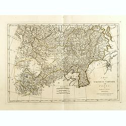
A map of Chinese Tartary with Corea.
The map is of interest for the use of Coreen Sea, the sea between Korea and Japan.Detailed map of China and Korea with Jeso Gasima in the east. Including The Gobi Desert,...
Date: London, 1774
Selling price: ????
Please login to see price!
Sold in 2015
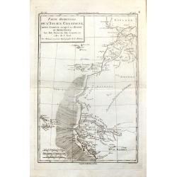
Partie Occidentale de L'Ancien Continent depuis Lisbonne Jusqu'a la Riviere de Sierra Leona.
Fine copper engraved map featuring the west coast of northern Africa and the Madiera, Canary and Cape Verde Island groups. Engraved by Dien for R. Bonne's "RAYNAL'S ...
Date: Paris, 1774
Selling price: ????
Please login to see price!
Sold in 2016
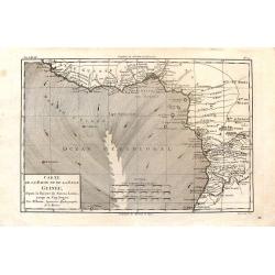
Carte de la Haute et de la Basse Guinee.
Fine copper engraved map featuring the west coast of northern Africa from The Sierra Leone River to Cape Negro. Engraved by Dien for R. Bonne's "RAYNAL'S HISTOIRE PH...
Date: Paris, 1774
Selling price: ????
Please login to see price!
Sold in 2016
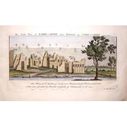
The South View of Easby Abbey near Richmond in York, 1721.
Landscape view of historic castle in Great Britain, original engraved in the early 18th century, and reissued in 1774 as part of a set popularly known as Buck's Antiquiti...
Date: London, 1774
Selling price: ????
Please login to see price!
Sold in 2018
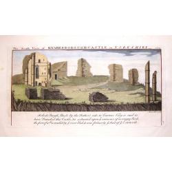
The South View of Knaresborough Castle in Yorkshire, 1721.
Landscape views of historic castles in Great Britain, originally engraved in the early 18th century, and reissued in 1774 as part of Antiquities, a compendium of views of...
Date: London, 1774
Selling price: ????
Please login to see price!
Sold in 2019
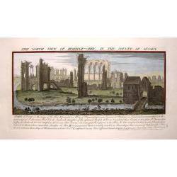
The North view of Begeham Abbey, in the County of Sussex.
Landscape view of historic castle in Great Britain, original engraved in the early 18th century, and reissued in 1774 as part of a set popularly known as Buck's Antiquiti...
Date: London, 1774
Selling price: ????
Please login to see price!
Sold in 2017
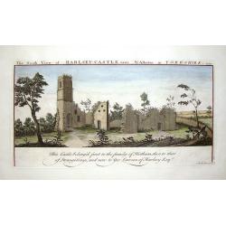
The South View of Harlsey Castle Near N. Allerton in Yorkshire, 1721.
Landscape view of historic castle in Great Britain, original engraved in the early 18th century, and reissued in 1774 as part of a set popularly known as Buck's Antiquiti...
Date: London, 1774
Selling price: ????
Please login to see price!
Sold in 2018
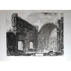
Avanzi di una Sala appartamente al Castro Pretorio nella Villa Adriana in Tivoli.
Original etching from the “Vedute di Roma”, which is the name for a collection of 135 monumental etchings by Giovanni Battista Piranesi. With those etchings he had a ...
Date: Rome, 1774
Selling price: ????
Please login to see price!
Sold in 2014
Il Mappamondo o sia Descrizione Generale del Globo Terrestre ed Acquatico.
Double-hemisphere world, with allegorical figures of the Four Continents in the corners. Published just after the news of Cook's first circumnavigation was published, his...
Date: Venice, 1774
Selling price: ????
Please login to see price!
Sold in 2015
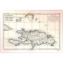
Carte de L'Isle de St. Domingue une des Grande Antilles
A copperplate map of the island of Hispaniola by Rigobert Bonne in 1774. With the two sovereign states of the Dominican Republic and Haiti. Also with nearby Caicos and th...
Date: Paris, 1774
Selling price: ????
Please login to see price!
Sold in 2017
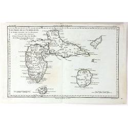
Les Isles de la Guadeloupe, de Marie Galante, de la Désirade et Celles des Saintes...
A map of the French island of Guadeloupe, together with the islands in the vicinity, by Bonne, published in Paris in 1774. Engraved by Dien.Rigobert Bonne (1727-1795), wa...
Date: Paris, 1774
Selling price: ????
Please login to see price!
Sold in 2020
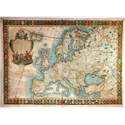
L'Europe Divisee Dans Ses Principaux Etats
A large, striking example of the 1774 edition of the Guillaume Danet, a very decorative map of Europe, surrounded as it is by 110 coats of arms, showing the various state...
Date: Paris, 1774
Selling price: ????
Please login to see price!
Sold in 2016
![Globus Terrestris ad Sphaeram Obliquam Delineatus . . . [together with] Sphaera Armillaris / Instrumentum artificiale Orrery ab inventore appellatum . . .](/uploads/cache/38022-250x250.jpg)
Globus Terrestris ad Sphaeram Obliquam Delineatus . . . [together with] Sphaera Armillaris / Instrumentum artificiale Orrery ab inventore appellatum . . .
A beautiful matching set of two decorative prints of a Terrestrial and a Celestial pair of globes, together with an Armillary sphere and an Ornery. Globus Terrestris ad S...
Date: Augsburg 1774
Selling price: ????
Please login to see price!
Sold in 2016
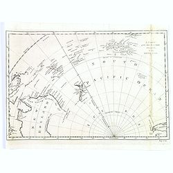
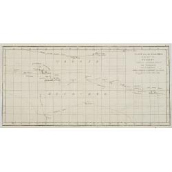
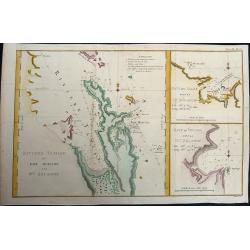
A Chart of the New Discover'd Islands, in the South Seas.
A scarce chart of the newly discovered islands located in the south Pacific, in the latter half of the eighteenth century. Map shows the southern most tip of South Americ...
Date: London, ca. 1774
Selling price: ????
Please login to see price!
Sold in 2017
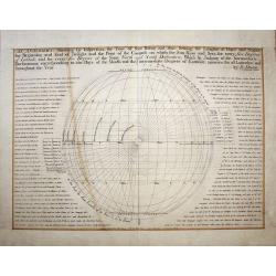
“An Analemma Shewing by Inspection the Time of Sun Rising and Sun Setting, the Lengths of Days and Nights, Beginning and End of Twilight and the Point of the Compass on which the Sun Rises and Sets, for every Five Degrees of Latitude and for every five De
An interesting engraving of an 'ANALEMMA', a "pedestal of a sundial", Showing the time of sun rising and sun setting, the lengths of days and nights the beginni...
Date: London, 1774
Selling price: ????
Please login to see price!
Sold in 2017
Carte des Decouvertes Faites dans la Mer Pacifique sur le Vaiseau de Poi La Resolution Commande par le Capitaine Cook en 1774.
This fine copper engraved map shows New Caledonia Island in the upper left, and the New Hebrides in the lower right. The map is west oriented so that north is on the righ...
Date: London, 1774
Selling price: ????
Please login to see price!
Sold in 2018
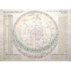
The Principal Fixed Stars of the South Hemisphere Delineated on the Plane of the Equator.
An interesting celestial chart of thirty principal fixed stars for the year 1774. The table on the left gives the variations and declinations for future years. Includes t...
Date: London, 1774
Selling price: ????
Please login to see price!
Sold in 2018

Special Carte von dem Netz und Warthe Bruche nebst daran gränzenden Landsbergschen gantzen, wie auch einem theile des Friedeberg und Königsbergschen Creises.
A MORE THAN 2 METERS MANUSCRIPT MAP OF WEST-CENTRAL POLANDIn top a large compass rose and south is interestingly oriented to the top. The river Oder is to the utmost righ...
Date: Poland, 1774
Selling price: ????
Please login to see price!
Sold
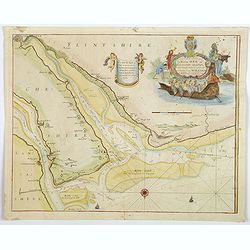
A New and Exact Survey of the River Dee or Chester-Water. . .
An English sea chart by Grenville Collins, depicting (in part) the coastlines and sands of The Wirral, Cheshire, Lancashire and Flintshire, and the River Dee estuary. The...
Date: London, ca 1774
Selling price: ????
Please login to see price!
Sold in 2020
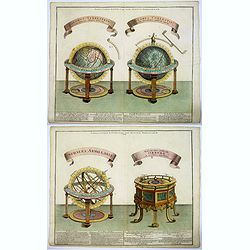
Sphaera Armillaris /.. Orrery (and) Globus Terrestris../ Globus Coelestis. . .
A beautiful matching set of two decorative prints of an Armillary sphere and an Orrery, plus a Terrestrial and a Celestial pair of globes. Along the bottom portion is a d...
Date: Augsburg 1774
Selling price: ????
Please login to see price!
Sold in 2021
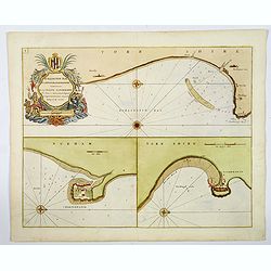
Burlington Bay, Scarborough & Hartlepool.
An impressive sea chart of the north England areas of Hartlepool, Scarborough and Burlington Bay. From Greenville Collins, the Hydrographer to the King (George III), from...
Date: London, ca 1774
Selling price: ????
Please login to see price!
Sold in 2019
Riviere Tamise et Baye Mercure a la Nle. Zélande.
Baye des Isles dans la Nle. Zelande / Baye de Tolaga dans la Nle. Zelande /Tome III Pl. 9.. A nautical map of the Tamise River and the Mercure and Tolaga Bay in New Zeala...
Date: Paris, 1774
Selling price: ????
Please login to see price!
Sold in 2019
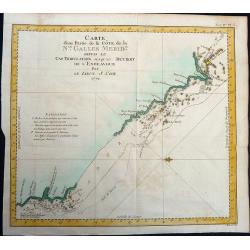
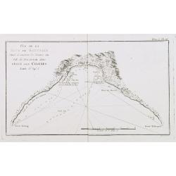
Carte d'une Partie de la Côte, de la Nle Galles Meridle depuis le Cap Tribulation jusqu'au Detroit de l'Endeavour par le Lieut. J. Cook 1770.
Map of a part of the New Galles Meridle Coastline in Australia from the Cap Tribulation to the Endeavour Detroit. This map is taken from the first French edition of James...
Date: Paris, 1774
Selling price: ????
Please login to see price!
Sold in 2021
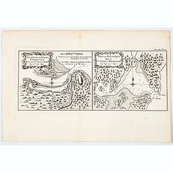
Entree de la Riviere Endeavour dans la Nle. Galles Meridle. . . / Baye de Botanique dans la Nle. Galles Meridionale. . .
Two maps of eastern of Australia, the entrance to the Endeavour River, and a map of Botany Bay, both in New South Wales, from the French edition of Cook, engraved by Robe...
Date: Paris, 1774
Selling price: ????
Please login to see price!
Sold in 2021
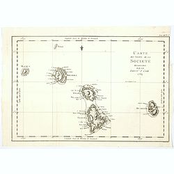
Carte des Isles de la Societe decouvertes par le Lieut. J. Cook 1769.
A nice and detailed map of the Society Islands, based upon the contemporary surveys by Captain James Cook during his first voyage. As can be seen in the tile, this map ap...
Date: Paris, 1774
Selling price: ????
Please login to see price!
Sold in 2020
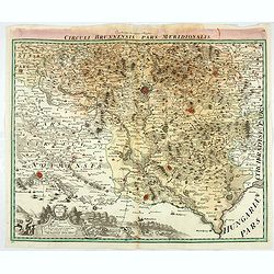
Circuli Brunnensis Pars Meridionalis.
Johann Baptist Homann's well-engraved and detailed map of the present-day South Moravia region centred on Brno, with decorative cartouche at the bottom.Johann Baptist Hom...
Date: Nuremberg 1770 - 1774
Selling price: ????
Please login to see price!
Sold in 2020