Browse Listings
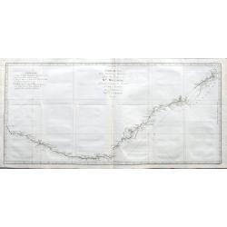
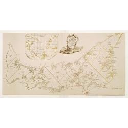
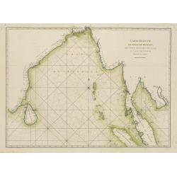
Carte de la Nle. Galles Merid.le ou de la Cote Orientale de la Nle. Hollande Découverte et visiteé par le Lieutenant J. Cook, Commandant de l'Endeavor. . .
One of Cook's most famous charts, the important first map of New South Wales, Australia. Oriented with north to the right side, and it extends from Point Hicks and Cape H...
Date: Paris, ca 1774
Selling price: ????
Please login to see price!
Sold in 2021
-250x250.JPG)
Carte d'une partie de la Mer du Sud Contenant les Découvertes des Vaisseaux de sa Majesté...
Complete title : "Carte d'une partie de la Mer du Sud Contenant les Découvertes des Vaisseaux de sa Majesté le Dauphin, Commodore Byron, La Tamar, Capit.ne Mouats,...
Date: 1774
Selling price: ????
Please login to see price!
Sold in 2022
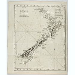
Carte de la Nouvelle-Zelande visitée en 1769 et 1770 par le Lieutenant J. Cook.
Original French Edition of James Cook's Chart of New Zealand, from the First French Edition of Hawkesworth's Voyages. Map of New Zealand, engraved by Bernard. The most im...
Date: Paris, 1774
Selling price: ????
Please login to see price!
Sold in 2024
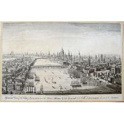
A General View of the City of London, next the River Thames | Vue Generale de la Ville de Londres, du côté de la Tamise.
Rare bird's eye view of London with an imense amount of details, buildings, ships, etc. Shows the Tower on the right, old London Bridge in the centre with the Monument to...
Date: London, 1775
Selling price: ????
Please login to see price!
Sold in 2019
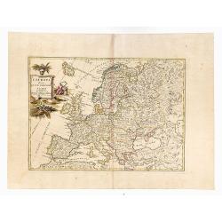
L'Europa divisa Ne Suoi Principali Stati.
Original outline color, with decorative colored title cartouche to upper left corner. Double page map of Europe. Blank on verso.
Date: Venice, 1775
Selling price: ????
Please login to see price!
Sold in 2020

Quadrupede nomme Kanguroo, trouve sur la Cote de la Nouvelle Hollande.
An illustration from the French publication of John Hawkesworth’s "Account of the Voyages undertaken…for making discoveries in the Southern Hemisphere" (Lon...
Date: Paris, ca 1775
Selling price: ????
Please login to see price!
Sold in 2020
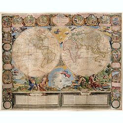
Le Globe Terrestre represente en deux plans-hemispheres dresee. . .
A very fine example of the Jean-Baptiste Crepy version of Jean Baptiste Nolin's striking large wall map of the World. The present example represents the 1775 state of the...
Date: Paris, 1775
Selling price: ????
Please login to see price!
Sold in 2020
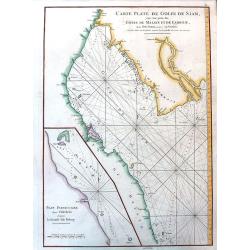
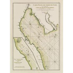
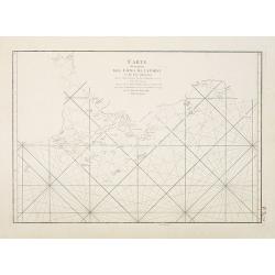
Carte Plate du Golfe de Siam avec une Partie des Côtes de Malaye et de Camboje, depuis l'Isle Timon, jusqu'a celle Condor.
A detailed sea chart of the Gulf of Siam. It extends from Bangkok until Timon (Malaysia) and in the east until the Mekong Delta. Filled with depth soundings and rhumb lin...
Date: Paris, ca.1775
Selling price: ????
Please login to see price!
Sold in 2020
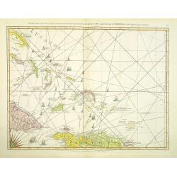
LESSER ANTILLES,- Carte réduite des îles Antilles au nord du 13me. degré de latitude.. / TURKS-CAICOS-BAHAMAS,- Carte réduite des debouquements de St. Domingue..
Two engraved maps together on one large sheet, the first covering the Leeward Islands from Puerto Rico to Barbados, the second showing the Turks and Caicos Islands and so...
Date: Paris, 1775
Selling price: ????
Please login to see price!
Sold in 2022
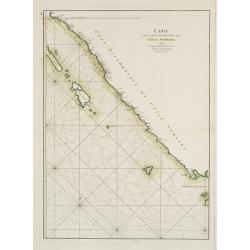
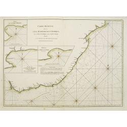
Carte Reduite de la Cote meridionale d' Afrique, depuis La Baye de Saldagne jusqu'au Cap des Courans.
A French sea chart of the southeast coast of South Africa from the 'Atlas Neptune Oriental' of 1775. It extends from Saldanha Bay to north of Cape Courans, including the ...
Date: Paris, Brest, 1775
Selling price: ????
Please login to see price!
Sold in 2021
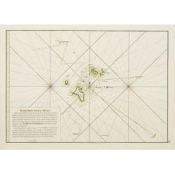
Carte des Isles Nicobar... (with) Plan particulier du Port compris entre les Isles Nacaveri, Souri, et Tricutte.
French chart of Isles of Nicobar in Gulf of Bengal near Birmanie and Sumatra. Prepared by Jacques-François L'Abbé Dicquemare (1733-1789). Latitude and longitude scales,...
Date: Paris, Brest, chez Demonville, 1775
A Map of the Island of St. John in the Golf of St. Laurence
Based on the surveys of Captain Samuel Holland. Published in Thomas Jefferys' "The American Atlas." Detailed map with compass roses and system of rhumb lines, s...
Date: London 1775
Selling price: ????
Please login to see price!
Sold
![[Carte Réduite Des Îles Antilles..] & [Carte Réduite Des Debouquements De St. Domingue..]](/uploads/cache/23048-250x250.jpg)
[Carte Réduite Des Îles Antilles..] & [Carte Réduite Des Debouquements De St. Domingue..]
A well engraved and highly detailed two-in-one chart of the Lesser Antilles (from the eastern tip of Puerto Rico to St. Vincent and Barbados) and of the Turks and Caicos ...
Date: Paris, 1775
Selling price: ????
Please login to see price!
Sold
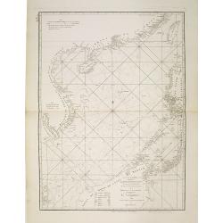
Carte d'une partie des Côtes de la Chine et des Isles adjacentes depuis l'Isle nommée la Pierre Blanche, jusqu'à celle de l'Artimon.
Most important milestone chart based upon the surveys made from navigational surveys and soundings in 1754, 1759, and 1760 by Alexander Dalrymple. This edition of Dalrymp...
Date: Paris, ca 1775
Selling price: ????
Please login to see price!
Sold
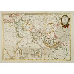
Kaart ter opheldering der geschiedenis.. koophandel..
Attractive and uncommon map covering Asia and Australia, also the east coast of Africa. Engraved by Pieter Mol. The map is copied after Bonne, who is given credit in the ...
Date: Amsterdam 1775
Selling price: ????
Please login to see price!
Sold
Kaart van 't Eyland Amboine.
An uncommon map of the island of Ambon.
Date: Almelo, 1775
Selling price: ????
Please login to see price!
Sold in 2009

Vue du Port de la Ville de Lamekk dans Larabie heureuse à 5 lieues de la Mer Rouge.
Imaginary optic vue of Mecca's harbor.
Date: Paris 1730-1775
Selling price: ????
Please login to see price!
Sold in 2008
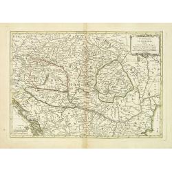
Le Royaume de Hongarie, Divisé en Haute et Basse Hongrie Transilvanie Esclavonie et Croatie. . .
Map of Hungary, part of Poland, Bosnia, Serbia, Bulgaria, prepared by Janvier. From Jean Lattré, "Atlas Moderne ou Collection de Cartes sur Toutes les Parties du Gl...
Date: Paris, 1775
Selling price: ????
Please login to see price!
Sold in 2011
Carte Plate de la partie Septentrionale du Détroit de Malac depuis la Rade d'Achem jusqu'à Malac.
French of the Island of Sumatra and the Malay Peninsula separated by the strait of Malacca in Indonesia. Latitude and longitude scales, compass rose and system of rhumb ...
Date: Paris, ca 1775
Selling price: ????
Please login to see price!
Sold
Carte Plate de la Côte Occidentale de l'Isle de Sumatra?
French chart of the north west coast of the island of Sumatra.Latitude and longitude scales, compass rose and system of rhumb lines, soundings near coast and in bay areas...
Date: Paris, ca 1775
Selling price: ????
Please login to see price!
Sold
Carte de la Côte occidentale de l'Isle de Sumatra. . .
French of the lower west coast of Sumatra. Latitude and longitude scales, compass rose and system of rhumb lines, soundings near coast and in bay areas.D' Après de Mann...
Date: Paris, ca 1775
Selling price: ????
Please login to see price!
Sold
Carte du Détroit de la Sonde depuis la Pointe de winerou jusqu'à l'Isle du Nord.Plan de la Baye de l'Ile de Mew ou Cantaye?
French chart of Sunda Street with the southeast cost of Sumatra and the western tip of Java.Latitude and longitude scales, compass rose and system of rhumb lines, soundin...
Date: Paris, ca 1775
Selling price: ????
Please login to see price!
Sold in 2008

Carte de l\'Isle de Java avec les Isles de Banca, de Biliton, et une partie de cellesd de Sumatra et de Bornéo.
French chart of the Island of Java, Banca, Billiton, and part of Sumatra and Borneo.Latitude and longitude scales, compass rose and system of rhumb lines, soundings near ...
Date: Paris, ca 1775
Selling price: ????
Please login to see price!
Sold in 2008
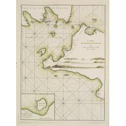
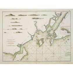
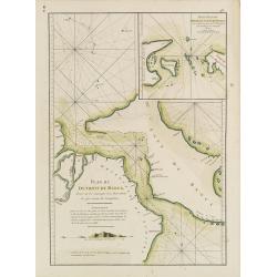
Plan du Port de Rio situé au détroit de Malaca en l'Isle de Bintam. / Plan du Détroit du Gouverneur.
Two French charts on one sheet, to the left a chart of the bay around Batam center on the little island Batam, opposite Singapore. With a lettered key. The chart to the r...
Date: Paris, ca 1775
Selling price: ????
Please login to see price!
Sold in 2012
Carte Plate du Golf du Siam avec une partie des Côtes de Malaye et de Camboje depuis l'Isle Timon, jusqu'à celle Condor./ Plan particulier depuis l'Isle Brala jusqu'à la Grande Isle Ridang.
French chart of the gulf of Siam with Malaysia and Cambodia. With inset chart : Plan particulier depuis l'Isle Brala jusqu'à la Grande Isle Ridang. The chart has some ad...
Date: Paris, ca 1775
Selling price: ????
Please login to see price!
Sold
Carte réduite du Golfe du Bengale depuis l'Isle de Ceylan jusqu'au Golf du Siam?
French chart of Gulf of Bengal. Including the east coast of India with Sri Lanka and the Malay Peninsular till Malacca, Cambodia. Latitude and longitude scales, compass r...
Date: Paris, ca 1775
Selling price: ????
Please login to see price!
Sold
Carte de la Baye et du Port de Trinquemalay Dans L'Isle de Ceylan.
French chart of the harbour of Trinquemalay on the island of Ceylon. Prepared after Samuel Cornish who was a vice admiral for the English East India company.Latitude and ...
Date: Paris, ca 1775
Selling price: ????
Please login to see price!
Sold
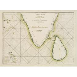
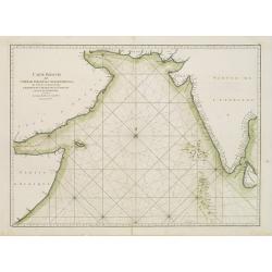
Carte Plate qui comprend l'Isle de Ceylan, une partie des Côtes de Malabar et de Coromandel.
French chart of Ceylon and southern part of India. Latitude and longitude scales, compass rose and system of rhumb lines, soundings near coast and in bay areas.D' Après ...
Date: Paris, ca 1775
Selling price: ????
Please login to see price!
Sold
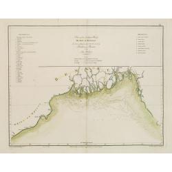
Chart of the Northern Part of the Bay of Bengal.. Plan de la Rivière de Surate.
French chart of the northern part of the bay of Bengal. Laid down from the surveys made by Bartholomen Plaisted and John Ritchie. Milestone chart prepared by Alexander Da...
Date: Paris, ca 1775
Selling price: ????
Please login to see price!
Sold
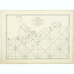
Carte réduite de l'Océan Oriental Septentrional qui contient une partie des Côtes d'Afrique, de l'Arabie, de la Perse et celles de l'Indostan.
French of the coast of Indian ocean with a part of Africa, of Arabia of Persia, of India. Latitude and longitude scales, compass rose and system of rhumb lines, sounding...
Date: Paris, ca 1775
Selling price: ????
Please login to see price!
Sold
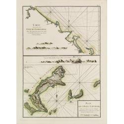
Carte d'une partie de la Côte de Cochinchine depuis l'Isle Cham-Collan jusqu'à la Rive du Roi.Plan de l'Isle Condor
French chart of the Cochinchine coast and the Condore Islands. Latitude and longitude scales, compass rose and system of rhumb lines, soundings near coast and in bay area...
Date: Paris, ca 1775
Selling price: ????
Please login to see price!
Sold
Nouvelle Carte des Mers Comprises entre le Détroit de Banca et P. . . Timon, avec la partie Orientale du Détroit de Malac.
French of the East Coast of Sumatra, the eastern portion of the Strait of Malacca, and the coast of Malaysia, showing strait Banca and island of Pulo Timon. Singapore me...
Date: Paris, ca 1775
Selling price: ????
Please login to see price!
Sold in 2011
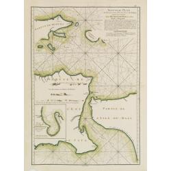
Carte pour aller du Détroit de la Sonde ou de Batavia au Détroit de Banca.
French of the coast of East Sumatra and North-West part of Java. With inset chart Plan des Isles Remouw, Kandang, High et Voody, situées au Sud-Est de l'Isle de Sumatra...
Date: Paris, ca 1775
Selling price: ????
Please login to see price!
Sold in 2019
Plan du Détroit de Banca.. / Petit plan du Détroit à l'Est de Banca.
French detailed of the straits between Sumatra and Bangka. With inset : Petit plan du Détroit à l'Est de Banca.. The chart is an updated version of an earlier copper p...
Date: Paris, ca 1775
Selling price: ????
Please login to see price!
Sold in 2019
Nouveau Plan des Détroits, situés à l'Est de Java et de Madura, nommmés communément les Détroits de Bali et d'entre Pondi et Respondi..
French chart of straits of Bali. With eastern tip of Java, part of Madura and western tip of Bali. Inset chart of harbour of Ballembouang. The chart is giving credit to t...
Date: Paris, ca 1775
Selling price: ????
Please login to see price!
Sold
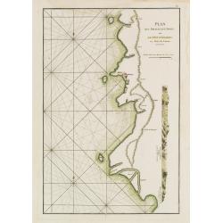
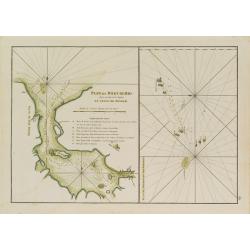
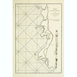
Plan des Principaux Ports de la Côte d'Illocos en l'Isle de Lucon.
French sea chart of a small part of the northwest coast of the Philippines main island of Luzon. Latitude and longitude scales, compass rose and system of rhumb lines, so...
Date: Paris, ca 1775
Selling price: ????
Please login to see price!
Sold in 2008
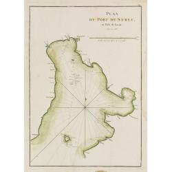
Plan du Port de Subec en l'Isle de Luçon.
French sea chart of Subic Bay and the town of "Subec". Latitude and longitude scales, compass rose and system of rhumb lines, soundings near coast and in bay ar...
Date: Paris, ca 1775
Selling price: ????
Please login to see price!
Sold
![Planisphere celeste Septentrional. . . [together with] Planisphere celeste Meridinale. . .](/uploads/cache/22228-250x250.jpg)
Planisphere celeste Septentrional. . . [together with] Planisphere celeste Meridinale. . .
A pair of celestial charts depicting the constellations of the Northern and Southern hemispheres. Designed by Gabriel Philllipe de la Hire (1640-1719). The center point o...
Date: Paris, 1775
Selling price: ????
Please login to see price!
Sold
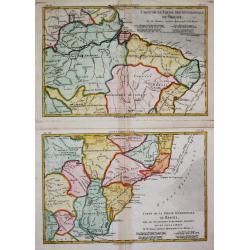
Carte de la Partie Septentrionale / Méridionale du Brésil.
Rigobert Bonne (1727-1795), French cartographer. His maps are found in a.o. Atlas Moderne (1762), Raynal's Histoire Philos. du Commerce des Indes (1774) and Atlas Encyclo...
Date: Paris, c, 1775
Selling price: ????
Please login to see price!
Sold

Quos ego. Sed motos praestat componere fluctus : Eneid. Virg. Lib.I.
Frontispiece from Le Neptune Oriental by D'Après de Mannevillette, famous French sailor and hydrograph. Engraved by J.B. Tilliard after F. Boucher.It illustrates an epis...
Date: Paris 1775
Selling price: ????
Please login to see price!
Sold
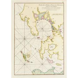
Plan de la baye et Ville de Manille, Capitale des Isles de Philippines.
French sea chart of the inlet and city of Manille. Prepared by Jacques-François L'Abbé Dicquemare (1733-1789). Latitude and longitude scales, compass rose and system of...
Date: Paris, ca 1775
Selling price: ????
Please login to see price!
Sold in 2009
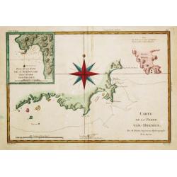
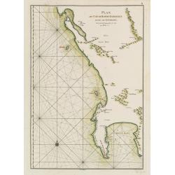
Carte de la Terre Van-Diemen,. . .
A map of the southernmost part of Tasmania with Storm Bay and S. E. Cape. With an inset with Adventure Bay.
Date: Paris, c. 1775
Selling price: ????
Please login to see price!
Sold in 2009
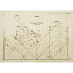
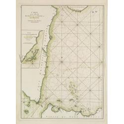
Carte Plate de la Cote Occidentale de l'Isle Sumatra depuis la Riviere de Touroumane jusqu'a la Pointe d'Indrapour...
Highly detailed and large sea-chart showing a part of the Sumatran westcoast. With numerous depth soundings and anchor places, showing even the smallest shoals, to help n...
Date: Paris, c1775
Selling price: ????
Please login to see price!
Sold in 2008
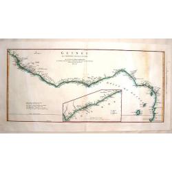
Guinee Entre Serre-Lione et le Passage de la Ligne.
Copper engraved map of the coast of the West African country of Guinee between Serre-Leone and the Equator. This was one of the top sources of slaves during the Historica...
Date: Paris, 1775
Selling price: ????
Please login to see price!
Sold in 2014
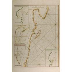
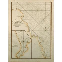
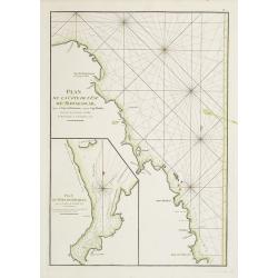
Carte de la Cote orientale de Madagascar, depuis la Pointe de l'Est jusques et compris le Lac Nossé Bé.
Large colored sea of Madagascar. Showing the northeast coastline of Madagascar and four inset maps of the harbours and anchorage of Tamatave, Foulpointe, Teintingue und ...
Date: Paris, 1775
Selling price: ????
Please login to see price!
Sold in 2015
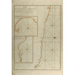
Carte de la Cote orientale de Madagascar depuis Mananzari jusques et compris l'anse du Fort Dauphin.
Large colored sea of Madagascar. Showing the southeast coastline of Madagascar and two inset maps of the harbours and anchorage of Tolanaro and the islands of Saite Luce...
Date: Paris, 1775
Selling price: ????
Please login to see price!
Sold in 2015
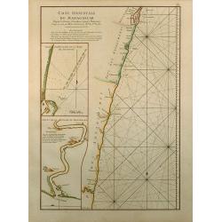
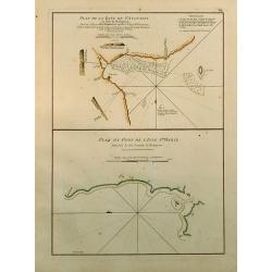
Cote Orientale de Madagascar Depuis la Riviere d'Ivondrou jusque Mananzari.
Finely colored sea of Madagascar. Showing the east coastline of Madagascar and two inset maps of the harbour and anchorage of Manourou and the River Mananzari titled Pla...
Date: Paris, 1775
Selling price: ????
Please login to see price!
Sold in 2015
Plan de la Cote de L'Est de Madagascar, depuis la Baye de Vohemare jusqu'au Cap d'Ambre
Original colored sea of Madagascar. Showing the east coastline of Madagascar and one inset map titled Plan du Port de Louquez. From the second revised and enlarged editi...
Date: Paris, 1775
Selling price: ????
Please login to see price!
Sold in 2015
Plan de la Baye de St. Augustin en l'Isle de Madagascar / Plan du Port de l'Isle Ste. Marie.
Two finely colored plans of Madagascar on one sheet. Showing St. Augustin and the port of the island Ste. Marie at the east coast of Madagascar. From the second revised a...
Date: Paris, 1775
Selling price: ????
Please login to see price!
Sold in 2015
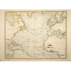
A Chart of the Atlantic Ocean. 1 sheet.
A very fine chart centered on the Atlantic ocean, including a part of western Europe and America continent. London: Printed and sold by Robert Sayer, No. 53 in Fleet Stre...
Date: London, 1775
Selling price: ????
Please login to see price!
Sold in 2008
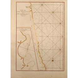
Côte de L'Isle Madagascar depuis la Baye de Vohemare jusqu'à la Pointe de l'Est.
Finely colored sea chart of Madagascar. Showing the east coastline of Madagascar and one inset maps of the Cap de l'Est titled Plan du Port et de la Baye du Cap de l'Est....
Date: Paris, 1775
Selling price: ????
Please login to see price!
Sold in 2015
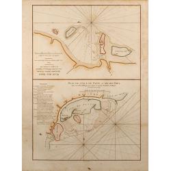
Plan de l'Isle de Patte et de son Port / Plan des Isles Querimbo, Oybo et Matemo.
Two finely colored sea charts of the coast of Africa on one sheet. Showing several Islands at the coast of Kenya and Mozambique. From the second revised and enlarged edit...
Date: Paris, 1775
Selling price: ????
Please login to see price!
Sold in 2015
Plan des Principaux Ports de la Côte d'Illocos en l'Isle de Lucon.
French sea of a small part of the northwest coast of the Philippines main island of Luzon. Latitude and longitude scales, compass rose and system of rhumb lines, soundin...
Date: Paris, Brest, Demonville, 1775
Selling price: ????
Please login to see price!
Sold in 2014
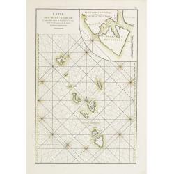
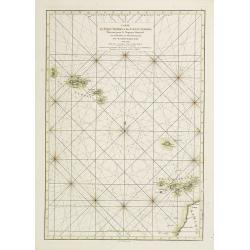
Carte réduite de l'Archipel du Nord-Est de l'Isle Madagascar depuis la lingne Equinoctiale jusqu'au 21d.30m. de Latitude Méridionale
Superb large original sea chart of the Indian Ocean by Mannevillette. Very detailed and large scale, showing the North of Madagascar with many place names, the Seychelle...
Date: Paris, 1775
Selling price: ????
Please login to see price!
Sold in 2011
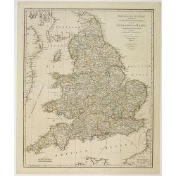
Itinéraire anglois containing the great, direct and cross roads, through England and Wales. . .
Uncommon and detailed map of England and Wales.
Date: London, Sayer and Bennett, 1775
Selling price: ????
Please login to see price!
Sold in 2011
Carte d'une partie des Côtes de la Chine et des Isles adjacentes depuis l'Isle nommée la Pierre Blanche, jusqu'à celle de l'Artimon.
Most important milestone chart based upon the surveys made from navigational surveys and soundings in 1754, 1759, and 1760 by Alexander Dalrymple. This edition of Dalrymp...
Date: Paris, ca. 1775
Selling price: ????
Please login to see price!
Sold in 2010
A chart of the China Sea inscribed to Monsr. D'APRES de MANNEVILLETTE .. To A.Dalrymple.
Most important milestone based upon the surveys made from navigational surveys by Alexander Dalrymple (1737-1808]. He was the first Hydrographer of the British Admiralty...
Date: Paris, ca. 1775
Selling price: ????
Please login to see price!
Sold
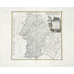
L'Estremadura di Portogallo Alentejo, ed Algarve. . .
Map of the regions of Algarve and Alentejo of Southwestern Portugal by Antonio Zatta. The city of Lisbon is depicted along the western coast, as are the other towns, vill...
Date: Venice, 1775
Selling price: ????
Please login to see price!
Sold in 2010
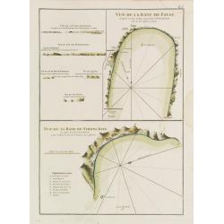
Vue de la Baye de False / Vue de la Rade de Simons-Baye. Vue du Cap des Aiguilles. Vue du Cap des Hottentots. Vue du Cap de Bonne Espérance.
Three French of Cape of Good Hope. Each chart has in addition profiles and a lettered key.Latitude and longitude scales, compass rose and system of rhumb lines, sounding...
Date: Paris, ca. 1775
Selling price: ????
Please login to see price!
Sold in 2012
Plan du Cap de Bonne-Espérance et de ses Environs.
French of Cape of Good Hope.Latitude and longitude scales, compass rose and system of rhumb lines, soundings near coast and in bay areas.D' Après de Mannevillette (1707...
Date: Paris, ca. 1775
Selling price: ????
Please login to see price!
Sold in 2015
Carte des Isles Açores et des Isles Canaries, Dressée pour le Neptune Oriental
French of Canaries Islands and the Azores.Latitude and longitude scales, compass rose and system of rhumb lines, soundings near coast and in bay areas.D' Après de Manne...
Date: Paris, Brest, chez Demonville, 1775
Selling price: ????
Please login to see price!
Sold in 2012
Carte Réduite de l'Océan Orientale qui Contient la Côte d'Afrique, Avec l'Isle Madagascar et les Isles adjacentes.
French of South Africa with Cape Town and part of the south east coast . Insets of "Mossel Bay", "Plan de la rade st.Blaise" and "Plan de la Bay...
Date: Paris, Brest, chez Demonville, 1775
Selling price: ????
Please login to see price!
Sold in 2013
Plan de la Côte de l'Est de Madagascar, depuis la Baye de Vohemare jusqu'au Cap d'Ambre. Plan du Port de Louquez.
French of the north east coast of Madagascar. With inset chart of the harbor of Louquez, discovered in October 1773.Latitude and longitude scales, compass rose and syste...
Date: Paris, Brest, chez Demonville, 1775
Selling price: ????
Please login to see price!
Sold
Plan des Iles de Mahé
From the second edition. French of Isle of Mahé in Seychelles. Prepared by Jacques-François L'Abbé Dicquemare (1733-1789). Latitude and longitude scales, compass rose...
Date: Paris, Brest, chez Demonville, 1775
Selling price: ????
Please login to see price!
Sold in 2014
Plan de la Rade d'Achem et des Isles Circonvoisines Situées à la partie Nord-ouest de Sumatra.
French large nautical of the Archem coast on the northwestern point of Sumatra.Latitude and longitude scales, compass rose and system of rhumb lines, soundings near coas...
Date: Paris, Brest, chez Demonville, 1775
Selling price: ????
Please login to see price!
Sold in 2019
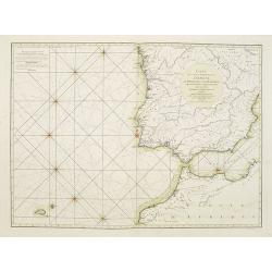
Carte des Côtes occidentales d'Espagne de Portugal et de Barbarie.
Rare French of Spain, Portugal, Gibraltar and part of Morocco. Prepared by Jacques-François L'Abbé Dicquemare (1733-1789). Latitude and longitude scales, compass rose ...
Date: Paris, ca. 1775
Selling price: ????
Please login to see price!
Sold in 2015
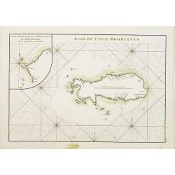
Plan de lIsle de Rodrigues. / Plan particulier du Nord de l'Isle de Madagascar depuis le Cap d' Ambre jusqu'à Infandria. Plan particulier du Nord de l'Isle de Madagascar depuis le Cap d'Ambre jusqu'à Infandria.
French of Isle Rodrigue on East coast of Madagascar. Latitude and longitude scales, compass rose and system of rhumb lines, soundings near coast and in bay areas.D' Apr�...
Date: Paris, Brest, chez Demonville, 1775
Selling price: ????
Please login to see price!
Sold in 2011
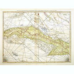
The Island of Cuba with part of the Bahama Banks and the Martyrs. . .
Engraved nautical chart showing tracks, rhumb lines, currents, etc. Relief shown pictorially, depths by soundings. Covers also the southern Florida Keys and Dry Tortugas....
Date: London, Sayer and Bennett, c.1775
Selling price: ????
Please login to see price!
Sold in 2012
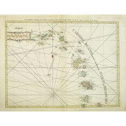
The Caribbee Islands, The Virgin islands, and the Isle of Porto Rico. . .
Engraved nautical chart showing rhumb lines, shoals, anchorages, etc. Relief shown pictorially, depths by soundings. Covers area south to Barbados. The nautical informati...
Date: London, Sayer and Bennett, 1775
Selling price: ????
Please login to see price!
Sold in 2012
The Windward Passage, with the several passages, from the east end of Cuba, and the north part of St. Domingo.
Engraved nautical chart showing tracks, rhumb lines, etc. Covers part of the Bahamas and the Turks and Caicos Islands. A partial compass roses anchor the bottom of the ch...
Date: London, Sayer and Bennett, 1775
Selling price: ????
Please login to see price!
Sold in 2012
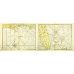
The Coast of West Florida and Louisiana. (together with) The Peninsula and Gulf of Florida or Channel of Bahama with the Bahama Islands.
Two nautical charts showing of the coast of West Florida and Louisiana, together with the Peninsula and Gulf of Florida or Channel of Bahama with the Bahamas Islands. Dep...
Date: London, Sayer and Bennett, 1775
Selling price: ????
Please login to see price!
Sold in 2012
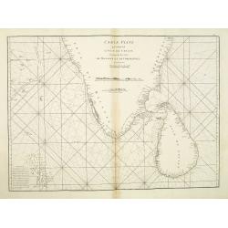
Carte Plate qui comprend L'Isle de Ceylan. . .
Chart showing the southern tip of India and Sri Lanka. Latitude and longitude scales, compass rose and system of rhumb lines, soundings near coast and in bay areas.D' Apr...
Date: Paris, 1775
Selling price: ????
Please login to see price!
Sold in 2021
Plan de la Baye et du Port de Rio-Janeiro.
French of mostly focusing on Guanabara bay. Notice the names of the many now famous areas of Rio are already firmly established (Botafogo, Lame, S. Cristovao, Gloria, et...
Date: Paris, Brest, Demonville, 1775
Selling price: ????
Please login to see price!
Sold in 2021
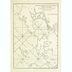
Plan de la baye et Ville de Manille, Capitale des Isles de Philippines . . .
French sea chart of the inlet and city of Manila with latitude and longitude scales, compass rose and system of rhumb lines, soundings near coast and in bay areas.Publish...
Date: Paris, Brest, Demonville, 1775
Selling price: ????
Please login to see price!
Sold in 2012
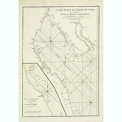
Carte Plate du Golfe de Siam avec une Partie des Cotes de Malaye et de Camboje, depuis l'Isle Timor jusqu'a celle Condor. . .
French sea chart of the Gulf of Siam. The map shows the coast from the Mekong delta to the Isle of Tioman, near the tip of the Malaysian Peninsula. Soundings and rhumblin...
Date: Paris, Brest, Demonville, 1775
Selling price: ????
Please login to see price!
Sold in 2014
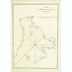
Plan du port de Subec, en l'Isle de Luçon.
French sea chart of Subic Bay and the town of "Subec", prepared in 1766. Subic is a 1st class municipality in the province of Zambales, Philippines. It is found...
Date: Paris, Brest, Demonville, 1775
Selling price: ????
Please login to see price!
Sold in 2012
Carte d'une partie des Côtes de la Chine et des Isles adjacentes depuis l'Isle nommée la Pierre Blanche, jusqu'à celle de l'Artimon.
Most important milestone chart based upon the surveys made from navigational surveys and soundings in 1754, 1759, and 1760 by Alexander Dalrymple. This edition of Dalrymp...
Date: Paris, Brest, Demonville, 1775
Selling price: ????
Please login to see price!
Sold in 2012
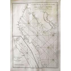
Carte plate du Golfe de Siam, avec une partie des Côtes De Malaye Et De Camboje...
Superb large sea-chart of the Gulf of Siam with coasts of Thailand and Cambodia. Extending from the Mekong delta to Bangkok, and south to the Isle of Tioman. With a large...
Date: Paris, 1775
Selling price: ????
Please login to see price!
Sold in 2012
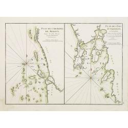
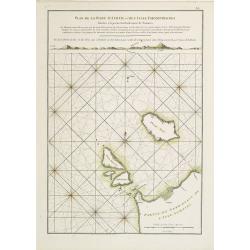
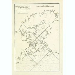
Plan de l'Archipel de Merguy, depuis les Isles Moscos jusqu'à l'Isle Domel. / Plan de l'Isle Junkseilon et de son Port. Situés à la côte de Queda... Plan de la Rivière de Surate.
French of the Archipelago of Merguy and the Island of Junkseilon (Phuket) and its port.Latitude and longitude scales, compass rose and system of rhumb lines, soundings n...
Date: Paris, Brest, chez Demonville, 1775
Selling price: ????
Please login to see price!
Sold in 2012
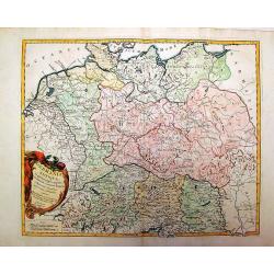
Germania Antiqua in Quator Magnos Populus.
A large, detailed, copper engraved map of antique Germany, Poland, and Low Countries that Vaugondy created. It has a large decorative Rococo cartouche. Francois or Paolo ...
Date: Venice, 1775
Selling price: ????
Please login to see price!
Sold in 2015