Browse Listings
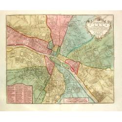
Nieuwe kaart der platte Grond van de Stad Parys en derzelve voorsteden
Izaak Tirion (d. 1769) Amsterdam publisher. His ' Nieuwe en beknopte handatlas' saw 6 editions between before 1740 and after 1784. Also ' Tegenwoordige staat van alle vol...
Date: Amsterdam, c. 1770
Selling price: ????
Please login to see price!
Sold
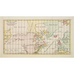
![Untitled [Nordlicher Theil des Grossen Süd Meers].](/uploads/cache/23671-250x250.jpg)
Untitled [Nordlicher Theil des Grossen Süd Meers].
Uncommon map illustrating the Californian and some of the Mexican Pacific shores. With notations in German. In the upper central part some marks are visible due to cracks...
Date: Germany, 1750 - 1770
Selling price: ????
Please login to see price!
Sold
![[2 maps] Carte des Nouvelles découvertes.. / Extrait d'une Carte Japonaise de l'Univers..](/uploads/cache/23658-250x250.jpg)
[2 maps] Carte des Nouvelles découvertes.. / Extrait d'une Carte Japonaise de l'Univers..
Two maps on one sheet. In both maps there are texts a.o. by Kaempfer who refers to voyages made by Japanese seafarers in that region. The map is from Diderot's Encycloped...
Date: Paris, 1770
Selling price: ????
Please login to see price!
Sold
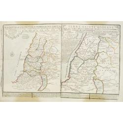
Descriptio Acurata Terrae Promissae Per Sortes XII.. & Terre Sainte Moderne.
2 maps on 1 sheet. To the left a very attractive map of Palestine divided among the 12 Tribes on both sides of the Jordan, after Philippe de La Rue. At the right hand sid...
Date: Paris, 1770
Selling price: ????
Please login to see price!
Sold in 2013
![Untitled [Nordlicher Theil des Grossen Süd Meers].](/uploads/cache/24713-250x250.jpg)
Untitled [Nordlicher Theil des Grossen Süd Meers].
Uncommon map illustrating the Californian and some of the Mexican Pacific shores. With notations in German. In the upper central part some marks are visible due to cracks...
Date: Germany, 1750 - 1770
Selling price: ????
Please login to see price!
Sold
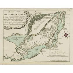
Karte von der Insel Montreal..
A rare issue of a plan of Montreal, published by G.Raspe in \"Schau Plats Des Gegenwaertigen Kriegs ...\". The title, at top left, credits Bellin.
Date: Nürnberg, 1770
Selling price: ????
Please login to see price!
Sold in 2008
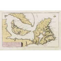
Grund Riss der Americanischen Insuln Cape Breton, St. Iean und Anticosti im Flusse S. Laurencii..
Map representing the eastern part of Nova Scotia, namely Cape Breton and Prince Edward Islands. With an inset map of Anticosti Island on top.
Date: Nurnberg, 1770
Selling price: ????
Please login to see price!
Sold in 2023
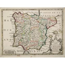
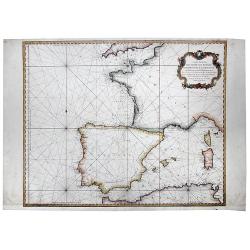
Nouvelle Carte du Royaume d' Espagne.
Attractive small map of the Iberian peninsula.
Date: Paris, c. 1770
Selling price: ????
Please login to see price!
Sold
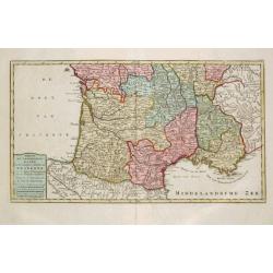
Nieuwe kaart van het Zuidelykste Gedeelte van Frankryk.
Izaak Tirion (d. 1769) Amsterdam publisher. His ' Nieuwe en beknopte handatlas' saw 6 editions between before 1740 and after 1784. Also ' Tegenwoordige staat van alle vol...
Date: Amsterdam, c. 1770
Selling price: ????
Please login to see price!
Sold
Extrémité Méridionale de l'Amerique.
Rigobert Bonne (1727-1795), French cartographer. His maps are found in a.o. Atlas Moderne (1762), Raynal's Histoire Philos. du Commerce des Indes (1774) and Atlas Encyclo...
Date: Paris, c.1770
Selling price: ????
Please login to see price!
Sold in 2008
Manuscript map Novara Piemonte.
Exceptional plan of Novara, dated 1770, link lower corner: 22 remarkable places noted. The author indicated (viator maior Aloysius Ruglerius). Scala di Bracia di Milano g...
Date: Italy, 1770
Selling price: ????
Please login to see price!
Sold in 2018
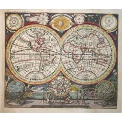
Planisphaerium. Orbis terrarum
Lovely double hemisphere map from Hubner's Lexicon. CALIFORNIA IS AN ISLAND. Diagrams of the Copernican and Ptolemaic solar systems in the corners.
Date: Leipzig, ca.1770
Selling price: ????
Please login to see price!
Sold in 2008
Détroit de Magellan, avec les Plans des principaux ports, Bayes etc. de ce Détroit.
Rigobert Bonne (1727-1795), French cartographer. His maps are found in a.o. Atlas Moderne (1762), Raynal's Histoire Philos. du Commerce des Indes (1774) and Atlas Encyclo...
Date: Paris, c.1770
Selling price: ????
Please login to see price!
Sold
![[Untitled Russan provinces]](/uploads/cache/25959-250x250.jpg)
[Untitled Russan provinces]
Map of Russian provinces. Centered on Moscow. Engraved by Liebaux.
Date: Paris, ca 1770
Selling price: ????
Please login to see price!
Sold in 2010

America Meridionalis Concinnata juxta Observationes Dnn Acad
colored copper engraving showing South America. After a map of De l'Isle.
Date: Augsburg, 1770
Selling price: ????
Please login to see price!
Sold in 2009
Plan von Constantinopel, mit der umliegenden Gegend, und des Canals vom Schwarzen Meer.
Engraved plan of Constantinople and environs with a extensive key to 75 of the most important buildings in town.A decorative handcolored map of Constantinople, Bosporus, ...
Date: Augsburg, 1770
Selling price: ????
Please login to see price!
Sold in 2009
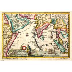
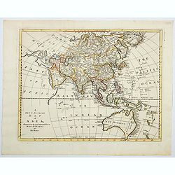
Asia Concinnata Secundum Observationes Academiae Regalis ...
Map of Asia.
Date: Augsburg, c.1770
Selling price: ????
Please login to see price!
Sold in 2009
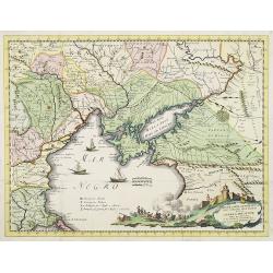
Nuova Carta Geografica per servire alla storia della Guerra Presente tra la Russia, e la Porta Ottomana..
Decorative and rare map of the Black Sea Region and contiguous countries, centered on Crimea.With impressive title cartouche illustrating a siege of a stronghold. &cu...
Date: Venice, 1770
Selling price: ????
Please login to see price!
Sold in 2009
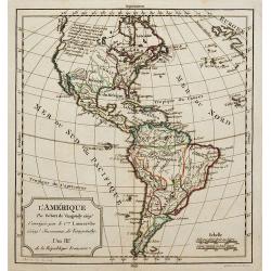
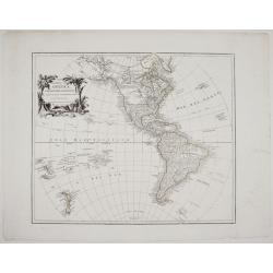
L\'Amérique.
A nice map of America.
Date: Paris, ca.1770
Selling price: ????
Please login to see price!
Sold in 2011

Mausolée.
In the eighteenth and nineteenth centuries there were many popular speciality establishments in Paris, Augsburg and London which produced optical viewing devices and spec...
Date: Augsburg 1770
Selling price: ????
Please login to see price!
Sold in 2010

La ville de Babylone.
In the eighteenth and nineteenth centuries there were many popular speciality establishments in Paris, Augsburg and London which produced optical viewing devices and spec...
Date: Augsburg 1770
Selling price: ????
Please login to see price!
Sold in 2010
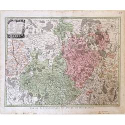
Partie Septentrionale du Duche de Bourgogne.
Map showing the Burgundy region of France. The cities of Auxonne and Dijon are shown in the lower right, Auxerre in the upper left and Chaumont in the upper right.
Date: Augsburg, 1770
Selling price: ????
Please login to see price!
Sold in 2010
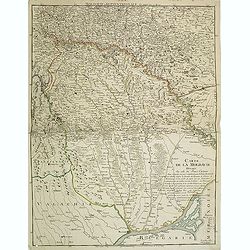
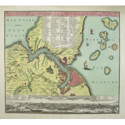
Carte de la Moldavie dressée sur celle du prince Cantimir. . .
Extremely rare map of the north of Moldavia and the regions today in Ukraine. In top the title Moldavie Septentrionale. Another map of the southern part exists to complem...
Date: Paris, 1770
Selling price: ????
Please login to see price!
Sold in 2011
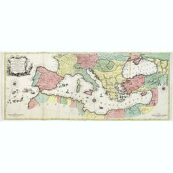
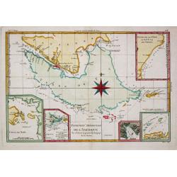
Carte Geographique representant la Mer Mediterranée ou la seconde Partie du Theatre de la Guerre entre les Russes et les Turcs C'est à dire les Roiaumes, les Etâts, les Provinces. . .
A beautiful map of the Mediterranean Sea. Embellished with three compass roses and sailing vessels, including a scene on a naval battle in the Atlantic off of Gibraltar.T...
Date: Augsbourg, 1770
Selling price: ????
Please login to see price!
Sold in 2014
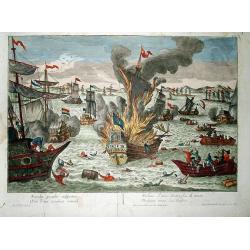
NAVALIS PRAELII ADSPECTUS, VUE D'UN COMBAT NAVAL, VEDUTA D'UNA BATTAGLIADI MARE, PROSPECT EINES SEE-TREFFENS.
Rare print, showing a dramatic sea battle scene with a warship burning, sailors and goods swimming in the water, and rowing rescue boats trying to save them. Numerous oth...
Date: Augsburg, 1770
Selling price: ????
Please login to see price!
Sold in 2012

NAVALIS PRAELII ADSPECTUS, VUE D'UN COMBAT NAVAL, VEDUTA D'UNA BATTAGLIADI MARE, PROSPECT EINES SEE-TREFFENS.
Rare print, showing two fleets during a sea battle. One ship burning, others firing their cannons. In the front surviving sailors swimming in the water, and rowing rescu...
Date: Augsburg, 1770
Selling price: ????
Please login to see price!
Sold in 2012
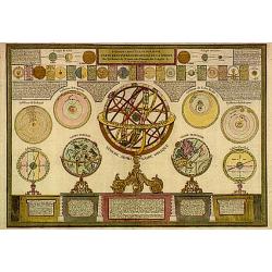
Introduction a la geographie carte des diverses positions..
A charming print showing a terrestrial, celestial and an armillary globe with smaller circular diagrams illustrating the theories of Ptolemy, Copernicus, Brahe and Descar...
Date: Lyon 1771
Selling price: ????
Please login to see price!
Sold
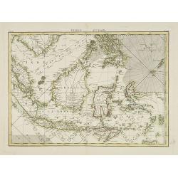
Indes IVe Feulle
A detailed map showing Indonesia, Philippines and New Guinea.
Date: Paris, 1771
Selling price: ????
Please login to see price!
Sold in 2019
Partie de la carte du Captaine Cluny..
From Diderot's Encyclopaedia . Based on Captain Cluny's map of 1769 published in London in American Traveller .
Date: Paris 1771
Selling price: ????
Please login to see price!
Sold
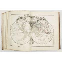
A map of the world from the latest authorities.
Fine double hemisphere world map engraved by Thomas Kitchin.The boundaries of both Australia and New Zealand are not yet completely defined. The northwest coast of North ...
Date: London 1771
Selling price: ????
Please login to see price!
Sold
Asia drawn and engraved from the best maps & chart.
Fine map of the continent of Asia.
Date: London 1771
Selling price: ????
Please login to see price!
Sold
Europa Drawn and Engraved from the best maps and charts.
Fine map of the continent of Europe.
Date: London 1771
Selling price: ????
Please login to see price!
Sold
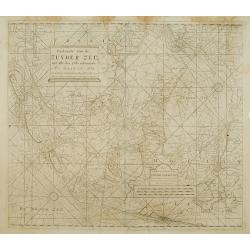
Paskaarte van de Zuyder zee met alle des Zelfs inkoomende Gaaten A° 1771.
Latitude scale, compass rose and system of rhumb lines, soundings, anchorage's, etc. A wealth of cities and information appear in the chart. This is an update of an older...
Date: Amsterdam 1753/1771
Selling price: ????
Please login to see price!
Sold
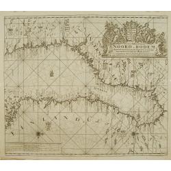
Nieuwe paskaart van de NOORD BODEM.
Latitude scale, compass rose and system of rhumb lines, soundings, anchorage's, etc. A wealth of cities and information appear in the chart. This is an update of an older...
Date: Amsterdam 1771
Selling price: ????
Please login to see price!
Sold
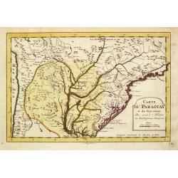
Carte du Paraguay et des Pays voisin.
Jaques Nicolas Bellin (1702-720) was the most important French hydrographer of the 18th century. Sea-atlas 'Hydrographique Français' , 1756-65, atlas to accompany Prévo...
Date: Amsterdam, 1771
Selling price: ????
Please login to see price!
Sold
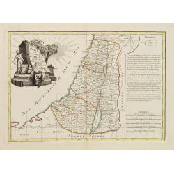
Carte des douze tribus d'Israel..
A finely engraved map depicting the division of the Holy Land into twelve tribes after Bonne.
Date: Paris, 1771
Selling price: ????
Please login to see price!
Sold in 2014
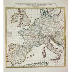
GERMANY, FRANCE ITALY, SPAIN, BRITISH ISLES, In an intermediate Century between Antient and Modern Geography.
Jean Baptist d' Après de Mannevilette (1707-1780), French hydrographer. His sea-atlas of the Asian waters, the ' Neptune Oriental 'was published in 1755.A map of western...
Date: London, R. Sayer and J. Bennett, 1771
Selling price: ????
Please login to see price!
Sold
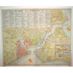
Grundrik Von Constantinopel
An uncommon and superbly engraved plan of Constantinople. There is a charming inset of the Sultan's Palace in the lower right section of the plate. In the upper portion o...
Date: Hamburg, ca. 1771
Selling price: ????
Please login to see price!
Sold
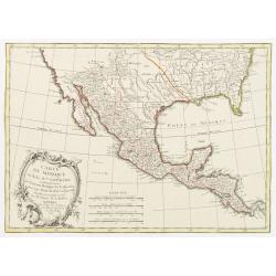
Carte du Mexique ou de la Nlle. Espagne Contenant aussi le Nouveau Mexique, la Californie, avec une Partie des Pays adjacents..
Attractive map covering the region from the Chesapeake Bay through California with Mexico and Central America.Excellent detail, particularly of the Jesuit missions in Mex...
Date: Paris, 1771
Selling price: ????
Please login to see price!
Sold in 2022
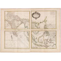
Carte Hydro-geo-graphique des Indes Orientales.. (Set of Four Maps)
A detailed map with a large, and very decorative title cartouche, showing the coast of southern China, Taiwan and the northern Philippines region with particular detail i...
Date: Paris 1771
Selling price: ????
Please login to see price!
Sold in 2014
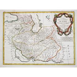
Carte de l\' Empire de Perse.
Jean Lattré, Paris-based engraver and publisher. Worked with Robert de Vaugondy, J. Janvier and R. Bonne. " Atlas Monderne', 1771, 1783 , 1793. Rigobert Bonne, Fren...
Date: Paris, 1771
Selling price: ????
Please login to see price!
Sold in 2010
Atlas moderne ou collection de cartes sur toutes les parties du globe terrestre par plusieurs auteurs.
Typical 18th century French atlas, including maps by Janvier, Rizzi Zannoni and Bonne. Decorative title page of part one: two women holding the title in a large drape, th...
Date: Paris, Lattré, 1771
Selling price: ????
Please login to see price!
Sold
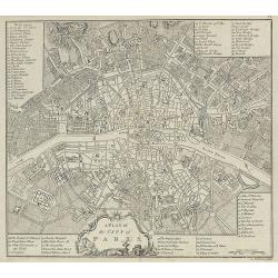
A Plan of the City of Paris.
Nicely detailed 18th century map of Paris, published in A collection of plans of the most capital cities of every empire, kingdom and electorate in Europe and some remark...
Date: London, 1771
Selling price: ????
Please login to see price!
Sold in 2009
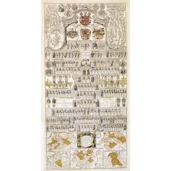
Vorstellung der Sächsischen Historie daraus die ge sämtlichen Regenten.
A decorative plate with hundreds of Kings of Saxony; with in bottom five maps of the region of Saxony during different periods.The map in lower right showing the foundati...
Date: Berlin, 1771
Selling price: ????
Please login to see price!
Sold in 2013
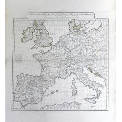
Germanie, France, Italie, Espagne, Isles Britanniques,; Dans un Age intermediaire de l'Anciene Geographie et de la Moderne
A beautiful 18th century map of Europe by Jean Baptiste Bourguignon D'Anville, showing the areas of ancient civilizations of Europe. Areas of ancient civilization shown i...
Date: Paris, 1771
Selling price: ????
Please login to see price!
Sold in 2010
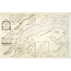
An exact chart of the River St. Laurence, from Fort Frontenac to the Island of Anticosti, shewing the soundings, rocks, shoals &c.
Published in "A General Atlas", with dedication to Jn. Montague, Earl of Sandwich. Dated 1771. This is the fourth state of five. With five insets. A chart of th...
Date: London, Robert Sayer, 1771
Selling price: ????
Please login to see price!
Sold in 2013
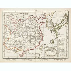
L'Empire de la Chine avec les isles du Japon.
Uncommon map of China, Japan, Korea and Taiwan. In lower right division of Chinese provinces. In bottom 4 scales.
Date: Paris / Bordeaux, 1771
Selling price: ????
Please login to see price!
Sold in 2015

Daniel Rabel Yellow & White Lilly - Pl. XXX.
This engraving was originally published in "Theatrum Florae" in Paris in 1622 as a collection of plates of the most beautiful flowering plants available in earl...
Date: Paris, 1771
Selling price: ????
Please login to see price!
Sold in 2019
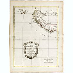
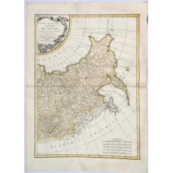
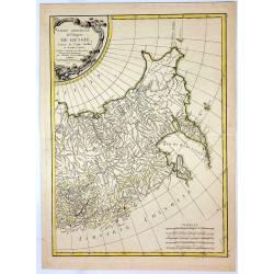
Carte de la Guinee, contenant les Isles du Cap Verd, le Senegal, la Cote de Guinee proprement dite, les Royaumes de Loango, Congo, Angola et Benguela....
A map of the Gulf of Guinea by Jean Lattré, a Paris-based engraver and publisher. He worked with Robert de Vaugondy, J. Janvier and R. Bonne. From his "Atlas Modern...
Date: Paris, 1771
Selling price: ????
Please login to see price!
Sold in 2017
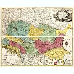
Carte Geographique du Theatre de la Guerre en General representant le Royaume de Hongarie la Principauté de Transylvanie, et les Royaumes de Croacie, de Dalmacie, de Esclavonie, de Bosnie, de Servie . . .
Carte Geographique du Theatre de la Guerre en General representant le Royaume de Hongarie la Principauté de Transylvanie, et les Royaumes de Croacie, de Dalmacie, de Esc...
Date: Augsburg, 1771
Selling price: ????
Please login to see price!
Sold in 2021

Three Copper Engravings by DIDEROT Featuring Asronomical Instruments (Heliometer & Micrometer)
This set of three (3) antique prints originate from: 'The Encyclopédie ou Dictionnaire raisonné des sciences, des arts et des métiers, par une Société de Gens de let...
Date: Paris, 1771
Selling price: ????
Please login to see price!
Sold in 2017

Three Copper Engraved Diderot Astronomical Instruments (Secteur & Heliometer).
This set of three (3) antique prints originate from: 'The Encyclopédie ou Dictionnaire raisonné des sciences, des arts et des métiers, par une Société de Gens de let...
Date: Paris, 1771
Selling price: ????
Please login to see price!
Sold in 2017

Three Copper Engravings by DIDEROT Featuring Astronomical Instruments .
This set of three (3) antique prints originate from: 'The Encyclopédie ou Dictionnaire raisonné des sciences, des arts et des métiers, par une Société de Gens de let...
Date: Paris, 1771
Selling price: ????
Please login to see price!
Sold in 2017

The British Troops entering the Breach of the Moro Castle Engraved for Mountagues History of England.
The scene "CUBA: BATTLE OF HAVANA", British troops entering the breach in the fortress, Morro Castle, during the Battle of Havana, in the July of 1762. Engraved...
Date: London, 1771
Selling price: ????
Please login to see price!
Sold in 2017
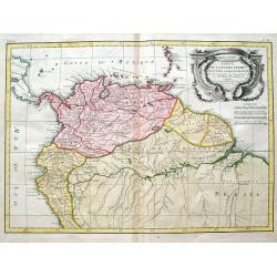
Carte De La Terre Ferme, de la Guyane, et du Pays des Amazones...
Fine map of the northern part of South America, including Aruba, Bonaire, Curacao, Trinidad, Columbia, Peru, Venezuela, Ecuador, Guyana, and the northern part of Brazil. ...
Date: Paris, 1771
Selling price: ????
Please login to see price!
Sold in 2018
Partie Orientale de l 'Empire de Russie. . .
A striking map of western Russia. Includes Tartarian Russia with Siberia and the Bering Strait, and from the Arctic Ocean to the Caspian Sea, Sakhalin and Kamchatka. The ...
Date: Paris, 1771
Selling price: ????
Please login to see price!
Sold in 2021
Partie Orientale de l'Empire de Russie.
A fine map of eastern Russia by Bonne in Paris in 1771. Published by Chez Lattre. This is one of two maps featuring all of Russia. Features decorative title cartouche.Rig...
Date: Paris, 1771
Selling price: ????
Please login to see price!
Sold in 2017
![[4 sheet map] Carte Hydro-geo-graphique des Indes Orientales . . .](/uploads/cache/41388-250x250.jpg)
[4 sheet map] Carte Hydro-geo-graphique des Indes Orientales . . .
A detailed map with a large, decorative title cartouche, showing from India east to the Philippines, Borneo, Java, the Celebes, and Timor and Formosa. Marked across areas...
Date: Paris, 1771
Selling price: ????
Please login to see price!
Sold in 2020
![Turcia Asiatica exhibens Natoliam Modernam [shows Cyprus].](/uploads/cache/83655-250x250.jpg)
Turcia Asiatica exhibens Natoliam Modernam [shows Cyprus].
A beautifully colored, regional map, extending from Cyprus and Greece in the west to the Caspian Sea in the East and centered on Asia Minor, Aremenia, Iraq and Turkey. A ...
Date: Nuremberg, 1771
Selling price: ????
Please login to see price!
Sold in 2020
Carte Reduite Des Costes de France, De Portugal, et D'Espagne sur l'Ocean et sur la Mediterranee. 1771.
A detailed chart of the coastline of south western Europe. Coastal detail only, interiors left blank. Decorative cartouche. Rhumb lines , published by the French Hydrogra...
Date: Paris, 1771
Selling price: ????
Please login to see price!
Sold in 2020
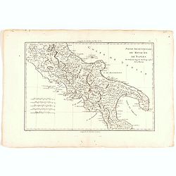
Partie Septentrionale du Royaume de Naples.
Map of the Northern part of the Kingdom of Naples, by Rigobert Bonne.
Date: Paris, 1771
Selling price: ????
Please login to see price!
Sold in 2022
CARTE REDUITE DES ISLES MALOUINES OU .. ISLES DE FALKLAND 1771
Large-scale nautical chart of the Falkland islands with rhumb lines, soundings and anchorages, detailed chart with depth soundings and the tracks of recent French and Eng...
Date: Paris, 1771
Selling price: ????
Please login to see price!
Sold in 2021
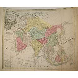
A new & accurate map of Asia, drawn from the most approved Modern Maps & Charts.
An excellent engraving of Asia. The map renders the entire continent in excellent detail with mountains, rivers, lake and forests. The map is of interest for the use of S...
Date: London, ca 1771
Selling price: ????
Please login to see price!
Sold in 2023
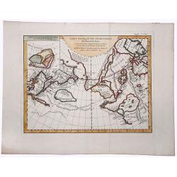
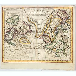
CARTE GENERALE DES DECOUVERTES de l'Amiral de Fonte, et autres navigateurs. . .
An extremely interesting map of the Northwest Coast, showing De L'Isle's conjectural northwest coast, based upon De Font and Russian Discoverers, including the Bay of the...
Date: Paris, 1772
Selling price: ????
Please login to see price!
Sold in 2019
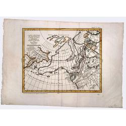
CARTE GENERALE DES DECOUVERTES de l'Amiral de Fonte,representant la grande possibilite d'un PASSAGE AU NORD OUEST.
A fascinating map of the Northwestern part of America, illustrating the reports of De L'Isle of the Russian discoveries in the region prior to 1750, which he obtained dur...
Date: Paris, 1772
Selling price: ????
Please login to see price!
Sold in 2019
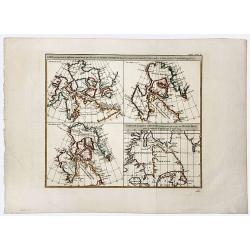
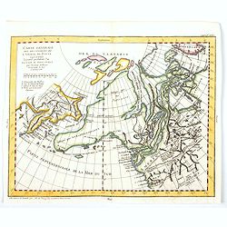
Carte qui represente les differentes connoissances que L'on a eues des Terres Arctiques depuis 1650. . . CARTE DE LA BAYE D' HUDSON.
A beautiful set of four maps of the Hudson, Button and Baffin Bay regions, Davis Straits and the Coast Labrador, showing the evolution of cartography and discoveries of t...
Date: Paris, 1772
Selling price: ????
Please login to see price!
Sold in 2019
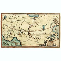
Carte du Chemin d'Amour.
Among the allegorical maps of early modern times, those relating to romantic attachments, sexual relationships and marriage have long excited curiosity among students of ...
Date: France, ca. 1772
Selling price: ????
Please login to see price!
Sold in 2021
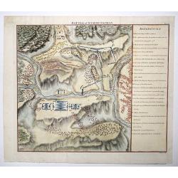
Battle of Stavoutschan.
A beautiful map showing the Battle of Stavutschan during the Russian-Austrian Turkish War (1736-39). Engraved by J. Mynde. From Manstein, Chr. H. v.', "Mémoires his...
Date: London, 1772
Selling price: ????
Please login to see price!
Sold in 2020
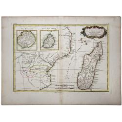
Partie de la Cote Orientale d'Afrique.
A striking 18th Century map of the east coast of Africa, Madagascar, Mauritius and Reunion Island. The map is divided into kingdoms and shows nice detail. Rigobert Bonne ...
Date: Paris, 1772
Selling price: ????
Please login to see price!
Sold in 2020
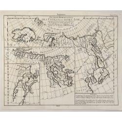
Nouvelle Representation des Cotes Nord et Est de l'Asia.
A map of the north and east coast of Asia, showing an oddly shaped Japan and inset maps of Kamchatka. It originates from: 'The Encyclopédie ou Dictionnaire Raisonné des...
Date: Paris, 1772
Selling price: ????
Please login to see price!
Sold in 2023

Decorative pilaster with fruit, flowers, mythological figures and endrils.
A very fine, and an extremely decorative image from the work entitled "Loggie di Rafaele nel Vaticano" depicting the decorative work executed by Raphael and hi...
Date: Rome, 1772
Selling price: ????
Please login to see price!
Sold in 2020
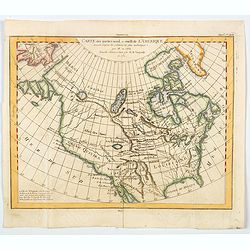
Carte des parties nord et ouest de L' Amerique. . .
An interesting map of North America, based upon an earlier map by Thomas Engel. His map of North America was issued in his 'Memoires Observations Geographique' in 1765, a...
Date: Paris, 1772
Selling price: ????
Please login to see price!
Sold in 2020
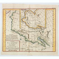
Carte de la Californie et des Pays Nord Ouest separes de L'Asie par le Detriot d'Anian. . .
Two map shown. The larger map prominently shows the Strait of Anian, Anian Regnum, Quivira Regnum, the Sierra Nevada, Nova Albion, Tontonteac Regnum, Tolm Regnum and a co...
Date: Paris, 1772
Selling price: ????
Please login to see price!
Sold in 2020
Carte generale des Decouvertes de L'Amiral de Fonte. . .
An interesting map of the northwest coast, showing de L'Isle's conjectural northwest coast, based upon that of de Font and Russian Discoverers, including the Bay of the W...
Date: Paris, 1772
Selling price: ????
Please login to see price!
Sold in 2020
Mapa general de América ó hemisferio occidental. . .
A rare and very detailed map of Americas and the Western Hemisphere. With a decorative cartouche flanked by two trees, an exotic bird and a crocodile.
Date: Madrid, 1772
Selling price: ????
Please login to see price!
Sold in 2020
General Map of the Discoveries of Admiral de Fonte representing the great probability of a Passage to the North West by Thomas Jefferys. . .
An attractive and interesting map issued in the supplement to Diderot's 'Encyclopedie' as part of the series of ten maps by de Vaugondy illustrating the then-current view...
Date: Paris, 1772
Selling price: ????
Please login to see price!
Sold in 2020
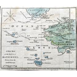
A New Map of the Land of Matrimony, drawn from the latest Surveys.
A very rare satirical map of the Ocean of Love, filled with humorous place names such as Brides Bay, Divorce Island, Rocks of Jealousy,...). The compass rose shows indiff...
Date: London, 1772
Selling price: ????
Please login to see price!
Sold in 2021
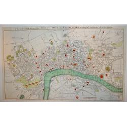
A New and Accurate Plan of the Cities of London and Westminster, including the New Roads & Buildings.
A large, attractive and nicely detailed plan of London as seen in the early 1770?s. A scarce piece.John Andrews produced only a small number of works and is primarily rec...
Date: London, c. 1772
Selling price: ????
Please login to see price!
Sold
Partie de la carte du Capitaine Cluny? publié en 1769.
A map of North America with a supposedly northwest passage.
Date: Paris, 1772
Selling price: ????
Please login to see price!
Sold
Mappa geographiaca .. regnum Poloniae et .. Lithuaniae ..
Uncommon map of Poland. T.C. Lotter married M. Seutter's daughter in 1740 and succeeded him in 1756. Lotter used the copperplate of Seutter, he only changed the name.
Date: Augsbourg, 1772
Selling price: ????
Please login to see price!
Sold