Browse Listings in Australia & Oceania
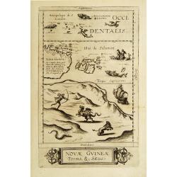
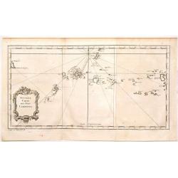
Novae Guineae Forma & Situs.
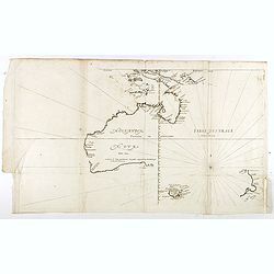
Extraordinarily rare map of the eastern part of Australia. The first separate map of this continent ever printed.The map appeared in the 2nd edition of De Jode's rare Spe...
Date: Antwerp 1593
Selling price: ????
Please login to see price!
Sold
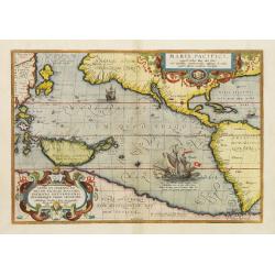
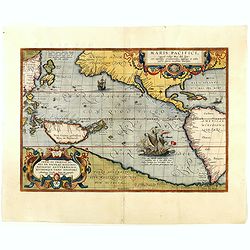
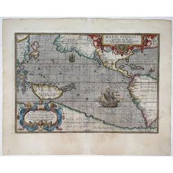
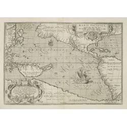
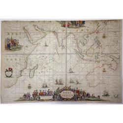
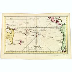
Maris Pacifici.
This was the first printed map to be devoted solely to the Pacific, and the first to name North and South America separately. Lower right a large presentation of Ferdinan...
Date: Antwerp, 1595
Selling price: ????
Please login to see price!
Sold in 2016
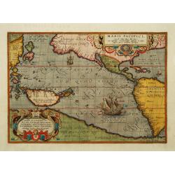
Maris Pacifici.
This was the first printed map to be devoted solely to the Pacific, and the first to name North and South America separately. It includes most of North and South America,...
Date: Antwerp 1595
Selling price: ????
Please login to see price!
Sold
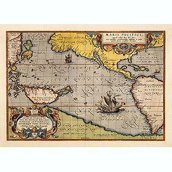
Maris Pacifici.
This was the first printed map to be devoted solely to the Pacific, and the first to name North and South America separately. It includes most of North and South America,...
Date: Antwerp, 1595
Selling price: ????
Please login to see price!
Sold in 2012
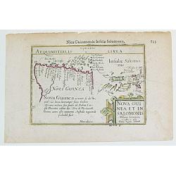
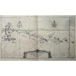
Nova Guinea et In. Salomonis.
From the CAERT-THRESOOR, one the very first maps to depict New Guinea as a separate island. This work is also the first to provide a "full" charting / identific...
Date: Paris, 1598
Selling price: ????
Please login to see price!
Sold
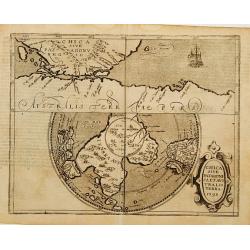
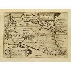
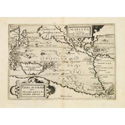
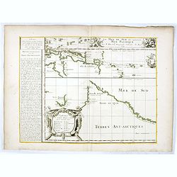
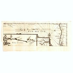
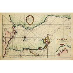
Chica sive Patagonica et Australis Terra 1598.
Very rare sixteenth century map: A reduced version of the Cornelis Wytfliet map of the same name.The map is divided into two sections. The top half is drawn on normal pro...
Date: Cologne 1598
Selling price: ????
Please login to see price!
Sold
Maris Pacifici vulgo Mar del Zur.
The second printed map devoted to the Pacific.Published in the German edition of José de Acosta's De Natura Nova Orbis. All other maps in the book are reduced versions o...
Date: Cologne 1598
Selling price: ????
Please login to see price!
Sold

Maris Pacifici.
From the rare Dutch text edition of the Theatrum of which according to van den Broecke only 100 copies are printed.This was the first printed map to be devoted solely to ...
Date: Antwerp, 1598
Selling price: ????
Please login to see price!
Sold in 2025
Maris Pacifici.
This was the first printed map to be devoted solely to the Pacific, and the first to name North and South America separately. Lower right a large presentation of Ferdinan...
Date: Antwerp, 1598
Selling price: ????
Please login to see price!
Sold in 2018
Maris Pacifici vulgo Mar del Zur.
Only the second printed map devoted to the Pacific. Reduced version of the map by Ortelius, it lacks latitude and longitude markings.Published in Metellus America sive No...
Date: Cologne c. 1602
Selling price: ????
Please login to see price!
Sold
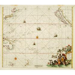
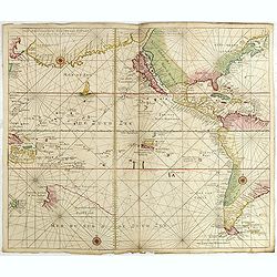
Maris Pacifici, (quod vulgo Mar del Zur) ...
The first printed map of the Pacific Ocean. Date on the map: 1589, first published 1590. Based on Mercator's world map of 1569. This was the first map to focus on the Pac...
Date: Antwerp, 1589 / 1603
Selling price: ????
Please login to see price!
Sold in 2022
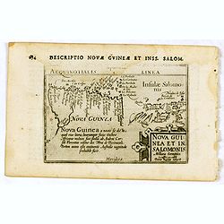
Nova Guinea et In. Salomonis.
Early miniature map of New Guinea from the Caert-Thresoor and engraved by the Dutch master-engraver Petrus Kaerius. The first edition was printed in Middelburg by Barent ...
Date: Amsterdam, Cornelis Claes, 1606
Selling price: ????
Please login to see price!
Sold in 2020
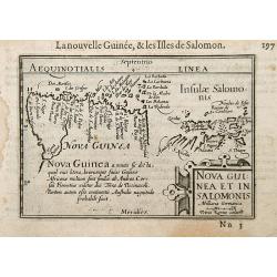
Nova Guinea et In. Salomonis.
Early nice map of New Guinea. The Solomon Islands appear on the right hand portion of the plate. Title cartouche on the lower right corner.First published in 1598 in his ...
Date: Amsterdam / Frankfurt 1609
Selling price: ????
Please login to see price!
Sold
Maris Pacifici.
This was the first printed map to be devoted solely to the Pacific, and the first to name North and South America separately. It includes most of North and South America,...
Date: Antwerp, 1590-1612
Selling price: ????
Please login to see price!
Sold in 2010
Beschreibung Novae Guineae, wie die von Wilhelm Schouten umbfahren.
Rare and very early map of New Guinea, published in Frankfurt in 1619, as part of Hulsius' Sechtzehende Schiffahrt, which retold the voyage of Willem Schouten. Schouten ...
Date: Frankfurt, 1619
Selling price: ????
Please login to see price!
Sold in 2009
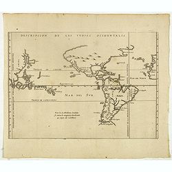
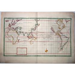
Descripcion de las Yndias Ocidentalis.
Rare early general map of America, the Pacific Ocean and the Eastern part of Asia. Showing "Meridiano de la demarcacion porla parte oscidental" - and "... ...
Date: Amsterdam, Michel Colin, 1622
Selling price: ????
Please login to see price!
Sold in 2025
![[Cavendish meets the natives at Guam.]](/uploads/cache/40369-250x250.jpg)
[Cavendish meets the natives at Guam.]
During Thomas Cavendish’s voyage to the Spice Islands of the East, he dropped anchor in 1587 at Guam in the Ladrones, known as the Islands of Thieves. At least sixty ca...
Date: Frankfurt, M.Merian, 1633
Selling price: ????
Please login to see price!
Sold in 2017
![[What the Dutch experienced at the Ladrones Islands.]](/uploads/cache/40370-250x250.jpg)
[What the Dutch experienced at the Ladrones Islands.]
At the Marianas Islands, the Dutch ship was visited by about 200 small boats, each containing 2 or 3 people. To do trade with them, the Dutch let down ironware by means o...
Date: Frankfurt, M.Merian, 1633
Selling price: ????
Please login to see price!
Sold in 2017
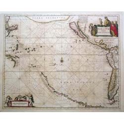
Mar Del Zur Hispanis Mare Pacificum.
Jansson's fine map of the Pacific including the west coast of America, Japan and a small Australian coastline. This is one of the earliest maps of the Pacific. The first ...
Date: Amsterdam, c.1650
Selling price: ????
Please login to see price!
Sold in 2015
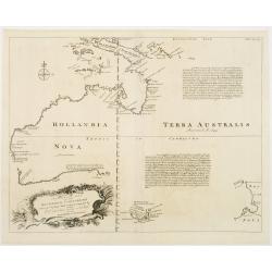
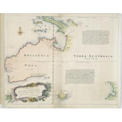
Hollandia Nova detecta 1644 , Terre Australe decouuerte l'an 1644.
Thevenot's map of Australia is the first published large-scale map of Australia and the first French map to record Tasman's 1642-1642 and 1644 discoveries in both Austral...
Date: Paris, Langlois, 1663
Selling price: ????
Please login to see price!
Sold in 2018
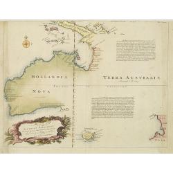
![[No title] Hollandia Nova detecta 1644.](/uploads/cache/36150-250x250.jpg)
[No title] Hollandia Nova detecta 1644.
EXTREMELY RARE FIRST EDITION of Thevenot's map of Australia which is the first published large-scale map of Australia and the first French map to record Tasman's 1642-42 ...
Date: Paris, 1664
Selling price: ????
Please login to see price!
Sold in 2015
La Mer de Sud dite autrement Mer Pacific Par P. Du-val. . .
Lower left sheet of a 4 sheet map of the Pacific. This sheet showing part of the South Sea with Nova Guinea, Carpentaria, Van Diemen's Land, New Zealand and "Terres ...
Date: Paris, 1679
Selling price: ????
Please login to see price!
Sold in 2016
Magnum Mare del Zur.
Based on Goos' 1666 map, California depicted with an indented northern coastline following the second Sanson model. Tasmania, NW Australia and Carpentaria appear, as does...
Date: Amsterdam 1680
Selling price: ????
Please login to see price!
Sold
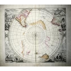
Polus Antarcticus (rare IV State).
A nice example of the rare De Wit edition of the famous, large hemispherical map of the Antarctic region, originally published by Hondius. In this edition the discoveries...
Date: Amsterdam, 1680
Selling price: ????
Please login to see price!
Sold in 2020
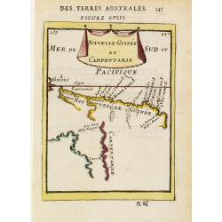
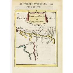
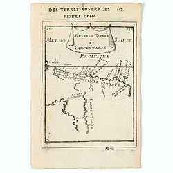
Nouvelle Guinée et Carpentarie.
A charming late 17th century French map of the coast of Australia round Carpentaria Bay and New Guinea. Title displayed on a draped cloth above.
Date: Paris 1683
Selling price: ????
Please login to see price!
Sold
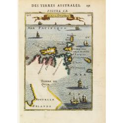
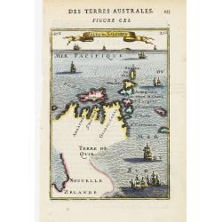
Isles de Salomon.
A curious map reflecting the contemporary ambiguity of the Solomon Islands, and the question as to whether they, and/or New Zealand, is part of a southern continent.The r...
Date: Paris 1683
Selling price: ????
Please login to see price!
Sold
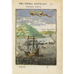
I. Cocos.
A fine view of this Indian Ocean island, with a tall mast ship off the coast.From the French text edition of Description d'Univers, 1683. by Allain Manneson Mallet (1630-...
Date: Paris 1683
Selling price: ????
Please login to see price!
Sold
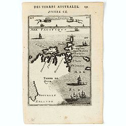
Nouvelle Guinée et Carpentarie.
A charming late 17th century French map of the coast of Australia round Carpentaria Bay and New Guinea. Title displayed on a draped cloth above.
Date: Paris, 1683
Selling price: ????
Please login to see price!
Sold
Isles de Salomon.
A curious map reflecting the contemporary ambiguity of the Solomon Islands, and the question as to whether they, and/or New Zealand, is part of a southern continent.The r...
Date: Paris, 1683
Selling price: ????
Please login to see price!
Sold
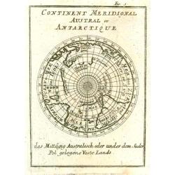
Continent Meridional Austral ou Antarctique.
Interesting map of the South Polar Regions.
Date: Paris, 1683
Selling price: ????
Please login to see price!
Sold in 2010
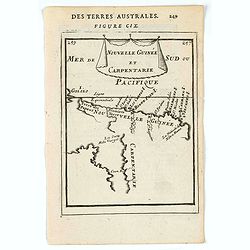
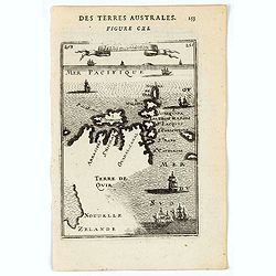
Nouvelle Guinée et Carpentarie.
A charming map of part of Papua New Guinea and the Gulf of Carpentaria in Australia. Title in curtain draped at top. French text on verso.From the original 1683 text edit...
Date: Paris, 1683
Selling price: ????
Please login to see price!
Sold in 2022
Nouvelle Guinée et Carpentarie.
A charming map of New Guinea and Carpentaria. Title in curtain draped at top. French text on verso.From the original 1683 text edition of "Description d'Univers. . ...
Date: Paris, 1683
Selling price: ????
Please login to see price!
Sold in 2020
Isles de Salomon.
A charming map of Salomon Isles. Title in curtain draped at top. French text on verso.From the original 1683 text edition of "Description d'Univers. . ." by All...
Date: Paris, 1683
Selling price: ????
Please login to see price!
Sold in 2020
Isles de Salomon.
A charming map of Salomon Isles. Title in curtain draped at top. French text on verso.From the original 1683 text edition of "Description d'Univers. . ." by All...
Date: Paris, 1683
Selling price: ????
Please login to see price!
Sold in 2020
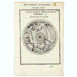
Continent Meridional Austral ou Antartique.
A charming map of Antarctica, showing Austalia, part of Van Diemans Land and a coast of New Zealand.Title in curtain draped at top. French text on verso.From the original...
Date: Paris, 1683
Selling price: ????
Please login to see price!
Sold in 2020
Mar Del Zur Hispanis Mare Pacificum.
Jansson's map of the Pacific, the first of the whole Pacific Ocean, the first chart of the Pacific to show California as an island as well as an imaginary string of islan...
Date: Amsterdam, c.1688
Selling price: ????
Please login to see price!
Sold in 2014
OOST INDIEN Wassende-Graade Paskaart, vertoonende nevens het Oosterlykste van Afrika, meede de Zeekusten van Asia, van C. de Bona Esperance tot Eso, boven Japan. . .
Sea chart of the East Indies on Mercator projection delineating not only the eastern coast of Africa, but also the coasts of Asia, from the C. of Good Hope till Eso, nort...
Date: Amsterdam, ca. 1690
Selling price: ????
Please login to see price!
Sold in 2015
![Globe gore [ Het Niew Hollandt..] (New Holland)](/uploads/cache/31208-250x250.jpg)
Globe gore [ Het Niew Hollandt..] (New Holland)
A globe gore including the Spice Islands, Papua New Guinea and the North Coast of Australia and an explanatory of "Lochac". Italian text below the map which is ...
Date: Venice, 1696
Selling price: ????
Please login to see price!
Sold in 2011
![[Asia]](/uploads/cache/91287-250x250.jpg)
[Asia]
Important Asia map of V.M. Coronelli showing SE Asia with Japan and parts of Australia and New Zealand. Many discoveries around Australia are described with dates, place ...
Date: Venice, 1697
Selling price: ????
Please login to see price!
Sold in 2009
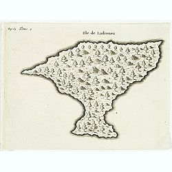
Isle de Ladrones.
Early map of the Mariana Islands (up to the early 20th century sometimes called Ladrones Islands, from Spanish Islas de los Ladrones meaning "Islands of Thieves"...
Date: Amsterdam, E. Roger, 1702
Selling price: ????
Please login to see price!
Sold in 2013
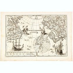
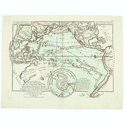
Tantum distamus ap invicem.
A map from the series of maps by the Jesuit mathematician. The map is centered on the Pacific Ocean between Asia and North America. It is an illustration of an uncommon p...
Date: Munich, 1703
Selling price: ????
Please login to see price!
Sold in 2014
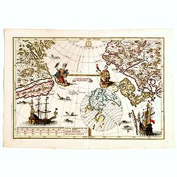
Tantum distamus ap invicem.
A map from the series of maps by the Jesuit mathematician. The map is centered on the Pacific Ocean between Asia and North America. It is an illustration of an uncommon p...
Date: Munich, 1703
Selling price: ????
Please login to see price!
Sold in 2018
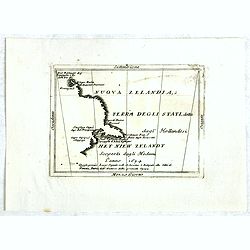
Nouva Zelanda, ò Terra Degli Stati, detta dagl'Hollandesi Het Niew Zelandt. scoperta dagli medemi l'anno 1654 . . .
RARE. This is the first printed map to dedicate to New Zealand, although the information dates back to Tasman in 1642. Showing from the Island of Three Kings to Cape Clip...
Date: Naples, 1706
Selling price: ????
Please login to see price!
Sold in 2016
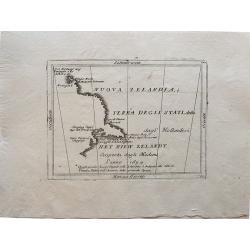
Nuova Zelandia, ò Terra Degli Stati, detta dagl'Hollandesi Het Niew Zelandt. scoperta dagli medemi l'anno 1654 . . .
Rare small map titled 'Nouva Zelanda, ò Terra Degli Stati, detta dagl'Hollandesi Het Niew Zelandt. scoperta dagli medemi l'anno 1654'. Earliest printed copper engraving ...
Date: Venice, 1706
Selling price: ????
Please login to see price!
Sold in 2019
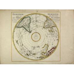
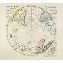
Hemisphere Meridional pour voir plus distinctement les Terres Australes
First edition of the important map of the southern hemisphere by de l'Isle in early strong colors, first published in 1714. This early map of the South Polar regions beca...
Date: Paris, 1714
Selling price: ????
Please login to see price!
Sold in 2013
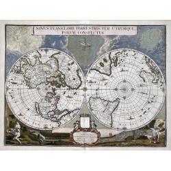
Novus Planiglobii Terrestris per Utrumque polum conspectus.
In the last years of his life, Joan Blaeu commissioned a double hemisphere world map, based on the unusual polar projection. Probably, the terrible fire of February 22, 1...
Date: Amsterdam, 1720
Selling price: ????
Please login to see price!
Sold in 2023
Mar del Zur / Nova Guinea / Terra del Fuogo.
Uncommon map depicting the west coast of South America (with inset map of Tierra del Fuogo) on the extreme right of the map, to Nova Guinea to the left. From the French r...
Date: Amsterdam, F. Bernard, 1725
Selling price: ????
Please login to see price!
Sold in 2018
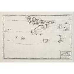
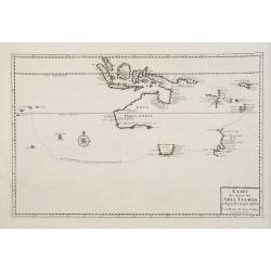
Kaart der Reyse van Abel Tasman volgens syn eygen opstel..
Rare and important map from Vol III, 2 of Valentyn's Oud en Nieuw Oost Indien [1726] detailing the discoveries of Abel Tasman in Australasia during the course of his two ...
Date: Amsterdam 1726
Selling price: ????
Please login to see price!
Sold
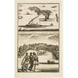
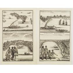
ANAMOCKA By ons genaent 'T EYLANT ROTTERDAM.
2 views on the Salomon Islands on one plate. The scenes illustrate indigenous people on the foreground while the European are represented on the background, discharging b...
Date: Amsterdam 1726
Selling price: ????
Please login to see price!
Sold
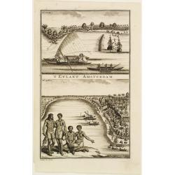
'T EYLANT AMSTERDAM.
2 views on the Salomon Islands on one plate. The scenes illustrate indigenous people on the foreground while the European are represented on the background, discharging b...
Date: Amsterdam 1726
Selling price: ????
Please login to see price!
Sold
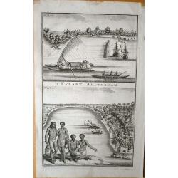
1)'T Eylant Amsterdam. 2) Anamocka.. 't Eylant Rotterdam.
2 sheets featuring 2 views on the Salomon Islands on one plate. The scenes illustrate indigenous people on the foreground while the European are represented on the backgr...
Date: Amsterdam, 1726
Selling price: ????
Please login to see price!
Sold in 2008
\'T Eylant Amsterdam (Solomon Islands).
Engravings showing the native boats and peoples of Amsterdam Island, probably today one of the Solomon's Islands near Indonesia. François Valentijn (1666-1727), a missio...
Date: Dordrecht, 1726
Selling price: ????
Please login to see price!
Sold in 2008
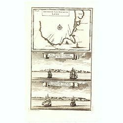
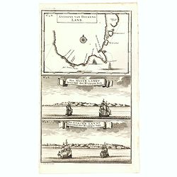
Anthony van Diemens Land / Het vaste Landt bezuyden den Klippigen hoek. / Het Staten Landt bezuyden den Klippigen hoek.
In the upper part, an early map of Tasmania (125x173mm.) shows the track of Abel Tasman's epic first voyage of 1642-1643, which resulted in the discovery of Tasmania and ...
Date: Amsterdam, 1726
Selling price: ????
Please login to see price!
Sold in 2015
Anthony van Diemens Land / Het vaste Landt bezuyden den Klippigen hoek. / Het Staten Landt bezuyden den Klippigen hoek.
In the upper part, an early map of Tasmania (125x173mm.) shows the track of Abel Tasman's epic first voyage of 1642-1643, which resulted in the discovery of Tasmania and ...
Date: Amsterdam, 1726
Selling price: ????
Please login to see price!
Sold in 2016
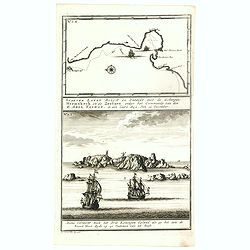
Staeten Landt Bezylt en Ontdekt met de Scheepen Heemskerk en de Zeehaen onder het Commande van den E. Abel Tasman. In den Iaare 1642. Den 13 December.
In the upper part an early map of Staten Landt depicting Tasman's voyage down the west coast of New Zealand in his ships Heemskerk and Zeehaen. The coast line in the Cook...
Date: Amsterdam, 1726
Selling price: ????
Please login to see price!
Sold in 2016
Hemisphere meridional pour voir plus distinctement les terres australes. . .
With the imprint of the Ottens family - rare. An Antarctic map including a recounting of the discovery of an island south of the Cape of Good Hope which was named Cap de ...
Date: Amsterdam, 1740
Selling price: ????
Please login to see price!
Sold in 2011
A Complete Map of the Southern Continent Survey'd by Capt. Abel Tasman & depicted by Order of the East Indian Cmpany in Holland In The Stadt House at Amsterdam.
The first large-scale English map devoted to Tasman's discoveries on both his voyages. Noted on the map are the promises of riches that are certain to be discovered by vi...
Date: London, 1744
Selling price: ????
Please login to see price!
Sold
A Complete Map of the Southern Continent Survey'd by Capt. Abel Tasman & depicted by Order of the East Indian Company in Holland In The Stadt House at Amsterdam.
The first large-scale English map, one devoted to Tasman's discoveries on both his voyages. Noted on the map are the promises of riches that are certain to be discovered ...
Date: London, 1744
Selling price: ????
Please login to see price!
Sold in 2009
A Complete Map of the Southern Continent Survey'd by Capt. Abel Tasman & depicted by Order of the East Indian Cmpany in Holland In The Stadt House at Amsterdam.
The first large-scale English map devoted to Tasman's discoveries on both his voyages. Noted on the map are the promises of riches that are certain to be discovered by vi...
Date: London, 1744
Selling price: ????
Please login to see price!
Sold in 2010
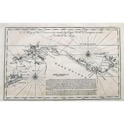
A Map of the Discoveries made by Captain William Dampier in the Roebuck in 1699.
The map shows the route of William Dampier around Timor until New Guinea, around New Britain and back along the coasts of New Guinea.Published in John Harris important wo...
Date: London, 1744
Selling price: ????
Please login to see price!
Sold in 2017
Carte physique de la Grande Mer ci-devant nommée Mer du Sud du Pacifique, qui traverse les parties le splus orientales de l'Asie . . .
General map of the Pacific ocean. Published in Buache's "Considérations géographiques et physiques", one of his most important and original cartographic works...
Date: Paris, 1746
Selling price: ????
Please login to see price!
Sold in 2020
Nouvelle Carte de la Mer Pacifique.
A map in two parts depicting the west coast of South America. Curious is a second coast line of the Chilian coast delineated between 45o S and 50o S in a southwestern dir...
Date: Paris, c. 1750
Selling price: ????
Please login to see price!
Sold
Voyage around World by Anson. -CARTE dans lequelleon voit la route que le Centurion a tenu. . .
A map of Anson's voyage around the world from the French edition of the voyage published in 1750. It was engraved by Lattre and is identical to the English edition "...
Date: Paris, 1750
Selling price: ????
Please login to see price!
Sold in 2021
(Chart of the Pacific Ocean with California as an island)
A rare chart of the Pacific with California with an indented northern coast and the Strait of Anian to the north. There are lots of place names along the coasts of North ...
Date: Amsterdam, 1738 - 1751
Selling price: ????
Please login to see price!
Sold in 2015
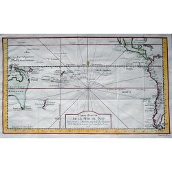
Carte réduite de la Mer du Sud...
Superb map of the South Pacific. The eastern Australia coastline is shown with an imaginary dotted line connecting both Tasmania and New Guinea. New Zealand is shown with...
Date: Paris, 1753
Selling price: ????
Please login to see price!
Sold in 2013
Nouvelle Carte des Isles Carolines.
Antique map of the Caroline Islands, north east of New Guinea and east of the Philipines. Adored with a nice floral, title cartouche. Jacques Nicolas Bellin (1703 – 177...
Date: Paris, 1753
Selling price: ????
Please login to see price!
Sold in 2015
Carte Reduite de la Mer du Sud.
A nice map of the Pacific region as published by Bellin in Paris in the middle of the 18th century. It shows the eastern Australian coast 'as one', with Tasmania and Papu...
Date: Paris, 1753
Selling price: ????
Please login to see price!
Sold in 2019
Carte réduite des Terres Australes..
A nice and decorative map of Australia. Van Diemenland still joined to the main island, prepared by J.N.Bellin. Title cartouche with French text. Underneath the map a tit...
Date: Amsterdam 1758
Selling price: ????
Please login to see price!
Sold
Nouvelle Carte des Isles Carolines.
Jaques Nicolas Bellin (1702-720) was the most important French hydrographer of the 18th century. Sea-atlas 'Hydrographique Français' , 1756-65, atlas to accompany Prévo...
Date: Amsterdam, c. 1760
Selling price: ????
Please login to see price!
Sold in 2008
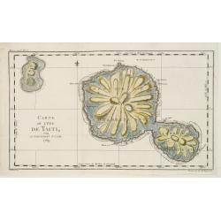
Carte de L'Isle de Taiti par Le Lieutenant J.Cook.
This copper engraved map of the islands of Tahiti is one of the earliest charts of the island. Fully engraved to show its unique mountainous topography and rivers radiati...
Date: Paris 1769
Selling price: ????
Please login to see price!
Sold
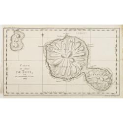
Carte de L'Isle de Taiti par Le Lieutenant J.Cook.
A good engraved map of the island Tahiti, one of the earliest charts of the island. Fully engraved to show its unique mountainous topography and rivers radiating from the...
Date: Paris, 1769
Selling price: ????
Please login to see price!
Sold in 2012
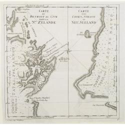
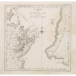
Carte du detroit de Cook dans la Nle. Zelande. Carte von Cook's-Strasse in Neu-Seeland
Showing Cook Strait in New Zealand. Engraved by D.A.Hauer.
Date: Nuremberg, 1773
Selling price: ????
Please login to see price!
Sold
![Instruments des Insulaires de la Mer du Sud. [Tome II Pl. 14.]](/uploads/cache/26103-250x250.jpg)
Instruments des Insulaires de la Mer du Sud. [Tome II Pl. 14.]
Various tools. From the French edition of James Cook's first voyage entitled Relation des voyages entrepris par ordre de sa Majesté Britannique actuellement régnante po...
Date: Paris, 1773
Selling price: ????
Please login to see price!
Sold in 2021
![Vue de l'intérieur d'une maison dans l'Isle d'Ulietéa. Representation d'une danse à la mode du pays. [Tome III Pl. 6.]](/uploads/cache/26114-250x250.jpg)
Vue de l'intérieur d'une maison dans l'Isle d'Ulietéa. Representation d'une danse à la mode du pays. [Tome III Pl. 6.]
Folkloric dance performance in a typical Ulietea house in French Polynesia. Engraved by Patas. From the French edition of James Cook's first voyage entitled Relation des ...
Date: Paris, 1773
Selling price: ????
Please login to see price!
Sold in 2008
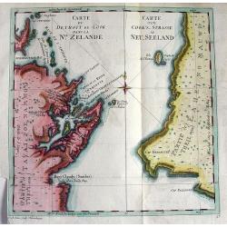
Carte du detroit de Cook dans La Nle. Zelande.
Very important map showing Cook's Strait, which separates the North and South islands of New Zealand. Present day Wellington, Marlborough Sounds, and Cloudy Bay are depic...
Date: Nuremberg, c1773
Selling price: ????
Please login to see price!
Sold in 2010
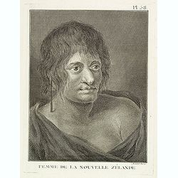
Femme de la Nouvelle Zélande. Pl. 58.
Portrait of a woman from New Zealand. From the French edition of James Cook's first voyage entitled Relation des voyages entrepris par ordre de sa Majesté Britannique ac...
Date: Paris, 1773
Selling price: ????
Please login to see price!
Sold in 2023
![Vue de la Riviere d'Endeavour sur la Cote de la Nouvelle Hollande ou le Vaisseau fut mis a la bande. [Tome IV Pl. 1ere.]](/uploads/cache/45540-250x250.jpg)
Vue de la Riviere d'Endeavour sur la Cote de la Nouvelle Hollande ou le Vaisseau fut mis a la bande. [Tome IV Pl. 1ere.]
The first known landscape drawing of the east coast of Australia. A View of the Endeavour River, on the coast of New Holland, where the ship was laid on shore, in order t...
Date: Paris, 1773
Selling price: ????
Please login to see price!
Sold in 2021
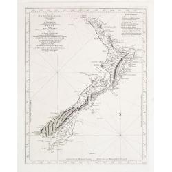
Carte de la Nouvelle-Zelande visitée en 1769 et 1770 par le Lieutenant J. Cook..
Map of New Zealand, engraved by Bernard. The Dutchman Abel Tasman discovered New Zealand in 1642: however it was Cook's circumnavigation of the Islands in 1769 & 1770...
Date: 1774
Selling price: ????
Please login to see price!
Sold
Carte du Detroit de Cook dans la Nle. Zelande. Tome III Pl. 11.
The map depicts Cook\'s Strait, that separates the north and south island of New Zealand. Present day Wellington (NZ\'s capital), Marlborough Sounds, and Cloudy Bay (famo...
Date: Paris, 1774
Selling price: ????
Please login to see price!
Sold in 2008
