Browse Listings
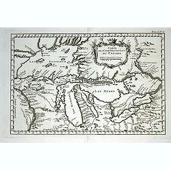
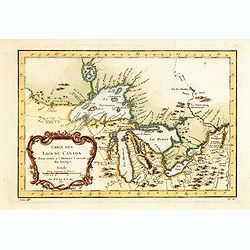
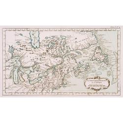
Carte des cinq Grands Lacs du Canada.
A good engraved map of the Great Lakes area, showing the imaginary islands of Philippeaux and Pontchartrain in Lake Superior. From l'Histoire générale des voyages .Bell...
Date: Paris, 1764
Selling price: ????
Please login to see price!
Sold in 2013
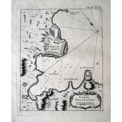
Plan de Porto Longon (Elba)
Detailed sea-chart of Porto Longone [Porto Azzurro] on Elba Island. Shows the villages and fortifications, depth soundings and anchoring places. Published in Bellin's fam...
Date: Paris, 1764
Selling price: ????
Please login to see price!
Sold in 2015
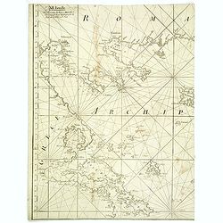
XII Feuille. (Chart of northern part of Greece with Thessaloniki)
Detail of a larger chart of Northern part of Greece, prepared by Bellin and published by J. Roux. The left half of chart XII from Joseph Roux's Carte de La Mer Meriterane...
Date: Marseille, 1764
Selling price: ????
Please login to see price!
Sold in 2013
![Hèmisphère Celeste Antarctique ou Austral. . . [together with] Hèmisphère Celeste Antarctique ou Septentrional. . .](/uploads/cache/34119-250x250.jpg)
Hèmisphère Celeste Antarctique ou Austral. . . [together with] Hèmisphère Celeste Antarctique ou Septentrional. . .
Map printed in two colors, black for the stars, red for the constellation figures.Uncommon set of large-scale celestial charts of the southern and northern hemispheres ca...
Date: Paris, Delamarche, after 1764
Selling price: ????
Please login to see price!
Sold in 2014
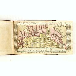
A Collection of Plans of the Principal Cities of Great Britain and Ireland, with Maps of the Coast of the Said Kingdoms. . .
A charming pocket atlas divided into two sections, firstly a series of 21 coastal and island plans detailing harbours and shoals round Great Britain and Ireland.The secon...
Date: London, A. Dury, 1764
Selling price: ????
Please login to see price!
Sold in 2015
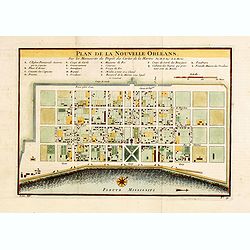
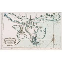
Plan De La Nouvelle-Orleans Sur les Manuscrits du Depot des Cartes De la Marine . . .
An important transitional and very detailed early map of New Orleans, copied after the original manuscript plan of the city drafted by Le Blond de la Tour in 1722. - the ...
Date: Paris, 1764
Selling price: ????
Please login to see price!
Sold in 2014
Carte Des Lacs Du Canada Pour sevir a l'Histoire Generale des Voyages.
Showing the all the Great Lakes in the traditional Bellin configuration. Jacques Nicolas Bellin (1703-1772) was one of the most important and proficient French cartograph...
Date: Paris, 1764
Selling price: ????
Please login to see price!
Sold in 2014
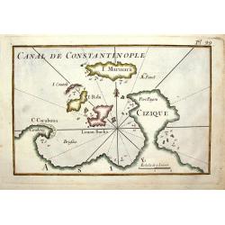
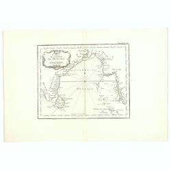
Canal de Constantinople.
A quaint little map featuring the Canal of Constantinople in Turkey. It was engraved by J. Roux in France in 1764.
Date: Paris, 1764
Selling price: ????
Please login to see price!
Sold in 2014
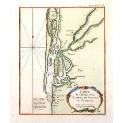
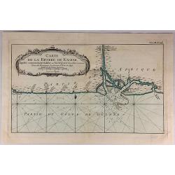
Carte de L'Entree de la Riviere de Sanaga ou Senegal.
The Sanaga River is a river of South Province, Cameroon. The map was published in 1764 by Nicholas Bellin in Paris.
Date: Paris, 1764
Selling price: ????
Please login to see price!
Sold in 2016
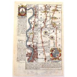
The Road from London to the Lands-End in Cornwall.
Attractive and decorative 18th century strip map showing the route from London to Cornwall. It was published in "Britannia Depicta". The strip road maps of Engl...
Date: London, 1720 - 1764
Selling price: ????
Please login to see price!
Sold in 2015
Bosphorvs Thracicvs : der Kanal des Schwartzen Meers oder die Meer-Enge bey Constantinopel sambt denen an beiden ufern desselben gelegenen Stätten, Flecken, Dörffern, Schlössern, Palaesten, Lusthäusern, Wasserleitungen. . .
Rare and detailed map of the Bosporus, shows names of villages, towns, drainage, vegetation, and other points of interest. In top text columns.
Date: Nuremberg, 1764
Selling price: ????
Please login to see price!
Sold in 2015
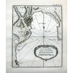
Plan du port ville et chateau de Ville-Franche.
Detailed chart which shows forts and buildings in Villefranche-sur-Mer . Decorative title cartouche. Relief shown pictorially. Depth shown by soundings. Engraved by Grois...
Date: Paris, 1764
Selling price: ????
Please login to see price!
Sold in 2015
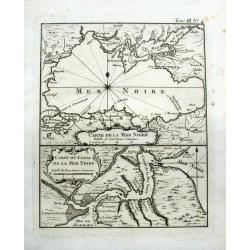
Carte de la Mer Noire & Carte du Canal de la Mer Noire.
Two maps, one sheet. On top is a detailed map of the Black Sea and Crimea, showing major cities and rivers. Below with a map of the Bosporus showing Constantinople (Istan...
Date: Paris, 1764
Selling price: ????
Please login to see price!
Sold in 2016
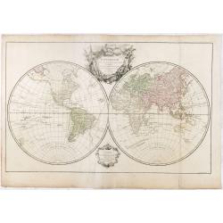
Mappemonde dressée suivant les nouvelles relations et assujettie aux observations astronomiques Par le S. Robert de Vaugondy. . .
World map in double hemispheres showing numerous tracks, among Anson, Cooke, Tasman and the Gold Galleons.With privilege of 1764, not mentioned by Pedley. Engraved by the...
Date: Paris, 1764
Selling price: ????
Please login to see price!
Sold in 2018
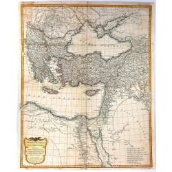
Orbis Romani Pars Orientalis Auspiciis Serenissimi Principis....
Large format map of the Eastern part of the Roman Empire, published by D'Anville. The map extends from Greece and the Balkans in the west to Iran in the east, and is cent...
Date: Paris, 1764
Selling price: ????
Please login to see price!
Sold in 2016
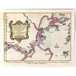
Carte de la Baye d'Hocsieu et des Entrees de la Riviere de Chang Situes dans la Province de Fokyen...
A striking antique map of the mouth of the Yangtze River China by the French cartographer, Nicolas Bellin. Published in Antoine-François Prevost's “ L`Histoire General...
Date: Paris, 1764
Selling price: ????
Please login to see price!
Sold in 2019
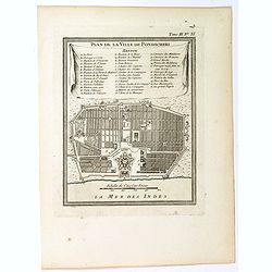
Plan de la Ville de Pondicheri.
A pretty small plan of the south eastern Indian city of Pondicherry. Over the centuries it has been ruled by the French (mostly), the Dutch and the English (occasionally)...
Date: Paris, 1764
Selling price: ????
Please login to see price!
Sold in 2018
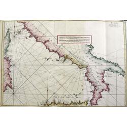
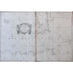
IV FEUILLE
A fantastic large sea-chart from Roux's famous CARTE DE LA MEDITERRANEE EN DOUZE FEUILLES. This is sheet number four of twelve, showing the south of Italy, the island of ...
Date: Marseille, 1764
Selling price: ????
Please login to see price!
Sold in 2021
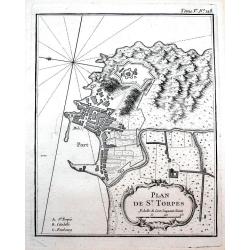
Plan de St. Torpés.
Detailed chart which shows the port, the fort and buildings in Saint-Tropez. Decorative title cartouche. Relief shown pictorially. Published in Bellin's famous "Le P...
Date: Paris, 1764
Selling price: ????
Please login to see price!
Sold in 2016
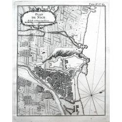
Plan de Nice.
Detailed chart of Nice and its surrounding area. Indicated the outline of buildings, streets, and the fortifications. Decorative title cartouche. Published in Bellin's fa...
Date: Paris, 1764
Selling price: ????
Please login to see price!
Sold in 2016
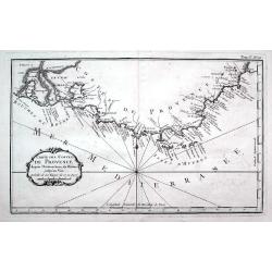
Carte des costes de Provence...
A detailed copper engraved map of Provence with the French Riviera, from the mouth of the Rhône, Arles and the Camargue to Nice. Including Marseille, Toulon, Saint-Trope...
Date: Paris, 1764
Selling price: ????
Please login to see price!
Sold in 2016
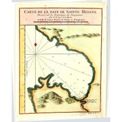
Carte de la Baye de Sainte Helene
An attractive outline chart of the coast of St Helena Bay, northwest of Cape Town, on the Atlantic coast of South Africa, by Bellin, the leading French hydrographer of th...
Date: Paris, 1764
Selling price: ????
Please login to see price!
Sold in 2016
![[2 maps] Orbis Romani pars Occidentalis / Pars Orientalis...](/uploads/cache/38420-250x250.jpg)
[2 maps] Orbis Romani pars Occidentalis / Pars Orientalis...
A pair of large folding maps by d'Anville, that joined together make up the Roman Empire (combined map size approx. 1370 x 1110 mm). Western sheet comprised of western E...
Date: Paris, 1764
Selling price: ????
Please login to see price!
Sold in 2018
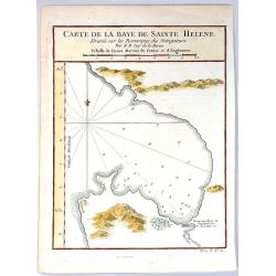
Carte de la Baye de Sainte Helene.
A map of St. Helena Bay on the Atlantic coast of South Africa. From the Dutch edition of Prevost's' Voyages'.Jaques Nicolas Bellin (1702-1772) was the most important Fren...
Date: Paris, 1764
Selling price: ????
Please login to see price!
Sold in 2016
Carte du Golphe de Bengale.
An uncolored example of the Gulf on Bengal from Bellin's "Le Petit Atlas Maritime". Showing the island of Ceylon (Sri Lanka), the east coast of India, across in...
Date: Paris, 1764
Selling price: ????
Please login to see price!
Sold in 2017
A New and Correct Chart of the Sea Coast of New England from Cape Codd to Casco Bay. . .
Two sheets, each 480 x 585 mm., not joined. This is one of the rarer of the large sea charts of New England to appear in Mount & Page's 'English Pilot Fourth Book'.Th...
Date: London, 1764
Selling price: ????
Please login to see price!
Sold in 2017
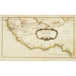
Carte de la Riviere de Kalbar...
A detailed coastal map of this Guinea coast area of Western Africa, based upon the 1699 voyage of James Barbot & John Grazilhier to New Kalabar, Bandi, and Doni River...
Date: Paris, 1764
Selling price: ????
Please login to see price!
Sold in 2018
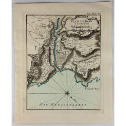
Plan D'Oran et Ses Environs.
A fine nautical chart of the fortified city of Oran in Algeria. It was published in LE PETIT ATLAS MARITIME. It features a decorative cartouche. Jacques Bellin (1703 – ...
Date: Paris, 1764
Selling price: ????
Please login to see price!
Sold in 2018
The Coast of the Mediterranean Sea from C. Tenelles to C. Bon, including the Islands of Minorca and Sardinia.
Very rare sea-chart showing the area from Minorca until the coast of Sicily, including most of Sardinia, Pantelleria, and a part of North Africa. With many place names al...
Date: London, 1764
Selling price: ????
Please login to see price!
Sold in 2018
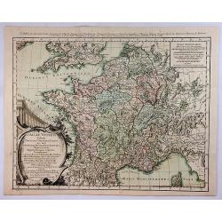
Galliae Veteris Tabula Populus. . .
This attractive copper-engraved map shows France with the ancient Roman names in Gaul. The detailed map depicts mountains, rivers, roads, and numerous towns. A beautiful ...
Date: Venice, 1764
Selling price: ????
Please login to see price!
Sold in 2020
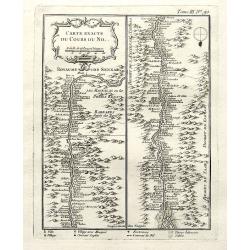
Carte exacte du cours du Nil.
A very detailed map of the Nile river. The banks are filled with place names of forts and villages. The river mouth is at the foot of the map. With a decorative title car...
Date: Paris, 1764
Selling price: ????
Please login to see price!
Sold in 2018
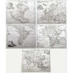
Set of four continents (Maps of North America; South America; Asia; Europe; Africa;)
Interesting set of five detailed maps of the continents. North America with large unexplored parts. Asia with unfinished coast lines and showing a "Companys Land&quo...
Date: London, 1764
Selling price: ????
Please login to see price!
Sold in 2018
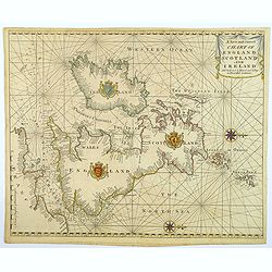
A New and Correct Chart of England Scotland and Ireland.
A striking sea chart of the British Isles, centered on the Isle of Man, published by Mount and Page in London, in the latter half of the eighteenth century. The chart is ...
Date: London, 1764
Selling price: ????
Please login to see price!
Sold in 2022
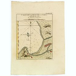
Carte de la Baye de la Table, et Rade du Cap de Bonne Esperance.
This nicely hand colored map is a copperplate map of the Cape of Good Hope, and of Cape Town, in South Africa. This map was issued both in Bellin's Le Petit Atlas Maritim...
Date: Paris, 1764
Selling price: ????
Please login to see price!
Sold in 2018
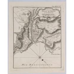
Plan d'Oran et Ses Environs.
A fine nautical chart of the fortified city of Oran in Algeria. It was published in “LE PETIT ATLAS MARITIME”. It features a decorative cartouche. Jacques Bellin (170...
Date: Paris, 1764
Selling price: ????
Please login to see price!
Sold in 2019
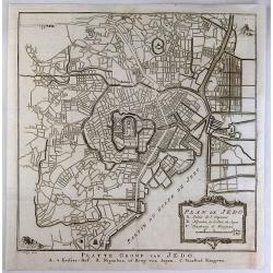
Plan de Jedo.
An antique city plan of the city and port of Tokyo, Japan built for the Dutch (VOC - Dutch East India Company) concession, on the Japanese island of Kyushu. Published by ...
Date: Paris, 1764
Selling price: ????
Please login to see price!
Sold in 2020
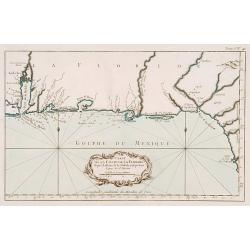
Carte Reduite des Costes de la Louisiane et de la Floride.
A very rare and large original engraved sea chart by Bellin from 1764. Details include Florida, the Gulf Coast and the Mississippi Valley. This is one of the best example...
Date: Paris, 1764
Selling price: ????
Please login to see price!
Sold in 2018

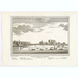
Vue de Peking tiree de Nieuhof.
This handsome view shows Beijing from the countryside, showing the city rising above its massive ancient walls. When Nieuhof visited Peking in the 1650s, the city was the...
Date: Paris, 1764
Selling price: ????
Please login to see price!
Sold in 2019
Vue du Chateau de Batavia.
A nice view of Batavia (now Jakarta in Indonesia) then under the control of the Dutch VOC. Many vessels are seen off the harbor, beneath the print is a lettered legend (A...
Date: Paris, ca 1764
Selling price: ????
Please login to see price!
Sold in 2020
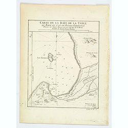
Carte de la Baye de la Table, et Rade du Cap de Bonne Esperance.
A nice copperplate map of the Cape of Good Hope, and of Cape Town, in South Africa. This map was issued both in Bellin's Le Petit Atlas Maritime and in the French edition...
Date: Paris, 1764
Selling price: ????
Please login to see price!
Sold in 2021
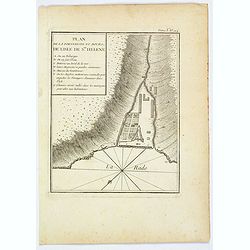
Plan de la Forteresse et Bourg, de Lisle de Ste. Helene.
A plan of the Fortress and Borough on the island of St. Helena by Bellin. With an inset legend of several important items and places of note, including the Govenor's hous...
Date: Paris, 1764
Selling price: ????
Please login to see price!
Sold in 2021
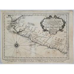
Partie de la Coste de Guinee.
A detailed map of the Guinea coast in West Africa, from the Sierra Leone River to Cape Palmas on the southern coast of what is now Liberia, from the atlas of Prevost d'Ex...
Date: Paris, 1764
Selling price: ????
Please login to see price!
Sold in 2019
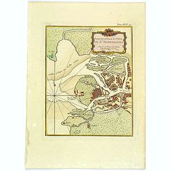
Plan de la Ville et Port de St. Petersbourg.
A nice and attractive map of St Petersburg by Bellin published in "Le Petit Atlas Maritime" and shows the city in detail along with the surrounding waterways. T...
Date: Paris, 1764
Selling price: ????
Please login to see price!
Sold in 2020
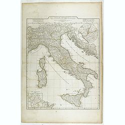
Tabula Italiae Antiquae. . .
Detailed map of Ancient Italy, including Corsica, Sardinia and Sicily.
Date: Rome, 1764
Selling price: ????
Please login to see price!
Sold in 2023
![De la Geologie. Du Zodiaque et du L' Eclyptique, Explication des Saisons. [Lot of 3 maps]](/uploads/cache/IMG_0104-250x250.jpg)
De la Geologie. Du Zodiaque et du L' Eclyptique, Explication des Saisons. [Lot of 3 maps]
Claude Buy de Mornas (d. 1783), géographe du roi (1764). Atlas Méthodique et Elémentaire de Géographie et d' Histoire, 1761, Atlas Historique et Géographique, 1762. ...
Date: Paris, 1762-1764
Selling price: ????
Please login to see price!
Sold in 2023
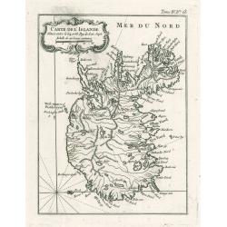
Carte De L'Islande
This elegant of Iceland by Bellin was published as part of his ‘Le Petit Atlas Maritime…’, which covered the world to the extent it was known and is one of the fine...
Date: Paris, 1764
Selling price: ????
Please login to see price!
Sold in 2023
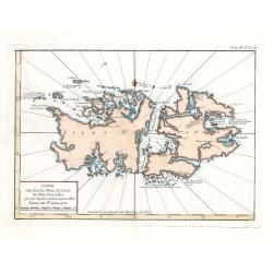
Carte Des Isles Malouines ou Isles Nouvelles - Isles de Falkland
This elegant sea chart of the Falkland Islands by Jacques Nicolas Bellin is from his ‘Le Petit Atlas Maritime…’, which covered the world to the extent it was known ...
Date: Paris, 1764
Selling price: ????
Please login to see price!
Sold in 2023
![[Lot of 12 maps] INDIA maps+gravures - Carte De La Baye De Trinquemale Dans L’Isle De Ceylon](/uploads/cache/4100003-250x250.jpg)
[Lot of 12 maps] INDIA maps+gravures - Carte De La Baye De Trinquemale Dans L’Isle De Ceylon
[Lot of 12] INDIA maps + gravure - Carte De La Baye De Trinquemale Dans L’Isle De Ceylon.- Platte Grond van t'Fort Tricoen male met de daar aangelegen Pagoods-Berg...
Date: 1764
Selling price: ????
Please login to see price!
Sold in 2023
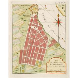
Plan de la Ville de Paramaribo Suivant les Plans Hollandois
Fine map of Panama Bay. From "Petit Atlas Maritime ". Jacques Nicolaas Bellin (1703-1772) was one of the most important and proficient French cartographers of t...
Date: Paris 1764
Selling price: ????
Please login to see price!
Sold
![[63] Alexandrette.](/uploads/cache/12835-250x250.jpg)
[63] Alexandrette.
"Charming chart of the harbour of the town of Alexandretta in Syria. Showing town and harbour plan, with soundings, anchorages, rocks, shoals, fortifications and lig...
Date: Marseille 1764
Selling price: ????
Please login to see price!
Sold
![[68] Barbarie.](/uploads/cache/12840-250x250.jpg)
[68] Barbarie.
Charming of the coast near to Sfax and the island of Djerba. Showing town and harbour plan, with soundings, anchorages, rocks, shoals, fortifications and lighthouses.Jos...
Date: Marseille, 1764
Selling price: ????
Please login to see price!
Sold in 2014
![[70] Tunis.](/uploads/cache/12842-250x250.jpg)
[70] Tunis.
Charming chart of the coasts near the town of Tunis. Showing town and harbour plan, with soundings, anchorages, rocks, shoals, fortifications and lighthouses.Joseph Roux ...
Date: Marseille 1764
Selling price: ????
Please login to see price!
Sold in 2014
![[73] Barbarie. Oran..](/uploads/cache/12845-250x250.jpg)
[73] Barbarie. Oran..
"Charming chart of the harbour of the town of Oran in Algeria. Showing town and harbour plan, with soundings, anchorages, rocks, shoals, fortifications and lighthous...
Date: Marseille 1764
Selling price: ????
Please login to see price!
Sold in 2014
![[75] Barbarie.. Mamora.. Salee](/uploads/cache/12905-250x250.jpg)
[75] Barbarie.. Mamora.. Salee
"Charming chart of including the harbours of Mamora, Salee, etc. Showing town and harbour plan, with soundings, anchorages, rocks, shoals, fortifications and lightho...
Date: Marseille 1764
Selling price: ????
Please login to see price!
Sold in 2014
La Nouvelle France où Canada.
This chart shows the territories of New-France and Canada the day before the signature of the treaty of Paris.The only issue of this version of Bellin's map, slightly lar...
Date: Paris 1764
Selling price: ????
Please login to see price!
Sold
Cours du Fleuve Saint Louis..
The mouth of the River Mississippi, depths shown by soundings. The only issue of this version of Bellin's map, slightly larger than the standard version. From Bellin's Pe...
Date: Paris 1764
Selling price: ????
Please login to see price!
Sold
Carte de la coste de la Floride..
Shows the Florida panhandle to Mobile Bay. Little interior data was known. The only issue of this version of Bellin's map, slightly larger than the common version. From B...
Date: Paris 1764
Selling price: ????
Please login to see price!
Sold
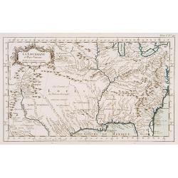
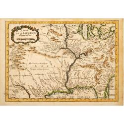
La Louisiane et Pays voisins.
The only issue of this version of Bellin's map, slightly larger than the common version. Excellent detail in the Santa Fe area. More than a dozen rivers, many with names ...
Date: Paris 1764
Selling price: ????
Please login to see price!
Sold
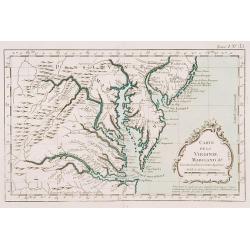
Carte de la Virginie Mari-Land &a.
Shows Virginia, Maryland, Delaware, and southern PA & New Jersey. From Bellin's Petit atlas maritime.Tome I N_35.Jacques Nicolas Bellin (1703-1772) was one of the mos...
Date: Paris 1764
Selling price: ????
Please login to see price!
Sold
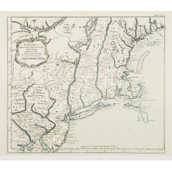
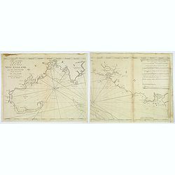
Carte de la Nouvelle Angleterre New York Pensilvanie..
Fine map of New England. From Bellin's Petit atlas maritime.Tome I N_29.Jacques Nicolas Bellin (1703-1772) was one of the most important and proficient French cartographe...
Date: Paris 1764
Selling price: ????
Please login to see price!
Sold
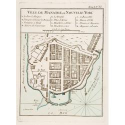
Ville de Manathe ou Nouvelle-Yorc.
This map, which was meant to show New York City, is the printed version of a hand drawn map by J.B.L. Franquelin in 1693.From the Bellin's Petit atlas maritime. In upper ...
Date: Paris 1764
Selling price: ????
Please login to see price!
Sold
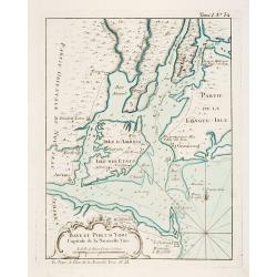
Baye et Port d'Yorc Capitale de la Nouvelle Yorc.
A great little map of the entrance of New York Harbour. The city is shown as a tiny village with other settlements including Neversink, Gravesend, Newark, Woodbridge and ...
Date: Paris 1764
Selling price: ????
Please login to see price!
Sold
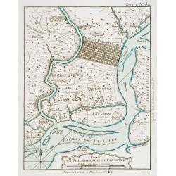
Plan de Philadelphie et Environs.
Nice early plan of the city of Philadelphia and vicinity depicting roads and scattered farms. Decorative title cartouche and fleur-de-lis. With manuscript reference to an...
Date: Paris 1764
Selling price: ????
Please login to see price!
Sold
Carte de la Louisiane et Pays Voisins.
A very rare map of Louisiana, Texas and central north America, from Le Commerce de l'Amérique par Marseille, ou Explication des Lettres-Patentes du Roi, portant Reglemen...
Date: Avignon 1764
Selling price: ????
Please login to see price!
Sold in 2016
Carte des Costes de Guinée.
A very rare map of western part of Africa with the Ivory coast, from Le Commerce de l'Amérique par Marseille, ou Explication des Lettres-Patentes du Roi, portant Regleme...
Date: Avignon 1764
Selling price: ????
Please login to see price!
Sold
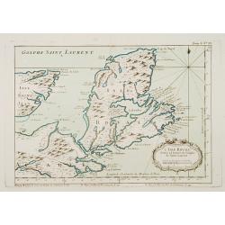
L'Isle Royale située à l'entrée du Golphe de Saint Laurent.
This chart shows the territories of Nova Scotia.The only issue of this version of Bellin's map, slightly larger than the common version. Depths shown by soundings.From Be...
Date: Paris 1764
Selling price: ????
Please login to see price!
Sold
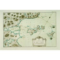
Plan de la Rade et Port de l'Isle Saint-Pierre.
This chart shows a detailed part of the east coast of the island Saint Pierre and Miquelon, which is now-a-day's still French territory.The only issue of this version of ...
Date: Paris 1764
Selling price: ????
Please login to see price!
Sold
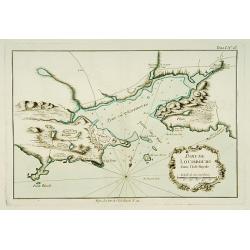
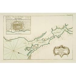
Port de Louisbourg dans l'Isle Royale.
This chart shows the harbour of Louisburg in the southeast portion of the island Nova Scotia in great detail.The only issue of this version of Bellin's map, slightly larg...
Date: Paris 1764
Selling price: ????
Please login to see price!
Sold
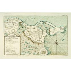
Plan de la ville de Louisbourg dans l'Isle Royale.
A plan of the city of Louisburg on l'Isle Royale.The only issue of this version of Bellin's map, slightly larger than the common version. Depths shown by soundings.From B...
Date: Paris 1764
Selling price: ????
Please login to see price!
Sold
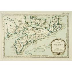
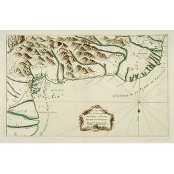
Carte de l'Acadie et Pays Voisins.
Fine chart shows in good detail Prince Edward Island, here called Isle Saint Jean, and covers all of Nova Scotia including Cape Breton. Locates numerous banks south of No...
Date: Paris 1764
Selling price: ????
Please login to see price!
Sold
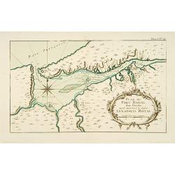
Plan du Port Royal dans l\'Acadie, Appelé Aujourd\' par les Anglois Annapolis Royal.
This chart shows the territories of Port Royal in Acadia.The only issue of this version of Bellin\'s map, slightly larger than the common version. Depths shown by soundin...
Date: Paris 1764
Selling price: ????
Please login to see price!
Sold
Plan de la Baye de Chibouctou nommée par les Anglois Halifax.
This chart shows the territories of Halifax in Nova Scotia, with an inset of the town.The only issue of this version of Bellin's map, slightly larger than the common vers...
Date: Paris 1764
Selling price: ????
Please login to see price!
Sold
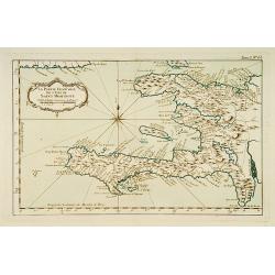
la Partie Francoise de l'Isle de Saint Domingue.
This chart shows the territories of what is today Haiti.The only issue of this version of Bellin's map, slightly larger than the common version. From Bellin's Petit atlas...
Date: Paris 1764
Selling price: ????
Please login to see price!
Sold
Environs de Leogane et du Port-au-Prince.
A highly detailed map of the area between Leogane and Port au Prince on Hispaniola, with a lovely decorative cartouche.The only issue of this version of Bellin's map, sli...
Date: Paris 1764
Selling price: ????
Please login to see price!
Sold
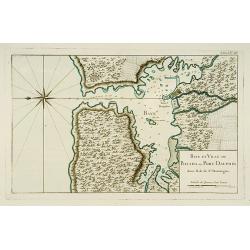
Baye et Ville de Bayaha ou Port Dauphin dans l'Isle de Saint-Domingue.
A detailed chart of the harbour of Banana on the north coast of what is today Haiti.The only issue of this version of Bellin's map, slightly larger than the common versio...
Date: Paris 1764
Selling price: ????
Please login to see price!
Sold
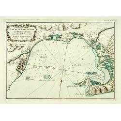
Plan de la Rade et Ville du Petit Goave dans l'Isle de St Domingue.
A very detailed chart of Petit Goave and l'Acul on the north coast of what is today Haiti.The only issue of this version of Bellin's map, slightly larger than the common ...
Date: Paris 1764
Selling price: ????
Please login to see price!
Sold
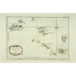
Petites Antilles ou Isle du Vent.. 3ème. Partie.
This chart shows The Windward Islands from the Virgin Islands to Antigua.The only issue of this version of Bellin's map, slightly larger than the common version. Depths s...
Date: Paris 1764
Selling price: ????
Please login to see price!
Sold
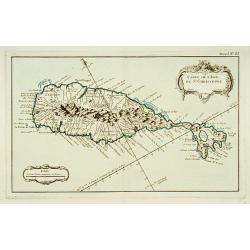
Carte de l'Isle de Saint-Christophe.
This chart shows the island of St. Kitts. Shows interesting topographic details, notes, ports, anchorages, etc.The only issue of this version of Bellin's map, slightly la...
Date: Paris 1764
Selling price: ????
Please login to see price!
Sold
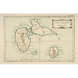
Isle de Guadeloupe les Saintes et Marie Galante.
This chart shows the islands of Guadeloupe, Les Saintes et Marie Galante.The only issue of this version of Bellin's map, slightly larger than the common version. Depths s...
Date: Paris 1764
Selling price: ????
Please login to see price!
Sold
![Partie occidentale de l'Isle de la Guadeloupe appellée la Basse Terre. / Partie Orientale de l'Isle de la Guadeloupe.. [2 maps]](/uploads/cache/17051-250x250.jpg)
Partie occidentale de l'Isle de la Guadeloupe appellée la Basse Terre. / Partie Orientale de l'Isle de la Guadeloupe.. [2 maps]
A set of 2 maps showing the northern and southern islands of Guadeloupe.The only issue of this version of Bellin's maps, slightly larger than the common version. Depths s...
Date: Paris 1764
Selling price: ????
Please login to see price!
Sold