Browse Listings
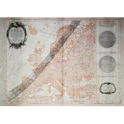
Passage de l' Ombre de la Lune au travers de l' Europe? 1er Avril 1764. / Fases de l' Eclipse telles qu'on les obsevera a Paris.
A highly uncommon map of Europe in sepia printing with superposed in black printing the track of the solar eclips of the 1st of April 1764.Calculated and engraved entirel...
Date: Paris, 1764
Selling price: ????
Please login to see price!
Sold
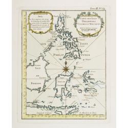
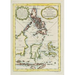
Carte Des Isles Philippines Celebes et Moluques.
Attractive map of the region showing the islands of the Philippines, Suluwesi, the Moloccus, Timor, Flores, Bali, and parts of Borneo and Java. There is no interior detai...
Date: Paris 1764
Selling price: ????
Please login to see price!
Sold
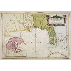
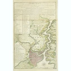
Carte Reduite Des Costes De La Louisiane Et De La Floride..
A well engraved and highly detailed chart of Florida, the Gulf Coast and the Mississippi Valley. This is one of the best examples of Florida as an Archipelago.The region ...
Date: Paris 1764
Selling price: ????
Please login to see price!
Sold in 2013
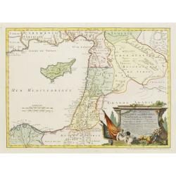
Carte Générale de la Syrie / Palestine / Isle de Chypre..
A very fine map of Syria, Palestine, and the island of Cyprus with part of the surrounding countries, prepared for the understanding of the history of the Crusades by Gui...
Date: Paris/ Bordeaux 1764
Selling price: ????
Please login to see price!
Sold
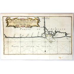
![[untitled] Balearic: Isle Fromentiere & Ivice](/uploads/cache/90490-250x250.jpg)
[untitled] Balearic: Isle Fromentiere & Ivice
Important chart of the island of Formentera and the southern part of Ibiza. Published in Roux's influental "Recueil des principaux plans des ports et rades de la Med...
Date: Paris 1764
Selling price: ????
Please login to see price!
Sold in 2008
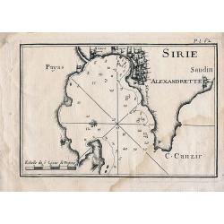
Sirie
Sea chart of Iskenderun in southern Turkey, close to the border to Syria. Published in Roux's influental work "Recueil des principaux plans des ports et rades de la ...
Date: Paris, 1764
Selling price: ????
Please login to see price!
Sold in 2010
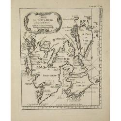
Carte du Spits-Berg
This map is from ''''Petit Atlas Maritime'''' and was etched by Croisey.
Date: 1764
Selling price: ????
Please login to see price!
Sold in 2008
![Plan de la Ville de Candie. [Iráklion]](/uploads/cache/25918-250x250.jpg)
Plan de la Ville de Candie. [Iráklion]
This chart shows the harbour of Iráklion. In lower part a key A-V, 1-12 to the bastions and gates of the town.From Bellin's Petit atlas maritime.Tome IV N119.Jacques Nic...
Date: Paris, 1764
Selling price: ????
Please login to see price!
Sold in 2023
Carte Des Isles Philippines Celebes et Moluques.
Attractive map of the region showing the islands of the Philippines, Sulawesi, the Moluccas, Timor, Flores, Bali, and parts of Borneo and Java. There is no interior detai...
Date: Paris, 1764
Selling price: ????
Please login to see price!
Sold in 2009
Carte du pais des Hottentots aux environs du Cap de Bonne Esperance.
Bellin\'s scarce vertical edition of the Cape of Good Hope. A finely colored engraving of the south-eastern coast of Africa around Cape Town. From the Le Petit Atlas Mari...
Date: Paris, 1764
Selling price: ????
Please login to see price!
Sold in 2008
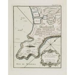
Plan de la ville et château de Gallipoli.
Nice detailed map of the Gallipoli peninsula located in Turkish Thrace (or East Thrace), in the European part of Turkey.The only issue of this version of Bellin's map, sl...
Date: Paris, 1764
Selling price: ????
Please login to see price!
Sold in 2014
Guyane Portugaise et Partie du Cours de la Riviere des Amazones.
A good engraved map of the Amazon.
Date: Paris, 1764
Selling price: ????
Please login to see price!
Sold in 2010
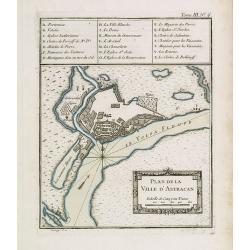
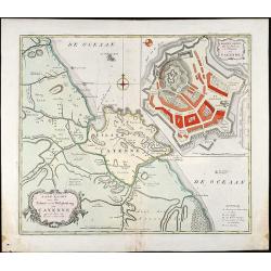
Plan de la ville d'Astracan.
Early town-plan of Astrakhan on the Volga River at the northern end of the Caspian Sea.Depths shown by soundings.From Bellin's Petit atlas maritime.Tome III N.6.Jacques N...
Date: Paris, 1764
Selling price: ????
Please login to see price!
Sold in 2012
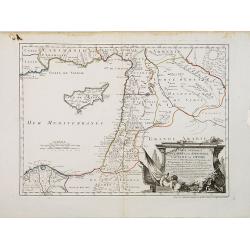
Carte Générale de la Syrie / Palestine / Isle de Chypre. . .
A very fine map of Syria, Palestine, and the island of Cyprus with part of the surrounding countries, prepared for the understanding of the history of the Crusades by Gui...
Date: Paris, ca. 1764
Selling price: ????
Please login to see price!
Sold

Dédiée à Monsieur Boucher Premier Peintre du Roy, Recteur et Directur de son Academie Royalle de Peinture et de Sculpture...
Title page etching by Jean-Baptiste Le Prince (1734-1781), for "2me Suite de divers cris de marchands de Russie", showing typical Russian costumes. The sketches...
Date: Paris, 1764
Selling price: ????
Please login to see price!
Sold in 2013
![[MANUSCRIPT] Carte nouvelle de la Crimée et des pays circonvoisins.](/uploads/cache/30484-250x250.jpg)
[MANUSCRIPT] Carte nouvelle de la Crimée et des pays circonvoisins.
A beautiful manuscript map on paper. Showing the northern part of the Black Sea region with Crimea.Interesting are the border lines of "New Serbia", shown in th...
Date: ca. 1752-1764
Selling price: ????
Please login to see price!
Sold in 2024
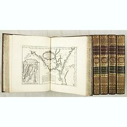
Le Petit atlas maritime. Recueil de cartes et plans des quatre parties du monde, en cinq volumes.
Important maritime atlas in five volumes, containing seven titles, dedication, 5 tables and 580 engraved maps and plans. Volume I: North America and the Caribbean, 102 m...
Date: Paris, 1764
Selling price: ????
Please login to see price!
Sold

(Title page) Premier livre de groupes d'enfants.
Etching by Pierre Aveline after François Boucher, title page in a breezy Rococo style.Underneath the print, lettered with name of designer and publication address: 'Huqu...
Date: Paris, Gabriel Huquier, 1764
Selling price: ????
Please login to see price!
Sold in 2011
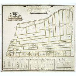
Voor den Weledelen Heer Mr Cornelis Pieter Pompe van Meerdervoort, Heere van Zwijndrecht. . .
Very fine and decorative map by Jan Govertsz van Linden, who was officially admitted as surveyor with by the court of Holland in 1736.According to the title the survey wa...
Date: Zwijndrecht, 27 october, 1764
Selling price: ????
Please login to see price!
Sold in 2011
Bosphorvs Thracicvs : der Kanal des Schwartzen Meers oder die Meer-Enge bey Constantinopel sambt denen an beiden ufern desselben gelegenen Stätten, Flecken, Dörffern, Schlössern, Palaesten, Lusthäusern, Wasserleitungen. . .
Rare and detailed map of the Bosporus, shows names of villages, towns, drainage, vegetation, and other points of interest. In top text columns.
Date: Nuremberg, 1764
Selling price: ????
Please login to see price!
Sold in 2011
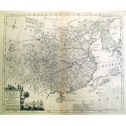
A New and Accurate Map of China, Drawn From Surveys Made by the Jesuit Missionaries. . .
Uncommon map by Kitchin, which appeared in "A Complete Collection of Voyages and Travels" by John Harris, printed for T. Osborne. The map closely resembles Thom...
Date: London, 1764
Selling price: ????
Please login to see price!
Sold in 2012
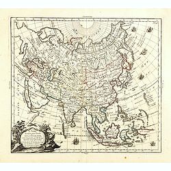
L'Asie, dressée pour l'étude de la Géographie . . .
Highly decorative map of Asia embellished with a landscape style title cartouche and several sailing ships.The map is of interest for the use of Mer de Corée, the sea be...
Date: Paris, 1765
Selling price: ????
Please login to see price!
Sold in 2023
Carte Reduite des Costes Occidentales d'Afrique seconde feuille depuis le Cap Bojador jusqu'a la Riviere de Sierra Leona pour le service des Vaisseaux du Roy... Seconde feuille..
Sea chart of the West African coast, from Sierra Leone to southern Morocco, and including the Cape Verde Islands and part of the Canaries, all at a scale of about 1:3,000...
Date: Paris 1754 corrected in 1765
Selling price: ????
Please login to see price!
Sold
Carte du Canal des Iles Philippines Par lequel passe le Galion de Manille, et les Iles voisines de ce Canal.
A map of the Philippines from a Dutch edition of Anson's Voyage around the World.
Date: Amsterdam, 1765
Selling price: ????
Please login to see price!
Sold in 2016
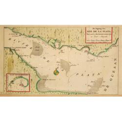
De Ingang van Rio de la Plata, Waar aan de Stad Buenos Ayres ligt, in Zuid-Amerika.
A map showing the Rio de la Plata estuary with the town of Buenos Aires. With an inset depicting the Bay of Maldonado.
Date: Amsterdam, 1765
Selling price: ????
Please login to see price!
Sold
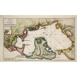
Plan van de Haven van Carthagena.
Izaak Tirion (d. 1769) Amsterdam publisher. His ' Nieuwe en beknopte handatlas' saw 6 editions between before 1740 and after 1784. Also ' Tegenwoordige staat van alle vol...
Date: Amsterdam, 1765
Selling price: ????
Please login to see price!
Sold
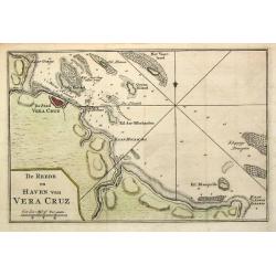
De Reede en Haven van Vera Cruz.
Izaak Tirion (d. 1769) Amsterdam publisher. His ' Nieuwe en beknopte handatlas' saw 6 editions between before 1740 and after 1784. Also ' Tegenwoordige staat van alle vol...
Date: Amsterdam,1765
Selling price: ????
Please login to see price!
Sold in 2020
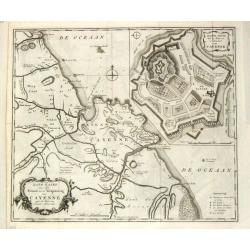
Land-kaart van het Eiland en de Volkplanting van Cayenne aan de Kust van Zuid-Amerika.
Izaak Tirion (d. 1769) Amsterdam publisher. His ' Nieuwe en beknopte handatlas' saw 6 editions between before 1740 and after 1784. Also ' Tegenwoordige staat van alle vol...
Date: Amsterdam, 1765
Selling price: ????
Please login to see price!
Sold

Amsterdam Town Hall - Royal Palace
The former Amsterdam Town Hall, now the Royal Palace. Copper engraving by Frans de Bakker after Reinier Vinkeles.From the history book of Amsterdam by Jan Wagenaar 1760 ...
Date: 1760-1765
Selling price: ????
Please login to see price!
Sold
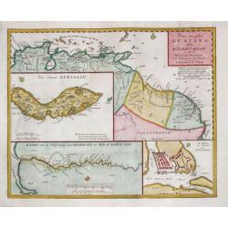
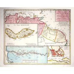
Kaart van geheel Guajana of de Wilden -Kust / Het Eiland Kurassau. / De Haven en \'t Kasteel van Kurassau / Kaart van de Volksplanting aan Demerary en Rio d\'Essequebo.
Isaak Tirion (d. 1769) Amsterdam publisher. His 'Nieuwe en beknopte handatlas' saw 6 editions between before 1740 and after 1784. Also 'Tegenwoordige staat van alle volke...
Date: Amsterdam, 1765
Selling price: ????
Please login to see price!
Sold in 2009
Kaart van het Onderkoningschap van Peru, zig uitstrekkende over Chili, Paraguay en andere Spaansche Landen: als ook van Brazil en verdere Bezitting en van Portugal in Zuid - Amerika.
Nice detailed map of most of the continent - leaving off the northern coastline. The southern tip is enclosed in a large inset balancing the composition with the block-st...
Date: Amsterdam, 1765
Selling price: ????
Please login to see price!
Sold
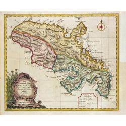
Het Westindisch Eiland Martenique.
Nice, decorative map of Martinique filled with good detail of roads, topography, soundings, villages, windmills, and plantations. The title cartouche incorporates the dis...
Date: Amsterdam, 1765
Selling price: ????
Please login to see price!
Sold
Carte de la Mer du Sud ou Mer Pacifique.
Unusual chart detailing the route of Spanish galleons between the Philippines and Acapulco. With the tracks of the British Centurion, commanded by George Anson and the Sp...
Date: Amsterdam, 1765
Selling price: ????
Please login to see price!
Sold in 2010
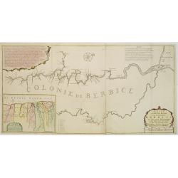
Nieuwe..kaart van de colonie Berbice..
Re-issue of his map from 1740, without the printed list of owners, with a large added contemp. hand-colored cartouche Relaas van de rebellie, ontstaan op de plantagien in...
Date: Amsterdam 1765
Selling price: ????
Please login to see price!
Sold
Carte Des Variations De La Boussole Et Des Vents Généraux Que L' On Trouve Dans Les Mers Les Plus Frequentées..
An elegantly designed chart of the oceans, according to the title "most frequently sailed by French navigators" in the eighteenth century. Drawn by J. N. Bellin...
Date: Paris, 1765
Selling price: ????
Please login to see price!
Sold in 2008
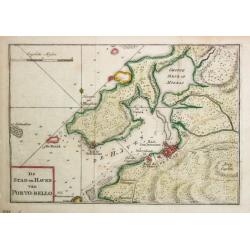
De Stad en Haven van Porto-Bello.
Izaak Tirion (d. 1769) Amsterdam publisher. His ' Nieuwe en beknopte handatlas' saw 6 editions between before 1740 and after 1784. Also ' Tegenwoordige staat van alle vol...
Date: Amsterdam, 1765
Selling price: ????
Please login to see price!
Sold
Het Westindische Eiland Marteneque.
Izaak Tirion (d. 1769) Amsterdam publisher. His ' Nieuwe en beknopte handatlas' saw 6 editions between before 1740 and after 1784. Also ' Tegenwoordige staat van alle vol...
Date: Amsterdam, 1765
Selling price: ????
Please login to see price!
Sold in 2010
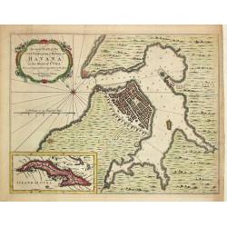
An exact Plan of the City, Fortifications & Harbour of Havana in the Island of Cuba.
John Hinton (fl.1745, d. 1781), London-based publisher, Universal Magazin 1747-1781. A plan of the town of Havana and direct vincinity. With an inset depicting Cuba. From...
Date: London, Newgate Street, 1752-1765
Selling price: ????
Please login to see price!
Sold in 2008
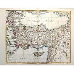
Asiae Quae Vulgo Minor Dicatur et Siriae.
Fine map of ancient Turkey featuring the Black Sea, Mediterannean Sea,and Aegean Sea and the islands of Cyprus and Crete. Also includes inserts of Troy & Bosphorus. ...
Date: Paris, 1765
Selling price: ????
Please login to see price!
Sold in 2016
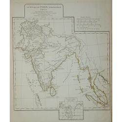
Ad antiquam Indiae geographiam tabula.
A map showing India with an inset in the lower part entitled Ptolemaicae Tabulae showing the island of Sri Lanka.
Date: Paris, 1765
Selling price: ????
Please login to see price!
Sold in 2011
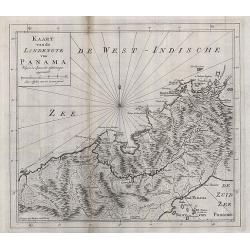
Kaart van de landengte van Panama.
Map of the Isthmus showing towns such as Panama, Chargres and Porto-Bello,&c., roads and villages of the time.
Date: Amsterdam, 1765
Selling price: ????
Please login to see price!
Sold in 2008
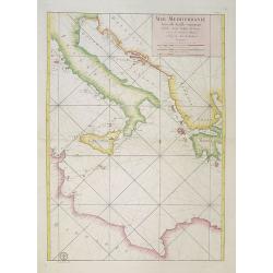
Mer Mediterranée Seconde Feuille contenant L' Italie, Sicile, Golphe de Venise.. Barbarie.
A well engraved and highly detailed chart of the eastern part of the Mediterranean, centered on Italy. Showing soundings, anchorage's, channels, shoals, navigational sigh...
Date: Paris, 1765
Selling price: ????
Please login to see price!
Sold in 2018
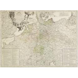
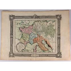
Carte D'Allemagne: Pour Servir A L'Intelligence De L'Histoire De La Guerre Entre Roys de France et D'Angleterre; Entre le Roy de Prusse et L'Impératrice Reine, L'Electeur De Saxe, L'Empire, La Suede, Et La Russie.
Large map on two sheets of Germany, Poland, the Netherlands, Belgium, Northern parts of France, Luxemburg and northern Italy.In lower left and right hand corners a two co...
Date: Paris, Beaurain, 1765
Selling price: ????
Please login to see price!
Sold in 2013
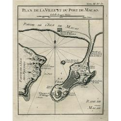
PLAN DE LA VILLE ET DU PORT DE MACAO
Bellin\'s important and interesting map of the bay and city of Macau. Macau was the first and the last European colony in China. It was under Portuguese control from the ...
Date: Paris, ca. 1765
Selling price: ????
Please login to see price!
Sold in 2008
Land-Kaart van het Eiland en de Volkplanting van Cayenne aan de Kust van Zuid-Amerika
Attractive engraved map of French Guyana by I. Tirion. Showing the coast of French Guyana with a plan of Cayenne and the fortifications. With two cartouches and a compass...
Date: Amsterdam, 1765
Selling price: ????
Please login to see price!
Sold in 2009
![[Six engraved gores for a 20cm diameter terrestrial globe, showing the western hemisphere]](/uploads/cache/27976-250x250.jpg)
[Six engraved gores for a 20cm diameter terrestrial globe, showing the western hemisphere]
Six engraved globe gores for a 20cm diameter terrestrial globe, published by Peter Anich (1723-1766), a Tyrolean shepherd who became an eminent geographer and maker of ma...
Date: Vienna, 1765
Selling price: ????
Please login to see price!
Sold in 2009
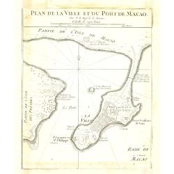
Plan de la ville et du port de Macao.
Bellin's important and interesting map of the bay and city of Macau. Macau was the first and the last European colony in China. It was under Portuguese control from the 1...
Date: Paris, ca. 1765
Selling price: ????
Please login to see price!
Sold in 2010
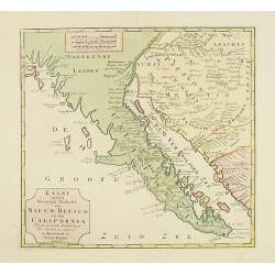
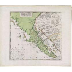
Kaart van het Westelyk Gedeelte van Nieuw Mexico en van California. . . MDCCLXV ..
A detailed map of the Baja California and Sonora, bounded on the north by the Colorado and Gila Rivers and approximately Mozatlan in the south, thus including parts of mo...
Date: Amsterdam, 1765
Selling price: ????
Please login to see price!
Sold in 2012
Collection of 9 eighteenth century maps including Paris, plus an attractive dedication page.
Taken from 'A MONSIEUR CASSINI DE THURY SEIGNIEUR DE VILLETANEUSE, Directeur de l'Observatoire Royal, Maitre des Comple[a] ASSOCIE Des Academies des Sciences de PARIS, LO...
Date: Paris, 1765
Selling price: ????
Please login to see price!
Sold in 2013
Derbyshire Divided into Hundreds
A map of ‘Derbyshire’ by Emanuel Bowen and Thomas Bowen, ca. 1765.An extremely rare map from Thomas Kitchin's 1765 edition of the "English Atlas". Thomas Ki...
Date: London, 1765
Selling price: ????
Please login to see price!
Sold in 2017
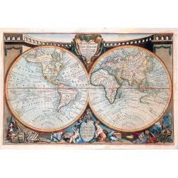
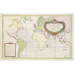
Mappemonde ou globe terestre dressée sur les Nouvelles Observations . . .
Scarce, spectacular world map which includes most of the major discoveries of the 18th-century explorers like Cook, Bougainville, Halley, etc. The maker, Jean Baptiste Lo...
Date: Peris, 1765
Selling price: ????
Please login to see price!
Sold in 2018
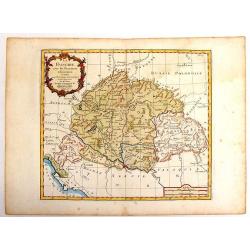
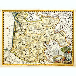
La Hongrie avec les Provinces.
Nice map of Hungary by Brion and published by Desnos. With Rococo style cartouche. Louis Brion de la Tour (1756-1823) was a geographer and demographer. His official tit...
Date: Paris, 1765
Selling price: ????
Please login to see price!
Sold in 2014
Carta Geographica del Governo della Normandie.
Engraved map of Normandy. The cartouche is remarkable and takes up more than one quarter of the space. Giambattista Albrizzi (1698-1777) was a Venetian publisher and jour...
Date: Venice, 1740-1765
Selling price: ????
Please login to see price!
Sold in 2013
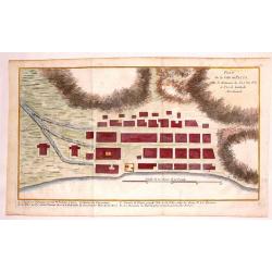
Plan de la Ville de Paita dans le Roiaume de Santa Fe.
Plan of the Peruvian city of Paita on the Santa Fe coast. The original map was produced by Captain George Anson during his voyage around the world. Jacob Van Der Schley...
Date: Amsterdam, 1765
Selling price: ????
Please login to see price!
Sold in 2013
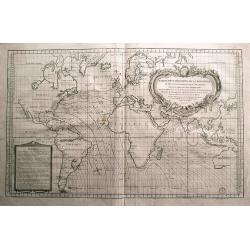
Carte des variations de la boussole...
Very large sea-chart of the world, showing compass variation and winds. The winds are shown by small cherubs! Australia is shown with unfinished coastline and named "...
Date: Paris, 1765
Selling price: ????
Please login to see price!
Sold in 2014
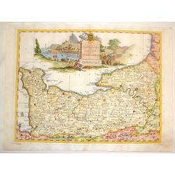
Carta geografica del governo di Guienna e Guascogna.
Detailed map of the south west coast of FranceAn uncommon pirate edition of the map originally published by Isaac Tirion. Taken from "Storia moderna di tutti I popol...
Date: Venice, 1740-1765
Selling price: ????
Please login to see price!
Sold
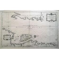
Carte Reduite du Detroit de Davids...
Highly interesting large-scale sea chart of the Davis Strait, which was created for whaling ships, and illustrates the importance of offshore activities in the region. Or...
Date: Paris, 1765
Selling price: ????
Please login to see price!
Sold in 2018
Kaart van geheel Guajana of de Wilden -Kust / Het Eiland Kurassau. / De Haven en 't Kasteel van Kurassau / Kaart van de Volksplanting aan Demerary en Rio d'Essequebo.
Izaak Tirion (d. 1769) Amsterdam publisher. His ' Nieuwe en beknopte handatlas' saw 6 editions between before 1740 and after 1784. Also ' Tegenwoordige staat van alle vol...
Date: Amsterdam, 1765
Selling price: ????
Please login to see price!
Sold in 2017
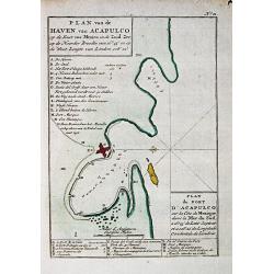
Plan van de haven van Acapulco.
A map of the fort and town of Acapulco. From a Dutch edition of Anson's Voyage around the World.2.
Date: Amsterdam, 1765
Selling price: ????
Please login to see price!
Sold in 2016
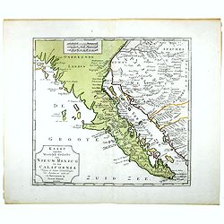
Kaart van het Westelyk gedeelte van Nieuw Mexico en van California
A detailed map of the Baja California and Sonora, bounded on the north by the Colorado and Gila Rivers and approximately Mozatlan in the south, thus including parts of mo...
Date: Amsterdam, 1765
Selling price: ????
Please login to see price!
Sold in 2014
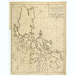
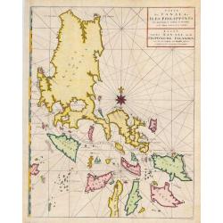
Carte du Canal des Iles Philippines Par lequel passe le Galion de Manille, et les Iles voisines de ce Canal / Kaart van het Kanaal in de Filippynsche Eilanden . . .
Important chart of the Islands of the Philippines. Shows islands, bays, reefs, soundings tracks of the Manila Galleon route, etc. Includes a large compass rose and rhumb ...
Date: Paris, 1765
Selling price: ????
Please login to see price!
Sold in 2016
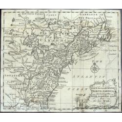
A New & Accurate Map of North America, Including the British Acquisitions gain'd By the late War. 1763
Scarce map of the eastern part of North America from James Bay to the Gulf of Mexico in the year 1763. It shows boundaries, colonies, towns, cities, forts, and Indian tri...
Date: London, ca. 1765
Selling price: ????
Please login to see price!
Sold in 2016
Kaart van het Westelyk Gedeelte van Nieuw Mexico en van California. . . MDCCLXV ..
A detailed map of the Baja California and Sonora, bounded on the north by the Colorado and Gila Rivers and approximately Mozatlan in the south, thus including parts of mo...
Date: Amsterdam, 1765
Selling price: ????
Please login to see price!
Sold in 2020
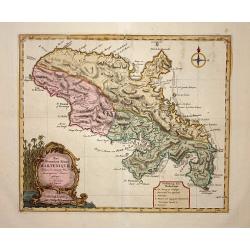
Carte de la Riviere de Kalbar.
A splendid coastal map of this Guinea coast area of Western Africa, the chart is based upon the 1699 voyage of James Barbot & John Grazilhier to New Kalabar, Bandi, a...
Date: Paris, 1765
Selling price: ????
Please login to see price!
Sold in 2016
Carte Reduite des Costes Occidentales d'Afrique seconde feuille depuis le Cap Bojador jusqu'a la Riviere de Sierra Leona pour le service des Vaisseaux du Roy... Seconde feuille..
Sea chart of the West African coast, from Sierra Leone to southern Morocco, and including the Cape Verde Islands and part of the Canaries, all at a scale of about 1:3,000...
Date: Paris, 1753 corrected in 1765
Selling price: ????
Please login to see price!
Sold in 2018
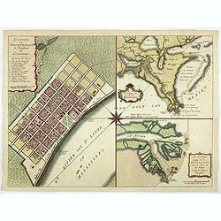
Grondvlakte van Nieuw Orleans de Hoofdstad van Louisiana. / De uitloop van de Rivier Missisippi./ De Oostelijke ingang van de Missisippi. . .
A sought-after, beautiful, decorative sheet that shows three maps arranged around a significant compass rose. This work represents Tirion's version of a first executed ma...
Date: Amsterdam, 1765
Selling price: ????
Please login to see price!
Sold in 2017
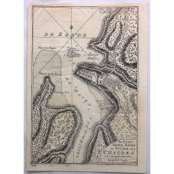
De Stad, Reede, Haven en Rivier van Chagres in de Spaansche Westindien.
A map of the town of Chagres and its direct vicinity. The Chagres River in central Panama is the largest in the Panama Canal's watershed.It was published in “Tegenwoord...
Date: Amsterdam, 1765
Selling price: ????
Please login to see price!
Sold in 2017
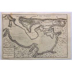
De Hoofdstad en Haven Van't Eiland Porto Rico, in de Westindien.
A detailed plan of San Juan Harbour in Puerto Rico, which appeared in Tirion's “Hedendaagsch Historie of Tegenwordige Staat van Amerika”.The map includes a detailed p...
Date: Amsterdam, 1765
Selling price: ????
Please login to see price!
Sold in 2023
Carte de l'Empire de Charle-Magne...
A highly detailed engraved 1764 map of the Empire of Charlemagne. It covers Europe and the European Empire of Charles the Great from Ireland south as far as northern Afri...
Date: Venice, 1765
Selling price: ????
Please login to see price!
Sold in 2017
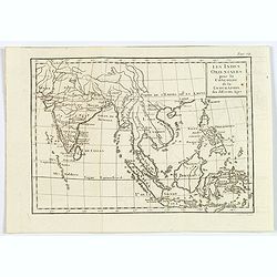
Les Indies Orientales pour la Concorde de la Geographie. . .
A nice small map of India and South East Asia, from the "Concorde de la Geographie des Differens Ages" by Freres Estienne.
Date: Paris, 1765
Selling price: ????
Please login to see price!
Sold in 2020
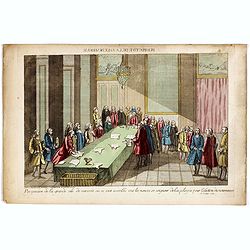
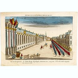
Perspective de la grande salle de varsovie ou se sont assemblé tout les nonces et seigneur de la pologne pour lélection du nouveau roi, le 6 Sept. 1764.
Uncommon optical print published in " Paris, chez Carcano, Faubourg Saint Antoine à cöté de la Boule Blanche". The print depicts the election of Stanislas II...
Date: Paris, Carcano, c.1765
Selling price: ????
Please login to see price!
Sold in 2018
Vue et perspective de l'entré du roy de pologne à varsovie avec une partie de la vile et de son palais.
The print depicts the arrival of Stanislas II Auguste Poniatowski (the last king of independent Poland (1732-1798) in Warsaw. Uncommon optical print published in " P...
Date: Paris, Basset, c.1765
Selling price: ????
Please login to see price!
Sold in 2020
A Plan of the Town and Harbour of Louisbourg. . . A Plan of the City and Harbour of Havana. . . A Plan of the Town and Harbour of Cartagena. . .
"A Plan of the Town and Harbour of Louisbourg [on sheet with] A Plan of the City and Harbour of Havana [and] A Plan of the Town and Harbour of Cartagena [and] A Plan...
Date: London, 1765
Selling price: ????
Please login to see price!
Sold in 2020
![Kaart van geheel GUAJANA of de WILDEN-KUST, en die der Spaansche Westindien [and] Het Eiland KURASSAU. [and] KAART van de Volkplanting aan DEMERARY en RIO D'ESSEQUEBO.](/uploads/cache/82588-250x250.jpg)
Kaart van geheel GUAJANA of de WILDEN-KUST, en die der Spaansche Westindien [and] Het Eiland KURASSAU. [and] KAART van de Volkplanting aan DEMERARY en RIO D'ESSEQUEBO.
A scarce hand-colored map made from four maps together on one sheet, showing the Dutch colonies on the north coast of South America, including Curaçao and Willemstad. Wh...
Date: Amsterdam, 1765
Selling price: ????
Please login to see price!
Sold in 2019
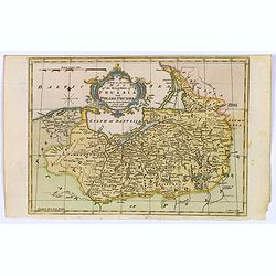
A New & Accurate Map of the Kingdom of Prussia and Polish Prussia.
The map covers the area from Pomerania east to Lithuania. Shows numerous place names, rivers and topography. Decorated by a decorative title cartouche. Compass rose and m...
Date: London, 1765
Selling price: ????
Please login to see price!
Sold in 2021
Carte de L'Isle de Madagascar. . .
A fine early sea chart of the African island of Madagascar, published by the French Hydrographical Department. An attractive large-scale chart full of interesting topogra...
Date: Paris, 1765
Selling price: ????
Please login to see price!
Sold in 2019
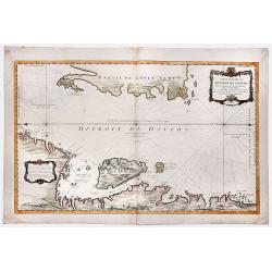
Carte Reduite du DETROIT DE DAVIDS. Faite an Depost des Cartes Plans et Journaux de la Marine, . . . MDCCLXV.
A beautiful, large chart of the French sea of the Davis Strait, published by Jacques Nicolas Bellin in Paris. The note at the bottom left indicates that the map was const...
Date: Paris, 1765
Selling price: ????
Please login to see price!
Sold in 2019
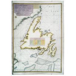
Carte de L'Ile de Terre-Neuve. Dressee d'apres les Plans Anglois de James Cook et Michael Lane. . .
A fine early sea chart of the Newfoundland and Labrador based upon early 18th century works , published by the French Hydrographical Department. This chart was produced b...
Date: Paris, 1765
Selling price: ????
Please login to see price!
Sold in 2020

A Plan of the City and Harbour of Havanna, Capital of the Island of Cuba.
A lovely small town plan of the Cuban capital city of Havana, probably published by Baldwin for the "London Magazine" in the mid 1760s. The plan highlights the ...
Date: London, ca 1765
Selling price: ????
Please login to see price!
Sold in 2020
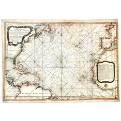
Carte Reduite de l' OCEAN OCCIDENTAL Contenant Partie des Costes d' Europe et d' Afrique... M DCCLXVI.
An decorative maritime chart, by the one of the greatest French hydrographers of the 18th century. In the context of the war at the end of the 18th century, and of the ri...
Date: Paris, 1766
Selling price: ????
Please login to see price!
Sold in 2019