Browse Listings
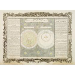
Centre du Monde. Systêmes de Ptolomée et de Ticho-Brahé.
Decorative celestial map representing the conception of the universe according to Ptolomaeus and Ticho-Brahé.Left and right a box with information about both systems.Pre...
Date: Paris, 1762
Selling price: ????
Please login to see price!
Sold
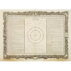
Définitions Préliminaires des Termes de Géométrie Nécessaires..
Decorative map illustrating the geometrical figures at the basis of geometry.Left and right a box containing the basic concepts of geometry.Prepared by Buy de Mornas, who...
Date: Paris 1762
Selling price: ????
Please login to see price!
Sold
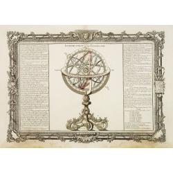
Introduction à la Géographie.
Decorative chart representing the celestial sphere.Left and right a box containing an introduction to geography.Prepared by Buy de Mornas, who was a professor of geograph...
Date: Paris 1762
Selling price: ????
Please login to see price!
Sold
L' Empire de Russie en Europe et en Asie.
Rigobert Bonne (1727-1795), French cartographer. His maps are found in a.o. Atlas Moderne (1762), Raynal's Histoire Philos. du Commerce des Indes (1774) and Atlas Encyclo...
Date: Paris, 1762
Selling price: ????
Please login to see price!
Sold
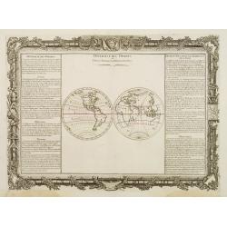
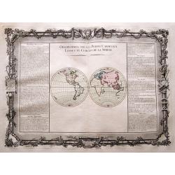
Diversité Des Ombres et Diverse Situation des Habitants de la Terre.
Decorative map of the world showing the system of shadows on the Earth depending on the different latitude and longitude degrees.Left and right a box with technical terms...
Date: Paris 1762
Selling price: ????
Please login to see price!
Sold
Climats d'Heures et de Mois.
Decorative map of the world showing one hemisphere divided into climates according to the length of the day.Left and right a box with information about these climates.Pre...
Date: Paris 1762
Selling price: ????
Please login to see price!
Sold
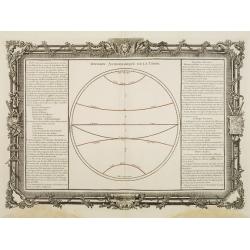
Division Astronomique de la Terre.
Decorative map of the world showing the astronomical division of the Earth as made by the geometricians.Left and right a box with information about the main lines, points...
Date: Paris 1762
Selling price: ????
Please login to see price!
Sold
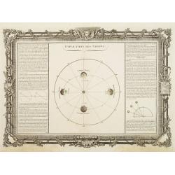
Explication des Saisons.
Decorative celestial chart representing the Earth's revolution around the sun.Left and right a box with information explaining the phenomenon of the seasons.Prepared by B...
Date: Paris 1762
Selling price: ????
Please login to see price!
Sold
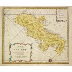
Carte de l\' Isle de la Martinique.
Homann Heirs (of Johann Baptist and Johann Christof) published: Grosser Atlas, 1731, 1737. Geogr. Maior, 1759, Atlas Homannianus, 1762.A map of the island of Martinique.
Date: Nürnberg, 1762
Selling price: ????
Please login to see price!
Sold in 2011
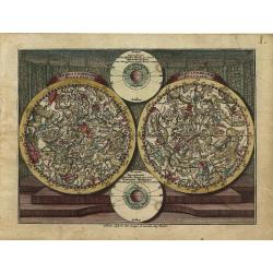
Hemisphaerium Boreale - Hemisphaerium Australe.
Handsome miniature celestial chart depicting the mythological form of the constellations in the Northern and Southern Hemispheres. Two ecliptic diagrams are tucked betwee...
Date: Augsburg, 1762
Selling price: ????
Please login to see price!
Sold
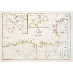
Carte Des Costes De Portugal et de Partie D'Espagne depuis le Cap de Finisterre Jusques au Dêtroit De Gibraltar.
Large scale chart of Portugal engraved by H. van Loon Sculp. With inset of the Bay of Lisbon and Cadiz.With rhumb lines radiating across the chart. Published by the Depot...
Date: Paris 1762
Selling price: ????
Please login to see price!
Sold
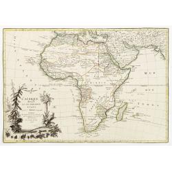
L'Afrique divisee en ses principaux etats par le sr. Janvier..
Excellent copper engraved map of the continent showing the extent of knowledge in the mid 18th century.While mostly accurate, it does have remnants of fantasy such as the...
Date: Paris 1762
Selling price: ????
Please login to see price!
Sold
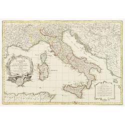
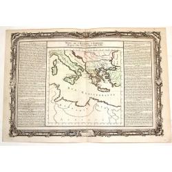
L´Italie divisée en ses differents Etats, Royaumes et Republiques..
Attractive map of Italy and including Corsica, Sardinia, Sicily, much of Provence and portions of the Balkans.Very decorative title cartouche, uncolored as issued. A seco...
Date: Paris 1762
Selling price: ????
Please login to see price!
Sold
Atlas moderne ou collection de cartes sur toutes les parties du globe terrestre par plusieurs auteurs.
Typical 18th century French atlas, including maps by Janvier, Rizzi Zannoni and Bonne. Decorative title page: two women holding the title in a large drape, the page is fi...
Date: Paris, Lattré, 1762
Selling price: ????
Please login to see price!
Sold
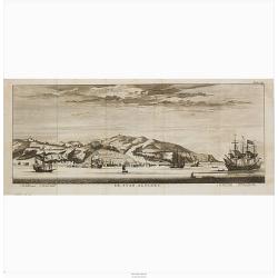
De Stad Algiers.
A view of the town of Algiers as seen from the sea.
Date: Amsterdam, 1762
Selling price: ????
Please login to see price!
Sold in 2020
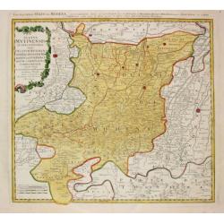
Status Mutinensis.
Homann Heirs (of Johann Baptist and Johann Christof) published: Grosser Atlas, 1731, 1737. Geogr. Maior, 1759, Atlas Homannianus, 1762.A map of Modena and the area around...
Date: Nürnberg, 1762
Selling price: ????
Please login to see price!
Sold
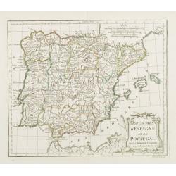
Royaumes d'Espagne et de Portugal.
Detailed map of Spain, Portugal and Baleares islands. Showing also southwestern part of France and north Africa.
Date: Paris, 1762
Selling price: ????
Please login to see price!
Sold
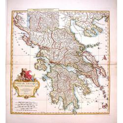
Graeciae Antiquae Specimen Geographicum.
Decorative map of Ancient Greece, with a large, decorative, Rococo, title cartouche. With an inset depicting northern Greece. Jean Baptiste d'Anville (1697-1782) born in...
Date: Paris, 1762
Selling price: ????
Please login to see price!
Sold in 2013
Nova Tabula Scaniae, que est Gothia Australis Provincias Scaniam, Hallandiam et Blekingiam.
Nova Tabula Scaniae, que est Gothia Australis Provincias Scaniam, Hallandiam et Blekingiam. Johan Baptist Homann (1663-1724). Outstanding German cartographer. Founder o...
Date: Nürnberg, 1762
Selling price: ????
Please login to see price!
Sold in 2021
Du Méridien et de l'Équateur.
Decorative chart of one hemisphere divided into meridians and showing the main celestial circles with the equator colored in red.Left and right a box with information abo...
Date: Paris, 1762
Selling price: ????
Please login to see price!
Sold in 2011
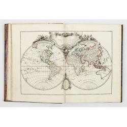
Atlas Geographicus portatilis XXIX mappis orbis habitabilis regna exhibens ... Kurzgefasste Geographie
Pocket atlas of T. Lotter and T. Lobeck. Bound with "Kurzgefasste Geographie" of Lobeck. With one world map, one celestial map, 4 continents and 37 european map...
Date: Augsburg, 1762
Selling price: ????
Please login to see price!
Sold in 2010
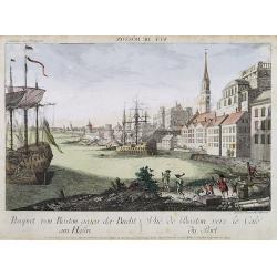
Prospect von Boston gegen der Bucht am Hafen. / Vue de Boston vers le Cale du Port.
A so-called optical print of a fanciful view of Boston harbour, two ships at anchor, British soldiers and men working, and merchandise on shore; an idealized view depicti...
Date: Augsburg, 1762
Selling price: ????
Please login to see price!
Sold
L'Irlande.
A first state (of 2) dated 1762. Fine map of Ireland, engraved by E.Dussy. Fine title cartouche upper left engraved by Arrivet. From his Nouvel Atlas Portatif .
Date: Paris, 1762
Selling price: ????
Please login to see price!
Sold in 2021
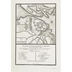
Plan de la ville et du fort St. Philippe dans l'Isle de Minorque assiégé le 8 mai par l'armée française aux ordres du Maréchal de Richelieu, occupé par les Français le 29 juin 1756.
A military plan of St. Philip's fortifications and fort on the Island of Minorca. With an inset map of Fort St. Philip with a key : 1-26. The model was made by Therbu. En...
Date: Paris, ca. 1762
Selling price: ????
Please login to see price!
Sold in 2009
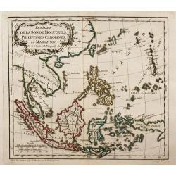
Les Isles de la Sonde, Moluques, Philippines, Carolines, et Mariannes.
Small detailed map of southeast Asia, showing the Malay Peninsula, Sumatra, Java and the island of Borneo.
Date: Paris, 1762
Selling price: ????
Please login to see price!
Sold in 2010
Ueberstetzung der Algemeinen Welthistorie die in England durch eine geselschaft von Gelehrten ausgefertigt worden vol. 24
Part of an extensive work on general world history, this volume focusing on Siam, CochinChina, Tartary, and China including a large fold-out map of China based on D'Anvil...
Date: Halle, 1762
Selling price: ????
Please login to see price!
Sold in 2011
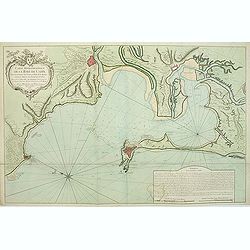
Carte hydrographique de la Baye de Cadix. . .
Uncommon of Cadiz and surroundings.Jacques Nicolaas Bellin (1703-1772) was one of the most important and proficient French cartographers of the mid-eighteenth century. H...
Date: Paris, 1762
Selling price: ????
Please login to see price!
Sold in 2011
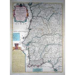
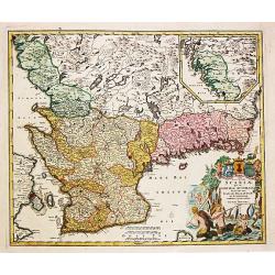
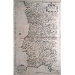
Le Royaume de Portugal divisé en cinq grandes Provinces...
Rare and large map of entire Portugal, extending from Vigo in the North to Cadiz in the South. Highly decorative map, superbly engraved, with a large title cartouche, a s...
Date: Paris, 1762
Selling price: ????
Please login to see price!
Sold in 2011
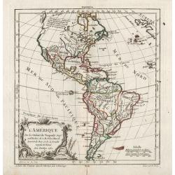
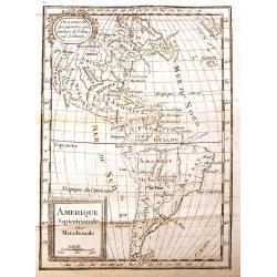
L'Amérique.
General map of America. From Gilles Robert de Vaugondy's Nouvel Atlas Portatif.
Date: Paris, 1762
Selling price: ????
Please login to see price!
Sold in 2012
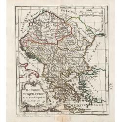
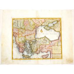
Hongrie, Turquie Europ?
General map of Greece. From Gilles Robert de Vaugondy's Nouvel Atlas Portatif.
Date: Paris, 1762
Selling price: ????
Please login to see price!
Sold in 2011
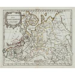
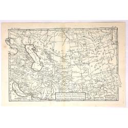
Partie Septentrionale de la Russie Européenne.
Map of the northern part of western Russia. From Gilles Robert de Vaugondy's Nouvel Atlas Portatif.
Date: Paris, 1762
Selling price: ????
Please login to see price!
Sold in 2011
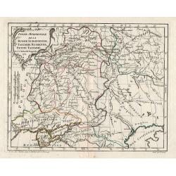
Partie Meridionale de la Russie Européenne, Tartarie Rusienne, Petite Tartarie.
Map of the southern part of western Russia. From Gilles Robert de Vaugondy's Nouvel Atlas Portatif.
Date: Paris, 1762
Selling price: ????
Please login to see price!
Sold in 2011
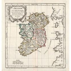
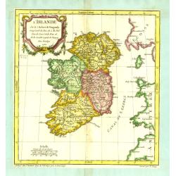
L\'Irlande.
General map of Ireland. From Gilles Robert de Vaugondy's Nouvel Atlas Portatif.
Date: Paris, 1762
Selling price: ????
Please login to see price!
Sold in 2012
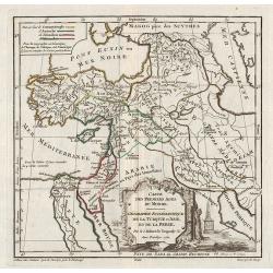
Carte des Premiers Ages du Monde. Géographie Ecclésiastique de la Turquie d'Asie, et de la Perse.
Historical map of Middle east. From Gilles Robert de Vaugondy's Nouvel Atlas Portatif.
Date: Paris, 1762
Selling price: ????
Please login to see price!
Sold in 2011
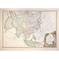
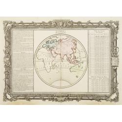
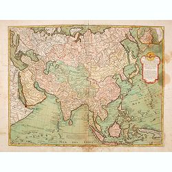
L'Asie, divisee en ses principaux etats par le Sr. Janvier, Geographe.
Detailed map of Asia from Janvier's Atlas Moderne. Includes a decorative cartouche that incorporates an incense pot with a pile of treasure. Engraved map. Boundaries ou...
Date: Paris, 1762
Selling price: ????
Please login to see price!
Sold in 2012
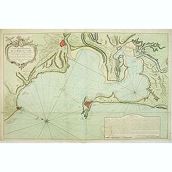
Carte Hydrographique de la Baye de Cadix : Dressée au Dépost des Cartes et Plans de la Marine pour le Service des Vaisseaux du Roy / Par ordre de M. le duc de Choiseul. . .
Scarce of Cadiz and surroundings prepared by Étienne-François de Choiseul (1719-1785).Jacques Nicolaas Bellin (1703-1772) was one of the most important and proficient ...
Date: Paris, 1762
Selling price: ????
Please login to see price!
Sold in 2017
Observations sur les Points Cardinaux. . .
Decorative world map illustrating the cardinal points on the two hemispheres. Left and right with lengthy text about the cardinal points as well as the lines and the circ...
Date: Paris, 1762
Selling price: ????
Please login to see price!
Sold in 2014
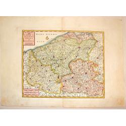
Nuova Carta delle Contee di Fiandra, Artois ed Hannonia.
Detailed copper engraved map featuring the Flanders region of Belgium. Two block type cartouches. Published by Giambattista Albrizzi (1698-1777) who was a Venetian publis...
Date: Venice from 1740-1762
Selling price: ????
Please login to see price!
Sold in 2016
Le Geographe Manuel, Contenant La Description de Tous les Pays du Monde.
Miniature Atlas in French featuring maps of The World, The Americas, Asia, Africa, Europe & France. Atlas is by Jean Joseph Georges Abbe d'Expilly who was a French di...
Date: Paris, 1762
Selling price: ????
Please login to see price!
Sold in 2013
Nuova Carta del Ducato di Brabante, Limburgo e della Gheldria Superiore.
Italian rendition of this detailed copper engraved map of the Brabant region of The Netherlands. Decorated with two block type cartouches, by Giambattista Albrizzi (1698-...
Date: Venice from 1740-1762
Selling price: ????
Please login to see price!
Sold in 2016
Nuovo Carta dei XIII Cantoni degli Svizzeri insieme coi loro Alleati e Sudditi.
Fine Copper Engraved map of Switzerland from "Atlante Novissimo che Contiene Tutte le Parti del Mondo" by Giambattista Albrizzi. Two block type cartouches. Giam...
Date: Venice, 1740-1762
Selling price: ????
Please login to see price!
Sold in 2016
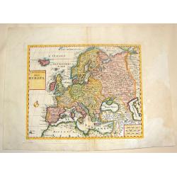
Carta Nuova dell Europa.
Fine colored copper engraved map of Europe based on Delisle's map. Two block style cartouches, by Albrizi after I. Tirion. Giambattista Albrizzi (1698-1777) was a Veneti...
Date: Venice from 1740-1762
Selling price: ????
Please login to see price!
Sold in 2016
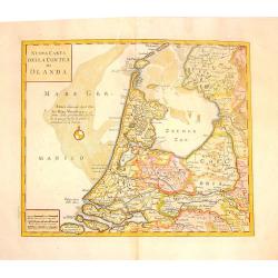
Nuova Carta della Contea de Olanda.
Fine copper engraved map of Holland. Two block cartouches. Giambattista Albrizzi (1698-1777) was a Venetian publisher and journalist. Among books published, was a monume...
Date: venice, 1740-1762
Selling price: ????
Please login to see price!
Sold in 2015
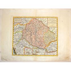
Regno di Ungheria e della Transilvania.
Fine copper-engraved map featuring Hungary and Transylvania (Romania). Embellished with block title & scale cartouches.Giambattista Albrizzi (1698-1777) was a Venetia...
Date: venice, 1740-1762
Selling price: ????
Please login to see price!
Sold in 2016
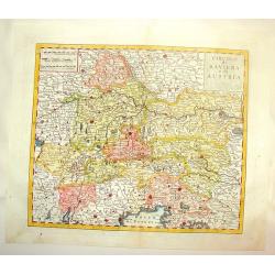
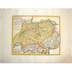
Circulo di Baviera e di Austria.
Fine, detailed, copper engraved map of Bavaria & Austria. Two block style cartouches, by Albrizi after I. Tirion.Giambattista Albrizzi (1698-1777) was a Venetian publ...
Date: Venice, from 1740-1762
Selling price: ????
Please login to see price!
Sold in 2016
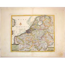
Carta Nuova ed Accurata delle XVII Provincie de 'Paesi Bassi.
Fine colored copper engraved map of Belgium & The Netherlands. Two block cartouches, by Giambattista Albrizzi (1698-1777) who was a Venetian publisher and journalist....
Date: Venice from 1740-1762
Selling price: ????
Please login to see price!
Sold in 2016
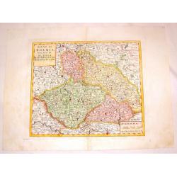
Regno di Boemia Ducato di Slesia, Marchesato de moravia, c Lusazia.
Fine copper engraved map os Czechoslovachia, Poland and Hungary. Two block type cartouches.Giambattista Albrizzi (1698-1777) was a Venetian publisher and journalist. Amo...
Date: Venice from 1740-1762
Selling price: ????
Please login to see price!
Sold in 2016
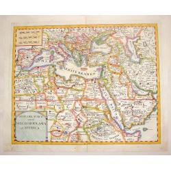
Stati del Turco Situati Nell Europa, Asia ed Affrica.
Fine copperplate map of Europe with Northern Africa and Western Asia. Includes two block-style cartouches.Giambattista Albrizzi (1698-1777) was a Venetian publisher and j...
Date: Venice, 1740-1762
Selling price: ????
Please login to see price!
Sold in 2016
Nuova Carta del Europa Turchesca.
Nice Italian version of Tirion's detailed map of the Black Sea, Balkans, Cyprus and Asia Minor including Turkey. Includes a block cartouche. Published by Albrizzi. Giamb...
Date: venice, 1740-1762
Selling price: ????
Please login to see price!
Sold in 2015
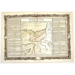
Royaume de Pont - Depuis L'An 3689 Jusqu'a L'an 3855.
Fine copper engraved map of a portion of the ancient Holy Land. It is decorated with a floral frame that interestingly, was printed separately from the map. It is from &q...
Date: Paris, 1762
Selling price: ????
Please login to see price!
Sold in 2015
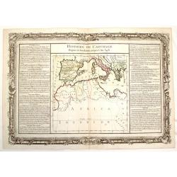
Histoire de Carthage - Depuis sa Foundation Jusqu'a L'An 3481.
Fine copper engraved map of a portion of ancient Carthage, around the Mediterranean Sea. It is decorated with a floral frame that interestingly, was printed separately fr...
Date: Paris, 1762
Selling price: ????
Please login to see price!
Sold in 2015
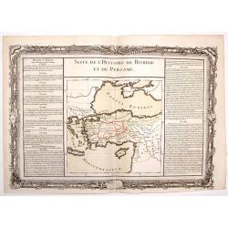
Suite de L'Histoire de Bithinie et de Pergame.
Striking map of the ancient Holy Land featuring the territory between Macedonia and Armenia north of the Mediterranean Sea. The text in the sides of the map describe the ...
Date: Paris, 1762
Selling price: ????
Please login to see price!
Sold in 2015
Suite de L'Histore d'Athens Depuis L'An 3573 Jusqu'a L'An 3581.
Striking map of ancient Athens featuring the territory including current Italy and Greece, north of the Mediterranean Sea. The text in the sides of the map describe the h...
Date: Paris, 1762
Selling price: ????
Please login to see price!
Sold in 2015
![[Two Title pages from] Great Britains Coasting Pilot being A New Survey of the Sea Coast.](/uploads/cache/93283-250x250.jpg)
[Two Title pages from] Great Britains Coasting Pilot being A New Survey of the Sea Coast.
Two Title pages from "Great Britains Coasting Pilot being A New Survey of the Sea Coast" Capt. Greenvile Collins 1762 – 1772 edition.Uncommon and beautifully ...
Date: London, 1762
Selling price: ????
Please login to see price!
Sold in 2014
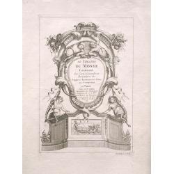
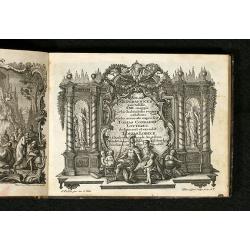
(Title page) Le Theatre Du Monde
Decorative Title Page from R. Julien's Atlas "Le Theatre Du Monde", engraved by Poilly.
Date: Pais 1762
Selling price: ????
Please login to see price!
Sold in 2014
Le Portugal et ses Frontieres avec l'Espagne. . .
Impressive large-scale map of Portugal with the border areas of Spain, published by the Depot de la Marine. Highly detailed filled with information on the topography, fo...
Date: Paris, 1762
Selling price: ????
Please login to see price!
Sold in 2014
Carte d'Asie..
Detailed map of Asia with inset map of Siberia and the east coast of America. The map is of interest for the use of East Sea, the sea between Korea and Japan, here called...
Date: Paris, 1762
Selling price: ????
Please login to see price!
Sold in 2014
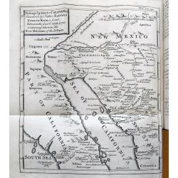
Travels of the Jesuits...(with Kino map of California).
Famous account by John Lockman, illustrated with five fold-out maps and 1 fold-out plate. With the important "Kino" map of California (Passage by land to Califo...
Date: London, 1762
Selling price: ????
Please login to see price!
Sold in 2015
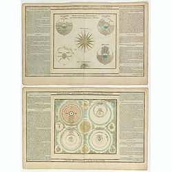
Géographie Moderne, Historique et Politique (Lot of 2 prints)
Two decorative celestial chart showing the systems according to Ptolemy, Tycho Brahe, Copernicus and Descartes. The second print is entitled "Démonstrations géomé...
Date: Paris, 1762
Selling price: ????
Please login to see price!
Sold in 2015
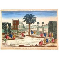
Vue Perspective d'un Jeu de Bague en Espagne.
Optical vue of children playing in Spain. In the eighteenth and nineteenth centuries there were many popular specialty establishments in Paris, Augsburg and London, that ...
Date: Paris, 1762
Selling price: ????
Please login to see price!
Sold in 2019
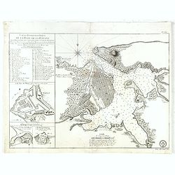
Carte Hydrographique de la Baye de la Havane.. N° 69.
A well engraved and highly detailed of the walled city of Havana and its harbor features inset plans of three forts (La Punta, El Morro, and La Real Fuerza) as well as a...
Date: Paris, 1762
Selling price: ????
Please login to see price!
Sold in 2016
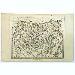
Siberie ou Russie Asiatique, Tartarie Chinoise, pays des Eluts et Isles du Japon.
A detailed map of Siberia and Chinese Tartary. Map includes Corea and Japan to the east. Gilles Robert de Vaugondy (1688–1766), also known as Le Sieur or Monsieur Rober...
Date: Paris, c 1762
Selling price: ????
Please login to see price!
Sold in 2021
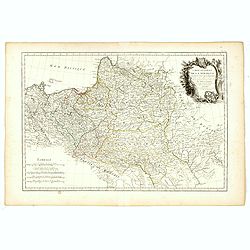
Carte Générale de la Pologne.
Detailed map of Poland, prepared by Rizzi Zanoni from his "Atlas moderne ou collection de cartes...", map N° 19.
Date: Paris, 1762
Selling price: ????
Please login to see price!
Sold in 2023
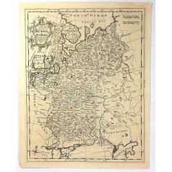
A New and Accurate Map of Russia in Europe
An antique copper engraved Map by Thomas Kichin, published in 1762 in London from "A New System of Geography..." by Anton Friedrich Busching. Decorated with a r...
Date: London, 1762
Selling price: ????
Please login to see price!
Sold in 2016
Cumberland, Drawn from the Best Surveys, Maps & Charts
An attractive and finely engraved 18th century map of Cumberland, by Thomas Kitchin, which was published in Henry Boswell's 'Antiquities of England & Wales'. It featu...
Date: London, 1762
Selling price: ????
Please login to see price!
Sold in 2016
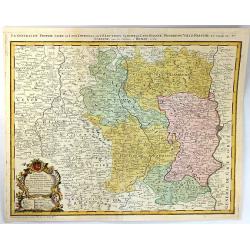
Propriae Lugudunensis Generalitatis Mappa Chorographica
A detailed map of the Beaujolais region, including the cities of Lyon, Clermont Ferrand, Roanne, Saint Etienne, and Vienne. Fully engraved with mountains, lakes, rivers, ...
Date: Nuremberg, 1762
Selling price: ????
Please login to see price!
Sold in 2016
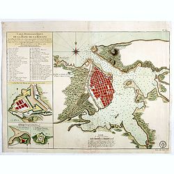
Carte Hydrographique de la Baye de la Havane.. N° 69.
A well engraved and highly detailed of the walled city of Havana and its harbor features inset plans of three forts (La Punta, El Morro, and La Real Fuerza) as well as a...
Date: Paris, 1762
Selling price: ????
Please login to see price!
Sold in 2018
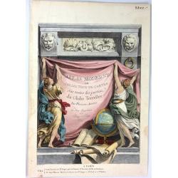
(Title page) Atlas Moderne ou Collection de Cartes Sur Toutes les Partie du Globe Terrestre
A fine title page engraving from Janvier's "ATLAS MODERNE". It was engraved by Monnet at Chez Lattre in 1762 in Paris.It features two female figure hanging a dr...
Date: Paris, 1762
Selling price: ????
Please login to see price!
Sold in 2017
Carte de la Perse, de la Georgie, et de la Tartarie Independante.
Detailed map centered on "Tartarie Independante" the region east of the Caspian Sea with Kazachstan, Oezbekistan and Turkmenistan and also showing Georgia and I...
Date: Paris , 1762
Selling price: ????
Please login to see price!
Sold in 2017
Plan of the Town and Citadel of St. Martin in the Isle of Re.
This print depicts the town and citadel of St. Martin.
Date: London, 1762
Selling price: ????
Please login to see price!
Sold in 2017
The Large English Atlas, or, a New Set of Maps of All the Counties of England and Wales.
FIRST EDITION. "The Large English Atlas" is the most important eighteenth-century English atlas to be published before the appearance of John Cary's new English...
Date: Londen, T. Bowles, John Bowles and Robert Sayer, [n.d.] ca. 1762
Selling price: ????
Please login to see price!
Sold in 2017
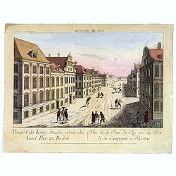
Vue de la Rue du Roi, vers la Porte de la Campagne a Boston.
A vue d'optique of the city of Boston.
Date: Augsburg, 1762
Selling price: ????
Please login to see price!
Sold in 2018
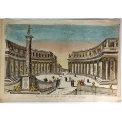
Vue Perspective du Superbe Palais d'Aexandre en Egypte.
A fine hand colored 'vue perspective' of the Hernandre Palais in Egypt. It was produced and hand colorued in Paris at Chez Mondare in 1762.Vues d'optique, was a special t...
Date: Paris, 1762
Selling price: ????
Please login to see price!
Sold in 2019
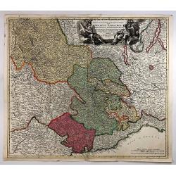
Regiae Celsitudinis Sabaudicae Status in quo ducatus Sabaudiae Principatus Dedemontium. . .
A highly detailed map of the Piedmont region in Northern Italy. The major cities of Torino, Milan, and Genoa and Geneva as well as Switzerland are shown. Cartouche includ...
Date: Nuremberg, 1762
Selling price: ????
Please login to see price!
Sold in 2018
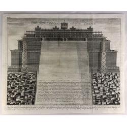
The Prospect of Ye East Side of the Temple.
A fine copper engraved religious print from a Bible in 1762. It features the east side view of the Temple of Solomon. “And the word of the Lord came to Solomon saying ...
Date: London, 1762
Selling price: ????
Please login to see price!
Sold in 2019
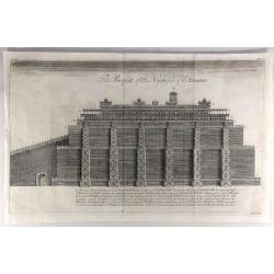
The Prospect of the North Side of the Temple.
A fine copper engraved religious print from a Bible in 1762. It features the north side view of the temple of Solomon. Each of the different levels of the temple are lab...
Date: London, 1762
Selling price: ????
Please login to see price!
Sold in 2019
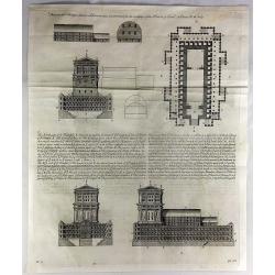
These are the Things Wherin Solomon Was Instructed for the Building of the House of God, II Chronicles, Chapter III, Verse 3.
A fine copper-engraved religious print from a Bible in 1762. It features pictures of all sides of the temple with labels and explanations in the key at the center.
Date: London, 1762
Selling price: ????
Please login to see price!
Sold in 2018
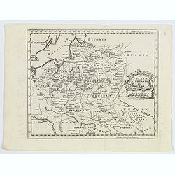
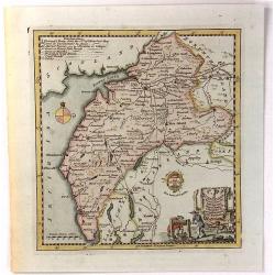
Poland Lithuania and Prussia.
A delightful, detailed map of the Poland and Lithuania, showing numerous geo-political subdivsions, including Courland, Samgotia, Warsovia, Great Poland, Polesi, Volhinia...
Date: London, 1762
Selling price: ????
Please login to see price!
Sold in 2019
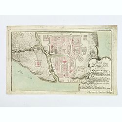
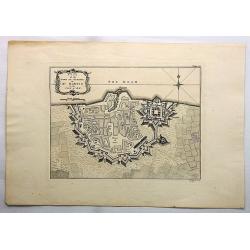
Plan der Stadt und Festung Madrass in Ost-Indien.
Scarce plan of Madras, taken from a collection of battle and siege plans that relate to the 'Seven Years War'. This detailed plan shows off the British Fortress of Madras...
Date: Nuremberg, ca 1762
Selling price: ????
Please login to see price!
Sold in 2018
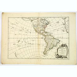
L'Amerique divisée Pars Grands Etats.
Engraved by Lattré. This map is most notable for it's depiction of Mer ou Baye de L'Ouest or Sea of the West. A great sea, possibly the size of the Mediterranean, to flo...
Date: Paris, 1762
Selling price: ????
Please login to see price!
Sold in 2019