Browse Listings
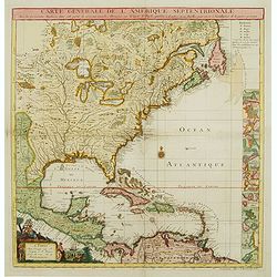
![L' AMERIQUE SEPTENTRIONALE divisee en les principaux ETATS.[Great western sea, First State]](/uploads/cache/82867-250x250.jpg)
L' AMERIQUE SEPTENTRIONALE divisee en les principaux ETATS.[Great western sea, First State]
First state for this very important map. Engraved by Lattré. This map is most notable for it's depiction of Mer de L'Quest or Sea of the West, near modern-day Seattle. A...
Date: Paris, 1762
Selling price: ????
Please login to see price!
Sold in 2019
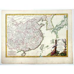
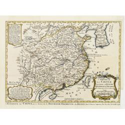
L'EMPIRE DE LA CHINE d'après l'Atlas Chinois avec les Isles du Japon.
A detailed map of China, Korea and the Islands of Japan, showing the Provinces, towns, mountains, rivers, lakes, islands, published in Paris by Jean Lattre. The map is dr...
Date: Paris, 1762
Selling price: ????
Please login to see price!
Sold in 2019
![L'AMERIQUE divisee par Grands Etats.[Bay of the West]](/uploads/cache/83601-250x250.jpg)
L'AMERIQUE divisee par Grands Etats.[Bay of the West]
First state of Janvier's map of America, published in Paris in 1762. It shows a gloriously oversized mythical Bay of the West, unusual Alaskan Archipelago (again complete...
Date: Paris, 1762
Selling price: ????
Please login to see price!
Sold in 2020
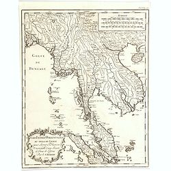
Les Indies Orientales au-dela Gange. . .
A nice map of Indo-China, taking in Burma, Thailand, Laos, Vietnam, Malaysia, Sumatra and Singapore. With good map detail, covering rivers, mountains, small islands, and ...
Date: Paris, 1762
Selling price: ????
Please login to see price!
Sold in 2020
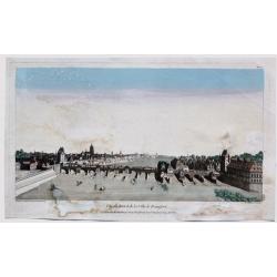
Vue du Pont et de la Ville de Francfort.
Fine 1762 Chereau & Wichnyther's optical view of Frankfurt , Germany. Several vessels are in the river.In the eighteenth and nineteenth centuries there were many popu...
Date: Paris, 1762
Selling price: ????
Please login to see price!
Sold in 2023
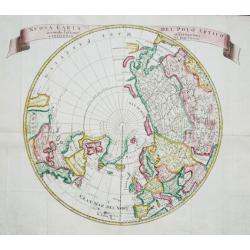
Nuova Carta del Polo Arctico secondo l'ultime offervazioni.
A lovely map centered on the North Pole and the surrounding countries. From the Italian edition of Thomas Salmon's 'Modern History: or, the present state of all Nations. ...
Date: Venice, 1740-1762
Selling price: ????
Please login to see price!
Sold in 2020
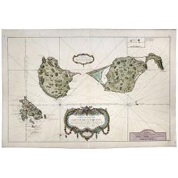
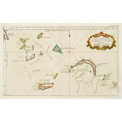
![[Lot of 11 maps and views of the Falkland islands and the Argentinian part of Terra del Fuega. ]](/uploads/cache/20422-(2)-250x250.jpg)
[Lot of 11 maps and views of the Falkland islands and the Argentinian part of Terra del Fuega. ]
Rigobert Bonne (1727-1795), French cartographer. His maps are found in a.o. Atlas Moderne (1762), Raynal's Histoire Philos. du Commerce des Indes (1774) and Atlas Encyclo...
Date: Paris, 1762
Selling price: ????
Please login to see price!
Sold in 2022
![[A Lot of 2 maps Europe]](/uploads/cache/IMG_0092-250x250.jpg)
[A Lot of 2 maps Europe]
Claude Buy de Mornas (d. 1783), géographe du roi (1764). Atlas Méthodique et Elémentaire de Géographie et d' Histoire, 1761, Atlas Historique et Géographique, 1762. ...
Date: Paris, 1762
Selling price: ????
Please login to see price!
Sold in 2025
![[ Lot of 6 world and thematic maps ] Climats d'Heures et de Mois.](/uploads/cache/IMG_0772-250x250.jpg)
[ Lot of 6 world and thematic maps ] Climats d'Heures et de Mois.
A map of the Ancient World with the climate circles. On both sides a description text. All within an elaborate and very decorative border. A very fine item.Claude Buy...
Date: Paris, 1762
Selling price: ????
Please login to see price!
Sold in 2023
Carte des Isles de Saint Pierre et Miquelon. . .
A large scale sea-chart of the French overseas territory Saint Pierre and Miquelon near Newfoundland. A very detailed chart with topographical information of the islands,...
Date: Paris, 1763
Selling price: ????
Please login to see price!
Sold in 2020
Saint Pierre, Plan de l'Ile de .., au Sud de Terre-Neuve.
A highly detailed map based on a survey by Fortin, and published by the 'Dépôt Général de la Marine' (the maritime chart printing office of the French government) in ...
Date: Paris, 1763
Selling price: ????
Please login to see price!
Sold in 2022
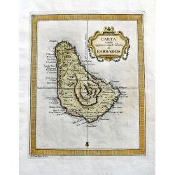
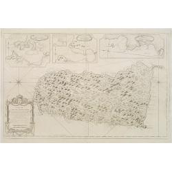
Carta esatta rappresentante l'isola di Barbados.
A fine map of Barbados published in the "Gazzetiere Americano". Engraved by V. Rossi. In nice and decorative colors, and in good condition!
Date: Livorno, 1763
Selling price: ????
Please login to see price!
Sold in 2020
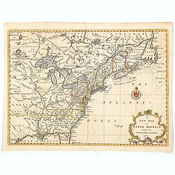
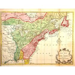
A New Map of North America from the Latest Discoveries.
A nice detailed map of the British Colonies in North America, published at the end of the French & Indian War. The claims of the Carolinas, Virginia and New England n...
Date: London, 1763
Selling price: ????
Please login to see price!
Sold in 2020
Carte de la guyans Francois et l'isle de Cayenne. . .
A detailed and well engraved sea chart of French Guiana and the island of Cayenne, via a large inset. The map was published in 1763 by Bellin (1703-72), a high output car...
Date: Paris, 1763
Selling price: ????
Please login to see price!
Sold in 2020
Plan de L'Ile de Saint Pierre au Sud de Terre-Neuve Levé en 1793 par le Sr. Fortin Ingénieur Géographe, et Publié au Dépôt Général des Cartes . . .
A very large, extremely decorative, detailed map of the island of St. Pierre, produced for the French 'Depot de la Marine'. kindly note the nice original colors.
Date: Paris, 1763
Selling price: ????
Please login to see price!
Sold in 2021
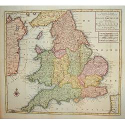
Nieuwe Kaart van't Zuider Gedeetle van Groot Britannie.
A very attractive and detailed map of England and Wales. This work includes topography along with principal roads and cities. Portions of Scotland, Ireland and France are...
Date: Amsterdam, 1763
Selling price: ????
Please login to see price!
Sold in 2009
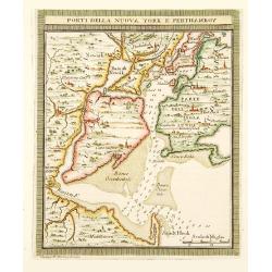
Porti della Nuova York e Perthaboy.
"From ""Il Gazettiere Americano"". Engraved by Guseppe M. Terreni. Interesting chart of Manhattan, part of Long Island, New Jersey. Names are in ...
Date: Livorno 1763
Selling price: ????
Please login to see price!
Sold
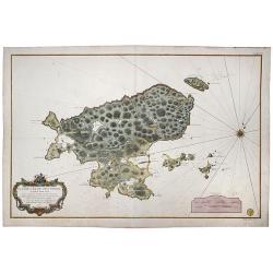
Carte des Isles Sittuees au Nord de St. Domingue..
Decorative map of the islands north of S.Domingo. Showing soundings and much detail.
Date: Paris 1763
Selling price: ????
Please login to see price!
Sold
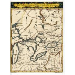
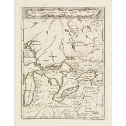
CARTA RAPPRESENTANTE I CINQUE LAGHI DEL CANADA
Rare and important Italian map showing the area of the Great Lakes. Published in "Il Gazzettiere Americano" 1763. Very detailed map of the area with many place...
Date: Livorno, 1763
Selling price: ????
Please login to see price!
Sold
Carte Générale de l' Amérique Séptentrionale ..
Uncommon 3rd version of Le Rouge's Popple key map by Crepy. This state 3 is a variant of state 2 (from the same plate) except: title at top now states: CARTE GÉNÉRALE D...
Date: Paris, ca. 1763
Selling price: ????
Please login to see price!
Sold
Carte de l'Isle de Sainte Lucie..
Attractive double page chart of St. Lucia with inset plans ('Port du Carenage', Cul de sac des Roseaux' and 'Mouillages du Grand Islet et du Choc', illustrating some deta...
Date: Paris 1763
Selling price: ????
Please login to see price!
Sold in 2008
Carta Rappresentante I cinque Laghi del Canada.
Highly detailed map of the Great Lakes and contiguous regions, which appeared in Masi's "Il Gazzettiere Americano." Engraved by A.Scacciati.The map's nomenclatu...
Date: Livorno 1763
Selling price: ????
Please login to see price!
Sold
L'Empire de La Chine pour servir a L'Histoire Generale des Voyages..
Detailed colored map of China and Korea in the Northeast with the Chinese Sea.The map is high accurate and naming many cities, lakes, rivers and mountains. Major towns ar...
Date: Amsterdam 1763
Selling price: ????
Please login to see price!
Sold
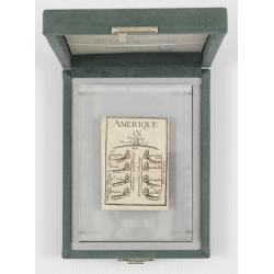
Court card with The nine of Amerique. (Letterweight)
A playing card with a map including detail with "Nouvelle York" and Nassau in the top: St.Augustine in Florida, and Coca, St.Asee, Panuco, Guadalajara, La Guate...
Date: Paris, 1763
Selling price: ????
Please login to see price!
Sold in 2012
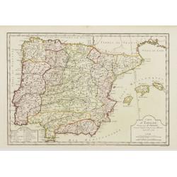
Carte d'Espagne, Dirigée par Mr. Philippe..
Detailed map of the Hibernian Peninsula and Baleares islands, showing a short legend in the lower left corner.
Date: Paris, 1763
Selling price: ????
Please login to see price!
Sold
Piano della Citta di S.Domingo.
An Italian edition of the Jeffery's plan of Santo Domingo city from the Gazzettiere Americano.
Date: Livorno, 1763
Selling price: ????
Please login to see price!
Sold in 2008
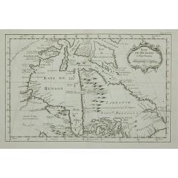
Baye de Hudson et Pays Voisins.
This chart shows the territories of Hudson Bay.The only issue of this version of Bellin's map, slightly larger than the common version. Depths shown by soundings.From Bel...
Date: Paris, 1763
Selling price: ????
Please login to see price!
Sold in 2011
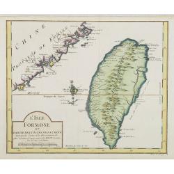
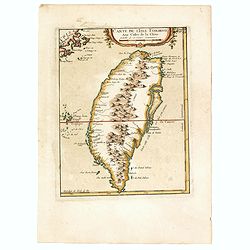
L' Isle Formose et parties des Costes de la Chine. . .
This well-known map of Taiwan is prepared by Jacques Nicolas Bellin and was based on Jesuit information. The text along the island's east-coast claims: Of this coast litt...
Date: Paris, 1763
Selling price: ????
Please login to see price!
Sold in 2014
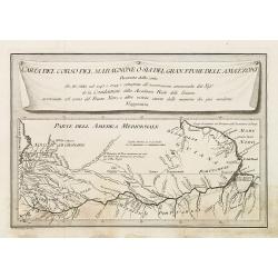
Carta del Corso del maragnone o sia del gran flume dell' Amazonni. . .
Uncommon map of the Amazon by Veremondo Rossi after the important map of Charles Marie de la Condamine (1701-1774) who made a map of the Amazon river in 1745.
Date: c. 1763
Selling price: ????
Please login to see price!
Sold in 2010
Mapa de La Provincia, de Madrid. . .
Detailed of the region surrounding the city of Madrid, Spain, by Thomas Lopez. Shows the rivers, forests and mountains of the region.
Date: Madrid, 1763
Selling price: ????
Please login to see price!
Sold in 2010
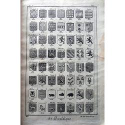
Blason ou Art Héraldique.
Interesting folio sized work with 26 single page, and one large folding copper engravings. Illustrates numerous heraldic figures, coat of arms, amours, a genealogical tre...
Date: Paris, c1763
Selling price: ????
Please login to see price!
Sold in 2019
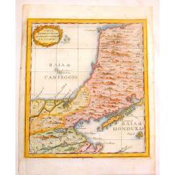
Carta Rappresentante La Baladi Campeggio E \'L Jucatan.
Copper engraved map of the isthmus between the Bays of Honduras & Campeche near Belize and Yucatan. This area had been considered as a possible transoceanic canal rou...
Date: Livorno, 1763
Selling price: ????
Please login to see price!
Sold in 2013
Carta Rappresente Una Parte dlla Baja D'Hudson.
Fine copperplate engraved map of the northern portion of Hudson's Bay in Canada. It is from Masi's "Il Gazzettiere Americano". There is a decorative cartouche.
Date: Livorno, 1763
Selling price: ????
Please login to see price!
Sold in 2015
A New map of North America from the latest discoveries 1763.
From London magazine, January 1763.
Date: London, c.1763
Selling price: ????
Please login to see price!
Sold in 2013
The Environs of London Reduced from an Actual Survey in 16 Sheets, by the Late John Rocque, topographer to His Majesty with New Improvements to the Year 1763. . .
A fine map of greater London being a reduced version of John Rocque's survey of London in 16 sheets. The map bears the name of Rocque's widow, Mary Ann, who continued his...
Date: London, 1763
Selling price: ????
Please login to see price!
Sold in 2013
Carte des isles de St Pierre et de Miquelon...
Large scale sea-chart of the French overseas terrirtory Saint Pierre and Miquelon near Newfoundland.Very detailed with topographical information of the islands, also show...
Date: Paris, 1763
Selling price: ????
Please login to see price!
Sold in 2014
Plan de l´Ile de Saint Pierre au Sud de Terre-Neuve...
Large sea chart of Saint-Pierre. Highly detailed showing small islands, reefs, depth soundings, exact topographical details. Decorated with a large title cartouche and a ...
Date: Paris, 1763
Selling price: ????
Please login to see price!
Sold in 2014
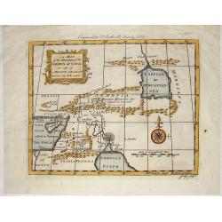
A Map of the Situation of the Garden of Eden as Also of Mouth Ararat.
This interesting map shows Gordion Mountains where the ark is supposed to have rested. It was engraved by J. Flyn for Dr. Southwell's Family Bible.
Date: London, 1763
Selling price: ????
Please login to see price!
Sold in 2014
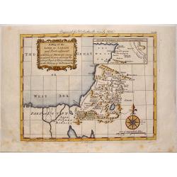
A Map of the Land of Canaan and Parts Adjacent.
"At the time of Abraham's coming to sojourn the rein, showing the several people & places mentioned in the history of the Patriarchs".Engraved by G. Rollos ...
Date: London, 1763
Selling price: ????
Please login to see price!
Sold in 2014
![Histoire universelle depuis le commmencement du monde jusqu'a present. . . Tome Vingtieme. Contenant [...] l'histoire [...] la Chine [...] la Corée [...] du Japon [...] & des [...] Indes Orientales](/uploads/cache/35153-250x250.jpg)
Histoire universelle depuis le commmencement du monde jusqu'a present. . . Tome Vingtieme. Contenant [...] l'histoire [...] la Chine [...] la Corée [...] du Japon [...] & des [...] Indes Orientales
Volume 20 of this informative publication with a description of China and Korea and the discoveries, conquests, and settlements by the Portuguese, Spaniards, English, and...
Date: Amsterdam, Leipzig, 1763
Selling price: ????
Please login to see price!
Sold in 2014
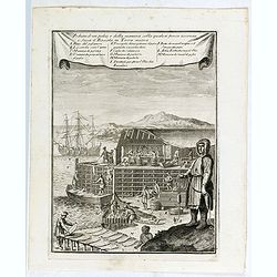
Veduta d'un palco, e della maniera colla quale si pesca acconcia e secca il Baccala in Terra nuova.
This is a view of a cod or fish drying station (stage) in New France or Newfoundland. Includes men fishing for cod, unloading catch from a boat, processing and fileting f...
Date: Livorno, 1763
Selling price: ????
Please login to see price!
Sold in 2015
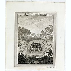
La caccia dei castori.
Beaver lodge. Includes native Americans hunting beavers using guns or muskets, bows and arrows, waterfall. In the background, hunters skin the beavers.From "Il Gazze...
Date: Livorno, 1763
Selling price: ????
Please login to see price!
Sold in 2015
Figura di un Forte Indiano.
View of a native American settlement or fort. Includes dwellings, domestic animals such as oxen and donkeys, palisades, guns or muskets, and council fire. From "Il G...
Date: Livorno, 1763
Selling price: ????
Please login to see price!
Sold in 2015
Les Revolutions de l'Univers.
First edition of this historical atlas presenting the political devisions of Eurasia from the dispersion of the Childern of Noah until the reunion of Lorraine to France....
Date: Paris, Lattré, M CC. LXIII. [1763
Selling price: ????
Please login to see price!
Sold in 2015
Carte de L'Isle Formose aux Costes de la Chine.
This well-known map of Taiwan is based on Jesuit information. One of the first maps to give the name Taiwan to island of Formosa. The mountains in the center have the lar...
Date: Paris, 1763
Selling price: ????
Please login to see price!
Sold in 2021
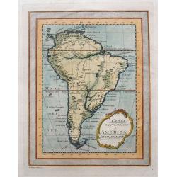
Carta rappresentante l'America Meridionale.
Rare map of South America, published in 1763 (Gazettiere Americano?). Indicates major cities, rivers, and mountains. With a frame style border, nice hand coloring, and a ...
Date: Livorno, 1763
Selling price: ????
Please login to see price!
Sold in 2015
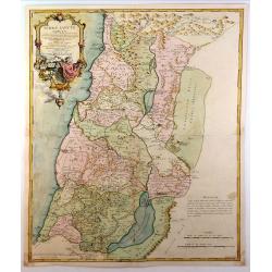
Terrae Sanctae Tabula e Scripturae Sacrae, Flavii Josephi ....
A large, striking example of De L'Isle's 1762 decorative map of the Holy Land, including Israel and Palestine. Printed in two sheets, it covers the region from Gaza and t...
Date: Paris, 1763
Selling price: ????
Please login to see price!
Sold in 2015
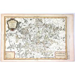
Chorographie du Cercle de Franconie D'Apres Valck et Hubner.....
Fine detailed map of the Franconia region of Germany. Franconia (in German Franken) is a geographical and historical region of south-central Germany. Since 1815 it was a...
Date: Paris, 1763
Selling price: ????
Please login to see price!
Sold in 2018
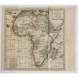
Kaart van Afrika door den Heer D'Anville, Te Amsterdam/ By Isaak Tirion, 1763.
A copper engraved map, overall size 37 x 42 cm.Very detailed map of the African continent by Tiron, after D'Anville, from:' Hedendaagsche Historie of Tegenwoordige Staat ...
Date: Amsterdam, 1763
Selling price: ????
Please login to see price!
Sold in 2016
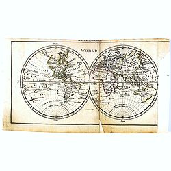
(Mappe monde) World.
Uncommon miniature world map, engraved by Thomas Kitching for "A New General and Universal Atlas Containing Forty five Maps by Andrew Dury".This miniature atlas...
Date: London, 1761-1763
Selling price: ????
Please login to see price!
Sold in 2016
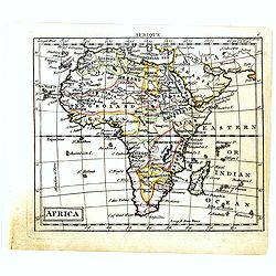
Africa.
Uncommon miniature map of Africa, engraved by Thomas Kitching for "A New General and Universal Atlas Containing Forty five Maps by Andrew Dury".This miniature a...
Date: London, 1761-1763
Selling price: ????
Please login to see price!
Sold in 2016
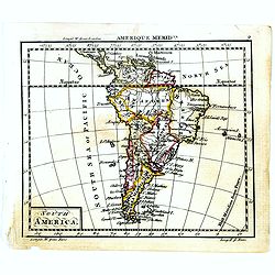
South America.
Uncommon miniature map of South America, engraved by Thomas Kitching for "A New General and Universal Atlas Containing Forty five Maps by Andrew Dury".This mini...
Date: London, 1761-1763
Selling price: ????
Please login to see price!
Sold in 2018
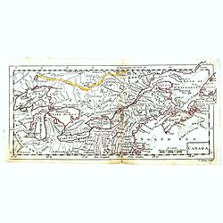
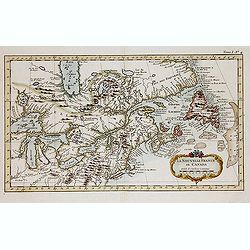
Canada.
Uncommon miniature map of Eastern Canada, engraved by Thomas Kitching for "A New General and Universal Atlas Containing Forty five Maps by Andrew Dury".This min...
Date: London, 1761-1763
Selling price: ????
Please login to see price!
Sold in 2018
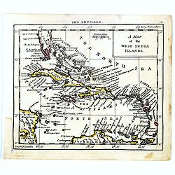
A map of West India Islands.
Uncommon miniature map of Caribbean with the southern tip of Florida, engraved by Thomas Kitching for "A New General and Universal Atlas Containing Forty five Maps b...
Date: London, 1761-1763
Selling price: ????
Please login to see price!
Sold in 2017
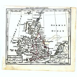
Great Britain and Ireland.
Uncommon miniature map of Great Britain and Ireland, engraved by Thomas Kitching for "A New General and Universal Atlas Containing Forty five Maps by Andrew Dury&quo...
Date: London, 1761-1763
Selling price: ????
Please login to see price!
Sold in 2016
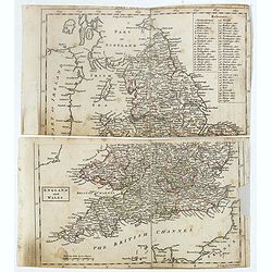
England and Wales.
Uncommon miniature map in two sheets of England and Wales engraved by Thomas Kitching for "A New General and Universal Atlas Containing Forty five Maps by Andrew Dur...
Date: London, 1761-1763
Selling price: ????
Please login to see price!
Sold
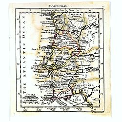
Spain and Portugal.
Uncommon miniature map of Portugal, engraved by J. Gibson for "A New General and Universal Atlas Containing Forty five Maps by Andrew Dury".This miniature atlas...
Date: London, 1761-1763
Selling price: ????
Please login to see price!
Sold in 2019
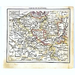
Flanders and the low Countries.
Uncommon miniature map of Belgium, engraved by Thomas Kitching for "A New General and Universal Atlas Containing Forty-five Maps by Andrew Dury." This miniature...
Date: London, 1761-1763
Selling price: ????
Please login to see price!
Sold in 2017
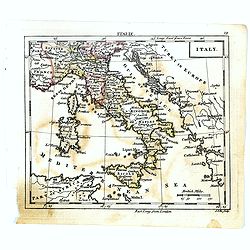
Italy.
Uncommon miniature map of Italy, engraved by J.Ellis for "A New General and Universal Atlas Containing Forty five Maps by Andrew Dury".This miniature atlas publ...
Date: London, 1761-1763
Selling price: ????
Please login to see price!
Sold in 2022
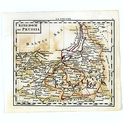
Kingdom of Prussia.
Uncommon miniature map of Prussia in Northern part of present-day Poland, engraved by Thomas Kitching for "A New General and Universal Atlas Containing Forty five Ma...
Date: London, 1761-1763
Selling price: ????
Please login to see price!
Sold in 2020
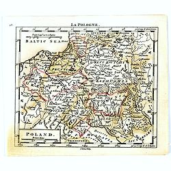
Poland.
Uncommon miniature map of Poland, engraved by Thomas Kitching for "A New General and Universal Atlas Containing Forty five Maps by Andrew Dury".This miniature a...
Date: London, 1761-1763
Selling price: ????
Please login to see price!
Sold in 2020
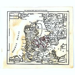
Denmark.
Uncommon miniature map of Denmark, engraved by Thomas Kitching for "A New General and Universal Atlas Containing Forty five Maps by Andrew Dury".This miniature ...
Date: London, 1761-1763
Selling price: ????
Please login to see price!
Sold in 2020
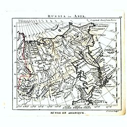
Russia in Asia.
Uncommon miniature map of Siberia, Kamchatka and Hokkaido. The map is of interest for the use of "Little East Sea" for the sea between Japan and Korea.Engraved ...
Date: London, 1761-1763
Selling price: ????
Please login to see price!
Sold
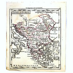
Turky in Europe.
Uncommon miniature map of Greece with the western most coast of Turkey, engraved by Thomas Kitching for "A New General and Universal Atlas Containing Forty five Maps...
Date: London, 1761-1763
Selling price: ????
Please login to see price!
Sold in 2017
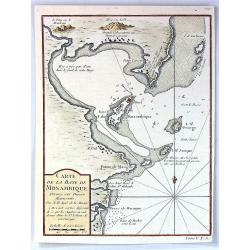
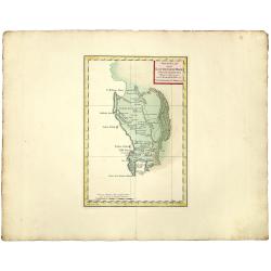
Carte de la Baye de Mosambique, Dressee sur Divers Manuscrits
A fine map of the Bay of Mozambique by Belling in Paris in 1763.Jaques Nicolas Bellin (1702-1772) was the most important French hydrographer of the 18th century. Some of ...
Date: Paris, 1763
Selling price: ????
Please login to see price!
Sold in 2016
Carta rappresentante una parte dlla Baja D'Hudson e le Regioni a Maestro Dell'America Settentrle.
A fine map the northwest corner of Hudson Bay from Masi's "Il Gazzettiere Americano." Published by Gio. Tommaso Masi.
Date: Livorno, 1763
Selling price: ????
Please login to see price!
Sold in 2018
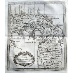
Carta Rappresentante l'Istmo di Darien o'sia di Panama.
A charming map of Panama from Coltellinis Il Gazzettiere Americano. With several town named such as Porto Bello, Panama, Crux di Juan, and Nuova Edinburg. Includes also ...
Date: Livorno, 1763
Selling price: ????
Please login to see price!
Sold in 2017
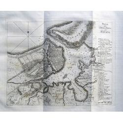
Piano della Città e Porto dell' Havana.
An interesting map of Havanna, with its harbour, drawn by Giuseppe Pazzi and engraved by Violanta Vanni for Coltellinis Il Gazzettiere Americano.With numerous depth sound...
Date: Livorno, 1763
Selling price: ????
Please login to see price!
Sold in 2017
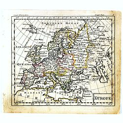
Europe.
Uncommon miniature map of Europe, engraved by Thomas Kitchin for "A New General and Universal Atlas Containing Forty-five Maps by Andrew Dury." This miniature a...
Date: London, 1761-1763
Selling price: ????
Please login to see price!
Sold in 2019

Holmens Kirke.
A fantastic and rare view of the Holmens Kirke (Church of Holmen) in Copenhagen in Denmark. With the Holmens Kanal, several ships, people, and a horse carriage. From the ...
Date: Copenhagen, 1763
Selling price: ????
Please login to see price!
Sold in 2018

Bar: Dehnsche Palais.
A fine view of the Palais, including people and horse carriages in the foreground.From the rare "Danske Atlas", the first and only edition of the monumental atl...
Date: Copenhagen, 1763
Selling price: ????
Please login to see price!
Sold in 2018
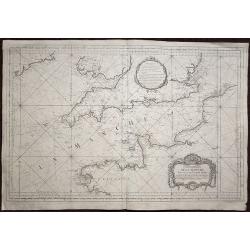
Carte de la Manche réduite Pour servir aux Vaisseaux du Roy.
A highly detailed sea chart of the English channel with accurate representation of the coasts of England and France. The map extends north to Ireland, in the east to Oste...
Date: Paris, 1763
Selling price: ????
Please login to see price!
Sold in 2020
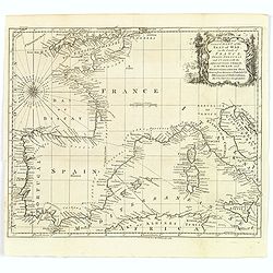
A New and Correct Chart of the Seat of War on the Coasts of France, Spain, Portugal and Italy. . .
A map showing the southern coast of England, all of France, Spain and Portugal, the very tip of the north African coastline, and the Mediterranean Sea as far east as Sici...
Date: London, 1763
Selling price: ????
Please login to see price!
Sold in 2020
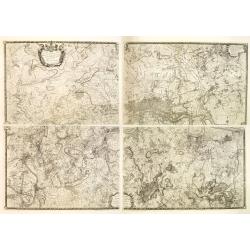
![[No tittle] Le Luxembourg Electorat de Treves. N° 175. F.le 69.](/uploads/cache/30743-250x250.jpg)
[No tittle] Le Luxembourg Electorat de Treves. N° 175. F.le 69.
Map of Luxembourg. Detailed map with Sierck, Tholey. . . Prepared under the direction of César-François Cassini de Thury and engraved by Foin.Map 141 bis. [Luxembourg],...
Date: Paris, 1763
Selling price: ????
Please login to see price!
Sold in 2018
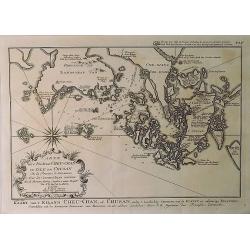
Kaart van't Eiland Cheu-chan of Chusan. . .
A detailed map of Zhoushan Island & Zhajiang China (The coastal area east of Ningbo in the Chinese province of Chekiang, located across the bay from Shanghai). The or...
Date: Paris, 1763
Selling price: ????
Please login to see price!
Sold in 2021
Nieuwe Kaart van de KAAP DER GOEDE HOOPE en der na by gelegen Landen.
An old colored map of the Cape of Good Hope in South Africa showing mountains and naming towns, rivers and shore locations. With large margins.
Date: Amsterdam, 1763
Selling price: ????
Please login to see price!
Sold in 2019
Neue und vollstandige Postkarte durch ganz Deutschland : Mit Kayserl. allergnad. Privilegio / verfertigt von Iohann Iacob von Bors zu Overen . und nach seinem Ableben ubersehen von Franz Ioseph Heger. . .
A uncommon post road mapspost route map of Germany, Poland, Austria, Switzerland and the Low countries. Highly detailed map, showing post offices with the intermediate di...
Date: Nuremberg, 1764
Selling price: ????
Please login to see price!
Sold in 2012
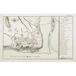
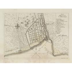
Plan de la Ville de Québec.
A detailed plan the territories of city of Québec. With a lettered key, indicating the principal places in town.The only issue of this version of Bellin's map, slightly ...
Date: Paris, 1764
Selling price: ????
Please login to see price!
Sold in 2021
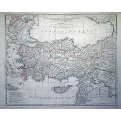
Asiae, quae vulgo Minor Dicitur, et Syriae...
Fantastic large copper engraved map, shows (parts of): Turkey, Black Sea, Mediterranean Sea, Aegean Sea and Greek islands, Crete, Cyprus, part of Armenia, Lebanon, and Sy...
Date: Paris, 1764
Selling price: ????
Please login to see price!
Sold in 2012
La Nouvelle France où Canada.
This chart shows the territories of New-France and Canada the day before the signature of the treaty of Paris.The only issue of this version of Bellin's map, slightly lar...
Date: Paris, 1764
Selling price: ????
Please login to see price!
Sold in 2013