Browse Listings
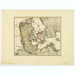
Nieuwe kaart van het Koninkryk van Deenemarken
A detailed and well engraved map of the kingdom of Denmark by one of the most important publishers in 18th century Amsterdam. With a box title and mileage scales below. I...
Date: Amsterdam, 1760
Selling price: ????
Please login to see price!
Sold in 2021
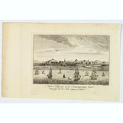
Fort St. George on the Coromandel Coast, Belonging to the East India Company of England.
A fine copperplate engraving of Fort St. George, Madras (Chennai )on the south east coast of India. The fort flies the Union Jack flag, and many sailing vessels are seen ...
Date: London, ca 1760
Selling price: ????
Please login to see price!
Sold in 2019
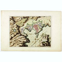
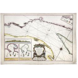
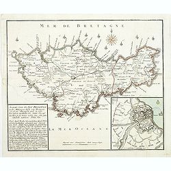
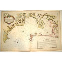
Plan of the town and harbour of Collioure.
Plan of the town and harbour of Collioure, a commune in the southern French department of Pyrénées-Orientales. In upper right Plate LXIX. Thomas Jefferys (c. 1719 – 1...
Date: London, ca. 1760
Selling price: ????
Please login to see price!
Sold in 2023
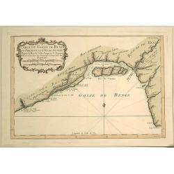
Carte du Golfe de Benin et Parte de la Cote de Guinee.
Attractive map of the infamous Slave Coast and the mouth of the Congo River showing soundings, anchorages and good coastal detail. The map features many place names, inc...
Date: Paris, 1760
Selling price: ????
Please login to see price!
Sold in 2019
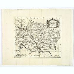
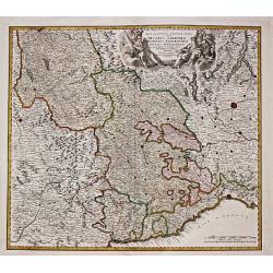
Hungary.
A map of mid eighteenth century copperplate map of Hungary, with a decorative title cartouche. Bordered by Poland, Slavonia, Turkey, Moldova and Romania. Map is split int...
Date: London, ca 1760
Selling price: ????
Please login to see price!
Sold in 2020
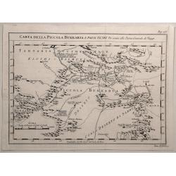
Carta Della Piccola Bukkaria e Paesi Vicini per Servire alla Storia Generale de Viaggi.
Interesting map of the Russian / Chinese border including Mongolia and the Gobi Desert. Jacques Nicolas Bellin (1703-1772) was one of the most important and proficient...
Date: Paris, 1760
Selling price: ????
Please login to see price!
Sold in 2020
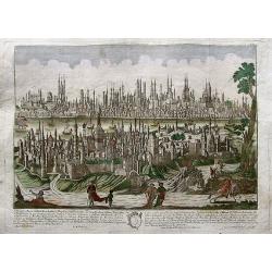
Constantinopolis.
Beautiful optical print (vues d'optique) of Constantinople, in the forefront with Galata and Pera. A very detailed image of the city, filled with buildings, towers, ships...
Date: Augsburg, ca. 1760
Selling price: ????
Please login to see price!
Sold in 2019
Carte particuliere de la Cote Occidnetale de L'Afrique.
Very large two-piece map of the West African coast from Cap de Verga to Cap Blanc. High detail along coast and main rivers. (Gambia & Senegal)Jean Baptiste d'Anville ...
Date: Paris, 1761
Selling price: ????
Please login to see price!
Sold in 2016
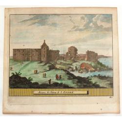
Mazures du Chateau de S. Andre.
Hand-colored copper engraved view of the ruins of the Castle of Saint Andrew, a former royal burgh on the east coast of Fife in Scotland, named after St. Andrew, the Apos...
Date: Amsterdam, 1761
Selling price: ????
Please login to see price!
Sold in 2014
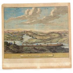
Vue de la Ville de Newaberdene du cote de Blockhause.
Striking hand colored, copper engraved view of Aberdene, Scotland. Pieter van der Aa (1659 - 1733) was a Dutch publisher, best known for preparing maps and atlases. He ...
Date: Amsterdam, 1761
Selling price: ????
Please login to see price!
Sold in 2014
An Accurate Map of Great Britain from the latest & best Observations.
Striking and highly detailed s copper engraved map of the United Kingdom. The map shows cities, towns, rivers, roads, lakes, islands and regional divisions. A large deco...
Date: London, 1761
Selling price: ????
Please login to see price!
Sold in 2018

Vue de la superbe Entrée de l'Embassadeur de Siam a la Cour de Pekin.
So-called optical print illustrating a pompous parade to celebrate the arrival of the ambassador of Siam in Beijing.Mondhare was a well-known publisher of optical prints,...
Date: Paris, 1761
Selling price: ????
Please login to see price!
Sold
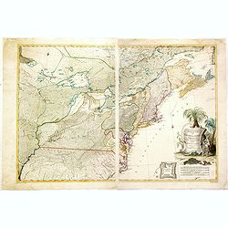
Theatrum belli in America Septentrionali. II. foliis comprehensum jussu Acad. Reg. Scient. et Eleg. Litt. exhibet I. C. Rhode Ac: Geogr.
Separately issued map of the northeastern part of the United States and Eastern Canada from the Mississippi Valley to the Atlantic Seaboard, published during the French a...
Date: Berlin, 1761
Selling price: ????
Please login to see price!
Sold in 2018
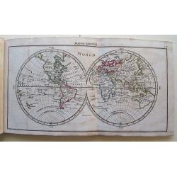
A New, General, and Universal Atlas...
Published by A. Dury, Robert Sayer & Carrington Bowles; oblong 12mo; engraved title, dedication plus 39 Copper Engraved Maps (Complete) Incl 6 folding. The folding ma...
Date: London, 1761
Selling price: ????
Please login to see price!
Sold in 2016
![[Four butterflies on one sheet]](/uploads/cache/37433-250x250.jpg)
[Four butterflies on one sheet]
Beautifully hand-colored copper engraving of 4 butterflies on one sheet, from "Beyträge zur Natur- oder Insecten-Geschichte." By the engraver and publisher Chr...
Date: Nuremberg, 1761
Selling price: ????
Please login to see price!
Sold in 2019
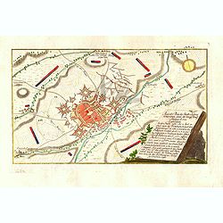
Accurater Plan der Stadt u: Vestung Schweidnitz. samt der Köngl. Preusse Attaque A: 1758. . .
Detailed colored map shows the Battle of Swidnica in Poland - during the Seven Years' Warm in 1758. The key on the right-hand side explains the events and the position of...
Date: Nuremberg: Raspische Handlung, 1761
Selling price: ????
Please login to see price!
Sold in 2016
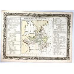
Description des Gaules Celtique et Belgique
A fine map of Gallic France and Belgium by Claude Buy de Mornas. It is from “Atlas Méthodique et Elémentaire de Géographie et l’ Histoire”, published in 1761.The...
Date: Paris, 1761
Selling price: ????
Please login to see price!
Sold in 2017
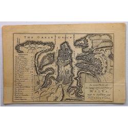
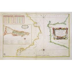
An Exact Plan of the Capital City and Port of Malta, with its Suburbs and Dependencies .
A detailed plan of Valletta, dedicated to the 'Grand Officers of the Order of St. John'.The map of Valletta is accompanied with a lettered and numbered key, identifying b...
Date: London, 1761
Selling price: ????
Please login to see price!
Sold in 2017
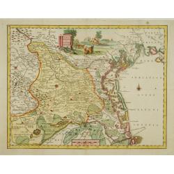
Nova Tabula Geographica exhibens Ducatum Brabantiae Cum Pertinentiis et adjacentibus Regionibus . . .
A detailed regional map of Brabant, centered on Antwerp, Brusells, Mechlen and Louvain in Belgium, and extending north to Breda and east to Maastricht. Map is by Conrad L...
Date: Augsburg, 1761
Selling price: ????
Please login to see price!
Sold in 2019
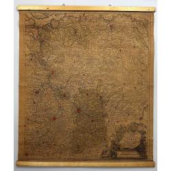
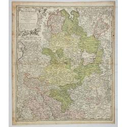
Ducatus Iuliacensis, Cliviensis et Montensis, ut et Principatus Meursiani et Comitatus Zutphaniensis Novissima et Accuratissima Delineatio.
Map of North Rhine-Westphalia (Germany) featuring the Duchies of Iuliacensis, Cliviensis and Berg. The map has a very large cartouche featuring five crests with crowns, a...
Date: Augsburg, 1761
Selling price: ????
Please login to see price!
Sold in 2019
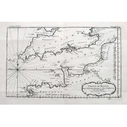
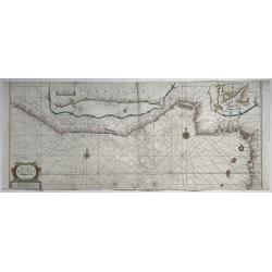
Costes de France depuis Brest jusqu'a Dunkerque...
An interesting chart of the Channel with the English and French coasts. Extends from Bristol to Cornwall, all the way to London and Kent in England; and from Brest to Par...
Date: Paris, 1761
Selling price: ????
Please login to see price!
Sold in 2017
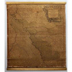
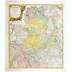
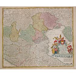
Circuli Westphaliae Quoad Partem Septentrionalem. . .
A fine detailed regional map of Westphalia in Germany, extending from Bremen and Hamburg in the north to Cologne, Bonn, Dusseldorf, Aix, Wyck and Luttich in the south. Ar...
Date: Nuremberg, 1761
Selling price: ????
Please login to see price!
Sold in 2019
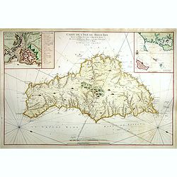
Carte De L'Isle De Belle-Isle. . .
Large-scale sea chart of Belle-Ile, in upper right corner inset of the French coast with Belle-Ile, îles de Quiberon with the bay of Morbihan. With rhumb lines.Published...
Date: Paris, 1761
Selling price: ????
Please login to see price!
Sold in 2018
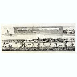
The East Prospect of the City of Philadelphia, in the Province of Pennsylvania.
This copper engraving view is based on the famous George Heap view, first published in c.1756. The print shows the city as a bustling river port of some importance and so...
Date: London, 1761
Selling price: ????
Please login to see price!
Sold in 2019
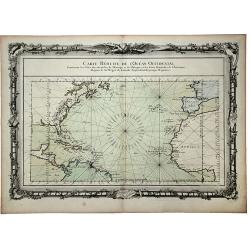
CARTE REDUITE de l' OCEAN OCCIDENTAL, Contenant les Costes Occidentales de l'Europe et de l' Afrique et les Cotes Orientales de l'Amerique . . .
This beautifully engraved chart shows the Atlantic Ocean north of the equator, delineated with rhumb lines. A good portion of each of the continents is shown with major p...
Date: Paris, 1761
Selling price: ????
Please login to see price!
Sold in 2020
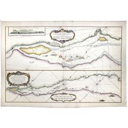
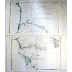
Partie du Cours du Fleuve de Saint Laurent... / Carte du Cours du Fleuve de Saint Laurent depuis Quebec jus.
A map of the banks of the St. Lawrence river from Quebec to the Atlantic in 2 sheets.[The other sheet also present in this auction !]Two charts horizontally oriented wit...
Date: Paris, 1761
Selling price: ????
Please login to see price!
Sold in 2020
Carte du Cours du Fleuve de Saint Laurent. Depuisla Mer jusqu'a Quebec en Deux feuilles . . .
A map of the banks of the St. Lawrence river from Quebec to the Atlantic in 2 sheets. [1 of 2] Two insets with maps entitled "Baye des Sept Isles" and "Les...
Date: Paris, 1761
Selling price: ????
Please login to see price!
Sold in 2020
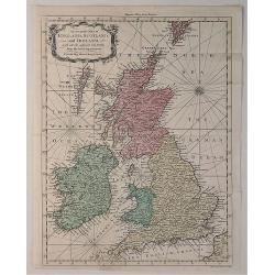
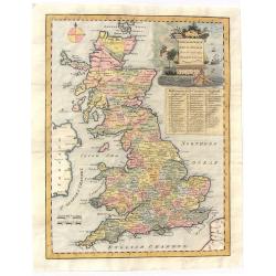
An Accurate Map of England, Scotland and Ireland. . .
A fine hand-colored map of England, Scotland & Ireland by Seale, it was published in the “UNIVERSAL MAGAZINE” BY Hinton. colored by region, it features a decorati...
Date: London, 1761
Selling price: ????
Please login to see price!
Sold in 2020
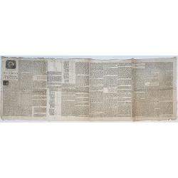
Octroy voor de Westindische Compagnie. . . 1761.
Full title: 'Nader prolongatie van het octroy voor de Westindische Compagnie voor den tyd van nog dertig jaaren'. A large broadside printed on four joined sheets publishe...
Date: 's-Gravenhage, 1761
Selling price: ????
Please login to see price!
Sold in 2021
Circuli Westphaliae. . .
A nice, detailed map of Westphalia. Larger towns and cities are highlighted in red - these include, Bremmen, Hamburg, Cologne, Aix, Bonn, Munster, Meppen, Hannover, Emden...
Date: Nuremberg, 1761
Selling price: ????
Please login to see price!
Sold in 2021
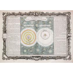
A celestial chart depicting the astronomical systems according to Ptolemy and to Tycho Brahe.
A celestial chart depicting the astronomical systems according to Ptolemy and to Tycho Brahe. Claude Buy de Mornas (dl 1783), géographe du roi (1764). Atlas 'Méthodique...
Date: Paris, 1761
Selling price: ????
Please login to see price!
Sold in 2020
![SUITE DE L'HISTOIRE DES GOMERITES [ANCIENT GREEK MYTHOLOGICAL WORLD VIEW]](/uploads/cache/84967-250x250.jpg)
SUITE DE L'HISTOIRE DES GOMERITES [ANCIENT GREEK MYTHOLOGICAL WORLD VIEW]
A scarce map of the Ancient World. It includes plenty of french text and remarkably decorative borders found only in the deluxe edition of Buy De Mornas' 'Atlas Methodiqu...
Date: Paris, 1761
Selling price: ????
Please login to see price!
Sold in 2021
![[The Americas] AMERIQUE](/uploads/cache/20599-(2)-250x250.jpg)
[The Americas] AMERIQUE
A map depicting both the Americas. With on both sides a descriptionary text. All within an elaborate and very decorative border. Claude Buy de Mornas (d. 1783), géogra...
Date: Paris, 1761
Selling price: ????
Please login to see price!
Sold in 2025
A Large Chart of the Coast of Guinea From Sherbro To Cape Lopas
A large coastal sea chart with rhumb lines of mainly the Gold Coast, by Francis Lamb, published in 'The English Pilot, part V, 6th edition', London, Mount and Page, 1761....
Date: London, 1761
Selling price: ????
Please login to see price!
Sold in 2022
![Atlas Méthodique et Elémentaire de Geographie et d'histoire Dedie a Monsieur le President Henault. [4 volumes]](/uploads/cache/49026A-250x250.jpg)
Atlas Méthodique et Elémentaire de Geographie et d'histoire Dedie a Monsieur le President Henault. [4 volumes]
This is a very fine, typical French atlas, complete in its four volumes and very nice contempt. calf binding. It is in its rare first edition. The first edition of this a...
Date: Paris, 1761
Selling price: ????
Please login to see price!
Sold in 2024

Matching set of four wallmaps of America, Asia, America, Europe.
Rare and decorative set of four wall maps published by Louis Charles DESNOS ( fl.1750-1770), including a border with vignettes describing native scenes. Each panel is acc...
Date: Paris, 1760-1761
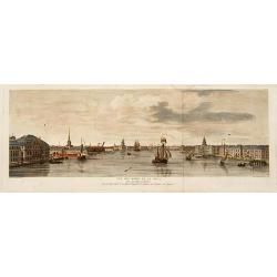
Vue des bords de la Neva..
Sight of the edges of the river Neva between the Winter palace and the imperial Academy of sciences at Saint-Petersburg.
Date: Saint-Petersbourg 1761
Selling price: ????
Please login to see price!
Sold
Mappamondo ouerbo descrizione del Globo Terrestre . . .
Attractive Italian world map in double hemisphere. With curious outlines for North Americas west coast and Australia, with "Terra di Diemen", joined to the main...
Date: Venice, 1761
Selling price: ????
Please login to see price!
Sold in 2011
Carte generale du globe terrestre construite & publiee par le S.r Isaac Brouckner geographe de S.M.I.C. exaninee & approuvee par M.r Daniel Bernoulli . . .
Attractive Italian world map presented in Mercator's projection and centered on Australia. Included in "Dizionario geografico portatile".Featuring the voyage of...
Date: Venice, 1761
Selling price: ????
Please login to see price!
Sold in 2011
De la Longitude et de la Latitude. / Suite de la Longitude.
Claude Buy de Mornas (d. 1783), géographe du roi (1764). Atlas Méthodique et Elémentaire de Géographie et d' Histoire, 1761, Atlas Historique et Géographique, 1762. ...
Date: Paris, L.C. Desnos, 1761
Selling price: ????
Please login to see price!
Sold in 2018
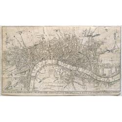
A correct plan of the cities of London & Westminster & Borough of Southwark including the bills o mortality with the additional buildings
This map of London was published as supplement to Volume 30 of the 'London Magazine' in 1761. Attributed to John Rocque, the map's title features in a panel below the pla...
Date: London, 1761
Selling price: ????
Please login to see price!
Sold in 2013
Carte De L'Isle De Belle-Isle..
Large-scale sea of Belle-Ile, in upper right corner inset of the French coast with Belle-Ile, îles de Quiberon with the bay of Morbihan. With rhumb lines.Published by t...
Date: Paris, 1761
Selling price: ????
Please login to see price!
Sold
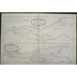
Carte du Detroit de Gibraltar Dressée au Depost des Cartes et Plans de la Marine pour le service des Vaisseaux du Roy par Ordre de M. le Duc de Choiseul Ministre de la Guerre et de la Marine. . . N° 35
A very detailed chart prepared by J.N. Bellin of the Straits of Gibraltar locating harbors and bays and coastal soundings. Decorative title cartouche. Depicts Cape Trafal...
Date: Paris, 1761
Selling price: ????
Please login to see price!
Sold in 2009

Vue de la superbe Entrée de l'Embassadeur de Siam a la Cour de Pekin.
So-called optical print illustrating a pompous parade to celebrate the arrival of the ambassador of Siam in Beijing.Mondhare was a well-known publisher of optical prints,...
Date: Paris, 1761
Selling price: ????
Please login to see price!
Sold in 2010

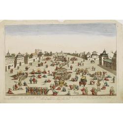
Vue perspective de la grande Ceremonie du Couronnement de l'Empereur de la Chine.
So-called optical print illustrating the crowning of the Chinese emperor. It shows the throne at the center.Mondhare was a well-known publisher of optical prints, establi...
Date: Paris, 1761
Selling price: ????
Please login to see price!
Sold
Ceremonie de la grande Feste que les Chinois celebre le 24 de la Lune d'Aoust..
So-called optical print illustrating great festivities on the 24th of August in Beijing.Mondhare was a well-known publisher of optical prints, established in Paris, at ru...
Date: Paris, 1761
Selling price: ????
Please login to see price!
Sold

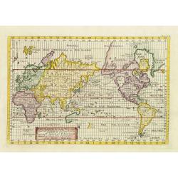
Climats d'Heures et de Mois.
Decorative map of the world showing one hemisphere divided into climates according to the length of the day.Left and right a box with information about these climates.Pre...
Date: Paris, 1761
Selling price: ????
Please login to see price!
Sold in 2009
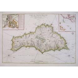
Accurate Carte des insul BelleIsle an der Mittägien Küste von Bretagne. . .
Map of Belle Isle. In the lower left corner a descriptive text with a chronology of the siege and occupation of the island "Accurate Carte der INSUL BELLE ISLE [Bell...
Date: Nurnberg, 1761
Selling price: ????
Please login to see price!
Sold
Partie du Cours du Fleuve de Saint Laurent... Carte du Cours du Fleuve de Saint Laurent depuis Quebec jus
Two charts horizontally oriented with tremendous detail of the rivers and shoreline. Decorated with three rococo-style cartouches and rhumb lines.Good margins sheet size ...
Date: Paris, 1761
Selling price: ????
Please login to see price!
Sold in 2014
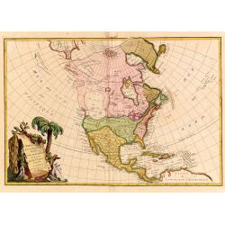
L'Amerique Septentrionale divisé en fes principaux.
A finely engraved map of North America, prepared by Janvier. The map is most notable for it's depiction of Mer de L'Quest or Sea of the West, a great sea, easily the size...
Date: Paris 1762
Selling price: ????
Please login to see price!
Sold
Carte Hydrographique de la Baye de Cadix..
A large and very handsome chart of the Bay of Cadiz, from the town of Rota to Cadiz. The piece contains dramatic coastal topography, forts, anchorages and soundings. Beau...
Date: Paris, 1762
Selling price: ????
Please login to see price!
Sold
Ducatus Sabaudiae, Principatus Pedemontium et ducatis Montisferrati.
Johan Baptist Homann (1663-1724). Outstanding German cartographer. Founder of the Homann publishing house. After the death of the son Johann Christoph, the firm continued...
Date: Nurnberg, 1762
Selling price: ????
Please login to see price!
Sold
Dominii Veneti.
Johan Baptist Homann (1663-1724). Outstanding German cartographer. Founder of the Homann publishing house. After the death of the son Johann Christoph, the firm continued...
Date: Nürnberg, 1762
Selling price: ????
Please login to see price!
Sold
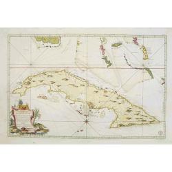
Carte Réduite De L'Isle De Cube..
A well engraved and highly detailed chart that was issued in Neptune americo-septentrionale. This chart is based on Sayer & Bennett's chart that was issued in 1776 an...
Date: Paris, 1762
Selling price: ????
Please login to see price!
Sold
![[Title page] Nouvel Atlas de la Généralité de Paris Divisé En ses 22 Elections ..](/uploads/cache/17245-250x250.jpg)
[Title page] Nouvel Atlas de la Généralité de Paris Divisé En ses 22 Elections ..
Decorative title page with Mercury, Neptune, ships merchants, etc.
Date: Paris, 1762
Selling price: ????
Please login to see price!
Sold
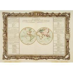
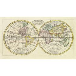
Hémisphére Occidental.
Double hemisphere world map.Left and right a box with geographical information for spheres of different types.Prepared by Buy de Mornas, who was a professor of geography ...
Date: Paris 1762
Selling price: ????
Please login to see price!
Sold
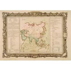
Asie.
Map of Asia. With a curiously shaped Australia, and marked Partie du Continent inconnu.Left and right a box with geographical information for Asia.Prepared by Buy de Morn...
Date: Paris 1762
Selling price: ????
Please login to see price!
Sold
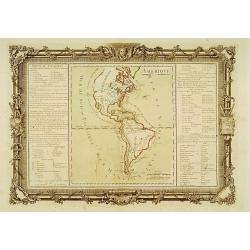
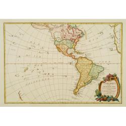
Amérique.
Map of north and south America.Left and right a box with geographical information for America.Prepared by Buy de Mornas, who was a professor of geography and history and ...
Date: Paris 1762
Selling price: ????
Please login to see price!
Sold
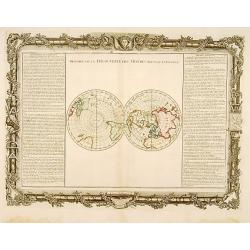
Histoire de la Découverte des Mondes Nouveau et Inconnu.
Double hemisphere map of the Arctic and Antarctic poles.Left and right a box with geographical information about the discovery of America and the arctic and Antarctic ear...
Date: Paris 1762
Selling price: ????
Please login to see price!
Sold
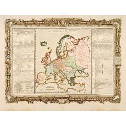
Souverainetés de l'Europe.
Map of the various sovereignty of Europe.Left and right a box with geographical information about the various Empires of Europe .Prepared by Buy de Mornas, who was a prof...
Date: Paris 1762
Selling price: ????
Please login to see price!
Sold
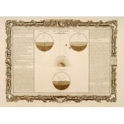
De l'Aërologie.
Decorative chart showing various celestial models.Left and right a box with geographical information about the Aero logy, Refraction, and Twilight.Prepared by Buy de Morn...
Date: Paris 1762
Selling price: ????
Please login to see price!
Sold
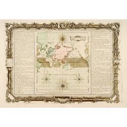
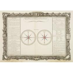
Pour les Vents.
Finely engraved chart shows the wind currents in the Atlantic, Indian and Pacific Oceans, and the Arctic and Antarctic regions. Depicts 4 compass roses with wind directio...
Date: Paris 1762
Selling price: ????
Please login to see price!
Sold
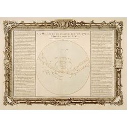
La Manière de reconnoitre kes Principales Etoiles dans le Ciel.
Decorative chart of the Milky Way and positions of the stars in the Sky. Left and right a box with geographical information about the welkin .Prepared by Buy de Mornas, w...
Date: Paris 1762
Selling price: ????
Please login to see price!
Sold
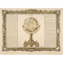
Globe Céleste.
Attractive engraved celestial globe, oriented to show Leo, Taurus, Virgo, Ursa Major and Minor, Cancer and a handful of other constellations.Left and right a box with geo...
Date: Paris 1762
Selling price: ????
Please login to see price!
Sold
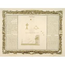
Des Planètes.
Interesting engraving showing contemporary instruments for charting the heavens and implementation of the instruments to observe the stars.Left and right a box with infor...
Date: Paris 1762
Selling price: ????
Please login to see price!
Sold
Des Planètes subalternes et de la Paralaxe.
Decorative engraving showing the phases of the moon.Left and right a box with geographical information about various planets .Prepared by Buy de Mornas, who was a profess...
Date: Paris 1762
Selling price: ????
Please login to see price!
Sold
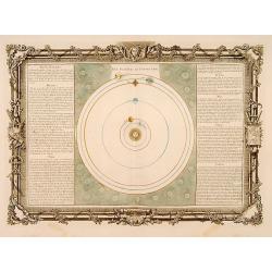
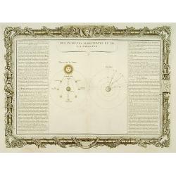
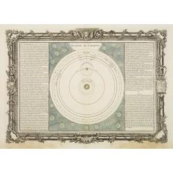
Des Planètes en Particulier.
Chart of the solar system.Left and right a box with geographical information about various planets: "Mercury, Venus, La Terre, Mars, Jupiter, Saturn.Prepared by Buy ...
Date: Paris 1762
Selling price: ????
Please login to see price!
Sold
L'Amerique divisée Pars Grands Etats. . .
Engraved by Lattré. This map is most notable for its depiction of "Mer de L'Ouest" or "Sea of the West". A great sea, easily the size of the Mediterr...
Date: Paris, 1762
Selling price: ????
Please login to see price!
Sold in 2020
Carta Geografica del Territorio Padovano.
Very fine decorative map of Venice and its immediate environs, the surrounding rice fields intersected by a network of waterways and canals.
Date: Venice, 1740-1762
Selling price: ????
Please login to see price!
Sold in 2015
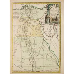
Carte de l'Egypte Ancienne et Moderne.
Jean Lattré, Paris-based engraver and publisher. Worked with Robert de Vaugondy, J. Janvier and R. Bonne. " Atlas Monderne', 1771, 1783 , 1793. Rigobert Bonne, Fren...
Date: Paris, 1762
Selling price: ????
Please login to see price!
Sold in 2019
Différentes Projections Des Cartes.
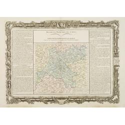
Decorative map of the region "Île de France".Left and right a box with technical information concerning the different types of maps and the methods used to con...
Date: Paris 1762
Selling price: ????
Please login to see price!
Sold
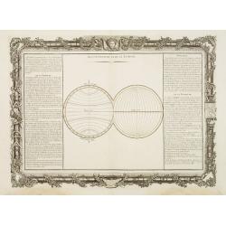
De la Longitude et de la Latitude.
Decorative map showing the division of the two hemispheres respectively into parallels and meridians.Left and right a box with information's about latitude and longitude....
Date: Paris 1762
Selling price: ????
Please login to see price!
Sold
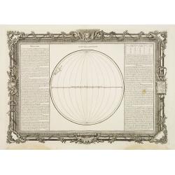
Suite de la Longitude.
Decorative map showing one hemisphere divided into meridians.Left and right a box with further information's about longitude.Prepared by Buy de Mornas, who was a professo...
Date: Paris, 1762
Selling price: ????
Please login to see price!
Sold in 2013
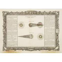
Du Zodiaque et de l'Eclyptique.
Decorative celestial chart showing the solar and lunar eclipses.Left and right a box with information about the zodiac and the ecliptic.Prepared by Buy de Mornas, who was...
Date: Paris 1762
Selling price: ????
Please login to see price!
Sold
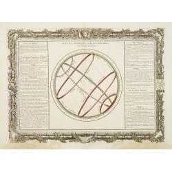
Colures, Tropiques, Cercles Polaires, et leurs Usages.
Decorative chart showing the main celestial circles.Left and right a box with information about colures as well as tropical and polar circles.Prepared by Buy de Mornas, w...
Date: Paris 1762
Selling price: ????
Please login to see price!
Sold
De l'Horison.
Decorative chart representing the right, oblique and parallel sphere.Left and right a box with information about the horizon.Prepared by Buy de Mornas, who was a professo...
Date: Paris 1762
Selling price: ????
Please login to see price!
Sold
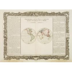
Observations sur les Points Cardinaux. Lignes et Cercles de..
Decorative world map presenting the four cardinal points on two hemispheres.Left and right a box with information about the cardinal points as well as the lines and the c...
Date: Paris, 1762
Selling price: ????
Please login to see price!
Sold in 2008
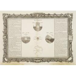
Pôles du Monde, de l'Eclyptique, et de l'Horison. Points des..
Decorative map presenting a compass rose and a wind rose.Left and right a box with information about the cardinal points, the poles as well as the equinoctial and the sol...
Date: Paris 1762
Selling price: ????
Please login to see price!
Sold
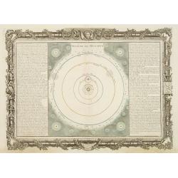
Sistême de Descartes.
Decorative celestial map representing the solar system as conceived by Descartes.Left and right a box with information about the philosopher's ideas about the outer space...
Date: Paris 1762
Selling price: ????
Please login to see price!
Sold
Sistême de Copernic.
Decorative celestial map representing the solar system as conceived by Copernicus.Left and right a box with information about the philosopher's ideas about the outer spac...
Date: Paris 1762
Selling price: ????
Please login to see price!
Sold
