Browse Listings
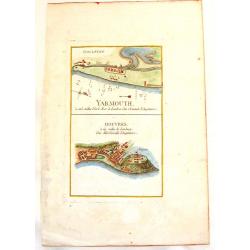
Yarmouth & Douvres.
An interesting copper engraved map showing the ports of Yarmouth and Dover in England. Louis Charles Desnos (1725-1805) was a geographer, bookseller and engineer, and ma...
Date: Paris, 1760
Selling price: ????
Please login to see price!
Sold in 2013
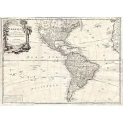
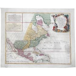
L'Amerique divisée en ses principaux Etats.
A large uncommon map published by Lattré. This map is most notable for it's depiction of Mer ou Baye de L'Quest or Sea of the West. A great sea, easily the size of the M...
Date: Paris, c 1760
Selling price: ????
Please login to see price!
Sold in 2014
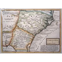
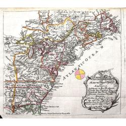
Carolina By H. Moll, Geographer.
A detailed map that includes the Limit of King Charles ye II Granted to ye Present Proprietors of Carolina in 1663, the south bounds of Carolina (well into Florida), note...
Date: London, c 1760
Selling price: ????
Please login to see price!
Sold in 2013
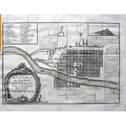
Plan de la ville de Santiago. . .
Early plan of Santiago de Chile, showing the squarish arranged streets, the Río Mapocho and its canals. A key identifies 23 churches and 5 important places on the map.
Date: Paris, c1760
Selling price: ????
Please login to see price!
Sold in 2013
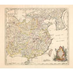
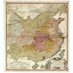
China as surveyed by the Jesuit Misionaries between the years 1708 & 1717 with Korea & the adjoining parts of Tartary.
The map is of interest for the use of Eastern Sea or Sea of China, the sea south of Korea. In the sea along the coast line of Korea : "Kau-Li-Qua or King:m of Korea&...
Date: London, c. 1760
Selling price: ????
Please login to see price!
Sold in 2014
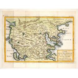
Carte de la Macedoine, de la Thessalie et de L'Epire.
Interesting copper engraved map of the Balkan region including what is currently Macedonia, Albania and northern Greece. Block style title cartouche. Jacques Nicolas Bel...
Date: Paris, 1760
Selling price: ????
Please login to see price!
Sold in 2013
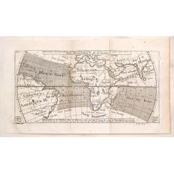
Representation du Cours Ordinaire des Vents de Traverse Qui Regnent le Long des Cotes dans la Mer Atlantique & celle des Indes.
This map shows the prevailing winds in the North Atlantic and Indian Oceans. Published in "Histoire Generale des Voyages". The engraver was Cosmant. Jacques N...
Date: Paris, 1760
Selling price: ????
Please login to see price!
Sold in 2019
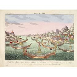
Vue de Siam avec diverses Sortes des Ballons, ou Vaisseaux Chinoise a rame.
So-called optical print illustrating a parade of vessels. Engraved by F.X. Habermann (1721-1796). The Academie Imperiale was a well-known publisher of optical prints, est...
Date: Augsburg, 1760
Selling price: ????
Please login to see price!
Sold in 2014
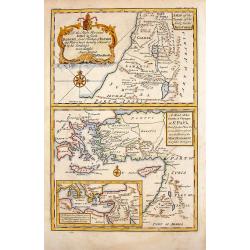
A Map of the Travels of Our Lord & Saviour, Jesus Christ.
This lovely, 3 part, religious map includes the Travels of Jesus, St. Paul and Holy Land places referred to in the New Testament. It is by Stackhouse and comes from his B...
Date: London, 1760
Selling price: ????
Please login to see price!
Sold in 2015
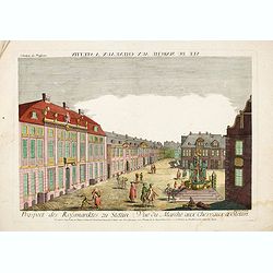
Vue du Marché aux Cheveaux a Stettin.
Rare so-called optical print illustrating the Horse market of Stettin in Poland.
Date: Augsburg, 1760
Selling price: ????
Please login to see price!
Sold in 2016
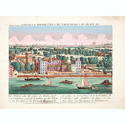
Der Pallast oder Residenz des Erzbischoffs von Canterbury ganandt Lambeth, an der Themse zu London. . .
Rare so-called optical print illustrating Lambeth Palace, the official London residence of the Archbishop of Canterbury, with a detailed view of London in the Background ...
Date: Augsburg, 1760
Selling price: ????
Please login to see price!
Sold in 2017

Der innere Prospect in der St. Peters Kirche in Rome. . .
Rare so-called optical print illustrating the interior of St. Paul in the Vatican. Engraved by Jean Benoit Winckler.The Academie Imperiale was a well-known publisher of o...
Date: Augsburg, 1760
Selling price: ????
Please login to see price!
Sold in 2014
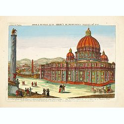
Die prachtige Sr. Peters Kirche im Vatican zu Rom. . . - Vuë de l'Eglise Cathetrade de St. Pierre au le Vatican a Rome.
Rare so-called optical print illustrating the St. Peter's Basilica in the Vatican. Engraved by Jean Benoit Winckler after Joseph Vasi.The Academie Imperiale was a well-kn...
Date: Augsburg, 1760
Selling price: ????
Please login to see price!
Sold in 2017
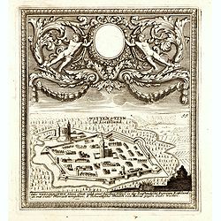
(Paide) Wittenstein in Lieffland / Wittenstein in Lieffland Oder Weissenstein kleine Stadt nebst eine Starken Schloss in der Lieflandische Provinz Estland. . .
Rare bird's eye view of Paide in Estonia by George Christian Kilian. The upper part of the engraving has very nice baroque decoration with an empty shield.Georg Christian...
Date: Augsburg, 1760
Selling price: ????
Please login to see price!
Sold in 2014
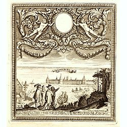
Noteburg. (Schüsselburg) / Ist eine hauptsächliche Festung an dem See Ladoga, wo der Fluss Nieva hinein fallt. . .
Rare bird's eye view of Schlüsselburg, east of St. Petersburg by George Christian Kilian. The upper part of the engraving has very nice baroque decoration with an empty ...
Date: Augsburg, 1760
Selling price: ????
Please login to see price!
Sold in 2014
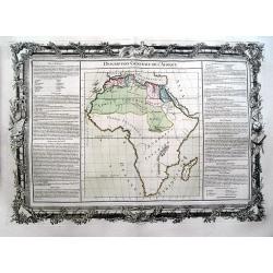
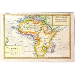
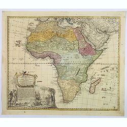
Description Générale De L'Afrique.
Decorative map of Africa. Only limited interior detail. Side panels of text with lengthy information on the various regions.
Date: Paris, ca. 1760
Selling price: ????
Please login to see price!
Sold in 2014
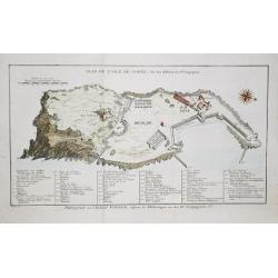
Plan de l' Isle de Gorée, sur les desseins du Sr. Compagnon.
Jan van Schley is the engraver of the maps (by J.N. Bellin) and views in the Dutch edition of A.F. Prévost d' Exile's 'Histoire Géneral des Voyages'.A plan of the islan...
Date: Amsterdam, c. 1760
Selling price: ????
Please login to see price!
Sold in 2018
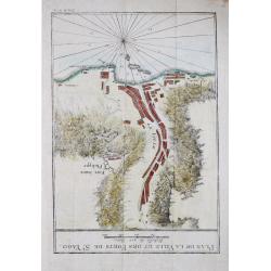
Plan de la Ville et des Forts de St. Jago
Jan van Schley is the engraver of the maps (by J.N. Bellin) and views in the Dutch edition of A.F. Prévost d' Exile's 'Histoire Géneral des Voyages'.Plan of the town an...
Date: Amsterdam, c. 1760
Selling price: ????
Please login to see price!
Sold in 2018
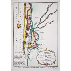
Carte de l' Entree de la Riviere de Sanaga ou Senegal.
Jaques Nicolas Bellin (1702-720) was the most important French hydrographer of the 18th century. Sea-atlas 'Hydrographique Français' , 1756-65, atlas to accompany Prévo...
Date: Amsterdam, c. 1760
Selling price: ????
Please login to see price!
Sold in 2018
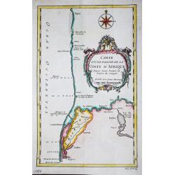
Carte d' une partie de la Coste d' Afrique Depuis Tanit jusq'a la Riviere de Senegal.
Jaques Nicolas Bellin (1702-720) was the most important French hydrographer of the 18th century. Sea-atlas 'Hydrographique Français' , 1756-65, atlas to accompany Prévo...
Date: Paris, c. 1760
Selling price: ????
Please login to see price!
Sold in 2018
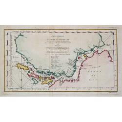
Carte réduite du Détroit de Magellan
Jaques Nicolas Bellin (1702-720) was the most important French hydrographer of the 18th century. Sea-atlas 'Hydrographique Français' , 1756-65, atlas to accompany Prévo...
Date: Amsterdam, c. 1760
Selling price: ????
Please login to see price!
Sold in 2020
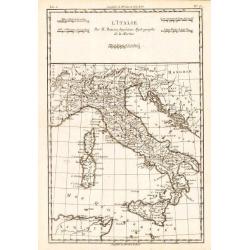
L'Italie.
Rigobert Bonne (1727-1795), French cartographer. His maps are found in a.o. Atlas Moderne (1762), Raynal's Histoire Philos. du Commerce des Indes (1774) and Atlas Encyclo...
Date: Amsterdam, c. 1760
Selling price: ????
Please login to see price!
Sold in 2018
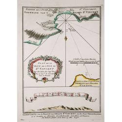
Plan de la Baye de l' Isles de St. Vincent / Vue de l' Isles de St. Vincent.
Jaques Nicolas Bellin (1702-720) was the most important French hydrographer of the 18th century. Sea-atlas 'Hydrographique Français' , 1756-65, atlas to accompany Prévo...
Date: Amsterdam, c. 1760
Selling price: ????
Please login to see price!
Sold in 2018
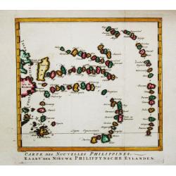
Carte des Nouvelles Philipines.
Jaques Nicolas Bellin (1702-720) was the most important French hydrographer of the 18th century. Sea-atlas 'Hydrographique Français' , 1756-65, atlas to accompany Prévo...
Date: Amsterdam, c. 1760
Selling price: ????
Please login to see price!
Sold in 2014
A New & Correct Map of Negroland and Guinea, by G.Rollos Geogr.
A detailed copper engraved map of West Africa published in Fenning's ‘A New System of Geography’.
Date: London, 1760
Selling price: ????
Please login to see price!
Sold in 2018
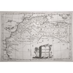
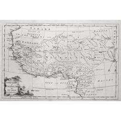
An Accurate Map of Barbary, by G.Rollos Geogr.
A detailed copper engraved map of North Eest Africa published in Fenning's ‘A New System of Geography’.
Date: London, 1760
Selling price: ????
Please login to see price!
Sold in 2014
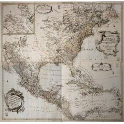
Mappa Geographica Americae Septentrionalis ad Emendatiora Exemplaria adhuc Edita . . .
Printed from 4 plates and showing the northern half continent with the Caribbean. Copper engraved map with original outline color, printed from 4 plates, after Leonhard E...
Date: Berlin c. 1760
Selling price: ????
Please login to see price!
Sold in 2014
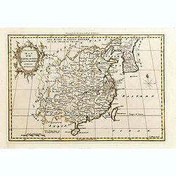
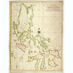
A New & Accurate Map of the Empire of China, from the Sieur Robert's Atlas, with Improvements.
Nice example of Bowen's map of China with neighboring Korea and Formosa published for the 'Geographical Dictionary' in London around 1760. Excellent detail, decorative ca...
Date: London, 1760
Selling price: ????
Please login to see price!
Sold in 2015
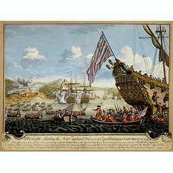
A View of the Landing the New England Forces in ye Expedition against Cape Breton, 1745.
Depicting a view of the fortress siege at Louisbourg in New France in 1745, done by J. Steven and "Printed for John Bowles at the Black Horse in Cornhill & Carri...
Date: London, ca. 1760
Selling price: ????
Please login to see price!
Sold in 2017
Regni Sinae vel Sinae propriae..
General map of China, including the islands of Taiwan and Hainan. The map is based on the work of du Halde. An appealing title cartouche bottom right with allegorical ima...
Date: Nuremberg, 1760
Selling price: ????
Please login to see price!
Sold in 2015
Carte de l'Isle de la Grenade Dressee au Depost des Cartes et Plans de la Marine...
Large-scale sea chart of this mountainous island in the Windward Islands with great detail of the roads, villages, and ports. Above the decorative title cartouche is a pr...
Date: Amsterdam, 1760
Selling price: ????
Please login to see price!
Sold in 2015
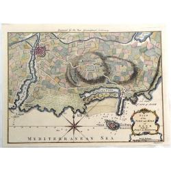
Plan of the Town and Mole of Agde with the Fort de Brescou.
Fine copper engraved map of Agde near the towns of Marseillan and Bessan, on the coastline of southern France in the Gulf of Lion. By John Hinton engraved for the "N...
Date: London, 1760
Selling price: ????
Please login to see price!
Sold in 2019
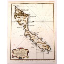
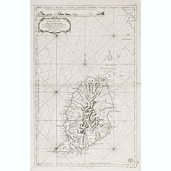
Carte de L'Isle de Jean Mayen.
Fine little copper engraved, hand colored map of the Island of Jean Mayen, off the coast of Norway. It was by Bellin. Features a decorative title cartouche.
Date: Paris, 1760
Selling price: ????
Please login to see price!
Sold in 2016
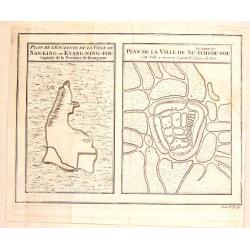
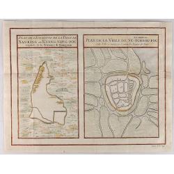
Plan de la Ville de Su-Tcheou-Fou / Plan de L'Enceinte de la Ville de Nan-King.
Two plans on one page. One is a plan of Nanking while the other is of the town of Su-Chew-Fu. Published in Paris by Jacques Nicolas Bellin in 1760.
Date: Paris, 1760
Selling price: ????
Please login to see price!
Sold in 2016
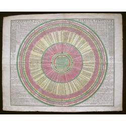
Kalendrium Juliano Romanum Perpetuum.
Perpetual calendar, based on the circulation of the planets. Such calendars were pricked on the wall and thus were destroyed easily. An example can be found on Vermeer’...
Date: Augsburg, 1760
Selling price: ????
Please login to see price!
Sold in 2015
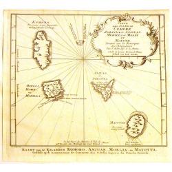
Carte des Isles de Comore Johanna.
Decorative map of the Comoros Islands, to the north of Madagascar.Includes the islands of Komoro, Mohilla, Anjuan and Mayotta. Adorned with a large fancy title cartouche....
Date: Paris, 1760
Selling price: ????
Please login to see price!
Sold in 2017
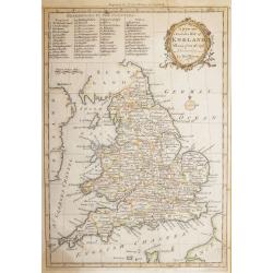
A new and Accurate Map of ENGLAND Drawn from the best Authorities by Thomas Bowen.
A detailed map of England and Wales engraved for Cowley’s History of England 1760 edition. The title is in a very ornate cartouche a list of references to the Counties ...
Date: London 1760
Selling price: ????
Please login to see price!
Sold in 2016
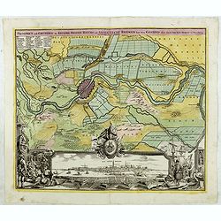
Prospect und Grundris der Keiserl. Freyen Reichs und Anse Stadt Bremen . . .
Decorative town plan of Bremen with surrounding area. In lower part a fine panoramic view.
Date: Nuremberg , ca. 1760
Selling price: ????
Please login to see price!
Sold in 2016

Vue d'Optique Representant: La Vue de la Grande Allee du Jardin de Vauxhall Prise de l'entrée
Optical print illustrating a perspective view of Vauxhall Garden in London. (No. 24e) It was produced at Chez Daumont in Paris in 1760.Vue d'Optique, is a special type of...
Date: Paris, 1760
Selling price: ????
Please login to see price!
Sold in 2015
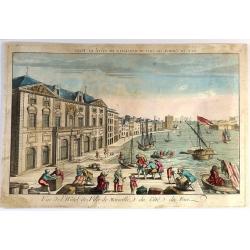
Vue de l'Hôtel de Ville de Marseille du Côté du Port.
Striking copper engraved optical print illustrating a perspective view of the City Hall of Marseille, France, taken from the harbour.In the eighteenth and nineteenth cent...
Date: Paris, 1760
Selling price: ????
Please login to see price!
Sold in 2018
Circuli Super. Saxoniae Pars Meridionalis . . .
Map of a large part of Germany and a part of the Czech Republic. The map includes the cities: Prague, Berlin, Frankfurt, Magdeburg, Brandenburg, Halle, Leipzig and Dresde...
Date: Augsburg, 1760
Selling price: ????
Please login to see price!
Sold in 2016

Dvcatvvm Livoniae et Cvrlandiae cum vicinis. . .
A very attractive of Livonia, Estonia, Curlandia and the Baltic coast.
Date: Nuremberg, 1760
Selling price: ????
Please login to see price!
Sold in 2016
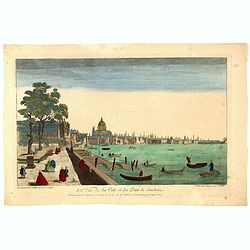
83e Vue de la Ville et du Pont de Londres.
So-called optical print of London with River Theems. Basset was a well-known publisher of optical prints, established in rue S.Jacques in Paris. In the eighteenth and nin...
Date: Paris, 1760
Selling price: ????
Please login to see price!
Sold in 2016

Het Admiraliteits of Prinsen - Hof
The Admiralty or courtyard of the Princes, the former Town Hall, seen at right with the main entrance from the side against the Princes Lane. Original copper engraving fr...
Date: Amsterdam, 1760
Selling price: ????
Please login to see price!
Sold in 2018
Afrique
A copper engraved map of the African continent. There is little detail to the coastal and northern regions, with a mostly blank interior. The majority of Africa is simply...
Date: Paris, 1760
Selling price: ????
Please login to see price!
Sold in 2016
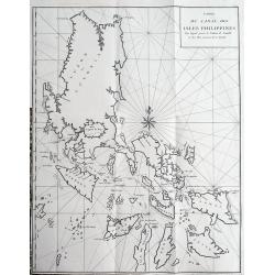
Carte du Canal des Isles Philippines Par lequel passe le Galion de Manille...
This large and detailed copper-engraved sea-chart, is one of the best obtainable maps of the Islands of the Philippines from the 18th century. It shows Islands, bays, ree...
Date: Paris, ca. 1760
Selling price: ????
Please login to see price!
Sold in 2016

Elisabeth I. Russorum Imperatrixnata 1709 d. 20 Dec.
Portrait of Elizaveta Petrovna, Empress of Russia three-quarters length, body turned slightly to left but looking at the viewer, set in a decorative border.In lower part ...
Date: Augsburg, Paris, ca. 1760
Selling price: ????
Please login to see price!
Sold in 2016
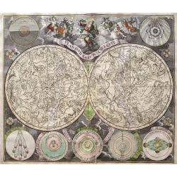
Planisphaerium Coeleste.
A hihgly decorative double hemisphere celestial chart, centered on the North and South Poles, with seven smaller circular diagrams illustrating the theories of Tycho, Pto...
Date: Augsburg, 1730-1760
Selling price: ????
Please login to see price!
Sold in 2016
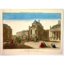
L'Exterieur de la Chapelle du Chateau de Versailles, du Cote de la Cour.
So-called optical print of The Exterior of the Chapel of the Chateau de Versailles, the Court of Approval (lOUIS XIV'S CHAPEL) by Basset.Basset was a well-known publisher...
Date: Paris , 1760
Selling price: ????
Please login to see price!
Sold in 2016
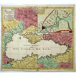
Nova Mappa Maris Nigri et Freti Constantino Politani. . .
Decorative and uncommon map the Black Sea region.
Date: Augsburg, ca. 1760
Selling price: ????
Please login to see price!
Sold in 2018
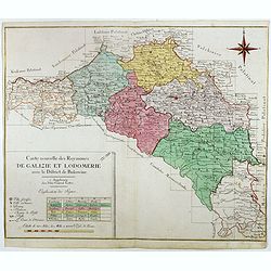
Carte nouvelle des Royaumes de Galizie et Lodomerie avec le district de Bukowine.
Uncommon map showing parts of present-day Poland and Ukraine. Including the Kingdom of Galicia and Lodomeria, which was a crown land of the Habsburg Monarchy that was acq...
Date: Augsburg, ca. 1760
Selling price: ????
Please login to see price!
Sold in 2016
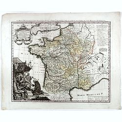
La France bénédictine, ou carte générale des abbayes . . .
This uncommon map is showing France with its provinces according to the Order of Saint Benedict. Larghe title cartouche, lower left, showing the King of France, who is si...
Date: Nuremberg, 1760
Selling price: ????
Please login to see price!
Sold in 2019
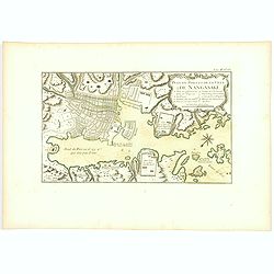
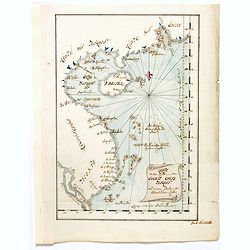
Plan du port et de la ville de Nangasaki.
Attractive and well detailed plan of Nagasaki, large title cartouche with reference key to principal points of interest. Deshima is central to the map.Jacques Nicolaas Be...
Date: Paris, 1760
Selling price: ????
Please login to see price!
Sold in 2018
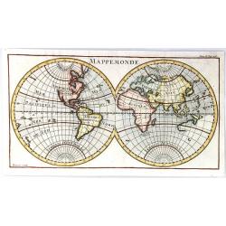
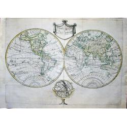
Mappemonde
A simple double hemisphere map of the world. Inconsistencies with current maps include: the eastern coast of Australia and New Zealand are not yet completely formed; the ...
Date: Paris, ca. 1760
Selling price: ????
Please login to see price!
Sold in 2021
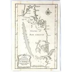
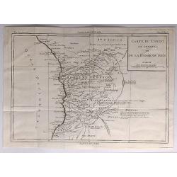
Carte de la Coste Occidentale D'Africa Depuis le Cap Blanc Jusqu'a Tanit
This map depicts the west coast of Africa along Mauritania, detailing the area around the Bay of Arguin.Islands, capes, and important towns surrounding the bay are labele...
Date: Paris, 1760
Selling price: ????
Please login to see price!
Sold in 2017
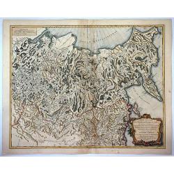
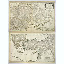
Partie orientale de L'Empire de Russie en Asie ...
A detailed map of eastern Russia that was published in the "Atlas Universel". The map extends from Kamchatka to Obskaya Guba and included Lake Baikal. Detail ex...
Date: Paris , 1760
Selling price: ????
Please login to see price!
Sold in 2017
A Chart of the Channel in the Phillippine Islands . . .
Large detailed chart of the Islands of the Philippines from the English edition of Anson's Voyages. One of the most detailed charts of the Philippines of the era. Shows I...
Date: Augsburg 1760
Selling price: ????
Please login to see price!
Sold in 2018
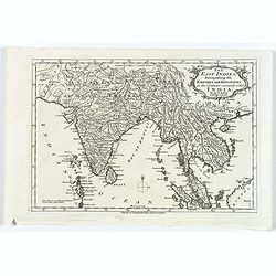
The East Indies, distinguishing the Empires and Kingdoms on the Continent commonly call'd India.
A typical mid eighteenth century mid-sized French map of the East Indies showing India, Tibet, Burma, Siam, Cambodia, Laos and down to Malaysia.Semi-decorative title cart...
Date: Paris, ca. 1760
Selling price: ????
Please login to see price!
Sold in 2017
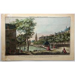
Vue Perspective du Koningsplein au Reguliers Touring, ou Tour de la Monnoye, a Amsterdam.
A pleasing vue perspective featuring a river in Amsterdam. Published by Chez Maillet in Paris in 1760. After an model by Jan de Beijer (1703-1780).In the eighteenth and ...
Date: Paris, 1760
Selling price: ????
Please login to see price!
Sold in 2018
Carte du Congo en General ou de la Basse Guinnee.
A detailed map of the west coast of Africa, from Gabon to Namibia, and featuring the Congo. With detail and notations concerning recent explorations. Title in a plain blo...
Date: Paris, 1760
Selling price: ????
Please login to see price!
Sold in 2017
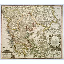
Graecia Nova et Mare Aegeum l'Archipelagus .. Morea..
An attractive map of Greece, with a beautiful title cartouche, and an explanation table and mileage scales filling the lower corners of the map.T.C. Lotter married M. Seu...
Date: Augsburg, 1760
Selling price: ????
Please login to see price!
Sold in 2017
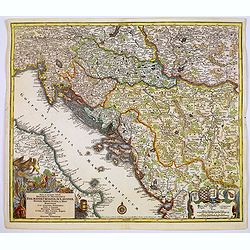
Nova et accurata.. Dalmatiae, Croatiae, Sclovoniae, Bosniae. . .
A finely engraved and large detailed map including the western part of the river Donau. Two decorative cartouches adorn the lower corners of the map. One with coats of ar...
Date: Augsburg, 1760
Selling price: ????
Please login to see price!
Sold in 2017
Troisieme partie de la Carte d'Europe conenant ..Russie, Pologne et la Hongrie, la Turquie. . .
A large 2 sheet map, by French cartographer d'Anville, measuring 1030 x 1620 mm when joined together, showing most of Eastern Europe, parts western Russia and parts of th...
Date: Paris, ca. 1760
Selling price: ????
Please login to see price!
Sold in 2017
Karte von den Küsten von Cochin China, Tunquin und einem Theile der chinesischen Küste
Manuscript map of the coast of Northern Vietnam up to coast of the south Chinese coast below there the island of Hainan. In upper right corner the region of Canton, Macao...
Date: Germany, ca. 1760
Selling price: ????
Please login to see price!
Sold in 2020
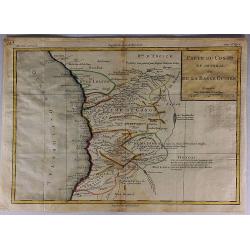
Carte du Congo en General ou de la Basse Guinee.
A detailed map of the west coast of Africa, from The Gabon to Namibia. Filled with detail and notations concerning recent explorations. Title in block style.Louis Brion d...
Date: Paris, 1760
Selling price: ????
Please login to see price!
Sold in 2017
Plan de l'Enceinte de la Ville de Nan-King ou Kyang-Ning-Fou (and) Plan de la Ville de Su-Tcheou-Fou.
Two maps on a single sheet, depicting major Chinese Cities. The plan of the left shows Nanking and its fortifications. The plan on the right shows Su-Tcheou-Fou or Su-Che...
Date: Paris, 1760
Selling price: ????
Please login to see price!
Sold in 2018
America Septentrionalis concinnata...
A copperplate colored map of the north east America, that shows California as an island, after the foundation map by de L'Isle published in 1700, which was the first map ...
Date: Augsburg, 1760
Selling price: ????
Please login to see price!
Sold in 2017
Prospect und Grund-riss der Kayserl. Residenz-stradt wien mit negst aligender . . .
Decorative town plan of Vienna with surrounding area. In lower part a fine panoramic view with Danube in the foreground.
Date: Nuremberg , ca. 1760
Selling price: ????
Please login to see price!
Sold in 2020
Nova et accurata.. Dalmatiae, Croatiae, Sclovoniae, Bosniae. . .
A finely engraved, large detailed map that includes the western part of the river Donau. Two decorative cartouches adorn the lower corners of the map. One of these shows ...
Date: Augsburg, 1760
Selling price: ????
Please login to see price!
Sold in 2018
Mappa Mundi ou carta geografica de Europa, Africa, America e Azia.
Unrecorded very large double hemisphere world map from the second half of the XVIII century. The map closely resembles in its geographical features that of the Parisian p...
Date: Portugal, ca 1760
Selling price: ????
Please login to see price!
Sold in 2019
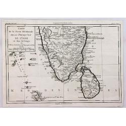
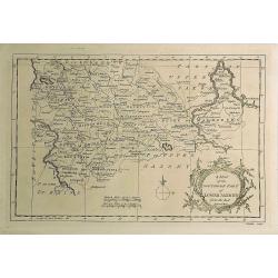
Carte de la Partie Meridionale de la Presqu'ile de l'inde en deca du Gange.
A quaint map of southern India and Ceylon by Brion de la Tour. From Brunet's Histoire Universelle, depuis le commencement du monde jusqu'a present by Brion de la Tour.Lo...
Date: Paris, 1760
Selling price: ????
Please login to see price!
Sold in 2018
America septentrionalis oder Mitternachtiger theil von America bestehend in Neu Brittania, Canada, Neu Engeland, Neu Schotland, Neu Jorck, Pensylvania, Carolina, Florida, Georgien. . .
A rare German map of the East Coast of North America. Shows the British Colonies at the end of the Franco-Indian War, and extends from Newfoundland until Florida, and wes...
Date: Augsburg, ca 1760
Selling price: ????
Please login to see price!
Sold in 2018
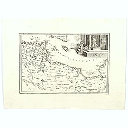
Africa Propria.
A map showing the North African coastlines of Tunisia and Libya, also to the north are a part of Sicily and the island of Malta and the surrounding smaller islands. The m...
Date: London ca. 1760
Selling price: ????
Please login to see price!
Sold in 2018
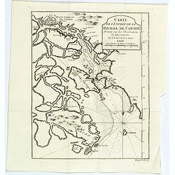
Carte de l'entrée de la Riviere de Canton. . .
Bellin's map of the mouth of the Canton River, from the island of Macao, to Canton itself. Shows the future site of Hong Kong (Sinn-gan-hein).The city of Canton is divide...
Date: Paris, 1760
Selling price: ????
Please login to see price!
Sold in 2020
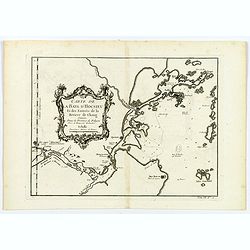
Carte de la Baye d'Hocsieu. . .
An interesting map showing the mouth and estuary of the Chiang River in southwest China, opposite Taiwan (Formosa) by Prevost, after Bellin. It shows the modern day Chine...
Date: Paris, ca 1760
Selling price: ????
Please login to see price!
Sold in 2020
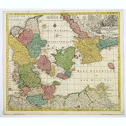
Daniae Regnum cum Ducatu Holsatiae et Slesvici. . .
An attractive map of Denmark by the German cartographer Tobias Lotter. The map also incorporates parts of northern Germany, including Schleswig Holstein, and the southern...
Date: Augsburg, 1760
Selling price: ????
Please login to see price!
Sold in 2020
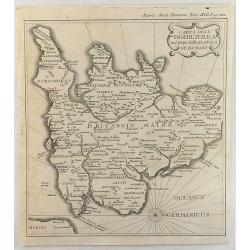
Carta Dell' Inghilterra nel Tempo della Decandenz a de Romani.
A detailed, fine and unusual ca 1760 Charles Rollin copper engraved historical map of England & Wales at the time of the Roman Domination. The map provides good topog...
Date: Paris, 1760
Selling price: ????
Please login to see price!
Sold in 2019
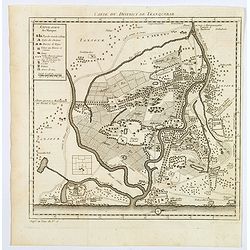
Carte du District de Tranquebar.
A lovely detailed map of the area around Tranquebar (now Tharangambadi), on the Coromandel coast. It was an early Danish Trading Colony in the modern Indian state of Tami...
Date: Paris ca 1760
Selling price: ????
Please login to see price!
Sold in 2020
Africa Secundum legitimas Projectionis Sterographicae regulas. . .
Johann Matthias Haas's revision J.B. Homann's 1715 map of Africa, augmented to include important cartographic developments as recorded by Guillaume Delisle and D'Anville....
Date: Nuremberg, ca 1760
Selling price: ????
Please login to see price!
Sold in 2020
A Map of the Southern Part of Lower Saxony. . .
A magnificent copper engraved map of the southern part of Lower Saxony or Hanover, Germany engraved by George Rollos, and published by J. Coote in London in 1760. It fea...
Date: London, 1760
Selling price: ????
Please login to see price!
Sold in 2019

