Browse Listings in Europe > Scandinavia
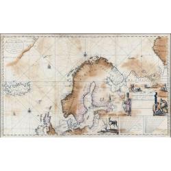
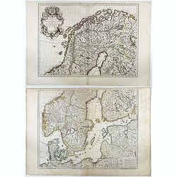
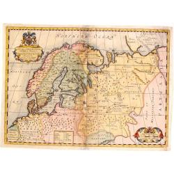
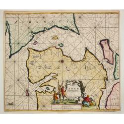
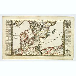
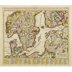
Nieuwe Paskaart Inhoudende t'Noorder deel van Europa sijnde seer Dienstigh voor de Groenlandse en Moscovise Scheepvaard.
A very large, exceptionally rare, early navigation chart of Scandinavia by van Keulen, with highly decorative hunting scenes. The chart is based on Mercator projection. G...
Date: Amsterdam, 1701
Selling price: ????
Please login to see price!
Sold in 2022
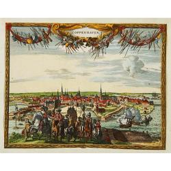
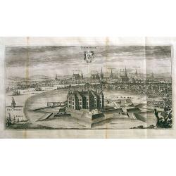
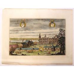
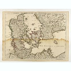
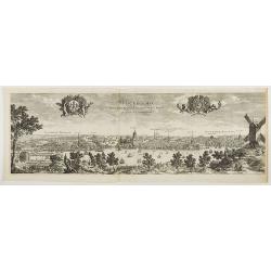
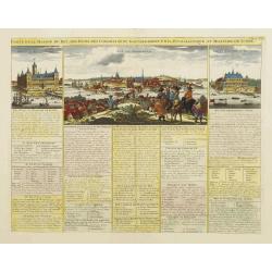
Coppenhaven.
Attractive view of the city and the port of Copenhagen. Very decorative title cartouche on the upper part.
Date: Amsterdam 1702
Selling price: ????
Please login to see price!
Sold
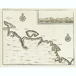
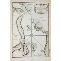
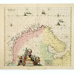
(Kegor.)
Uncommon map of part of the coast along the Barents Sea with the island of Kildin, offshore of the river and town of Cola (Murmansk). Originally made to illustrate Willem...
Date: Amsterdam, E. Roger, 1702
Selling price: ????
Please login to see price!
Sold in 2012
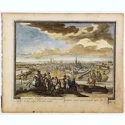
Koppenhaven, de hooftsadt van Denemarken. .
Nice panoramic view of Copenhagen. From Schenk's "Hecatompolis sive Totius Terrarum Oppida Nobiliora Centrum...", a collection of 100 views, dedicated to the 14...
Date: Amsterdam, 1702
Selling price: ????
Please login to see price!
Sold in 2016
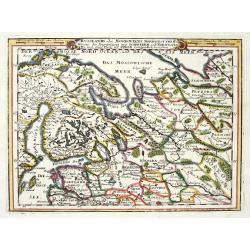
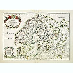
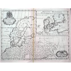
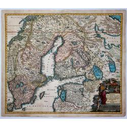
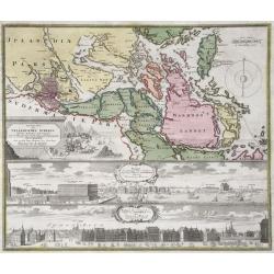
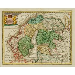
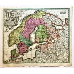
RUSSLANDS ODER MOSKOVIENS NORD-WEST THEIL...SCHWEDEN UND NORWEGEN...POLEN...
Very decorative map from Bodenehr's "Atlas curieux" published in Augsburg. The map shows parts of Norway, Sweden, Finland, the Baltic states and Russia in gre...
Date: Augsburg c1704
Selling price: ????
Please login to see price!
Sold in 2009
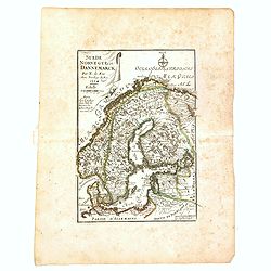
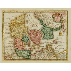
Suède, Norvège et Dannemarck.
An interesting small map of Scandinavia by Nicolas de Fer. From his rare "Petit et Nouveau Atlas". The first edition was published in 1697 and was republished i...
Date: Paris, 1704
Selling price: ????
Please login to see price!
Sold in 2017
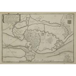
Copenhague ...
Charming bird's-eye plan of the fortification of the city of Copenhagen.Nicolas de Fer held the title of Geographer at Louis XIV's court. He was one of the most prolific ...
Date: Paris, 1705
Selling price: ????
Please login to see price!
Sold in 2011
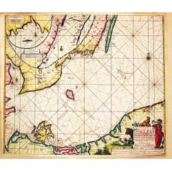
Le Sund ou Detroit du Sond.
Map of the Baltic sea, from "Atlas Curieux", printed in Paris.
Date: Paris, 1705
Selling price: ????
Please login to see price!
Sold in 2012
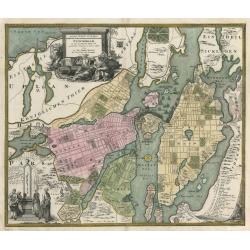
Carte des Courones du Nord Dediee Autres Puissant et tres Invincible Prince Charles XII Roy de Suede, des Gots et des Vandales
This is the top half of a two-part map of the larger Scandinavia/Russia region. This detailed map depicts Norway, Sweden, and Finland's northern areas and the Gulf of Bot...
Date: Paris, 1706
Selling price: ????
Please login to see price!
Sold in 2010
Norrkiöping.
Rare view of Norrköping in Sweden, with its "Star Fort" before it was destroyed during the Russian attack in 1719. Published by Erik Dahlberg. Highly detail...
Date: Stockholm, 1706
Selling price: ????
Please login to see price!
Sold in 2012
![Carte des Courones du Nord. [2 sheets]](/uploads/cache/41938-250x250.jpg)
Carte des Courones du Nord. [2 sheets]
Two-sheet map of Denmark, Sweden, Finland and the Baltic states with the address : "Carte des Courones du Nord. Chez l’Auteur, Rue des Canétes prés St. Sulpice. ...
Date: Paris, 1706
Selling price: ????
Please login to see price!
Sold in 2025
![Antique map of Scandinavia] Carte des Courones du Nord.](/uploads/cache/82019-250x250.jpg)
Antique map of Scandinavia] Carte des Courones du Nord.
[Antique map of Scandinavia] 'Carte des Courones du Nord', by Guillaume de l' Isle (1675-1724), a Royal Geographer. He was the most influential cartographer of the first ...
Date: Paris, 1706
Selling price: ????
Please login to see price!
Sold in 2020
La Scandinavie et les Environs où sont les Royaumes.
Fine map of Scandinavia and the Baltic States with figurative armorial cartouche and small scale of miles. Engraved by Cordier.
Date: Paris, 1708
Selling price: ????
Please login to see price!
Sold in 2009

La Scandinavie et les Environs où sont les Royaumes.
Fine map of Scandinavia and the Baltic States with figurative armorial cartouche and small scale of miles. Prepared by Sanson and published by Hubert Jaillot.Engraved by ...
Date: Paris, dated 1708
Selling price: ????
Please login to see price!
Sold in 2010
La Scandinavie et les Environs où sont les Royaumes.
Fine map of Scandinavia and the Baltic States with figurative armorial cartouche and small scale of miles. Prepared by Sanson and published by Hubert Jaillot.Engraved by ...
Date: Paris, dated 1708
Selling price: ????
Please login to see price!
Sold in 2012
Carte des Courones du Nord.
Denmark, Sweden, Finland and the Baltic states are included.
Date: Amsterdam, 1708
Selling price: ????
Please login to see price!
Sold in 2016
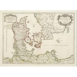
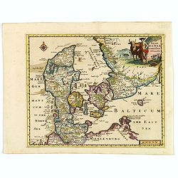
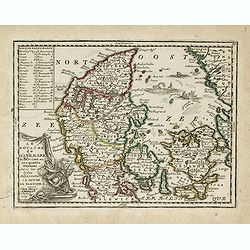
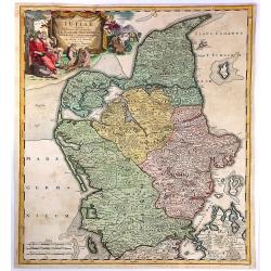
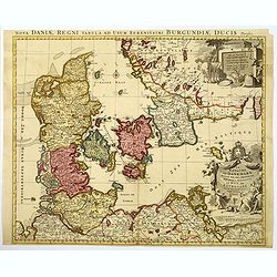
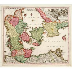
Le Royaume de Danemark subdivisé en ses Principales Provinces..
Handsome map of Denmark and part of Sweden. The map is extremely detailed with rivers, forests, cities and villages. The map is adorned with a striking cartouche flanked ...
Date: Paris, 1709
Selling price: ????
Please login to see price!
Sold in 2008
Idingsta.
Fine hand-colored, copper engraving of Idingsta, Sweden.Jan van den Aveele or Aveelen (1650 - 1727) was a Dutch etcher and engraver. With compatriot Willem Swidde, he mad...
Date: Stockholm, 1709
Selling price: ????
Please login to see price!
Sold in 2013
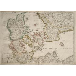
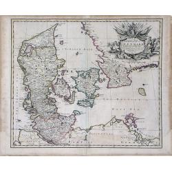
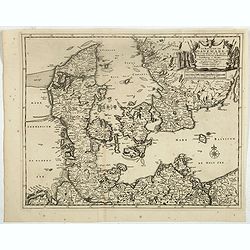
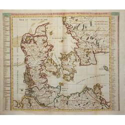
Carte du Royaume de Danemarc
Detailed map of Denmark, also including southern Sweden and northern Germany, showing the city of Copenhagen (Copenhague).
Date: Paris, 1710
Selling price: ????
Please login to see price!
Sold in 2010
Carte du Royaume de Danemarc.
Guillaume de l'Isle's (1675-1726) well deserved reputation as one of the foremost geographers of the 18th century meant that his maps were influential for many years afte...
Date: Paris, 1710
Selling price: ????
Please login to see price!
Sold in 2022
Sweden Corrected from the Observations Communicated to the Royal Society in London and the Royal Academy in Paris. . .
A large-scale general map of Scandinavia. In addition to Sweden, it shows Norway, Denmark and Finland. The new city of St. Petersburg (founded 1703) is shown at the head ...
Date: London, 1710
Selling price: ????
Please login to see price!
Sold in 2020
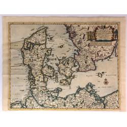
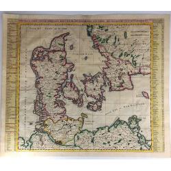
Regni Daniae accuratissima delineatio.
A delightful, attractive small map of Denmark by Philipp Cluver, published in the early years of the eighteenth century. The map has nice, eye catching coloring, enhanced...
Date: London, 1711
Selling price: ????
Please login to see price!
Sold in 2018
Le Royaume de Danemark Avec Une Partie de la Suede.
A detailed map of Denmark and southwestern Sweden, published by Van der Aa in his “Le Nouveau Theatre du Monde . . . .” This bold map of Denmark and southern Sweden s...
Date: Leiden, 1713
Selling price: ????
Please login to see price!
Sold in 2018
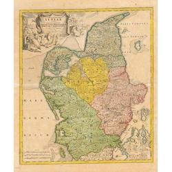
Tabula Generalis Jutiae.
Johan Baptist Homann (1663-1724). Outstanding German cartographer. Founder of the Homann publishing house. After the death of the son Johann Christoph, the firm continued...
Date: Nurnberg, 1714
Selling price: ????
Please login to see price!
Sold
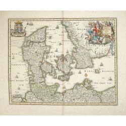
A New Map of Denmark, Norway, Sweden & Moscovy.
A striking decorative map of Skandinavia with Russian Europe added. The cities in Germany and Poland are shown as being part of Sweden and Denmark. Nova Zembla is shown a...
Date: London, 1714
Selling price: ????
Please login to see price!
Sold in 2015
Nouvelle Carte Geographique du Royaume de Dannemarck avec une Table des Villes les Plus Remarquables.
An impressive engraving from Chatelain’s celebrated encyclopedia, “Atlas Historique”. This is a lovely impression of Chatelain’s large map of Denmark. The map cov...
Date: Amsterdam, 1714
Selling price: ????
Please login to see price!
Sold in 2017
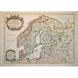
Nouvelle Carte de Scandinavie ou des Etats du Nord dressee sur les Observations. . .
Henri Chatelain's large format decorative map of Scandinavia featuring no less than 34 provincial heraldic shields, 17 on each flank of the map, together with tables of t...
Date: Amsterdam, ca 1714
Selling price: ????
Please login to see price!
Sold in 2018
A New Map of Ancient Scandinavia. . .
A scarce map extending from northern Germany until Russia with old place names. Including Scandinavia and the Baltic. An inset map shows Denmark and southern Sweden in mo...
Date: Oxford, ca 1701-1714
Selling price: ????
Please login to see price!
Sold in 2018
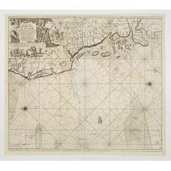
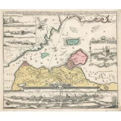
Paskaart vande West Kust van Jutland Van Busem tot aen 't Jutlandsche Riff.
A fine chart of the west coast of Schleswig-Holstein with the North Frisian Islands, Pelworm to Sylt and the west coast of Jutland. With a very large title-cartouche.From...
Date: Amsterdam 1715
Selling price: ????
Please login to see price!
Sold
Paskaart van t' Schager-Rak Soo 't by de Oost-vaerende Zee Luyden gemeenlyk bezylt wordt.
The successful van Keulen firm published charts, pilot guides and sea-atlases for over 2 centuries. Founded by Johannes van Keulen, his son Gerard led the firm to its zen...
Date: Amsterdam, 1715
Selling price: ????
Please login to see price!
Sold
Paskaart Voor een gedeelte van de Oost-Zee. Beginnende van Schenkkenes tot aan Stokholm.
The successful van Keulen firm published charts, pilot guides and sea-atlases for over 2 centuries. Founded by Johannes van Keulen, his son Gerard led the firm to its zen...
Date: Amsterdam, 1715
Selling price: ????
Please login to see price!
Sold
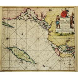
Pascaart Om door de Sond En de Droogen te Seylen Stekkende van Kol tot Meun.
The successful van Keulen firm published charts, pilot guides and sea-atlases for over 2 centuries. Founded by Johannes van Keulen, his son Gerard led the firm to its zen...
Date: Amsterdam, 1715
Selling price: ????
Please login to see price!
Sold
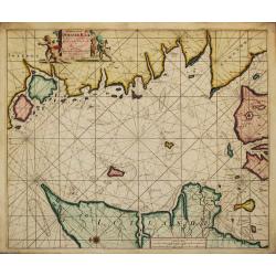
Finmarchae et Laplandiae Maritima. / Nieuwe Pascaert vande Kusten Finmarcken en Lapland Streckende van Dronten tot Archangel.
An eye-catching chart of Barents Sea and White Sea (with Archangelsk) with the coast of Norway, Lapland and peninsula Kola.. Coastal cities, bodies of water and islands a...
Date: Amsterdam, 1715
Selling price: ????
Please login to see price!
Sold in 2012
Stockholmia metropolis regni Sueciae et sedes regia qua parte . . .
Very decorative etching of Stockholm by the Parian master engraver and etcher Perelle (1638 - 1695). The title between two elegant cartouches decorated with cherubs, the ...
Date: Paris, 1715
Selling price: ????
Please login to see price!
Sold in 2018
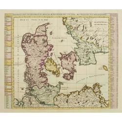
Paskaart Voor een gedeelte van de Oost-Zee. Beginnende van Valsterborn tot Schenkkenes.
A sea chart of the southwest part of the Baltic with two insets showing the coast between Kristianstad and Calmer, and the ports of 'Selfborgh, Boetekolen Rottenbuy'....
Date: Amsterdam, 1715
Selling price: ????
Please login to see price!
Sold in 2021
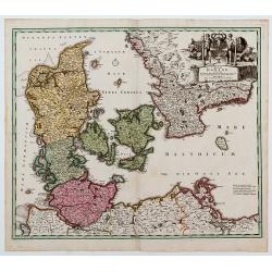
Der Nordischen Konigreiche Sud-West Theil.
An attractive map of the southwest portion of the Nordic kingdom, showing southern Sweden and Denmark, a tiny tip of southern Norway, plus some of the northern German and...
Date: Augsberg, 1716
Selling price: ????
Please login to see price!
Sold in 2021
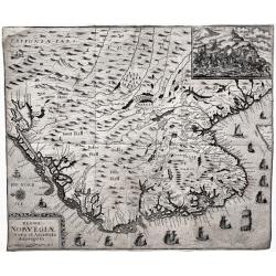
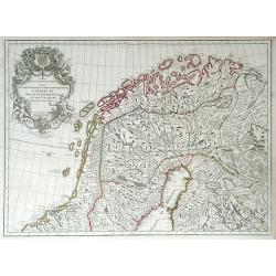
Regni Norvegiæ Nova et Accurata descriptio.
A very rare, decorative map of Norway with inset battle scene and many ships sailing along the coast. The map was included in the fall 1716 issue of Relationis Historicæ...
Date: Frankfurt, 1716
Selling price: ????
Please login to see price!
Sold in 2020
Carte de l'Etat du Royaume de Dannemarck...
Views of the Kingdom of Denmark and various observations about the history and government of this Kingdom.The map shows three views: Friderichsbourg, Copenhagen and Berge...
Date: Amsterdam, 1718
Selling price: ????
Please login to see price!
Sold in 2017
Estats de la Couronne de Suede dans la Scandinavie, ou sont Suede, Gotlande, Lapponie Suedoise, Finlande, Ingrie et Livonie. Subdivisees en leurs Provinces..
Lovely small map centered on Finland, with Sweden and much of Norway to the west, Frontieres de Moscovie to the east.Depiction of lakes, rivers and coastline reminiscent ...
Date: Paris, 1719
Selling price: ????
Please login to see price!
Sold in 2009
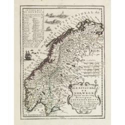
Le Royaume de Norwege Divisé en ses cinq Principaux Gouvernements..
Lovely small map of Norway, with much of Sweden to the East, vessel and sea monsters in the Norwegian Sea.It shows a text table in the upper left corner containing the na...
Date: Paris, 1719
Selling price: ????
Please login to see price!
Sold in 2017
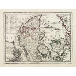
Le Royaume de Danemark Subdivisée en ses quatre Dioceses..
Lovely small map of Denmark, with decorative title cartouche.It shows a text table in the upper left corner containing the names of local rulers.From Le Nouveau et Curieu...
Date: Paris 1719
Selling price: ????
Please login to see price!
Sold
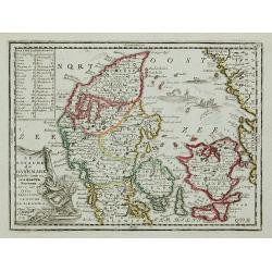
Le Royaume de Danemark Subdivisée en ses quatre Dioceses ...
Lovely small map of Denmark, with decorative title cartouche.It shows a text table in the upper left corner containing the names of local rulers.From Le Nouveau et Curieu...
Date: Paris, 1719
Selling price: ????
Please login to see price!
Sold in 2011
A New Map of the Kingdom of Denmark with the Dutchy of Holstein & c. According to the Newest Observations. . .
A finely detailed map of Denmark with lower Sweden by John Senex. Shows the rivers, marshes, lakes, cities, villages and mountains of the region. A beautiful, illustrated...
Date: London, 1719
Selling price: ????
Please login to see price!
Sold in 2010
Le Royaume de Danemark Subdivisée en ses quatre Dioceses..
Lovely small map of Denmark, with decorative title cartouche.It shows a text table in the upper left corner containing the names of local rulers.From Le Nouveau et Curieu...
Date: Paris, 1719
Selling price: ????
Please login to see price!
Sold in 2015
Estats de la Couronne de Suede dans la Scandinavie, ou sont Suede, Gotlande, Lapponie Suedoise, Finlande, Ingrie et Livonie. Subdivisees en leurs Provinces..
Lovely small map centered on Finland, with Sweden and much of Norway to the west, Frontieres de Moscovie to the east.Depiction of lakes, rivers and coastline reminiscent ...
Date: Paris, 1719
Selling price: ????
Please login to see price!
Sold in 2019
Le Royaume de Danermark . . .
Decorative map of Denmark. This well executed engraving was published in 1729 and 1727 by Pieter van der AA, in Leiden in "Les Voyages tres-curieux et tres-renommez ...
Date: Leiden, 1719
Selling price: ????
Please login to see price!
Sold in 2019
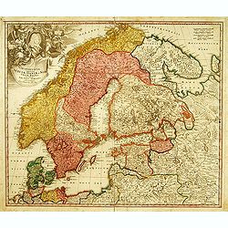
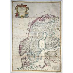
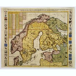
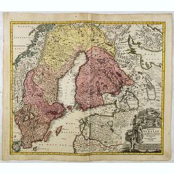
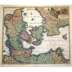
Scandinavia complectens Sueciae, Daniae & Norvegia.
Johann Baptist Homann's well-engraved map has a large decorative cartouche. Detailed map of Scandinavia. Johann Baptist Homann (1663-1724) was a German engraver and publi...
Date: Nuremberg, 1720
Selling price: ????
Please login to see price!
Sold
Carte Genealogique pour conduire a l' histore des Rois du Nord, la Carte de leurs etats, leurs Armes &tc. / nouvelle cart du Royaume de Suede. / Carte du Royaume de Gothie.
Henri Abraham Chatelain was a Amsterdam-based geographer and publisher. His main product is the 'Atlas Historique et Méthodique', in seven volumes, published between 171...
Date: Amsterdam, 1710-1720
Selling price: ????
Please login to see price!
Sold
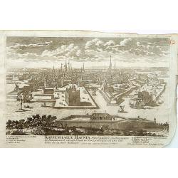
Koppenhage Hafnia Ville capitale du Royaume de Danemark.
A very RARE panoramic view of the city of Copenhagen, with a numbered legend in both lower corner.The plate is numbered in red pencil in upper right corner.Engraved by Pi...
Date: Paris 1690-1720
Selling price: ????
Please login to see price!
Sold
Nouvelle Carte Geographique du Royaume de Dannemarck avec une table des villes les plus remarquables.
Map of Denmark with a key table to the towns on both sides.Zacharie Chatelain (d.1723) was the father of Henri Abraham (1684-1743) and Zacharie Junior (1690-1754).They wo...
Date: Amsterdam, ca. 1720
Selling price: ????
Please login to see price!
Sold
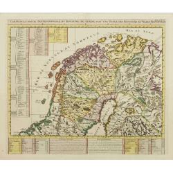
Carte de la Partie Septentrionale du Royaume de Suede?
Map of the northern part of Scandinavia. It covers the area straddling Norway, Sweden, Finland and Russia.Zacharie Chatelain (d.1723) was the father of Henri Abraham (168...
Date: Amsterdam, ca. 1720
Selling price: ????
Please login to see price!
Sold
Carte de la Partie Meridionale du Royaume de Suede?
Map of the southern part of Scandinavia with letter key at the bottom.Zacharie Chatelain (d.1723) was the father of Henri Abraham (1684-1743) and Zacharie Junior (1690-17...
Date: Amsterdam, ca. 1720
Selling price: ????
Please login to see price!
Sold
Carte de la Maison du Roi, des Etats.. de Suede.
This impressive engraving is a wonderful example of Chatelain?s elegant plates. Ornamented with 3 vignettes: Palais du Roi de Suede, Vuë de Stockholm, Vuë du château d...
Date: Amsterdam, ca. 1720
Selling price: ????
Please login to see price!
Sold in 2009
Nouvelle Carte Geographique du Royaume de Dannemarck avec une table des villes les plus remarquables.
Map of Denmark with a key table to the towns on both sides.Zacharie Chatelain (d.1723) was the father of Henri Abraham (1684-1743) and Zacharie Junior (1690-1754).They wo...
Date: Amsterdam, ca. 1720
Selling price: ????
Please login to see price!
Sold in 2011
SCANDINAVIA complectens SUECIAE, DANIAE, & NORVEGIAE, REGNA. ex Tabula Joh. Baptista Homann.
A large, detailed map showing all of Scandinavia, including the Baltic region and parts of Russia. An attractive title cartouche decorates the upper left corner of the ma...
Date: Nurnberg, c.1720
Selling price: ????
Please login to see price!
Sold in 2013
Regni Sueciae in Omnes Suas Subjacentes.
Large, detailed, hand-colored map featuring Sweden, Finland, Eastern Russia and Northern Poland, Lithuania, Latvia & Estonia. Fine allegorical title cartouche with fo...
Date: Nuremberg, 1720
Selling price: ????
Please login to see price!
Sold in 2017
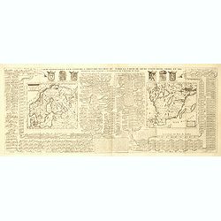
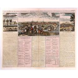
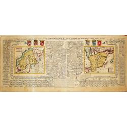
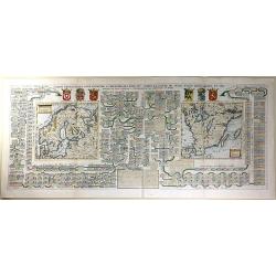
Carte généalogique pour conduire à l'histoire des rois du nord de la carte de leurs états, leurs armes et des remarques pour conduire à l'intelligence de l'histoire du nord.
Interesting sheet with a genealogical table of the Kingdoms of the Scandinavian countries with two small maps: Scandinavia and Southern Sweden, with descriptive French te...
Date: Amsterdam, 1720
Selling price: ????
Please login to see price!
Sold in 2018
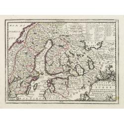
Regni Sueciae in omnes suas Subjacentes Provincias accurate divisi Tabula Generalis. . .
Johann Baptist Homann's well-engraved map of Scandinavia, the Baltic Sea, Lithuania, Latvia, Estonia, Curlandia, etc. with a large decorative title cartouche.Johann Bapti...
Date: Nuremberg, ca. 1720
Selling price: ????
Please login to see price!
Sold in 2016
Tabula Generalis Iutiae.
A spectacular and historically important map of the northern part of Denmark, that is called Jutland.It features a wonderful, oversized, decorative drape title cartouche ...
Date: Nuremberg, 1720
Selling price: ????
Please login to see price!
Sold in 2018
![[2 maps] Carte des Couronnes du Nord Dédiée au .... CHARLES XII, ROY](/uploads/cache/38418-250x250.jpg)
[2 maps] Carte des Couronnes du Nord Dédiée au .... CHARLES XII, ROY
A large two sheet map of the Baltic, Sweden and Norway by G. de Lisle. Delisle was an important French cartographer of the early 18th century. He held the position of Fir...
Date: Paris , ca. 1720
Selling price: ????
Please login to see price!
Sold in 2018
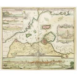
Accurate Vorstellung der Beruhmten Enge Zwischen der Nord und Ost See dur Sund Genant. . .Copenhagen. . .
A striking and a lovely copper engraved map of Copenhagen and the sound of Sund from Johann Bapt. Homann's "Grosser Atlas.", with original color to map, the vig...
Date: Nuremberg, ca 1720
Selling price: ????
Please login to see price!
Sold in 2019
Le Royaume de Danemark divise en ses Provinces. . .
This bold, striking map of Denmark and southern Sweden is engraved to highlight marshes, rivers, cities and towns, shoals and forests. The map is decorated with beautiful...
Date: Amsterdam, ca 1720
Selling price: ????
Please login to see price!
Sold in 2019
Regni Daniae- in quo sunt Ducatus Holsatia et Slesvicum Insulae Danicae provinciae Iutia Scania Bleringia.
Original hand-colored engraved map. (sheet size 53 x 62 cm.)
Date: Nuremberg, 1720
Selling price: ????
Please login to see price!
Sold in 2020
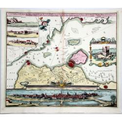
Accurate Vorstellung der Beruhmten Meer-Enge Zwischen der Nord und Ost See der Sund Genant, mit der herumligenden Gegend von Seeland und Schonen nebst der Koniglich-Danischen Haupt und Residentz Stadt Copenhagen...
Homann's map of the area between Copenhagen and Malmoe and the Sund Sound Showing the contiguous Danish & Swedish coastlines, centered on Copenhagen and Landscron. At...
Date: Nuremberg, ca. 1720
Selling price: ????
Please login to see price!
Sold in 2020
Accurate Carte der Uplandischen Scheren mid der Situation und Gegend umb die Konigl. Schwedische Haupt und Residentz Stadt Stockholm.
Johann Christoph Homann - Accurate Carte der Uplandischen Scheren - Nuremberg, ca. 1730. Sweden - Stockholm: Accurate map of the Upland skerries with the situation and ar...
Date: Nürnberg, ca 1720
Selling price: ????
Please login to see price!
Sold in 2021
Accurater Grundriß und Prospect Der Kön. Schwed. Reichs. u. Hauptstadt Stockholm
This superb early eighteenth century map of Stockholm in full original hand colour is from Homann’s Maior Atlas Superiore. The map depicts Stockholm as it was at the ...
Date: Nuremburg, 1720
Selling price: ????
Please login to see price!
Sold in 2023
Copenhagen
This map by Johann Homann depicts the city of Copenhagen and its environs from differing perspectives, as the city appeared in the early 18th century.There is evidence of...
Date: Nuremberg, 1720
Selling price: ????
Please login to see price!
Sold in 2023
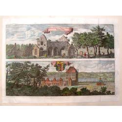
Rudera Sive Reliquia Templi et Monesteri Alfvastrae / Braaborg.
View of the ruins of the 12th century Cistercian monastery at Alvastra. Also, view of the palace at Braaborg. From Dahlbergh's "Suecia Aniqua et Hodierna". Feat...
Date: Stockholm, 1723
Selling price: ????
Please login to see price!
Sold in 2013
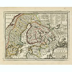
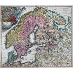
Sueciae Regnum cum vicinis Regionibus.
Uncommon map of Scandinavia. The originally colored title cartouche is surrounded by mythological figures. From Atlas Portatif.
Date: Nuremberg 1724
Selling price: ????
Please login to see price!
Sold
Daniae cum Serie Insularum?
Uncommon map of Denmark. The originally colored title cartouche is surrounded by mythological figures. From Atlas Portatif.
Date: Nuremberg 1724
Selling price: ????
Please login to see price!
Sold
Dania Jutia Holsatia, Scandia...
An attractive map of Denmark and adjacent coastlines. Includes elaborate cartouche and 2 coats of arms.Nice old coloring, drawn and engraved by Michael Kauffer.(inscripti...
Date: Nuremberg, 1724
Selling price: ????
Please login to see price!
Sold in 2012
Carte Généalogique Pour Conduire à l'Histoire des Rois du Nord de la Carte de Leurs Etats, Leurs Armes et des Remarques Pour Conduire à l'Intelligence de l'Histoire du Nord
A very detailed, and wonderfully colored, composite sheet, with a genealogical table of the Kingdoms of the Scandinavian countries, with two small maps: Scandinavia and S...
Date: Amsterdam, 1728
Selling price: ????
Please login to see price!
Sold in 2016
Synopsis Plagae Septentrionalis size Sueciae Daniae et Norwegiae Regn.
A superb 18th century original hand colored map of Scandinavia that extends to the east to include portions of Russia, the Baltic states, and the northern part of Germany...
Date: Vienna, 1728
Selling price: ????
Please login to see price!
Sold in 2019
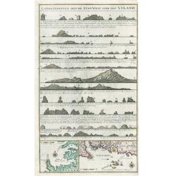
Landkenningen Aen De Zuyd West Syde Van Ysland
A rare cartographic work showing the coastlines of Iceland as they would appear from a ship at sea. The map title and descriptions of the coat are all done in Islandic la...
Date: Amsterdam, 1728
Selling price: ????
Please login to see price!
Sold in 2023
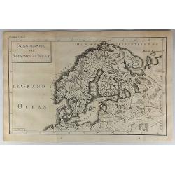
Scandinavie ou Royaume du Nort.
Striking map of Scandinavia. It is from “METHODE POUR ETUDIER L’HISTOIRE” by L’Abbe Lenglet du Fresnoy, published in Paris in 1729. The map is quite rare and is n...
Date: Paris, 1729
Selling price: ????
Please login to see price!
Sold in 2018
Daniae Regnum.
No text on verso.
Date: Nuremberg 1730
Selling price: ????
Please login to see price!
Sold
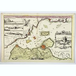
Accurate Vorstellung der Beruhmten... der Königlich Dähnischen..
A map of the Sond between Sweden and Denmark and its approach into Copenhagen. With a bird's eye-view of the Danish capital at the bottom.Surrounding the map are three in...
Date: Nuremberg , ca. 1730
Selling price: ????
Please login to see price!
Sold
Daniae Regnum cum Ducatu Holstiae et Slesvici.
Fine copper engraved map, hand-colored in outline & wash, featuring Denmark, with its neighbouring counties around the Baltic Sea and Schagerack. Map has a decorative...
Date: Augsburg, 1730
Selling price: ????
Please login to see price!
Sold in 2013
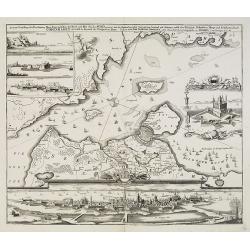
Accurate Vorstellung der Beruhmten ? der Königlich Dähnischen ?
A map of the Sond between Sweden and Denmark and its approach into Copenhagen. With a bird's eye-view of the Danish capital at the bottom.Surrounding the map are three in...
Date: Nuremberg , ca. 1730
Selling price: ????
Please login to see price!
Sold in 2009
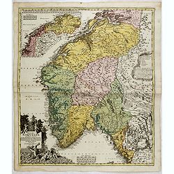
Norvegiae Accurata Tabula in qua Praefecturae quinque Generales. . .
Johann Baptist Homann's well-engraved map has a large decorative cartouche. Detailed map of Norway. The southern part of the country is the focus of the main map, while t...
Date: Nuremberg, ca. 1730
Selling price: ????
Please login to see price!
Sold in 2020
