Browse Listings in Europe > Scandinavia > Iceland
![[Lot of 19 leaves of Scandinavia, Greenland, Island]](/uploads/cache/48298-250x250.jpg)
[Lot of 19 leaves of Scandinavia, Greenland, Island]
Nineteen text leaves illustrated with wood block prints and maps relating to Scandinavia, Greenland and Island. From the 1552 Latin text edition of Münster's Cosmographia...
Date: Basel, 1552
Selling price: ????
Please login to see price!
Sold in 2022
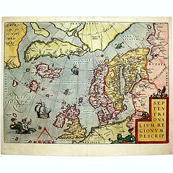
Septentrionalium Regionum Descrip.
1584 ORTELIUS, A. - Scandinavia, Iceland, Greenland and part of the North American continent, includes also the legendary islands of i.a. Drogeo, Frisland and Icaria.
Date: Antwerp, 1584
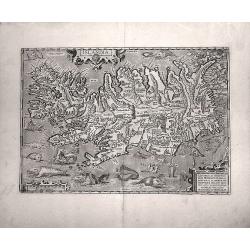
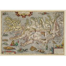
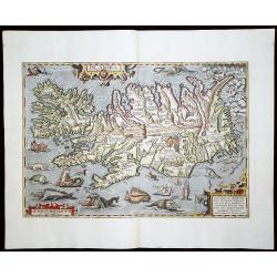
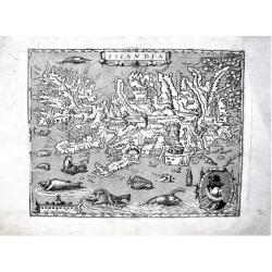
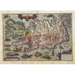
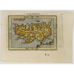
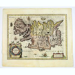
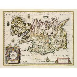
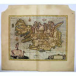
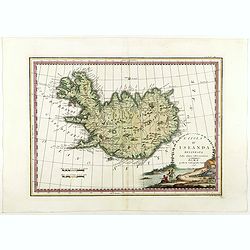
Islandia.
Probably the most famous (and among the most beautiful!) map of Iceland. On the south side an impressive collection of sea monsters. Polar bears on ice flows and volcanoe...
Date: Anwerp, ca 1590
Selling price: ????
Please login to see price!
Sold in 2016
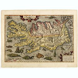
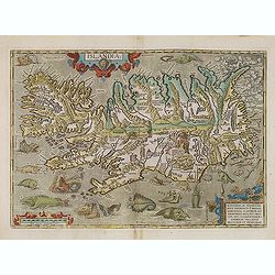
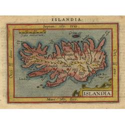
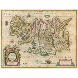
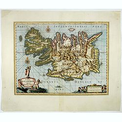
Islandia.
Perhaps the most famous map of Iceland. On the south side of the island a collection of all possible sea monsters is depicted. Polar bears on ice flows and volcanoes in t...
Date: Antwerp, 1591
Selling price: ????
Please login to see price!
Sold in 2015
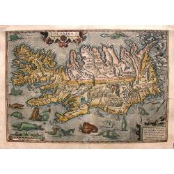
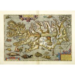
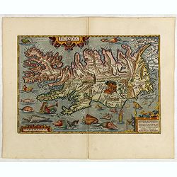
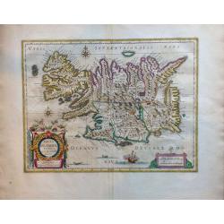
Islandia
From the 1591 German edition of the Theatrum (75 copies printed). Probably the most famous map of Iceland. The lower part of this map features a big collection of sea mon...
Date: Antwerp, 1591
Selling price: ????
Please login to see price!
Sold in 2015
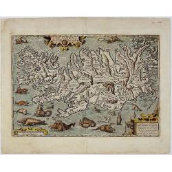
Islandia.
Perhaps the most famous map of Iceland. On the south side of the island a collection of all possible sea monsters is depicted. Polar bears on ice flows and volcanoes in t...
Date: Antwerp, 1592
Selling price: ????
Please login to see price!
Sold in 2009
Islandia.
Perhaps the most famous map of Iceland. On the south side of the island a collection of all possible sea monsters is depicted. Polar bears on ice flows and volcanoes in t...
Date: Antwerp, 1592
Selling price: ????
Please login to see price!
Sold in 2013
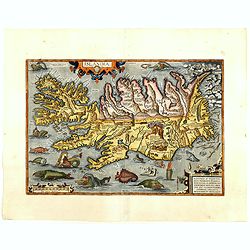
Islandia.
Perhaps the most famous map of Iceland. On the south side of the island a collection of all possible sea monsters is depicted. Polar bears on ice flows and volcanoes in t...
Date: Antwerp, 1592
Selling price: ????
Please login to see price!
Sold in 2011
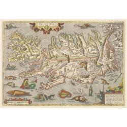
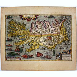
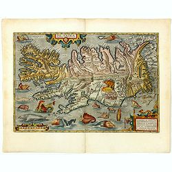
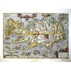
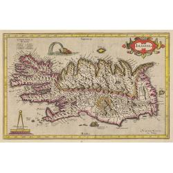
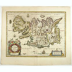
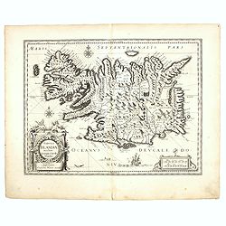
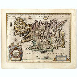
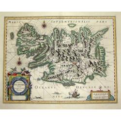
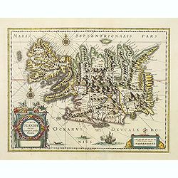
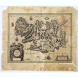
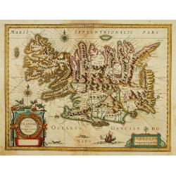
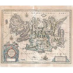
Islandia.
One of the most decorative atlas maps of all time was published by Abraham Ortelius in his atlas “Theatrum Orbis Terrarum”. The map depicts Iceland in truly remarkable de...
Date: Antwerp, 1592
Selling price: ????
Please login to see price!
Sold in 2018
Islandia.
Perhaps the most famous map of Iceland. On the south side of the island a collection of all possible sea monsters is depicted. Polar bears on ice flows and volcanoes in t...
Date: Antwerp, 1592
Selling price: ????
Please login to see price!
Sold in 2010
Islandia.
Perhaps the most famous map of Iceland. On the south side of the island a collection of all possible sea monsters is depicted. Polar bears on ice flows and volcanoes in t...
Date: Antwerp, 1592
Selling price: ????
Please login to see price!
Sold in 2012
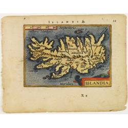
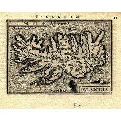
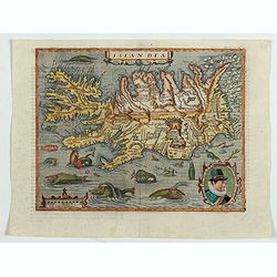
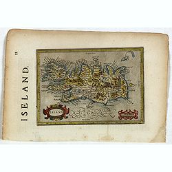
Islandia.
Miniature map Island. From the second series of miniature atlas of Ortelius' Epitome. A new series of pocket-size atlases was begun by Philip Galle in 1588. It seems that...
Date: Antwerp 1595
Selling price: ????
Please login to see price!
Sold
Islandia.
Perhaps the most famous map of Iceland. On the south side of the island a collection of all possible sea monsters is depicted. Polar bears on ice flows and volcanoes in t...
Date: Antwerp, 1595
Selling price: ????
Please login to see price!
Sold in 2015
Islandia.
Perhaps the most famous map of Iceland. On the south side of the island a collection of all possible sea monsters is depicted. Polar bears on ice flows and volcanoes in t...
Date: Antwerp, 1595
Selling price: ????
Please login to see price!
Sold in 2014
ISLANDIA.
Superb miniature map of Iceland. From the second series of the miniature atlas of Ortelius' Epitome. Shows the island with the main towns, mountains, rivers, and islands....
Date: Antwerp, 1595
Selling price: ????
Please login to see price!
Sold in 2009
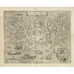
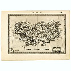
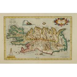
Islandia.
A fine, strong impression example of the famous Quad's map of Iceland. It can be considered a reduced version of Ortelius' "Islandia", the first realistic map o...
Date: Cologne, 1596
Selling price: ????
Please login to see price!
Sold in 2019
Islandia.
Perhaps the most famous map of Iceland. On the south side of the island a collection of all possible sea monsters is depicted. Polar bears on ice flows and volcanoes in t...
Date: Antwerp, 1598
Selling price: ????
Please login to see price!
Sold in 2018
Islandia.
Perhaps the most famous map of Iceland. On the south side of the island a collection of all possible sea monsters is depicted. Polar bears on ice flows and volcanoes in t...
Date: Antwerp, 1598
Selling price: ????
Please login to see price!
Sold in 2015
Islandia.
From the rare Dutch text edition of the Theatrum of which according to van den Broecke only 100 copies are printed.Perhaps the most famous map of Iceland. On the south si...
Date: Antwerp, 1598
Selling price: ????
Please login to see price!
Sold in 2016
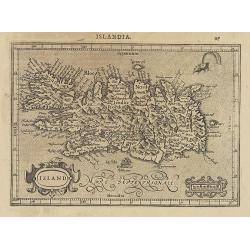
Islandia.
Quad's : reduced in size Ortelius´ map, of Iceland. With German text on verso, from Geographisch Handtbuch. Signed by the engraver Johan Bussemacher.Matthias Quad was on...
Date: Cologne, 1600
Selling price: ????
Please login to see price!
Sold in 2023
Islandia.
Quad's : reduced in size Ortelius´ map, of Iceland. With German text on verso, from Geographisch Handtbuch. Signed by the engraver Johan Bussemacher.Rare in original colo...
Date: Cologne, 1600
Selling price: ????
Please login to see price!
Sold in 2016
Islandia.
From the Latin text edition of the Theatrum of 1603 (according to van den Broecke only 300 copies printed). The most famous map of Iceland. On the south side a series of ...
Date: Antwerp, 1603
Selling price: ????
Please login to see price!
Sold in 2018
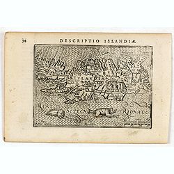
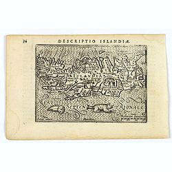
Descriptio Islandiae / Islandiae.
A rare miniature map of Iceland. With two sea monsters.First published in 1598 in his Caert-Thresoor, the plates were executed by the most famous engravers in Amsterdam, ...
Date: Amsterdam, Cornelis Claes, 1606
Selling price: ????
Please login to see price!
Sold in 2016
Islandia.
A superbly decorative miniature map of Iceland, published by Petrus Bertius, in Amsterdam at the beginning of the seventeenth century.This facinating map is littered with...
Date: Amsterdam, 1606
Selling price: ????
Please login to see price!
Sold in 2019
Island.
Map of Iceland from the first French-text edition of Jodocus Hondius' Atlas Minor.Shortly after the publication of the big folio-atlases the need was apparently felt for ...
Date: Amsterdam, 1608
Selling price: ????
Please login to see price!
Sold in 2014
ISLANDIA.
A very beautiful miniature map of Iceland based on Ortelius’ important map of the Island. Major cities named, the sea is stipple engraved, with a nice strap work title ca...
Date: Antwerp, 1609
Selling price: ????
Please login to see price!
Sold in 2019
Islandia.
Miniature map of Iceland with major cities named. The sea is stipple engraved. Strapwork title cartouche at lower right. Latin text on verso.
Date: Antwerp 1609
Selling price: ????
Please login to see price!
Sold
Islandia.
A very nice miniature map from Iceland showing a sea monster and exploding volcano. The map is a reduced version of Mercator's folio map of 1595. From an early edition of...
Date: Amsterdam, J. Janssonius, 1613
Selling price: ????
Please login to see price!
Sold in 2019
Islandia.
A very nice map from Iceland showing a sea monster and exploding volcano.Mercator was born in Rupelmonde in Flanders and studied in Leuven under Gemma Frisius, Dutch writ...
Date: Amsterdam, 1623
Selling price: ????
Please login to see price!
Sold in 2017
Islandia.
A very nice map from Iceland showing a sea monster and exploding volcano.Mercator was born in Rupelmonde in Flanders and studied in Leuven under Gemma Frisius, Dutch writ...
Date: Amsterdam, 1633
Selling price: ????
Please login to see price!
Sold in 2009
Islandia.
A very nice map from Iceland showing a sea monster and exploding volcano.Mercator was born in Rupelmonde in Flanders and studied in Leuven under Gemma Frisius, Dutch writ...
Date: Amsterdam 1633
Selling price: ????
Please login to see price!
Sold
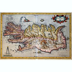
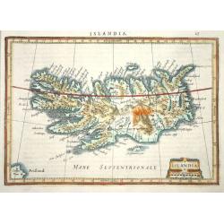
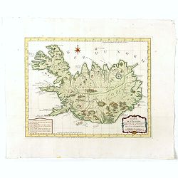
Tabula Islandiae Auctore Georgio Carolo Flandro.
Originally engraved for Jodocus Hondius II, at his death in August 1629 this map was, among 39 other copper plates, purchased by Willem Blaeu who deleted Hondius' name an...
Date: Amsterdam, 1634
Selling price: ????
Please login to see price!
Sold in 2017
Islandia
Delightful small map of Iceland, which is shown filled with mountains and volcanoes. Strapwork title and distance scale cartouche. Latin text on verso.
Date: Amsterdam, 1634
Selling price: ????
Please login to see price!
Sold
Tabula Islandiae Auctore Georgio Carolo Flandro.
Originally engraved for Jodocus Hondius II, at his death in August 1629 this map was, among 39 other copper plates, purchased by Willem Blaeu who deleted Hondius' name an...
Date: Amsterdam, 1634
Selling price: ????
Please login to see price!
Sold in 2017
Tabula Islandiae Auctore Georgio Carolo Flandro.
Originally engraved for Jodocus Hondius II, at his death in August 1629 this map was, among 39 other copper plates,purchased by Willem Blaeu who deleted Hondius' name and...
Date: Amsterdam, 1634
Selling price: ????
Please login to see price!
Sold in 2016
Island.
Map of Iceland from the rare English text edition of Jodocus Hondius' "Historia mundi, or, Mercator's Atlas. Containing his Cosmographical Description of the Fabrick...
Date: Michael Sparke and Samuel Cartwright, 1635
Selling price: ????
Please login to see price!
Sold in 2021
Tabula Islandiae. . .
This handsome map of Iceland was based on information from a Dutch navigator named Joris Carolus in about 1620. The map shows the influence of both versions of bishop Gud...
Date: Amsterdam, 1635
Selling price: ????
Please login to see price!
Sold in 2019
Tabula Islandiae
A fascinating and very beautiful map of Iceland from the Mercator / Hondius atlas based on the work of Juris Carolus. Carolus was a Dutch traveler who probably derived hi...
Date: Amsterdam, 1638
Selling price: ????
Please login to see price!
Sold
Tabula Islandiae.
A fine map of Iceland. Very attractive title cartouche in the lower left corner: around the island, a ship and two sea monsters are depicted.In spite of it's restorations...
Date: Amsterdam 1641
Selling price: ????
Please login to see price!
Sold in 2016
Tabula Islandiae. . .
Prepared by Georgio Carolo Flandrio. The map has a very decorative cartouche, and a very fine imprint.
Date: Amsterdam, 1639-1644
Selling price: ????
Please login to see price!
Sold in 2017
Tabula Islandiae..
Early imprint before Blaeu bought the copper plate for his atlas. Prepared by Georgio Carolo Flandrio. The map has a very decorative cartouche. Very fine imprint.
Date: Amsterdam, 1639-1644
Selling price: ????
Please login to see price!
Sold
Tabula Islandiae.
Based on information from Joris Carolus collected around 1620. Huge mountains and volcanoes in a labyrinth of fiords. It is embellished by title and distance cartouches, ...
Date: Amsterdam, 1645
Selling price: ????
Please login to see price!
Sold in 2017
Tabula Islandiae..
This handsome map of Iceland was based on information from a Dutch navigator named Joris Carolus in about 1620. The map shows the influence of both versions of bishop Gud...
Date: Amsterdam 1645
Selling price: ????
Please login to see price!
Sold
Tabula Islandiae
Nice copy of Blaeu's Iceland map. Latin text on verso.
Date: Amsterdam, 1662
Selling price: ????
Please login to see price!
Sold in 2009
Tabula Islandiae Auctore Georgio Carolo Flandro.
A fascinating and very beautiful map of Iceland by Willem Janszoon Blaeu based on the work of Juris Carolus.Carolus was a Dutch traveler who probably derived his 1620s ma...
Date: Amsterdam, ca. 1672
Selling price: ????
Please login to see price!
Sold in 2015
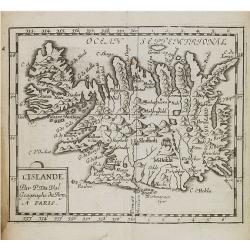
L'Islande.
Uncommon miniature map of Iceland from Pierre Duval's La Geographie Universeille. Following his Cartes de geographie in 1657, Pierre Duval published this smaller size atl...
Date: Paris, 1676
Selling price: ????
Please login to see price!
Sold in 2008
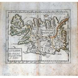
L'Islande par P. Du Val Geographe du Roy a Paris.
A nice, rare miniature map of Iceland from Pierre Duval's "La Geographie Universeille". Duval published a very small sized atlas containing a large number of ma...
Date: Paris, 1676
Selling price: ????
Please login to see price!
Sold in 2016

Insula Islandia.
Uncommon derivative of this miniature map of Iceland, earlier published in Pierre Duval's La Geographie Universeille.The copper plate is newly engraved, and the name of D...
Date: Nuremberg, 1678
Selling price: ????
Please login to see price!
Sold in 2016
Novissima Islandiae Tabula.
A beautiful map of Iceland, embellished with cartouches, compass roses, rhumb lines, and many other decorative features - all done in the style of Blaeu and Jansson by Mo...
Date: Oxford, 1680
Selling price: ????
Please login to see price!
Sold in 2016
Novissima Islandiae Tabula. Sumptibus Janssonio - Waesbergiorum, Mosis Pitt et Stephani Swart.
A beautiful map of Iceland, embellished with cartouches, compass roses, rhumb lines, and many other decorative features. Moses Pitt and Steven Swart used the copper plate...
Date: Oxford, 1680
Selling price: ????
Please login to see price!
Sold in 2017
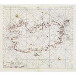
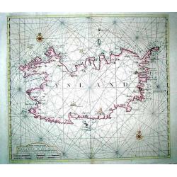
Wassende Graade Kaart van de Noord Oceaan – Van Terra Nova en de Straat Davids en Hudsons tot Hidland en de Westkust van Schotland en Engeland en Bretagne begrypende ook Yrland en Ysland.
Very decorative sea chart by J. Van Keulen, shows the North Atlantic, including Ireland, Iceland, and a portion of the coasts of Greenland, the Faroe Islands, a portion ...
Date: Amsterdam, 1694
Selling price: ????
Please login to see price!
Sold in 2026
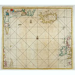
Landkenningen Aen De Zuyd West Syde Van Ysland
A rare cartographic work showing the coastlines of Iceland as they would appear from a ship at sea. The map title and descriptions of the coat are all done in Islandic la...
Date: Amsterdam, 1728
Selling price: ????
Please login to see price!
Sold in 2023
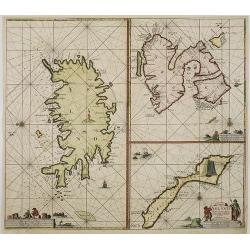
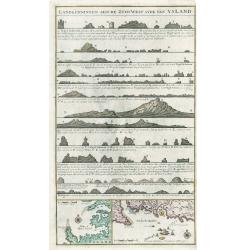
Paskaart van Ysland Spitsberge en Jan Mayen Eyland. . .
Three charts on one sheet. In the left hand part of the page a chart of Iceland. To the upper right "Spitsbergen" and lower right "Jan Mayen Island".P...
Date: Amsterdam, ca.1750
Selling price: ????
Please login to see price!
Sold in 2016
![Zuverlässige Nachrichten von Island [with] Landkarte von Island.](/uploads/cache/39895-250x250.jpg)
Zuverlässige Nachrichten von Island [with] Landkarte von Island.
>First German edition entitled "Zuverlässige Nachrichten von Island...", translation of Danish book from the previous year. Published in Copenhagen and Leipz...
Date: Copenhagen and Leipzig, 1753
Selling price: ????
Please login to see price!
Sold in 2017
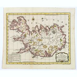
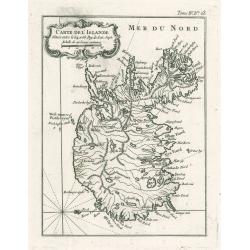
Karte von Island. . . N°1.
Map of Iceland. In: Allgemeine Historie der Reisen zur Wasser und zu Lande: oder Sammlung aller Reisebeschreibungen.. in Englischen zusammen getragen, und aus demselben u...
Date: Leipzig, 1753
Selling price: ????
Please login to see price!
Sold in 2015
Karte von Island. . . N°1.
Map of Iceland. In: Allgemeine Historie der Reisen zur Wasser und zu Lande: oder Sammlung aller Reisebeschreibungen.. in Englischen zusammen getragen, und aus demselben u...
Date: Leipzig, 1753
Selling price: ????
Please login to see price!
Sold in 2008
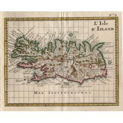
L Isle D\'Island
Small map of Iceland from Discours sur L'Histoire Universelle…
Date: Amsterdam 1755
Selling price: ????
Please login to see price!
Sold in 2014
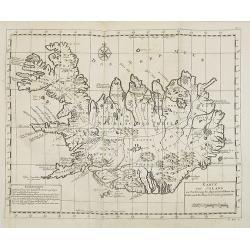
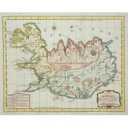
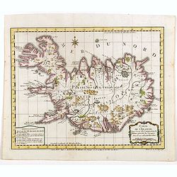
Carte de l'Islande pour servir á la continuation de l'histoire générale des voyages. Dressée sur celle de M. Horrebows.
A good engraved map of the island of Iceland, prepared by Bellin after M. Horrebows, with rococo title cartouche in lower right, explanation table bottom left. From L'His...
Date: Paris, 1758
Selling price: ????
Please login to see price!
Sold in 2021
Carte de l'Islande pour servir á la continuation de l'histoire générale des voyages. Dressée sur celle de M. Horrebows.
A good engraved map of the island of Iceland, prepared by Bellin after M. Horrebows, with rococo title cartouche in lower right, explanation table bottom left. From l'His...
Date: Paris, 1758
Selling price: ????
Please login to see price!
Sold in 2017
Carte de L'Islande . . .
A good engraved map of the island Iceland with rococo title cartouche lower right. From l'Histoire générale des voyages.
Date: Paris, 1758
Selling price: ????
Please login to see price!
Sold in 2011
Carte de l'Islande pour servir á la continuation de l'histoire générale des voyages. Dressée sur celle de M. Horrebows.
A good engraved map of the island of Iceland, prepared by Bellin after M. Horrebows, with rococo title cartouche in lower right, explanation table bottom left. From l'His...
Date: Paris, 1758
Selling price: ????
Please login to see price!
Sold in 2019
Carte De L'Islande
This elegant of Iceland by Bellin was published as part of his ‘Le Petit Atlas Maritime…’, which covered the world to the extent it was known and is one of the finest mar...
Date: Paris, 1764
Selling price: ????
Please login to see price!
Sold in 2023
Nyt Carte over Island..
Very rare map of Iceland, important map as it is the first map to show Rekjavik. Engraved by Jonas Haas, signed and dated 1772. Prepared by n, Professor John Erichsen (17...
Date: Aar 1771 - 1772
Selling price: ????
Please login to see price!
Sold
L'Isola d'Icelanda Divisa Ne Suoi Distretti Di nuova Projezione.
A very attractive map of Iceland, with a decorative title cartouche to the bottom right hand corner depicting a walled village amongst trees. Published in Zatta's "A...
Date: Venice, 1781
Selling price: ????
Please login to see price!
Sold in 2017
L'Isola d'Icelanda Divisa Ne Suoi Distretti Di nuova Projezione
A very attractive map of Iceland, with a decorative title cartouche to the bottom right hand corner depicting a walled village amongst trees.
Date: Venice, 1781
Selling price: ????
Please login to see price!
Sold
Nieuwe en seer Accurate Paskaart van het Eyland Yslandt In het Groot..
Printed in 1782, a scarce original chart of Iceland published by the renowned Amsterdam map and chart publishing dynasty founded by Johannes van Keulen. This chart replac...
Date: Amesterdam (1750) 1782
Selling price: ????
Please login to see price!
Sold in 2009
Nieuwe en seer Accurate Paskaart van het Eyland Yslandt In het Groot
Printed in 1782, a scarce original chart of Iceland published by the renowned Amsterdam map and chart publishing dynasty founded by Johannes van Keulen. This chart replac...
Date: Amesterdam (1750) 1782
Selling price: ????
Please login to see price!
Sold
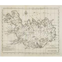
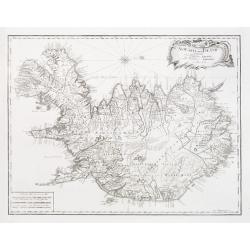
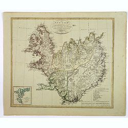
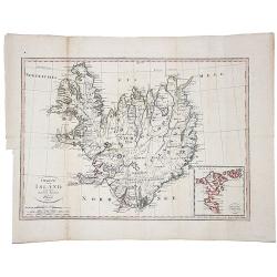
Die Insel Island Nro. 76.
An attractive map of Iceland based on the unpublished Knoff survey. The map locates villages and churches and graphically delineates the mountains, rivers, lakes and fore...
Date: Vienna, 1789
Selling price: ????
Please login to see price!
Sold in 2016
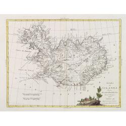
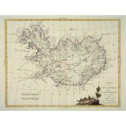
L'Isola d'Islanda Delineata Sulle ultime osservazioni.
Cassini’s splendid map depicts Iceland at the end of the eighteenth century. Though Iceland was geographically isolated from the European continent, for centuries it was ...
Date: Rome, 1796
Selling price: ????
Please login to see price!
Sold in 2018
L'Isola d'Islanda Delineata Sulle ultime osservazioni.
Cassini’s splendid map depicts Iceland at the end of the eighteenth century. Though Iceland was geographically isolated from the European continent, for centuries it was ...
Date: Rome, 1796
Selling price: ????
Please login to see price!
Sold in 2019
Island nach Murdochischer Projection...
An unusual map of Iceland by the German cartographer and geographer J.C.M. Reinecke, based on an earlier survey map by the Frenchman Verdun de la Crenne, done a generatio...
Date: Weimar, 1800
Selling price: ????
Please login to see price!
Sold in 2016
Island nach Murdochisher Projection. . .
An unusual, odd looking map of Iceland, based on Patrick Murdoch's projection of the previous century. As a result the island of Iceland looks 'shortened' or 'compacted'....
Date: Weimar, 1804
Selling price: ????
Please login to see price!
Sold in 2018
Charte von Island und den Faroer-Inseln.
An edition of this scarce map of Iceland, by an anonymous publisher in Prague.It shows excellent detail in the interior of the Island, including political subdivisions, t...
Date: Prague, 1808
Selling price: ????
Please login to see price!
Sold in 2021
Islande.
PLANO SHEET : Map of Iceland: No. 1.bis covering Iceland, from his famous Atlas Universel.This atlas was one of the most remarkable world atlases ever produced, anticipat...
Date: Brussels, 1825-1827
Selling price: ????
Please login to see price!
Sold in 2016

Les Islandais.
Showing the traditional hairstyle of the women of Iceland. From Giulio Ferrario's work Le Costume ancien et moderne ou histoire du gouvernement, de la milice, de la relig...
Date: Milan, 1827
Selling price: ????
Please login to see price!
Sold in 2018
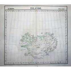
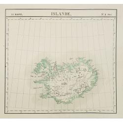
Islande N° 1
Highly detailed and important map Iceland. Shows the entire island with many towns, glaciers, rivers, bays,...Vandermaelen accomplished the first atlas with map of the wo...
Date: Brussels, 1827
Selling price: ????
Please login to see price!
Sold in 2011
L'Isola d'Islanda Delineata Sulle ultime osservazioni.
Cassini’s splendid map depicts Iceland at the end of the eighteenth century. Though Iceland was geographically isolated from the European continent, for centuries it was ...
Date: Rome, 1796- before 1839
Selling price: ????
Please login to see price!
Sold in 2018
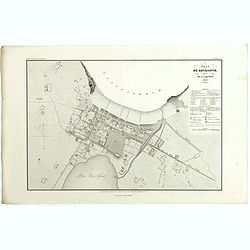
Plan de Reykjavík.
Detailed plan of Reykjavík from 'Voyage en Islande et au Groenland' by M. Paul Gaimard, published in Paris 1842. Engraved by Ambroise Tardieu' after 'V. Lottin'. Paul Gai...
Date: Paris, 1842
Selling price: ????
Please login to see price!
Sold in 2019
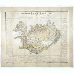
Uppdráttr Íslands / Carte d'Islande.
This rare and highly engaging map represents the first integrated (single-sheet) edition of Iceland's first accurate topographical map. Long considered among the most “c...
Date: Copenhagen, 1849
Selling price: ????
Please login to see price!
Sold in 2016
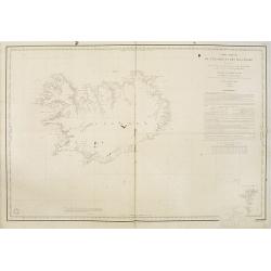
Carte réduite de l'Islande et des Iles Feroë. . . N°837.
Sea of Iceland and the Faroes Islands.Lighthouses are colored by hand in red and yellow. It shows soundings, anchorage's, channels, shoals, navigational sightings.
Date: Paris, 1872
Selling price: ????
Please login to see price!
Sold in 2015
