Browse Listings in Europe > Scandinavia > Sweden
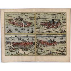
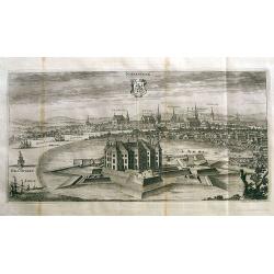
Helsheborch - Lunden - Elbogen - Landeskron.
Decorative bird's eye views of the cities Helsingburg, Lunden, Elbogen and Landeskron. Four city views on one sheet. More about Braun and Hogenberg, Civitatus [+]
Date: Cologne, 1593
Selling price: ????
Please login to see price!
Sold in 2016
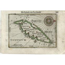
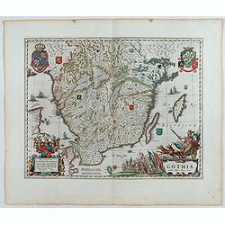
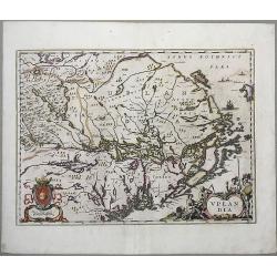
Gotland
Very fine early miniature map of Gotland, this map is from the first edition of the Langenes atlas, (later well known under the name of Bertius). Dutch text on verso.
Date: Middelburg, 1598
Selling price: ????
Please login to see price!
Sold in 2010
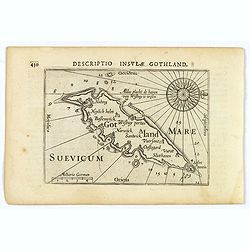
Descriptio Insulae Gothland.
A nice early miniature map by Petrus Bertius of the south eastern Swedish island of Gotland. Titled in bold above the map, with a large, ornate compass rose and rhumb lin...
Date: Amsterdam, 1606
Selling price: ????
Please login to see price!
Sold in 2021
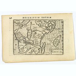
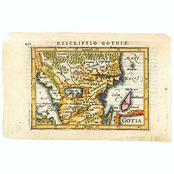
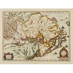
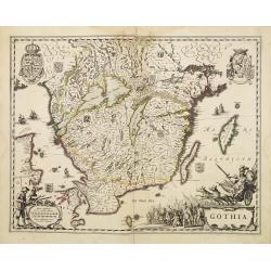
Gotia.
A miniature map showing a part of Sweden, including Stockholm. Title cartouche on the lower right corner. First published in 1598 in his "Caert-Thresoor", the p...
Date: Amsterdam, 1606
Selling price: ????
Please login to see price!
Sold in 2019
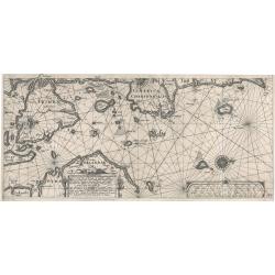
Pascaarte vande Belt, verthoonende de Oostersche Zeecuste van Iutlandt…
This is a very rare sea chart of the east coast of Denmark with the island of Fyn. The map is oriented with west at the top with two lovely compass roses indicating north...
Date: Amsterdam, 1608
Selling price: ????
Please login to see price!
Sold in 2023
Gotia.
A charming miniature map of part of Sweden that includes Gotland. Filled with forests, lakes, small islands and place names, and decorated with title and scale cartouches...
Date: Amsterdam, 1616
Selling price: ????
Please login to see price!
Sold in 2020
Gustavus Adolphus D.G. Sveciae. Gotth. et Vandal. Rex. / Russia.
The engraving depicts a half length oval portrait of "Gustavus Adolphus". Map of Russia on verso.Nicolaes de Clerck (de Klerc) was active as engraver and publis...
Date: Amsterdam, Cloppenburch, 1621
Selling price: ????
Please login to see price!
Sold
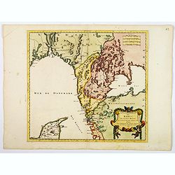
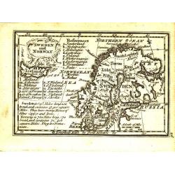
Suecia et Norvegia etc.
Small map of Scandinavia, surrounded by text in Dutch. On verso a copperplate engraving on text leaf depicting a half-length oval portrait of "Gustavus D G Sveciae G...
Date: Amsterdam, Cloppenburch, 1621
Selling price: ????
Please login to see price!
Sold in 2023
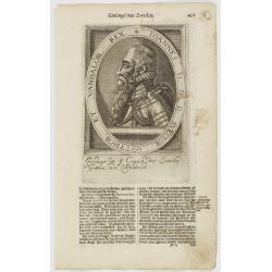
Ericus XIV. D G Sveciae, Gotthor. Vandalor. etc. Rex.
The engraving depicts a half length oval portrait of "Ericus XIV".Nicolaes de Clerck (de Klerc) was active as engraver and publisher in Delft from 1599-1621.Inc...
Date: Amsterdam, Cloppenburch, 1621
Selling price: ????
Please login to see price!
Sold
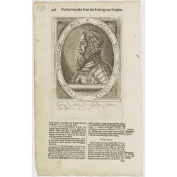
Ioannes II. D.G. Svecior. Gotthor. et Vandalor. Rex.
The engraving depicts a half length oval portrait of "Ioannes II".Nicolaes de Clerck (de Klerc) was active as engraver and publisher in Delft from 1599-1621.Inc...
Date: Amsterdam, Cloppenburch, 1621
Selling price: ????
Please login to see price!
Sold
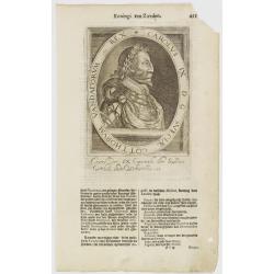
Carolus IX D G Sveciae Gotthorum Vandalorum etc. Rex.
The engraving depicts a half length oval portrait of "Carolus IX".Nicolaes de Clerck (de Klerc) was active as engraver and publisher in Delft from 1599-1621.Inc...
Date: Amsterdam, Cloppenburch, 1621
Selling price: ????
Please login to see price!
Sold
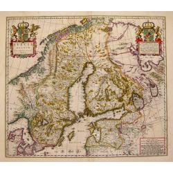
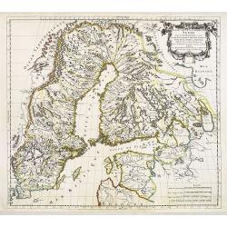
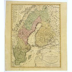
Tabula Exactissima Regnorum Suecia et Norvegiae. . .
A scarce detailed map of Scandinavia and the Baltic region, engraved by Abraham Goos of the Visscher family, after Ander Bure's six sheet map of Sweden published in 1626....
Date: Amsterdam, ca. 1630
Selling price: ????
Please login to see price!
Sold in 2018

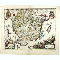
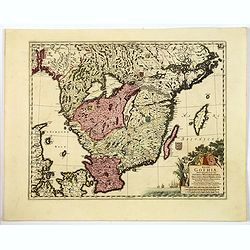
Gothia.
Southern part of Sweden including Stockholm, Uppsala, Gothenburg, Malmö. But also Copenhagen and Oslo.
Date: Amsterdam, 1638
Selling price: ????
Please login to see price!
Sold in 2008
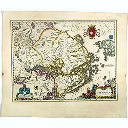
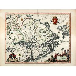
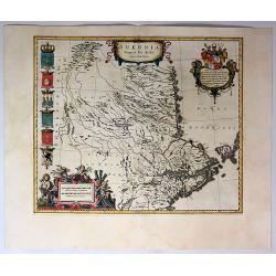
Uplandia.
Covers the area of the modern Uppsala, the vicinity of Stockholm, and includes most of Aland.
Date: Amsterdam, 1639
Selling price: ????
Please login to see price!
Sold in 2012
Gothia.
An attractive map of southern part of Sweden including Stockholm, Uppsala, Gothenburg, Malmö. But also Copenhagen and Oslo. A decorative title cartouche and a number of s...
Date: Amsterdam, ca 1640
Selling price: ????
Please login to see price!
Sold in 2020
Gothia.
Southern part of Sweden including Stockholm, Uppsala, Gothenburg, Malmö. But also Copenhagen and Oslo.
Date: Amsterdam 1639-1644
Selling price: ????
Please login to see price!
Sold
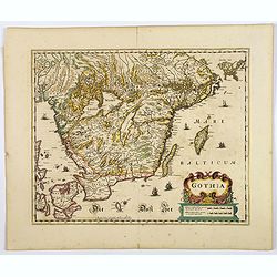
Gothia.
Very decorative map of the southern part of Sweden. The forested topography and lakes are well depicted.The main feature of the engraving is the large title cartouche sur...
Date: Amsterdam, 1644
Selling price: ????
Please login to see price!
Sold in 2017
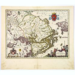
Ducatus Uplandia.
Nice map of Central Sweden around Stockholm with a decorative cartouche. More about Willem Blaeu. [+]
Date: Amsterdam, 1644
Selling price: ????
Please login to see price!
Sold in 2018
Ducatus Uplandia.
A beautifully engraved and executed map of the area of the modern Uppsala land in the vicinity of Stockholm, and includes most of Aland by Blaeu. With a Swedish coat of a...
Date: Amsterdam, ca. 1644
Selling price: ????
Please login to see price!
Sold in 2018
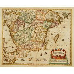
Gothia.
Very decorative map of the southern part of Sweden. The forested topography and lakes are well depicted.The main feature of the engraving is the large title cartouche sur...
Date: Amsterdam, 1645
Selling price: ????
Please login to see price!
Sold in 2023
Ducatus Uplandia. Joh. et Cornelius Blaeu exc
Original old colored map of central Sweden showing the area around Stockholm. With a Swedish coat of arms, a figural cartouche with rural people and a knight in amour, a ...
Date: Amsterdam, 1645
Selling price: ????
Please login to see price!
Sold in 2009
Uplandia.
A nice map of Uplandia, in central Sweden with its capital Stockholm. From 'Theatrum Orbis Terrarum, sive Atlas Novus in quo Tabulæ et Descriptiones Omnium Regionu' by wi...
Date: Amsterdam, 1645
Selling price: ????
Please login to see price!
Sold in 2021
Gothia.
Very decorative map of the southern part of Sweden. The forested topography and lakes are well depicted.The main feature of the engraving is the large title cartouche sur...
Date: Amsterdam 1645
Selling price: ????
Please login to see price!
Sold
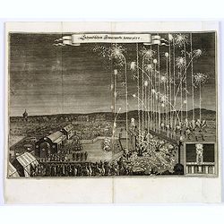
Schwedischen Feiverwerks, Anno 1650,
A night time fireworks display watched by an enthusiastic crowd, a print by M.Merian, published in his "Theatrum Europaeum." Banner title in German.
Date: Frankfurt am Main, 1650
Selling price: ????
Please login to see price!
Sold in 2019
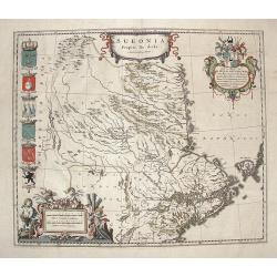
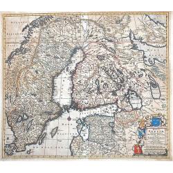
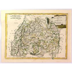
Sueonia Proprie Sie Dicta.
A very decorative map of eastern Sweden. Several beautiful cartouches are displayed. The left side is adorned with six municipal code of arms. There are a total of six pu...
Date: Amsterdam, 1660
Selling price: ????
Please login to see price!
Sold in 2019
Sueonia Proprie fie dicta.
A very decorative map of eastern Sweden. Several beautiful cartouche are displayed. The left side is adorned with municipal code of arms.
Date: Amsterdam, 1660
Selling price: ????
Please login to see price!
Sold in 2009
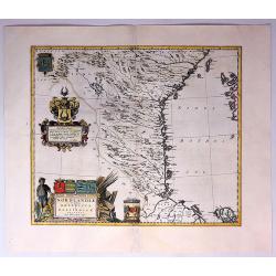
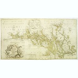
Norlandiae et Quibies Gestricia et Helsingicae Regiones.
A striking, rare map with a cartouche dedicated to Gabriel Bengtsson Oxenstierna. The 'Atlas Maior' is the epitome of decades of achievement by the famous Blaeu family. P...
Date: Amsterdam, 1662
Selling price: ????
Please login to see price!
Sold in 2017
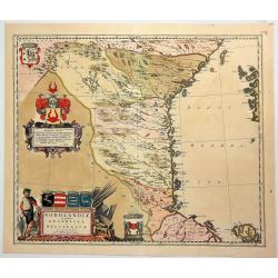
Nordlandiae et Quibies Gestricia et Helsingicae Regiones.
A fine antique map of Sweden or Norrland, with two originally colored cartouches, a figured title cartouche and a heraldic cartouche, with a total of six coats-of-arms in...
Date: Amsterdam, 1662
Selling price: ????
Please login to see price!
Sold in 2018
Sveciae Regnum.
An attractive map of the Kingdom of Sweden from the famous Blaeu company.
Date: Amsterdam, 1664
Selling price: ????
Please login to see price!
Sold
Gouvernement de Bahus tire de divers Memories.
An attractive map covering modern day Sweden and Norway, with just the northern tip of Jutland also. When this map was published Bahus belonged to Norway, however, it now...
Date: Paris, 1668
Selling price: ????
Please login to see price!
Sold in 2018
Estats de la Couronne de Suede dans la Scandinavie, ou Sont Suede, Gotlande, Lapponie Suedoise, Finlande, Ingrie et Livonie Subdivisées en leurs Provinces . . .
Attractive map of Sweden, Finland and the Baltic States
Date: Paris, Marriette, 1669
Selling price: ????
Please login to see price!
Sold
Regni Sueciae Tabula Generalis, divisa in Sueciae, Gotiae, Regna Finlandiae Ducatum Lapponiam...
Nice example of De Wit map of Scandinavia.
Date: Amsterdam, 1680
Selling price: ????
Please login to see price!
Sold in 2013
![[Lot of 3 maps] Uplandia, plus a map of the island of Ruegen by W, Blaeu and the General map of Scandinavia by Reinier & Joshua Ottens.](/uploads/cache/82017-250x250.jpg)
[Lot of 3 maps] Uplandia, plus a map of the island of Ruegen by W, Blaeu and the General map of Scandinavia by Reinier & Joshua Ottens.
An attractive map of Upland with Stockholm. With two nice cartouches. Moses Pitt (d.London,1696), planned to publish together with Janssonius' son-in-law, Janssonius van ...
Date: London, 1680
Selling price: ????
Please login to see price!
Sold in 2022
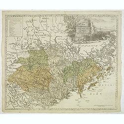
Regni Gothiae Tabula Generalis, in qua sont. . .
A striking map of southern Sweden, the islands of Gotland and Oland, a portion of northern Denmark, and Norway as far as Oslo by the Dutch cartographer and artist, Freder...
Date: Amsterdam, ca 1680
Selling price: ????
Please login to see price!
Sold in 2019
Accurata Scaniae Blekingae, et Hallandiae . . .
With an inset showing the coast from Gothenburg till Warberg.
Date: Amsterdam, 1690
Selling price: ????
Please login to see price!
Sold in 2011
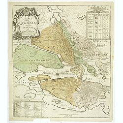
Gothebourg ...
Charming bird's-eye plan of the fortification of the city of Gothenburg on the west coast of Sweden.Nicolas de Fer held the title of Geographer at Louis XIV's court. He w...
Date: Paris, 1695
Selling price: ????
Please login to see price!
Sold in 2011
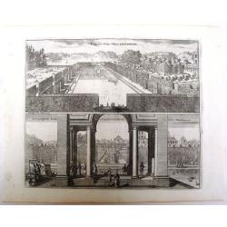
Prospectus Euripi e Palatio Rosersberg.
Two striking copper engravings featuring the Rosersberg Palace. Engraved by Swiddle in 1696.Count Erik Dahlberg (1625-1703) was a Swedish soldier, engineer and graphic a...
Date: Stockholm, 1696
Selling price: ????
Please login to see price!
Sold in 2017

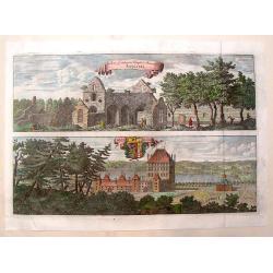
Saswestaholm & Sioosa.
A lovely copper engraving of two prominent buildings in Sweden by Dahlberg. There are two decorative coasts of arms held by putti. Count Erik Dahlberg (1625-1703) was a S...
Date: Stockholm, 1697
Selling price: ????
Please login to see price!
Sold in 2017
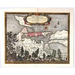
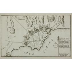
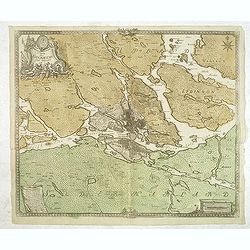
Ichnographia Oppidi et Munimenti Christianopolis ...
Kristianopel, at the eastern end of the province of Blekinge, was founded in 1603 by King Christian IV of Denmark as a defense against Swedish attacks. The province of Bl...
Date: Nuremberg, 1697
Selling price: ????
Please login to see price!
Sold in 2019
Norrkiöping.
Rare view of Norrköping in Sweden, with its "Star Fort" before it was destroyed during the Russian attack in 1719. Published by Erik Dahlberg. Highly detaile...
Date: Stockholm, 1706
Selling price: ????
Please login to see price!
Sold in 2012
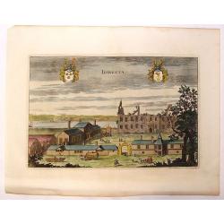
Idingsta.
Fine hand-colored, copper engraving of Idingsta, Sweden.Jan van den Aveele or Aveelen (1650 - 1727) was a Dutch etcher and engraver. With compatriot Willem Swidde, he mad...
Date: Stockholm, 1709
Selling price: ????
Please login to see price!
Sold in 2013
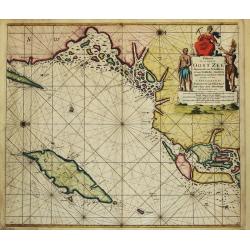
Paskaart Voor een gedeelte van de Oost-Zee. Beginnende van Valsterborn tot Schenkkenes.
A sea chart of the southwest part of the Baltic with two insets showing the coast between Kristianstad and Calmer, and the ports of 'Selfborgh, Boetekolen Rottenbuy'....
Date: Amsterdam, 1715
Selling price: ????
Please login to see price!
Sold in 2021
Pascaart Om door de Sond En de Droogen te Seylen Stekkende van Kol tot Meun.
The successful van Keulen firm published charts, pilot guides and sea-atlases for over 2 centuries. Founded by Johannes van Keulen, his son Gerard led the firm to its zen...
Date: Amsterdam, 1715
Selling price: ????
Please login to see price!
Sold
Paskaart Voor een gedeelte van de Oost-Zee. Beginnende van Schenkkenes tot aan Stokholm.
The successful van Keulen firm published charts, pilot guides and sea-atlases for over 2 centuries. Founded by Johannes van Keulen, his son Gerard led the firm to its zen...
Date: Amsterdam, 1715
Selling price: ????
Please login to see price!
Sold
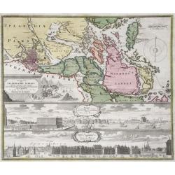
Accurate Carte der Uplandischen Scheren mid der Situation und Gegend umb die Konigl. Schwedische Haupt und Residentz Stadt Stockholm.
Johann Christoph Homann - Accurate Carte der Uplandischen Scheren - Nuremberg, ca. 1730. Sweden - Stockholm: Accurate map of the Upland skerries with the situation and ar...
Date: Nürnberg, ca 1720
Selling price: ????
Please login to see price!
Sold in 2021
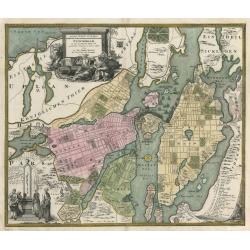
Accurater Grundriß und Prospect Der Kön. Schwed. Reichs. u. Hauptstadt Stockholm
This superb early eighteenth century map of Stockholm in full original hand colour is from Homann’s Maior Atlas Superiore. The map depicts Stockholm as it was at the tim...
Date: Nuremburg, 1720
Selling price: ????
Please login to see price!
Sold in 2023
Rudera Sive Reliquia Templi et Monesteri Alfvastrae / Braaborg.
View of the ruins of the 12th century Cistercian monastery at Alvastra. Also, view of the palace at Braaborg. From Dahlbergh's "Suecia Aniqua et Hodierna". Feat...
Date: Stockholm, 1723
Selling price: ????
Please login to see price!
Sold in 2013
Charta öfwer Mälaren, med Kongl: Maj.ts. nådigste privilegio utgifven af Kong:e Landtmäteri Contoiret.
A scarce map of the district of Mälaren Sweden. A large title cartouche upper left and a key in the lower left corner. The map is a part of a work by Kongl. Landtmäteri C...
Date: Stockholm, 1742
Selling price: ????
Please login to see price!
Sold in 2015
Charta öfwer Södermanland Med Kongl. Maj.ts. Nådigste privilegio utgifven af Kong:e Landtmäteri Contoiret.
A scarce map of the district of Södermanland, including Stockholm in Sweden. A large title cartouche upper right and a key in the upper left corner. The map is a part of ...
Date: Stockholm, c.1747
Selling price: ????
Please login to see price!
Sold in 2012
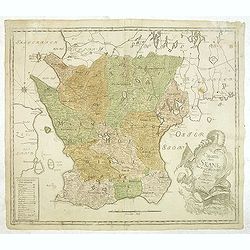
Charta öfwer Skåne. Med Kongl. Maj.ts. nådigste privilegio utgifven af Kongl. Landtmäteri Contoiret.
A scarce map of the district of Skåne in Sweden. A large title cartouche lower right and a key in the lower left corner. The map is a part of a work by Kongl. Landtmäteri...
Date: Stockholm, c.1750
Selling price: ????
Please login to see price!
Sold in 2013
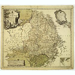
Charta öfwer Upland och Söder Törn. Med Kong. Maj.ts. Nådigste privilegio utgifven af Kongl. Landtmäteri Contoir.
A scarce map of the district of Upland in Sweden. A large title cartouche upper left and a key in the upper right corner. The map is a part of a work by Kongl. Landtmäter...
Date: Stockholm, c.1750
Selling price: ????
Please login to see price!
Sold in 2012
Charta öfwer Stockholm med des malmar och förstäder af Hans Konge Majt. til strandernes anlaggning i nader faststäld den 1. julii 1751.
A scarce town-plan of Stockholm. The map was engraved by Georg Biurmans himself and covers a large area around Stockholm. The major roads are carefully recorded. A large ...
Date: Stockholm, c.1751
Selling price: ????
Please login to see price!
Sold in 2012
Charta öfwer Stockholms Stads Belägenhet.
A scarce town-plan of Stockholm. The map was engraved by Georg Biurmans himself and covers a large area around Stockholm including Drottningholm Palace in the west and in...
Date: Stockholm, c.1751
Selling price: ????
Please login to see price!
Sold in 2012

J.Anckerstöm a killer of King Gustave III.
Decorative aquatint engraving after Witterquits.
Date: Augsburg 1780
Selling price: ????
Please login to see price!
Sold

J.Anckerstöm a killer of King Gustave III.
Uncommon and decorative aquatint full length portrait of J.Anckerstöm. This aquatint by T.C. Lotter was made after a design of Witterquits.Gustav III (1746 – 1792) was Ki...
Date: Augsburg, 1780
Selling price: ????
Please login to see price!
Sold in 2014
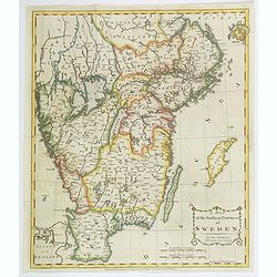
A Map of the Southern Provinces of Sweden.
An attractive map of the southern most provinces of Sweden, published by T. Cadell for Thomas Kitchin, 'Hydrographer to his Majesty' (King George III). Map extends from b...
Date: London, ca 1784
Selling price: ????
Please login to see price!
Sold in 2020
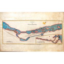
Canal of Trolhaetta.
Copper engraved map by Thomas Kitchen, published by T. Cadell in 1784. The map is of the Trihaetta Canal that is between Gothenburg and Stockholm Sweden.
Date: London, 1784
Selling price: ????
Please login to see price!
Sold in 2016
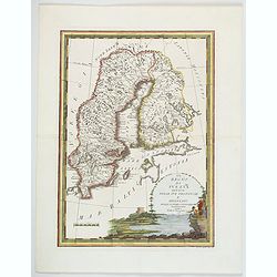
Sweden and Norway.
Uncommon miniature map from Gibson's "Atlas Minimus, or a New Set of Pocket Maps of the several Empires, Kingdoms and States of the known World".
Date: London, 1792
Selling price: ????
Please login to see price!
Sold
Charte uber das Konigreich Schweden. . .
A detailed map of the Kingdom of Sweden, which until 1809 included Finland, which was then lost to Russia. The original tri-colors of the map are typical of the period. S...
Date: Nuremberg, 1793
Selling price: ????
Please login to see price!
Sold in 2018
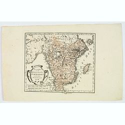
Il Circulo di Svevia.
"The Circle of Swabia" and below "1793 at Siena Pazzini Carli". The map comes from "Atlante Geografico...", the rare geographical atlas that...
Date: Siena, 1793
Selling price: ????
Please login to see price!
Sold in 2018
Il Regno di Svezia divisio nelle sue provincie e delineato. . .
This delightful map of Sweden and Finland highlights rivers, lakes, mountains and towns. The decorative title cartouche depicts a man fishing with small ships sailing in ...
Date: Rome, 1796
Selling price: ????
Please login to see price!
Sold in 2020
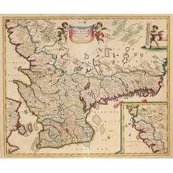
Spezial Karte vom des Konigreichs Schweden sudlichen Provinzen. . .
Map shows the southern most part of Sweden, Götaland. The area includes the ten historical provinces, also called "Landscapes", Småland, Öland, Västergötland, Ö...
Date: Vienna, 1796
Selling price: ????
Please login to see price!
Sold in 2020
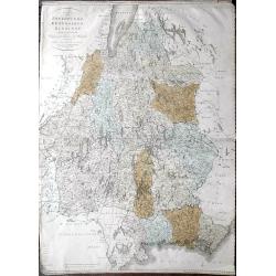
Karta öfver Jönköpings Kronobergs och Blekings Höfdingdöme utgifven af Friherre S. G. Hermelin.
A highly detailed large-scale map of Småland and Blekinge in southern Sweden. The map shows the area from Gränna and Jönköping with the Vättern lake, until Kristianstad a...
Date: Stockholm, 1810
Selling price: ????
Please login to see price!
Sold in 2019
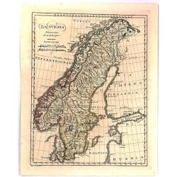
La Svezia Norissima.
A fine detailed map of Sweden
Date: Florence, 1818
Selling price: ????
Please login to see price!
Sold in 2016
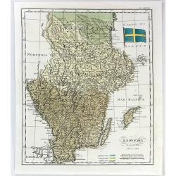
La Svezia e la Gotia.
A fine map of Sweden by Francesco Constantino Marmocchi. It is from the atlas "Atlante di Geogrfia Universale" published in Florence in 1838. The map features a...
Date: Florence, 1838
Selling price: ????
Please login to see price!
Sold in 2016
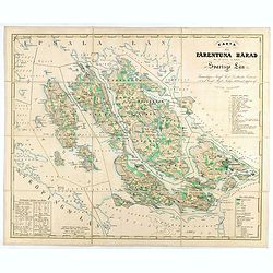
Karta öfver Färentuna härad eller det fordom så kallade Svartsjö län,
Fine and detailed map prepared by Victor Dahlgren (1815-1870).
Date: Stockholm, 1853
Selling price: ????
Please login to see price!
Sold in 2025
