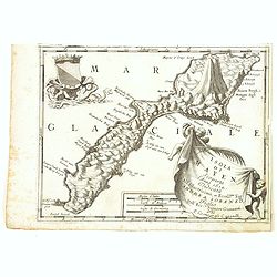
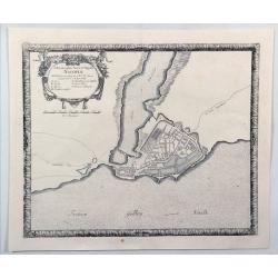
Browse Listings in Europe > Scandinavia
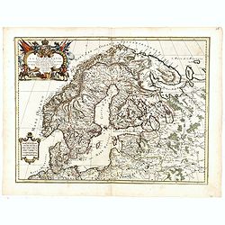
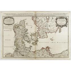
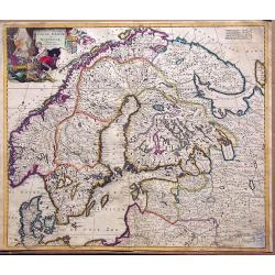
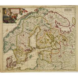
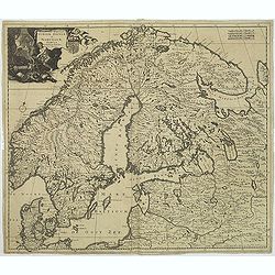
La Scandinavia...
Giacomo Rossi's fine late 17th century map of Scandinavia. Issued in Il Mercurio geografico In upper left corner an ornate tittle cartouche. The cartographer was Giacomo ...
Date: Rome, 1678
Selling price: ????
Please login to see price!
Sold in 2017
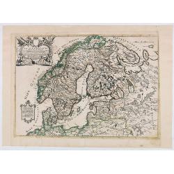
La Scandinavia...
Giacomo Rossi's fine late 17th century map of Scandinavia. Issued in Il Mercurio geografico In upper left corner an ornate tittle cartouche. The cartographer was Giacomo ...
Date: Rome, 1678
Selling price: ????
Please login to see price!
Sold in 2020

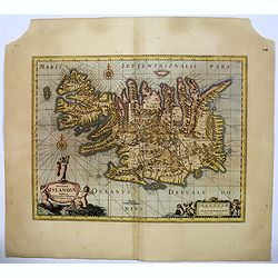
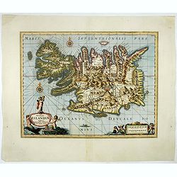
Insula Islandia.
Uncommon derivative of this miniature map of Iceland, earlier published in Pierre Duval's La Geographie Universeille.The copper plate is newly engraved, and the name of D...
Date: Nuremberg, 1678
Selling price: ????
Please login to see price!
Sold in 2016
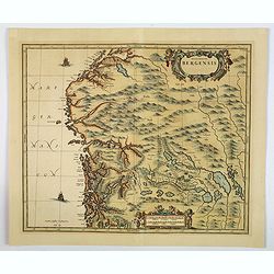
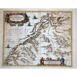
Episcopatus Bergensis.
An uncommon issue of Janssonius' map of the area around Bergen, in Norway, first issued in 1658. After Jansson's death in 1664 the plate came into the possession of his s...
Date: Oxford, ca 1680
Selling price: ????
Please login to see price!
Sold in 2019
![[Lot of 3 maps] Uplandia, plus a map of the island of Ruegen by W, Blaeu and the General map of Scandinavia by Reinier & Joshua Ottens.](/uploads/cache/82017-250x250.jpg)
[Lot of 3 maps] Uplandia, plus a map of the island of Ruegen by W, Blaeu and the General map of Scandinavia by Reinier & Joshua Ottens.
An attractive map of Upland with Stockholm. With two nice cartouches. Moses Pitt (d.London,1696), planned to publish together with Janssonius' son-in-law, Janssonius van ...
Date: London, 1680
Selling price: ????
Please login to see price!
Sold in 2022
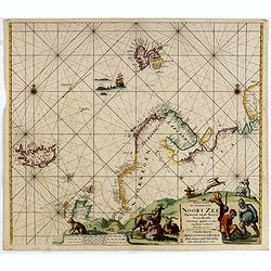
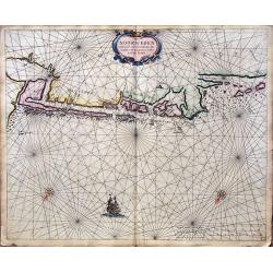
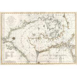
Paskaart Van 't Noordelykste deel der Noort Zee Beginnende van der Neus tot Nova Zembla. . . .
Very fine chart with Iceland to the left and reaching till Nova Zembla, including of Iceland, Spitzbergen, Northern Scotland, Russia and Scandinavia with just a hint of G...
Date: Amsterdam, 1680
Selling price: ????
Please login to see price!
Sold in 2016
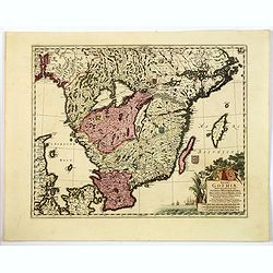
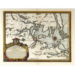
Regni Gothiae Tabula Generalis, in qua sont. . .
A striking map of southern Sweden, the islands of Gotland and Oland, a portion of northern Denmark, and Norway as far as Oslo by the Dutch cartographer and artist, Freder...
Date: Amsterdam, ca 1680
Selling price: ????
Please login to see price!
Sold in 2019
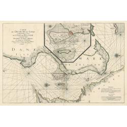
Caerte van Noorwegen vande hoeck van Horrel tot aen Momendael, waer in begrepen wert het Liet van Dronten.
A rare sea Chart shows part of the Norwegian coast, from Horrel to Trondheim. Nice original colors.
Date: Amsterdam, 1680
Selling price: ????
Please login to see price!
Sold in 2018
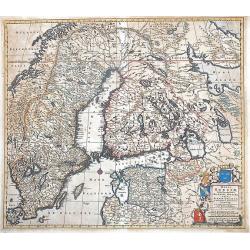
Regni Sueciae Tabula Generalis, divisa in Sueciae, Gotiae, Regna Finlandiae Ducatum Lapponiam...
Nice example of De Wit map of Scandinavia.
Date: Amsterdam, 1680
Selling price: ????
Please login to see price!
Sold in 2013
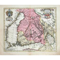
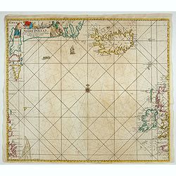
Novissima Islandiae Tabula.
A beautiful map of Iceland, embellished with cartouches, compass roses, rhumb lines, and many other decorative features - all done in the style of Blaeu and Jansson by Mo...
Date: Oxford, 1680
Selling price: ????
Please login to see price!
Sold in 2016
Novissima Islandiae Tabula. Sumptibus Janssonio - Waesbergiorum, Mosis Pitt et Stephani Swart.
A beautiful map of Iceland, embellished with cartouches, compass roses, rhumb lines, and many other decorative features. Moses Pitt and Steven Swart used the copper plate...
Date: Oxford, 1680
Selling price: ????
Please login to see price!
Sold in 2017
![[No title] Spitzbergen.](/uploads/cache/02427-250x250.jpg)
[No title] Spitzbergen.
Greenland split in two and Wiches Lande at the edge of the map, complete with compass-rose, galleon and monsters. Surrounded by eleven scenes of whaling from capture to b...
Date: London 1680
Selling price: ????
Please login to see price!
Sold in 2020

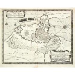
Nova Tabula Magni Ducatus Finlandiae.
The map is based on the archetypal map of the Swede Anders Bure. It is the first map to show the Grand-Duchy of Finland on its own. A remarkably beautiful cartouche displ...
Date: Amsterdam, 1680
Selling price: ????
Please login to see price!
Sold in 2009
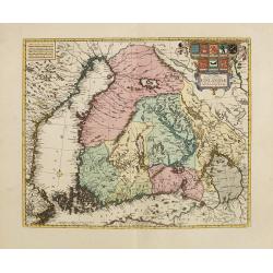
Nova Tabula Magni Ducatus Finlandiae. . .
The map is based on the archetypal map of the Swede Anders Bure. It is the first map to show the Grand-Duchy of Finland on its own. A remarkably beautiful cartouche displ...
Date: Amsterdam, 1680
Selling price: ????
Please login to see price!
Sold in 2010
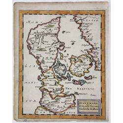
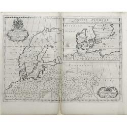
DANEMARK yizt IUTLAND, ZELAND, Sleswick, Holstein
A copperplate map of Denmark from Sir Jonas Moore's "New System of Mathematics" London, Printed by A. Godbid and J. Playford, for Robert Scott, 1681.
Date: London, 1681
Selling price: ????
Please login to see price!
Sold in 2017
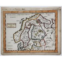
SWEDLAND and NORWAY
A copperplate map of Scandinavia / Baltic from Sir Jonas Moore's "New System of Mathematics" London, Printed by A. Godbid and J. Playford, for Robert Scott, 168...
Date: London, 1681
Selling price: ????
Please login to see price!
Sold in 2019
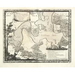
Dioecesis Trundhemiensis pars Australis.
From his "Atlas major, sive, Cosmographia universalis, adeoque orbis terrestris, maritimus, antiquus & coelestis : in quo tabulae cum descriptionibus omnium regi...
Date: Oxford, 1682
Selling price: ????
Please login to see price!
Sold in 2014
Magnus Ducatus Finlandiae nova et accurata delineatio.
Very decorative, large map depicting part of the Scandinavian countries, Russia, Finnland. With two decorative cartouches with dedication to J.Schütz. Partly colored usin...
Date: Oxford, 1682
Selling price: ????
Please login to see price!
Sold in 2012
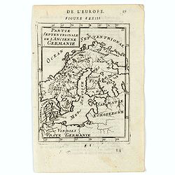
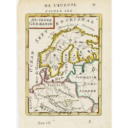
Partie Septentrionale de l'Ancienne Germanie.
A charming map of ancient Scandinavia. Title in curtain draped at top. French text on verso.From the original 1683 text edition of "Description d'Univers. . ." ...
Date: Paris, 1683
Selling price: ????
Please login to see price!
Sold in 2020
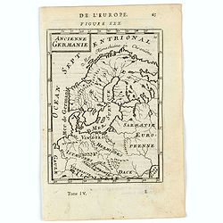
Ancienne Germanie.
A map of ancient Scandinavia and Germany. Title in curtain draped at top. French text on verso.From the original 1683 text edition of "Description d'Univers. . .&quo...
Date: Paris, 1683
Selling price: ????
Please login to see price!
Sold in 2020
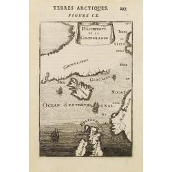
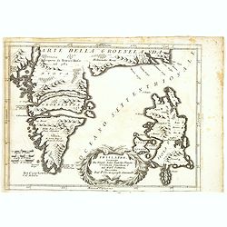
Groenlande.
An interesting miniature map of Greenland and northern Canada. Place names are only shown in Greenland.The sea is fully engraved and two ships are shown in battle just be...
Date: Paris, 1683
Selling price: ????
Please login to see price!
Sold in 2009
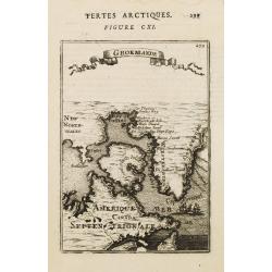
Decouverte de la Groenlande.
An interesting miniature map centered on Iceland and outlining most part of Greenland. Northwest on top. It includes Norway and great part of the British Isles.The sea is...
Date: Paris 1683
Selling price: ????
Please login to see price!
Sold
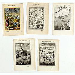
(Five engravings of Scandinavian interest from Description de l\'Univers)
Finely etched prints and maps, entitled : Islande, Isle d'Islande, Suede, Decowerte de la Groenlande, Norvvegiens. From the French text edition of Description d'Univers.....
Date: Paris, 1683
Selling price: ????
Please login to see price!
Sold in 2015
Ancienne Germanie.
Attractive map of Scandinavia from the French text edition of Description d'Univers, 1683. By Allain Manneson Mallet (1630-1706), a well traveled military engineer and ge...
Date: Paris, 1683
Selling price: ????
Please login to see price!
Sold in 2009
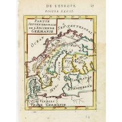
Partie Septentrionale de l'Ancienne Germanie.
Small map of Scandinavia from the French text edition of Description d'Univers, 1683. By Allain Manneson Mallet (1630-1706), a well traveled military engineer and geograp...
Date: Paris, 1683
Selling price: ????
Please login to see price!
Sold in 2009
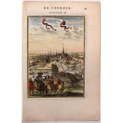
Copenhague, City View of Copenhagen, Denmark
Nice little city view map of Copenhagen by Mallet from 1683. Hand-colored copper engraving.
Date: Paris, 1683
Selling price: ????
Please login to see price!
Sold in 2016
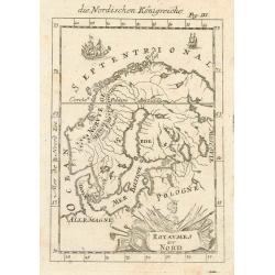
Royaumes du Nord.
Interesting map of Scandinavia.
Date: Paris, 1683
Selling price: ????
Please login to see price!
Sold in 2010
Le Royaume de Danmark subdivisé en ses Principales Provinces..
A decorative map of Denmark prepared by N.Sanson and published by Hubert Jaillot.
Date: Paris 1685
Selling price: ????
Please login to see price!
Sold
Le Royaume de Danmark..
A decorative map of Denmark prepared by N.Sanson and published by Hubert Jaillot.
Date: Paris, 1685
Selling price: ????
Please login to see price!
Sold in 2014
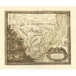
Sacrae Regiae Maj: Caroli Gustavi ..
Decorative panoramic views of Malmo and Landskrona in Sweden. Prepared by Count Erik Jönsson Dahlberg[h] (1625-1703). Military engineer and cartographer of Stockholm. He ...
Date: Stockholm, 1689
Selling price: ????
Please login to see price!
Sold in 2011
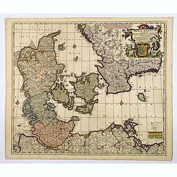
Dania Regnum In quo sunt Ducatus Holsatia et Slesvicum..
An attractive map centred on Denmark. Very ornamented title cartouche in the upper right-hand corner.
Date: Amsterdam, 1690
Selling price: ????
Please login to see price!
Sold
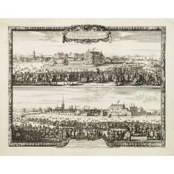
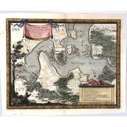
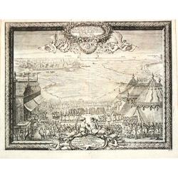
Anno HAFNIA Daniae met: COPPENHAGEN 1659.
During the Northern Wars, the Swedish army under Charles X Gustav of Sweden, after invading the Danish mainland of Jutland, swiftly crossed the frozen straits and occupie...
Date: Amsterdam, ca. 1690
Selling price: ????
Please login to see price!
Sold in 2017
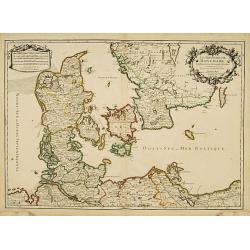
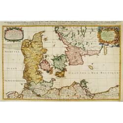
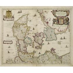
Accuratissima regnorum sueciae, daniae et norvegiae tabula.
Uncommon map of the Scandinavian peninsula with a large, very decorative title cartouche in upper left corner.Includes Sweden, Denmark, Norway and a part of Russia.
Date: Amsterdam, 1690
Selling price: ????
Please login to see price!
Sold in 2014
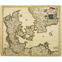
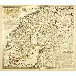
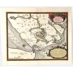
Regni Sueciae Tabula Generalis, divisia in Suediae, Gothiae. . .
An attractive and detailed map of Scandinavia, centered on Finland, including parts of Sweden, Norway and Russia. Nicely colored to accentuate the seas, mountains, lakes ...
Date: Amsterdam, 1690
Selling price: ????
Please login to see price!
Sold in 2019
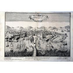
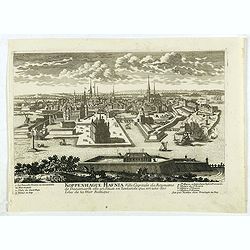
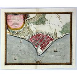
Coppenhague Ville Capitale du Royaume de Danemarck est située en Zeelande qui est une des Isles de la Mer BALTIQUE
Very rare, large decorative view of Copenhagen. The view shows an elaborate waterfront image, with wharves, windmills, shipbuilding, etc. 7 major sites are identified in ...
Date: Paris?, ca 1690
Selling price: ????
Please login to see price!
Sold in 2023
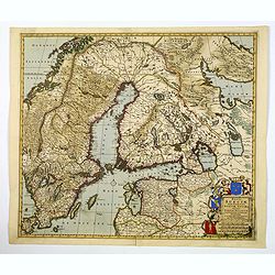
![[ Lot of 9 maps and plans] Novissima nec non Perfectissima Scandinaviae Tabula](/uploads/cache/18177-(3)-250x250.jpg)
[ Lot of 9 maps and plans] Novissima nec non Perfectissima Scandinaviae Tabula
Frederick de Wit's large and detailled map of Scandinavia. Embellished with a large, decorative title-cartouche.From Frederick de Wit's' Atlas Maior'. Frederik de Wit (16...
Date: Amsterdam, 1690
Selling price: ????
Please login to see price!
Sold in 2022
Accurata Scaniae Blekingae, et Hallandiae . . .
With an inset showing the coast from Gothenburg till Warberg.
Date: Amsterdam, 1690
Selling price: ????
Please login to see price!
Sold in 2011
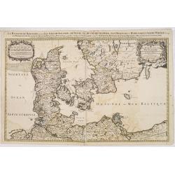
Dania Regnum In quo sunt Ducatus Holsatia et Slesvicum Iutia, et Insule, dictae Danicae. . .
An attractive map centered on Denmark and including southern tip of Sweden. Enhanced by a very ornamented title cartouche in the upper right-hand corner. colored mileage ...
Date: Amsterdam ca 1690
Selling price: ????
Please login to see price!
Sold in 2020
Les Royaumes De Suede, de Danemarck et De Norwege Divisez en plusieurs Provincez, et Gouvernemens, etc. selon les Memoires de Bxxx de Scheffer, et de plusieurs autres Corrigee et augmentez apr le Sr. de Tillemon . . .
Rare map of Scandinavia and the Baltic with inset map of Iceland. Published by Jean Baptiste Nolin, the Geographer to the King of France. With large text panels giving ge...
Date: Paris, 1691
Selling price: ????
Please login to see price!
Sold in 2014
Le royaume de Danemark.
Fine map of Denmark with a decorative title and scale cartouche.Alexis-Hubert Jaillot (1632-1712), was a French cartographer. He joined the Sanson heirs and redrew Nicola...
Date: Amsterdam, 1692
Selling price: ????
Please login to see price!
Sold in 2013
Le Royaume de Danmark.
Large scale map of Denmark. Prepared by Sanson and published by Jaillot.Very large and decorative piece.
Date: Paris 1692
Selling price: ????
Please login to see price!
Sold
![[Lot of 8 maps of Denmark and Scandinavia] Le Royaume de / Danemark / subdicise en ses principales provences.via](/uploads/cache/18385-(4)-250x250.jpg)
[Lot of 8 maps of Denmark and Scandinavia] Le Royaume de / Danemark / subdicise en ses principales provences.via
Alexis-Hubert Jaillot (1632-1712), French cartographer. He joined the Sanson heirs and redrew Nicolas Sanson's maps on a larger scale. 'Atlas Nouveau' (1674), sea-atlas '...
Date: 1692
Selling price: ????
Please login to see price!
Sold in 2022
Koppenhague Hafnia Ville Capitale du Royaume de Denmarck. . .
A very decorative and extremely raretown-viewof Copenhagen, including a numbered key ( 1- 7 ) in lower part. Engraved by Pierre-Alexandre Aveline. With "fait par Ave...
Date: Paris, ca.1692
Selling price: ????
Please login to see price!
Sold in 2019
Danemarq et Sud-Gothlande.
Lovely small map of Denmark.
Date: Antwerp, 1692
Selling price: ????
Please login to see price!
Sold in 2011
Le Royaume de Danemark subdivisé en ses Principales Provinces..
Handsome map of Denmark and part of Sweden.
Date: Paris, 1692
Selling price: ????
Please login to see price!
Sold in 2009
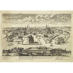
Koppenhague Hafnia Ville Capitale du Royaume de Denmarck. . .
A very decorative and extremely rare town-view of Copenhagen, including a numbered key ( 1- 7 ) in lower part. Engraved by Pierre-Alexandre Aveline. With "fait par A...
Date: Paris, ca.1692
Selling price: ????
Please login to see price!
Sold in 2011
Carte de la Mer de Dannemark et des Entrees dans la Mer Baltique
This magnificent, important sea chart is the work of French statesman Alexis-Hubert Jaillot. It is from the first edition of a French sea atlas entitled Neptune François,...
Date: 1693
Selling price: ????
Please login to see price!
Sold in 2023
Carte de Detroit du Sond Contenant les Costes de L'Isle de Zélande Comprises ente Nicopen et L'Isle de Meun, et Celles du Schonen Depuis la Pointe de Kol, jusqu'a Valsterbon.
This is a lovely nautical chart of the sound between Sweden and Denmark produced during the golden age of map making. This sea chart was part of Pierre Mortier's 'Le Nept...
Date: Amsterdam 1693
Selling price: ????
Please login to see price!
Sold in 2023
Wassende Graade Kaart van de Noord Oceaan – Van Terra Nova en de Straat Davids en Hudsons tot Hidland en de Westkust van Schotland en Engeland en Bretagne begrypende ook Yrland en Ysland.
Very decorative sea chart by J. Van Keulen, shows the North Atlantic, including Ireland, Iceland, and a portion of the coasts of Greenland, the Faroe Islands, a portion ...
Date: Amsterdam, 1694
Selling price: ????
Please login to see price!
Sold in 2026
Scandinavia or the Kingdoms of Denmark, Sueden, Norway & Lapland.
A nice late seventeenth century map of Scandinavia, as it was then. It depicts Sweden occupying modern day Finland, and shows part of Iceland, England and Ireland, all of...
Date: London, 1695
Selling price: ????
Please login to see price!
Sold in 2018
Gothebourg ...
Charming bird's-eye plan of the fortification of the city of Gothenburg on the west coast of Sweden.Nicolas de Fer held the title of Geographer at Louis XIV's court. He w...
Date: Paris, 1695
Selling price: ????
Please login to see price!
Sold in 2011
Frislanda, Scoperta da Nicolo Zeno Patritio Veneto Creduta Favolosa, o nel Mare Somersa . . .
A fine map of the mythical island of "Frislandia", based upon the writings of Nicolo Zeno.Frislanda, which was purportedly discovered by the Zeno brothers in a ...
Date: Venice, 1696
Selling price: ????
Please login to see price!
Sold in 2013
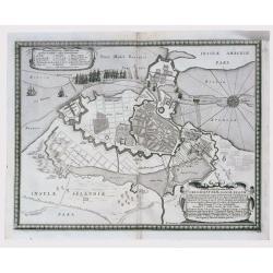
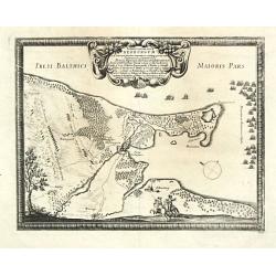
Accurata Delineatio Oppugnatae a Federatis, Caesareis, Polonicis, Danicis...
This beautiful bird’s-eye map shows part of the Danish island of Fyn and Jutland with Swedish, Polish and Danish forces in the Baltic. A lettered key identifies 12 locati...
Date: Nuremburg, 1696
Selling price: ????
Please login to see price!
Sold in 2016
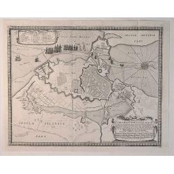
Accurata Delineatio Castrorum Suecicorum ut et Haffniae
A bird’s-eye view of an important battle for the defending of Copenhagen, Denmark. With very attractive decorative cartouches, a compass rose, and a border and featuring ...
Date: Nuremburg, 1696
Selling price: ????
Please login to see price!
Sold in 2016
Isola Di Mayen Scoperta l'Anno 1614 . . .
A fine map of Jan Mayen Island, which was discovered in 1614 by a Dutch whaling captain, northeast of Iceland.A large volcano is shown. The map has many Dutch names.The r...
Date: Venice, 1696
Selling price: ????
Please login to see price!
Sold in 2020
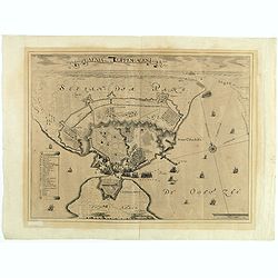
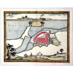
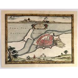
Ichnographia Areis et Oppidi Nicoplae.
A striking city map of Nykobilg, Denmark by Pufendorf in 1696. Freiherr Samuel von Pufendorf (1632–1694) was a German jurist, political philosopher, economist and histori...
Date: Stockholm, 1696
Selling price: ????
Please login to see price!
Sold in 2023
Accuratissima..Sueciae, Daniae et Norvegiae, Tabula.
Signed lower right with privilege. A delicately colored map of Scandinavia with a large title cartouche.
Date: Amsterdam 1696
Selling price: ????
Please login to see price!
Sold
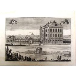
Prospectus Euripi e Palatio Rosersberg.
Two striking copper engravings featuring the Rosersberg Palace. Engraved by Swiddle in 1696.Count Erik Dahlberg (1625-1703) was a Swedish soldier, engineer and graphic a...
Date: Stockholm, 1696
Selling price: ????
Please login to see price!
Sold in 2017
Accuratissima regnorum Sueciae, Daniae et Norvegiae, Tabula.
Uncommon map of Scandinavia with a large title cartouche in upper left corner. Signed lower right with privilege.Including Sweden, Denmark, Norway and small part of Russi...
Date: Amsterdam, 1696
Selling price: ????
Please login to see price!
Sold in 2011
Delineatio Geometrica Urbis Haffniæ, Daniæ Regum ...
Detailed copper engraved map featuring a panoramic view of Copenhagen, Capital of Denmark, besieged by Swedish forces from 11th (21st) August 1658. This time instead of c...
Date: Nuremburg, 1696
Selling price: ????
Please login to see price!
Sold in 2020
Delineatio Geometrica Urbis Haffniae Daniae Regum.
A bird's-eye plan of the important fort defending Copenhagen. The Danish navy fills the sea, and the map is adorned with decorative title and key cartouches and a detaile...
Date: Stockholm, 1696
Selling price: ????
Please login to see price!
Sold in 2020
Nackschovia lulandiae Oppidum
A beautiful engraved plan of the fortified town of Nakskov Lolland Island in Demnark. Engraved on copper with a view of the fortress. With a floral title cartouche and pi...
Date: Stockholm, 1697
Selling price: ????
Please login to see price!
Sold in 2016
Baltus minor / Koldinger fiord.
From Pufendorf's famous chronicle on the Baltic area, ' Histoire du règne de Charles Gustave, roy de Suède'A map of the Lille Belt near Kolding.
Date: Nürnberg, C. Riegel, 1697
Selling price: ????
Please login to see price!
Sold in 2008
Typus Solemnitatum quibus Tabula pacis inter regna Sueciae et Daniae.
From Pufendorf's famous chronicle on the Baltic area, ' Histoire du règne de Charles Gustave, roy de Suède'
Date: Nürnberg, C. Riegel, 1697
Selling price: ????
Please login to see price!
Sold in 2008
Situs locorum circa neoburgum in Fionia
From Pufendorf's famous chronicle on the Baltic area, ' Histoire du règne de Charles Gustave, roy de Suède'A map of Nyborg and vincinity on the island of Funen.
Date: Nürnberg, C. Riegel, 1697
Selling price: ????
Please login to see price!
Sold in 2010
Delineatio Geometrica Urbis Haffniae Daniae Regnum.
From Pufendorf's famous chronicle on the Baltic area, ' Histoire du règne de Charles Gustave, roy de Suède'
Date: Nürnberg, C. Riegel, 1697
Selling price: ????
Please login to see price!
Sold
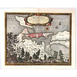
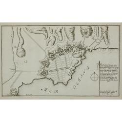
Ichnographia Oppidi et Munimenti Christianopolis ...
Kristianopel, at the eastern end of the province of Blekinge, was founded in 1603 by King Christian IV of Denmark as a defense against Swedish attacks. The province of Bl...
Date: Nuremberg, 1697
Selling price: ????
Please login to see price!
Sold in 2019
Castra Suedica ad Fridirici Uddam.
From Pufendorf's famous chronicle on the Baltic area, ' Histoire du règne de Charles Gustave, roy de Suède'The Swedish fortifications in front of Fredericia, 1657.
Date: Nürnberg, C. Riegel, 1697
Selling price: ????
Please login to see price!
Sold in 2008
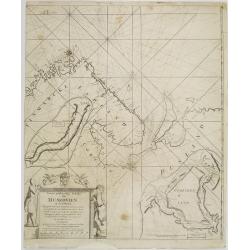
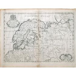
Nieuwe gelyk-gradige Paskaart van Muskovien in grootbestek. Begrypende Noorwegen, Finmarken, Lapland en Rusland. Strekkende van Hitland tot Ysland, Beren Yland. . .
Rare sea chart map of ?Muskovien?: comprising northern parts of Norway, Finland and Russia, with insets of Kola peninsula and the course of the Archangel (Dwina) rivers. ...
Date: Amsterdam, 1697
Selling price: ????
Please login to see price!
Sold in 2008
Saswestaholm & Sioosa.
A lovely copper engraving of two prominent buildings in Sweden by Dahlberg. There are two decorative coasts of arms held by putti. Count Erik Dahlberg (1625-1703) was a S...
Date: Stockholm, 1697
Selling price: ????
Please login to see price!
Sold in 2017
Ichnogrphia Nakscoviae.
Fine decorative map from Samuel Pufendorfs large description of the Swedish King Karl X Gustav's campaign in Poland, Germany and Denmark in the years 1655-1660. Erik Dahl...
Date: Sweden, 1697
Selling price: ????
Please login to see price!
Sold in 2018
Accurata Delineatio Geometrica in Luthia Friderici Oddae
A striking map of Fredericia in Demnark. Engraved on copper with a view of three ships in the sea. With a decorative drapery title cartouche and picture frame borders. A...
Date: Stockholm, 1697
Selling price: ????
Please login to see price!
Sold in 2018
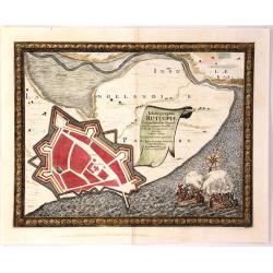
Ichnographia Rutcopiae Langelandice Oppidi
A beautifully engraved plan of the fortified town of Rutkioping on the Danish island of Langeland. Fully engraved sea with two large rowboats filled with sailors engaged ...
Date: Stockholm, 1697
Selling price: ????
Please login to see price!
Sold in 2018
Situs Iocorum Circa Neoburgum in Fiona
A beautiful engraved plan of Nybirg Fyn in Demnark. Engraved on copper with a view of two men on horseback. With a decorative title cartouche and picture frame borders. A...
Date: Stockholm, 1697
Selling price: ????
Please login to see price!
Sold in 2018
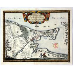
Nackschouia Lalandia Oppidium.
Old map of the Nakskov area of Denmark - Nakscoviae - by Pufendorf/ Dahlberg 1697. It is in Lolland municipality in Region Sjælland on the western coast of the island of ...
Date: Sweden, 1697
Selling price: ????
Please login to see price!
Sold in 2017
Regni Daniae Novissima et Accuratissima Tabula.
An uncommon issue of the magnificent map of all of Denmark and the tip of Sweden. The land is fully engraved with mountains, forests and cities, while the sea is filled w...
Date: Amsterdam 1698
Selling price: ????
Please login to see price!
Sold
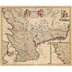
![[Map of Scandinavia] La Scandinavie, et les Environs.](/uploads/cache/82018-250x250.jpg)
[Map of Scandinavia] La Scandinavie, et les Environs.
An attractive large-format map of Scandinavia. Embellished with two cartouches by Jaillot, H-J.
Date: Paris, ca 1700
Selling price: ????
Please login to see price!
Sold in 2019
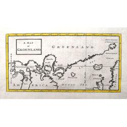
A Map of Groenland.
A scarce map of the southern coast of Greenland and the north Atlantic Ocean. The map is derived from Isaac la Peyrere's map of 1647. It locates Spitzberg, Iceland, the f...
Date: London, ca 1700
Selling price: ????
Please login to see price!
Sold in 2018
A New Map of Denmark, Norway, Sweden, & Moscovy shewing their present general divisions, chief cities or towns, rivers and mountains & c.
Fine map of Scandinavia and Russia from 1700, dedicated to the Duke of Glocester. Cartouche with English coat of arms is in the upper left corner.
Date: London, 1700
Selling price: ????
Please login to see price!
Sold in 2010
A New Map of Ancient Scandinavia together with as much more of y Northern Part of Ancient Europe as Anvers to Present Denmark & Moscovia
Map of Scandinavia, with an inset map of Denmark, from Edward Wells' "A New Sett Of Mapps Of Ancient And Present Geography ..." Wells was a teacher of mathemati...
Date: Oxford, 1700
Selling price: ????
Please login to see price!
Sold in 2010
