Browse Listings in Europe > Scandinavia
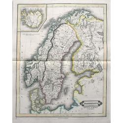
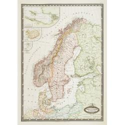
Scandinavia including Sweden, Norway & Denmark.
An excellent steel engraved map of Scandinavia, including the Baltics and St. Petersburg. An inset map shows Iceland.
Date: Edinburgh, ca 1831
Selling price: ????
Please login to see price!
Sold in 2019
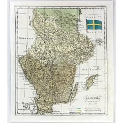
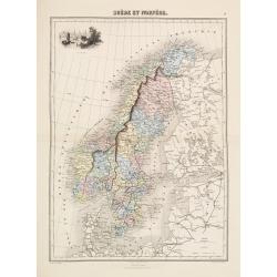
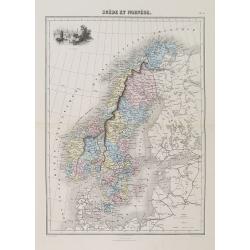
La Svezia e la Gotia.
A fine map of Sweden by Francesco Constantino Marmocchi. It is from the atlas "Atlante di Geogrfia Universale" published in Florence in 1838. The map features a...
Date: Florence, 1838
Selling price: ????
Please login to see price!
Sold in 2016
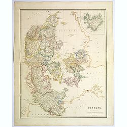
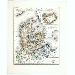
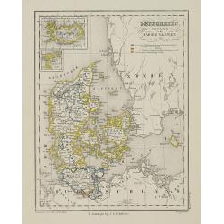
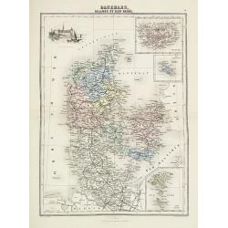
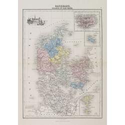
Denmark.
An attractive steel engraved map of Denmark, with an inset map of Iceland, which was then a Danish dependency. Many place names and physical features shown.The Arrowsmith...
Date: London, 1839
Selling price: ????
Please login to see price!
Sold in 2017
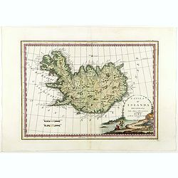
L'Isola d'Islanda Delineata Sulle ultime osservazioni.
Cassini’s splendid map depicts Iceland at the end of the eighteenth century. Though Iceland was geographically isolated from the European continent, for centuries it was ...
Date: Rome, 1796- before 1839
Selling price: ????
Please login to see price!
Sold in 2018
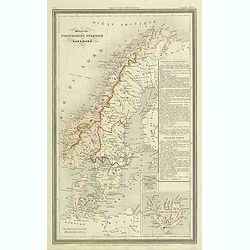
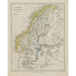
Monarchie Norvegieno Suedoise et Danemark.
Finely engraved map of Scandinavia, including Norway, Sweden, Denmark with insets of Iceland and Faroe Islands, prepared by A.H.Dufour and engraved by Giraldon-Bovinet. P...
Date: Paris, Jules Renouard, ca.1840
Selling price: ????
Please login to see price!
Sold in 2012
![[Three S.D.U.K. Scandinavian Maps.]](/uploads/cache/96036-250x250.jpg)
[Three S.D.U.K. Scandinavian Maps.]
Three Scandinavian SDUK maps including:1) Denmark and part of Norway.2) The southern Provinces of Sweden (Sverige).3) Sweden, Norway and Denmark.Published by the "So...
Date: London, 1841
Selling price: ????
Please login to see price!
Sold in 2016
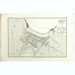
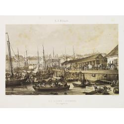
Plan de Reykjavík.
Detailed plan of Reykjavík from 'Voyage en Islande et au Groenland' by M. Paul Gaimard, published in Paris 1842. Engraved by Ambroise Tardieu' after 'V. Lottin'. Paul Gai...
Date: Paris, 1842
Selling price: ????
Please login to see price!
Sold in 2019
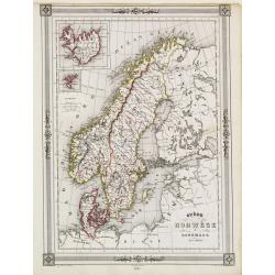
Chart of the Straits Between Denmark and Sweden Shewing the Passage from the Kattegat through
"Decorative map of Scandinavia, with inset map of Iceland and the Faeroe Islands, prepared by J.G.Barbié du Bocage.Engraved by Ch.Smith, published by Basset who was ...
Date: Paris 1846
Selling price: ????
Please login to see price!
Sold
Neueste Karte von Danemark mit Holstein und Lauenburg. . .
A detailed regional map of Denmark, with inset map of the Danish dependency of Iceland. Administrative boundaries hand col. Relief shown by hachures. From Meyer's Hand At...
Date: Hildburghausen, 1846
Selling price: ????
Please login to see price!
Sold in 2021
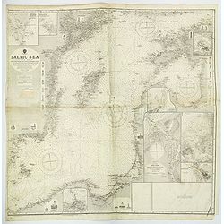
Mepkatopckar... (Title in Russian : Baltic Sea east of Helsinki with Kotka and the Islands of Gogland and Moshchny.)
This rare chart of the Baltic Sea east of Helsinki with Kotka and the Islands of Gogland and Moshchny until the Russian coast. Based on the work of Gavril Andreyevich Sar...
Date: Saint Petersburg, 1848
Selling price: ????
Please login to see price!
Sold in 2011
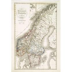
Karta öfver Sverige och Norrige.
An very rare and detailed map of Sweden and Norway with Swedish text. This is an heavenly updated version of P.B.Skölberg map of 1840 and engraved by C.Anderson in 1847.F...
Date: A. Wiborgs förlag, Stockholm, ca. 1848
Selling price: ????
Please login to see price!
Sold in 2019
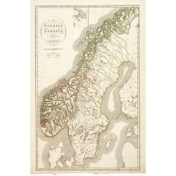
Karta öfver Sverige och Norrige.
An very rare and detailed map of Sweden and Norway with Swedish text. This is an heavenly updated version of P.B.Skölberg map of 1840 and engraved by C.Anderson in 1847.F...
Date: A. Wiborgs förlag, Stockholm, ca. 1848
Selling price: ????
Please login to see price!
Sold in 2018
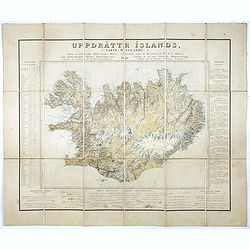
Uppdráttr Íslands / Carte d'Islande.
This rare and highly engaging map represents the first integrated (single-sheet) edition of Iceland's first accurate topographical map. Long considered among the most “c...
Date: Copenhagen, 1849
Selling price: ????
Please login to see price!
Sold in 2016
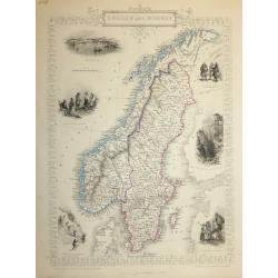
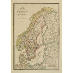
SWEDEN AND NORWAY
A highly detailed and decorative map of Norway and Sweden issued by John Tallis. Published in London, Edinburgh and Dublin circa 1850.The map has an elaborate border, and...
Date: London, 1850
Selling price: ????
Please login to see price!
Sold in 2016
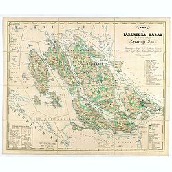
Karta öfver Färentuna härad eller det fordom så kallade Svartsjö län,
Fine and detailed map prepared by Victor Dahlgren (1815-1870).
Date: Stockholm, 1853
Selling price: ????
Please login to see price!
Sold in 2025
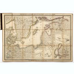
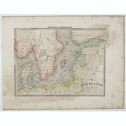
Theatre de la guerre dans la Baltique, par Mr. le Colonel LAPIE.
Excellent detailed folding map of the Baltic Sea. With inset map of Finland in lower right (195x185mm.) and inset plans of "Environs de Riga", "Plan de la ...
Date: Paris, 1854
Selling price: ????
Please login to see price!
Sold in 2014
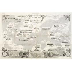
Picture map of the Baltic sea.
Large wood block engraved map of the Baltic Sea and adjacent countries (Denmark, Sweden, Finland, Estonia, Latvia, Lithuania, Poland, Germany) with numerous vignettes to ...
Date: London, 1856
Selling price: ????
Please login to see price!
Sold in 2014
Mar Batilco sur isole e Paesi Circonstanti . . .
Uncommon map of Baltic Sea prepared by Francesco Costantino Marmocchi. Above the map "Geografia Commerciale". From "Il Globo Atlante di carte Geografiche c...
Date: Genova, Paolo Rivara fu Giacomo, 1858
Selling price: ????
Please login to see price!
Sold in 2020

Le Dôme de Lund (Suède).
Uncommon and decorative lithography published by Carl Johan Billmark and printed by Lemercier in Paris, 55 rue de Seine, the leading firm in Europe at that time. From: It...
Date: Paris, c.1859
Selling price: ????
Please login to see price!
Sold
Bla Slussen i Stockholm.
Uncommon and decorative lithography of Stockholm, published by Carl Johan Billmark and printed by Lemercier in Paris, 55 rue de Seine, the leading firm in Europe at that ...
Date: Paris, c.1859
Selling price: ????
Please login to see price!
Sold
Denemarken Ijsland en de Faroër Eilanden.
Uncommon map of Denmark with inset map of Iceland. Lithography by J.H. van Weijer, published in Atlas der geheele Aarde [?] in 24 kaarten. With colored key to processions...
Date: Groningen, ca. 1860
Selling price: ????
Please login to see price!
Sold in 2008
Zweden en Noorwegen.
Uncommon map of Norway and Sweden. Lithography by J.H. van Weijer, published in Atlas der geheele Aarde [?] in 24 kaarten.
Date: Groningen, ca. 1860
Selling price: ????
Please login to see price!
Sold in 2008
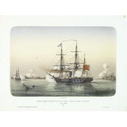
Division anglaise détruisant les forts des Russes à l'entrée du Golfe de Finlande.
Showing two English ships attaching a Russian stronghold in the Gulf of Finland during June 1854. The Crimean War (1854-1856) between Russia on one side and the alliance ...
Date: Paris, 1860
Selling price: ????
Please login to see price!
Sold in 2014
Suede et Norvege. Danemark.
Very detailed map from "Atlas Spherodidal & Universel de geographie," Prepared by F.A.Garnier and edited by Jules Renouard, rue de Tournon, Paris. Uncommon ...
Date: Paris 1861
Selling price: ????
Please login to see price!
Sold
A new map of Sweden and Norway.
Very detailed map of Sweden, Norway, Denmark and Finland. Indicated are railways and Canals.James Wyld (the younger) was geographer to the Queen and H.R.H. Prince Albert....
Date: London, 1855/1864
Selling price: ????
Please login to see price!
Sold in 2018
Carte réduite de l'Islande et des Iles Feroë. . . N°837.
Sea of Iceland and the Faroes Islands.Lighthouses are colored by hand in red and yellow. It shows soundings, anchorage's, channels, shoals, navigational sightings.
Date: Paris, 1872
Selling price: ????
Please login to see price!
Sold in 2015
Suède et Norvége.
Decorative map of the Sweden and Norway from Géographie Universelle, Atlas Migeon. published by J. Migeon. Engraving by Schroeder of a view of the Stockholm in the upper ...
Date: Paris 1874
Selling price: ????
Please login to see price!
Sold
Danemark
Decorative map of the Denmark from Géographie Universelle, Atlas Migeon. published by J. Migeon. Engraved by Schroeder of a view of the castle of Kroneburg in the upper l...
Date: Paris, 1874
Selling price: ????
Please login to see price!
Sold in 2019
Suède et Norvège.
A decorative map of Sweden and Norway from Géographie Universelle, Atlas Migeon, published by J. Migeon. With an engraving of Stockholm upper left corner.From one of the ...
Date: Paris, 1874
Selling price: ????
Please login to see price!
Sold in 2012
Danemark, Islande et Iles Faeröe.
A decorative map of Denmark, Iceland and the Faroe Islands from Géographie Universelle, Atlas Migeon. published by J. Migeon. With an engraving of the Kronborgh Castle up...
Date: Paris, 1874
Selling price: ????
Please login to see price!
Sold in 2013
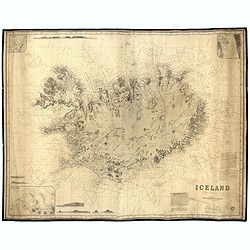
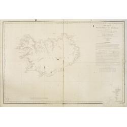
Iceland - Chart No. 114.
Very rare and large English nautical chart, consisting of two pages, compiled by James Imray. The bottom right the map has the title and pasted information about the 'Sou...
Date: Londen, 1910
Selling price: ????
Please login to see price!
Sold in 2023
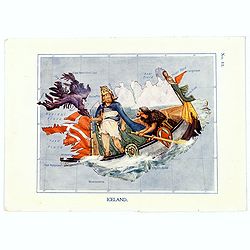
Iceland.
A fun and unusual map of Iceland, in the shape of the Story of the Vikings. Map No. 11, in good printed color, shows fjords, and some towns. Lines of longitude and latitu...
Date: London, 1912
Selling price: ????
Please login to see price!
Sold in 2017
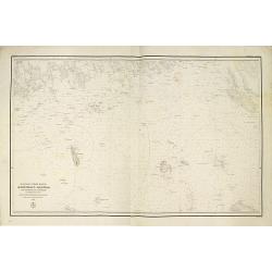
Baltic Sea Eastern SheetCompiled from Swedish German and Russian Government Surveys. . .
A large and detailed Admiralty chart first published in 1862, but with numerous revisions and editions up until 1921. Map of the Baltic Sea, covering some of the Gulf of ...
Date: London, 1921
Selling price: ????
Please login to see price!
Sold in 2019
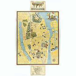
Kobenhavn / North Seeland.
A nice, large, colorful town plan of the Danish capital, published in 1946. The map covers in some detail from the central train station and the Tivoli Gardens, north up ...
Date: Kobenhavn, 1946
Selling price: ????
Please login to see price!
Sold in 2018
