Browse Listings in Europe > Scandinavia > Norway
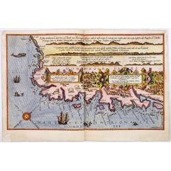
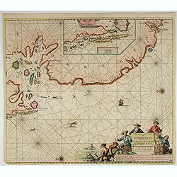
Die zee custe van Noorweghen tusschen der Noess en Mardou. . .
A rare Dutch text edition of this early and detailed chart of the coast of Norway. Decorated by a colorful title cartouche and scale cartouche, one compass rose, several ...
Date: Leiden, Plantijn, 1585
Selling price: ????
Please login to see price!
Sold in 2024
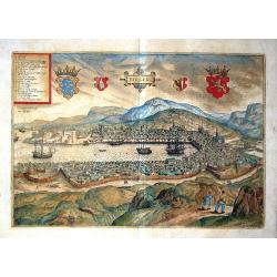
Bergen.
A spectacular, large, rare view of Bergen, from the famous 'Civitates Orbis Terrarum' of Braun & Hogenberg. Bergen was founded in 1070, during the warm medieval perio...
Date: Cologne, 1590
Selling price: ????
Please login to see price!
Sold in 2018
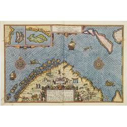
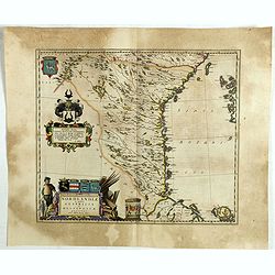
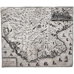
Hydrographica Septentrionalis Norvegiae partis descriptio. . . / Beschrijvinghe der Zeecusten vant Nordelicxste deel van Norweghen. . .
A detailed chart of the coast of Norway and Lapland. Decorated by a colorful title cartouche and scale cartouche, two compass roses, several vessels and sea monsters, and...
Date: Amsterdam, C.Claesz, 1596
Selling price: ????
Please login to see price!
Sold in 2008
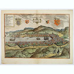
Bergen.
The delightful Braun & Hogenberg bird's-eye view of the Norwegian city of Bergen, founded in 1070 and fortified with a palisade, is seen from the southwest across Vàg...
Date: Cologne, 1588-1597
Selling price: ????
Please login to see price!
Sold in 2018
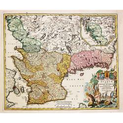
Nova et accurata tabula Episcopatuum Stavangriensis, Bergensis et Asloiensis.
Fine map of the southern part of Norway. Decorated with many ships and a compass rose. Latin text on verso. From a French composite atlas.
Date: Amsterdam, 1636
Selling price: ????
Please login to see price!
Sold in 2012
Nova et accurata tabula Episcopatuum Stavangriensis, Bergensis et Asloiensis.
Fine map of the southern part of Norway. Decorated with many ships and a compass rose. German text on verso.
Date: Amsterdam, 1636
Selling price: ????
Please login to see price!
Sold in 2012
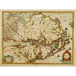
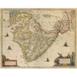
Nova et accurata Tabula Episcopatuum Stavangriensis, Bergensis et Asloiensis Vicinarumque aliquot territoriorum
Original old colored map of southern Norway by J. Janssonius. Showing the area between Oslo, Stavanger and Bergen. Decorated with a figural cartouche with mileage scale, ...
Date: Amsterdam, 1636
Selling price: ????
Please login to see price!
Sold in 2009
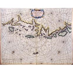
Tabula Portuum Occidentalium Norwegiae et Spizbergi.
Copper engraving sea chart, printed from 2 plates, by M. Merian from J. A. à Werdenhagen, "De rebus publicis Hanseaticis tractatus". Very decorative cartouche.
Date: Frankfurt, 1641
Selling price: ????
Please login to see price!
Sold in 2018
Dioecesis Stavangriensis.
Stavanger by Blaeu. Latin text on verso.
Date: Amsterdam, 1640-1644
Selling price: ????
Please login to see price!
Sold in 2009
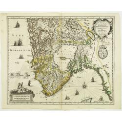
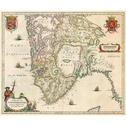
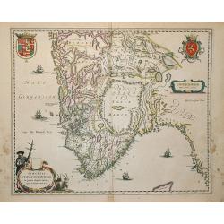
Dioecensis Stavangriensis..
Fine decorative map of southern Norway from 61 deg. N. Oslo, Stavanger and Bergen prominently shown. The map presents a vivid view of the fjords and mountains topography ...
Date: Amsterdam, 1644
Selling price: ????
Please login to see price!
Sold in 2018
Nova ..Stavangriensis, Bergensis et Asloiensis..
Fine map of the southern part of Norway. Decorated with many ships and a compass rose.
Date: Amsterdam 1639-1644
Selling price: ????
Please login to see price!
Sold
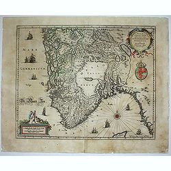
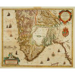
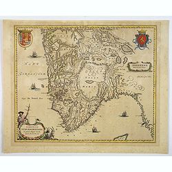
Dioecensis Stavangriensis, Apud Joh. et Cornel. Blaeu.
Fine decorative map of southern Norway from 61 deg. N. Oslo, Stavanger and Bergen prominently shown. The map presents a vivid view of the fjords and mountains topography ...
Date: Amsterdam, 1644
Selling price: ????
Please login to see price!
Sold
Uplandia.
Covers the area of the modern Uppsala, the vicinity of Stockholm, and includes most of Aland.
Date: Amsterdam 1639-1644
Selling price: ????
Please login to see price!
Sold
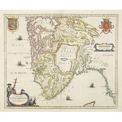
Dioecenis Stavangriensis . . .
Map of Southern Norway with Bergen and Stavanger.
Date: Amsterdam, 1650
Selling price: ????
Please login to see price!
Sold in 2011
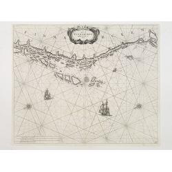
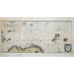
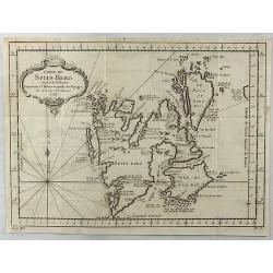
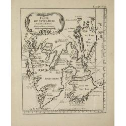
De Cust van Finmarcken tusschen Dronten en Sanien.
Uncommon chart of the coasts of Finnmark, centered on the Moskstraumen (popularly known as the Maelstrom) one of the strongest whirlpools in the world, that forms in a st...
Date: Amsterdam 1650
Selling price: ????
Please login to see price!
Sold
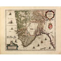
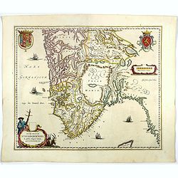
Dioecensis Stavangriensis. . .
A fine and decorative map of southern Norway from 61 deg. N. with Oslo, Stavanger and Bergen prominently shown. The map presents a vivid view of the fjords and mountains ...
Date: Amsterdam, ca 1660
Selling price: ????
Please login to see price!
Sold in 2019
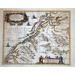
Nordlandiae et quibies Gestricia et Helsingicae regiones.
It shows the east central part of Sweden Gästrikland and Hälsingland). The body of water to the east is the Gulf of Bothnia.The map is enhanced by a number of decorative ...
Date: Amsterdam, 1661
Selling price: ????
Please login to see price!
Sold in 2019
Episcopatus Stavangriae pars Australis.
South Stavanger from Blaeu's Major atlas.
Date: Amsterdam, 1662
Selling price: ????
Please login to see price!
Sold in 2009
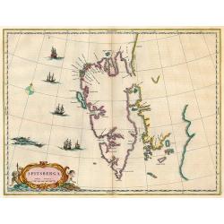
Spitsberga.
Nice copy of Blaeu's map of Spitsbergen.
Date: Amsterdam, 1662
Selling price: ????
Please login to see price!
Sold in 2009
Caarte van Finmarcken van 't Eylandt Sanien tot Noordkyn...
Uncommon chart depicting the coast of Finnmark, in Norway.A decorative title cartouche, rhumb lines, three vessels and two compass roses. Published 1666 by J. Theunisz an...
Date: Amsterdam, 1666
Selling price: ????
Please login to see price!
Sold in 2018
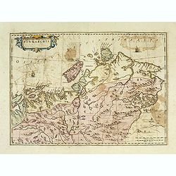
Finmarchia.
The map of Finnmark and northernmost Lapland based on the Great Scandinavian Atlas of Anders Bure (1626). This map was published in a Spanish text edition of the multi-vo...
Date: Amsterdam, 1672
Selling price: ????
Please login to see price!
Sold in 2014
Caerte van Noorwegen vande hoeck van Horrel tot aen Momendael, waer in begrepen wert het Liet van Dronten.
A rare sea Chart shows part of the Norwegian coast, from Horrel to Trondheim. Nice original colors.
Date: Amsterdam, 1680
Selling price: ????
Please login to see price!
Sold in 2018
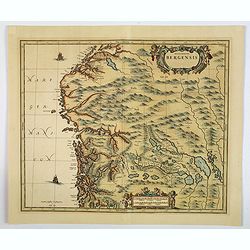
Episcopatus Bergensis.
An uncommon issue of Janssonius' map of the area around Bergen, in Norway, first issued in 1658. After Jansson's death in 1664 the plate came into the possession of his s...
Date: Oxford, ca 1680
Selling price: ????
Please login to see price!
Sold in 2019
Dioecesis Trundhemiensis pars Australis.
From his "Atlas major, sive, Cosmographia universalis, adeoque orbis terrestris, maritimus, antiquus & coelestis : in quo tabulae cum descriptionibus omnium regi...
Date: Oxford, 1682
Selling price: ????
Please login to see price!
Sold in 2014
Pas-Kaert van de Cust van Noorwegen Beginnende van Der Neus tot aen Bommel Sond.
Very decorative sea chart of Norway by J. Van Keulen, shows VVest Agder and Rogaland, oriented to the East. Plate number 12 in lower right corner.Inset chart: Pascaertie ...
Date: Amsterdam, 1700
Selling price: ????
Please login to see price!
Sold in 2022
Regni Norvegiæ Nova et Accurata descriptio.
A very rare, decorative map of Norway with inset battle scene and many ships sailing along the coast. The map was included in the fall 1716 issue of Relationis Historicæ ...
Date: Frankfurt, 1716
Selling price: ????
Please login to see price!
Sold in 2020
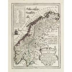
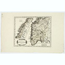
Le Royaume de Norwege Divisé en ses cinq Principaux Gouvernements..
Lovely small map of Norway, with much of Sweden to the East, vessel and sea monsters in the Norwegian Sea.It shows a text table in the upper left corner containing the na...
Date: Paris, 1719
Selling price: ????
Please login to see price!
Sold in 2017
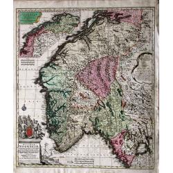
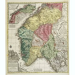
Norvegiae Accurata Tabula in qua Praefecturae quinque Generales. . .
Johann Baptist Homann's well-engraved map has a large decorative cartouche. Detailed map of Norway. The southern part of the country is the focus of the main map, while t...
Date: Nuremberg, ca. 1730
Selling price: ????
Please login to see price!
Sold in 2020
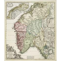
Norwegiae accurata et novissima delineatione...
Seutter important map of Norway: it shows the country in great detail. Included are also small parts of Sweden. The northernmost part of Norway is delineated within an in...
Date: Augsburg, 1740
Selling price: ????
Please login to see price!
Sold in 2017
Regni Norvegiae Nova Tabula in Quinque Praefecturas Generalis. Aggerhusiensem, Bergensem, Nidrosiensem, Warhusiae et
A re-issue by Covens and Mortier of the copperplate by Frederick de Wit. The copperplate lines were carefully redone and their address added to the scales in lower center...
Date: Amsterdam c. 1744
Selling price: ????
Please login to see price!
Sold in 2009
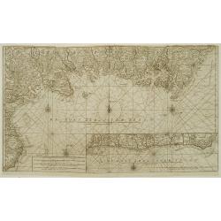
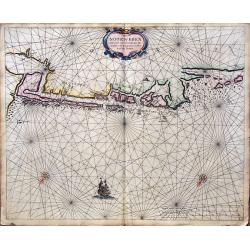
De Oost zee of Öster Siöön.
Latitude scale, compass rose and system of rhumb lines, soundings, anchorage's, etc. A wealth of cities and information appear in the chart.Printed on two joined sheets o...
Date: Amsterdam 1753
Selling price: ????
Please login to see price!
Sold
Carte de Spits-Berg Suivant les Hollandois.
A detailed map of Spitsbergen with the adjacent islands; the largest permanently populated island of the Svalbard Archipeligo in Norway. It features a French style decor...
Date: Paris, 1758
Selling price: ????
Please login to see price!
Sold in 2018
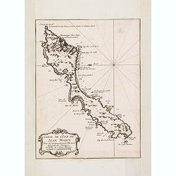
Carte de L'Isle de Jean Mayen. . .
Charming map of Jan Mayen Island, a volcanic island in the Arctic Ocean and part of the Kingdom of Norway. Several sounding shown.From Prevost's l'Histoire générale des v...
Date: Paris, 1758
Selling price: ????
Please login to see price!
Sold in 2016
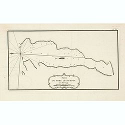
Plan du port d'Ingeson en Norvege.
Charming map of the Porsangerfjorden in northern Norway. The 123-kilometre long fjord is Norway's fourth longest fjord. It is located in the municipalities of Nordkapp an...
Date: Paris, 1758
Selling price: ????
Please login to see price!
Sold in 2021
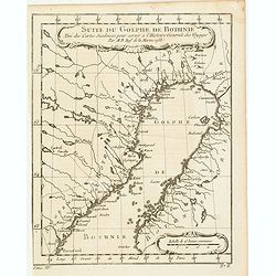
Suite du Golphe de Bothnie. . .
Charming map of the northernmost portion of the Golf of Bothnia, which separates Sweden and Finland. Several sounding shown.From Prevost's l'Histoire générale des voyages...
Date: Paris, 1758
Selling price: ????
Please login to see price!
Sold in 2018
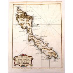
Carte de L'Isle de Jean Mayen.
Fine little copper engraved, hand colored map of the Island of Jean Mayen, off the coast of Norway. It was by Bellin. Features a decorative title cartouche.
Date: Paris, 1760
Selling price: ????
Please login to see price!
Sold in 2016
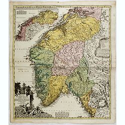
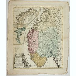
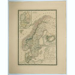
Nova Tabula Scaniae, que est Gothia Australis Provincias Scaniam, Hallandiam et Blekingiam.
Nova Tabula Scaniae, que est Gothia Australis Provincias Scaniam, Hallandiam et Blekingiam. Johan Baptist Homann (1663-1724). Outstanding German cartographer. Founder o...
Date: Nürnberg, 1762
Selling price: ????
Please login to see price!
Sold in 2021
Carte du Spits-Berg
This map is from ''''Petit Atlas Maritime'''' and was etched by Croisey.
Date: 1764
Selling price: ????
Please login to see price!
Sold in 2008
Regnum Norwegiae accurata et novissima delineatione?
Uncommon map of Norway. T.C. Lotter married M. Seutter's daughter in 1740 and succeeded him in 1756. Lotter used the copperplate of Seutter, he only changed the name.
Date: Augsbourg, 1770
Selling price: ????
Please login to see price!
Sold
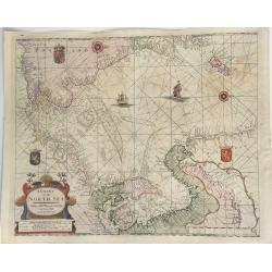
A Chart of the North Sea.
This extremely rare, large sea chart depicts the European North Sea. It is probably the last and possibly unrecorded state of the sea charts of the North Sea produced by ...
Date: London, ca 1770
Selling price: ????
Please login to see price!
Sold in 2023
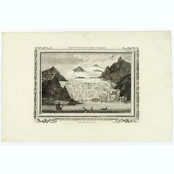
View of an Iceberg in the Island of Spitsbergen.
An attractive, and unusual engraving by C. Stalker, for Hervey's New System of Geography. The print shows a large Iceberg in between mountains on the Arctic island of Spi...
Date: London, 1787
Selling price: ????
Please login to see price!
Sold in 2018
Charte vom Konigreich Norwegen . . .
Decorative map of Kingdom of Norway and the Faroe Islands (Faroese map inserted by C.G. Mengel). According to O.A.Wangensteens and some other charts of the Büschingian ge...
Date: Nurenberg, 1789
Selling price: ????
Please login to see price!
Sold in 2022
La Norvegia divisa Nelle Sue, Provincie Di nuova Projezione.
A fine large map of Norway, engraved by Zuliani after Pitteri. Few maps of Norway on its own were published during this period. Map shows the country divided into its pro...
Date: Venice, 1791
Selling price: ????
Please login to see price!
Sold in 2019
La Norvegia divisa Nelle Sue, Provincie Di nuova Projezione.
A fine large map of Norway, engraved by Zuliani after Pitteri. Few maps of Norway on its own were published during this period. Map shows the country divided into its pro...
Date: Venice, 1791
Selling price: ????
Please login to see price!
Sold in 2022
Das Konigreich Norwegen.
Von Reilly's map of Norway, published in the ‘Schauplatz der fünf Theile der Welt, Vienna, 1792. It shows central and southern Norway, with the northern half as an inset....
Date: Vienna, 1792
Selling price: ????
Please login to see price!
Sold in 2021
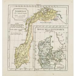
Norwege. . .
Map of Norway., with inset map of Denmark.By C. F. Delamarche, successor of Robert de Vaugondy, Geographer.
Date: Paris, 1794 - 1806
Selling price: ????
Please login to see price!
Sold in 2023
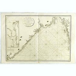
Carte particulière de la côte de Norwége, à l'est de Flekkeröe et Christiansand, avec partie de la côte de Suède jusqu'à. . .
Large sea chart showing northern part of Skagerrak with the coast of Norway with Kristiansand till Frederiksted and the Swedish coast till just north of Gothenburg. The c...
Date: Paris, 1812
Selling price: ????
Please login to see price!
Sold in 2018
Carte Generale des Royaumes de Suede, de Norvege et de la Danemark.
A fine and detailed large map of the region with insets of Denmark, Faroe Islands, and Iceland. A scroll style title with the embossed royal seal, a keyboard style border...
Date: Paris, 1825
Selling price: ????
Please login to see price!
Sold in 2021
![[ Spitzbergen ]](/uploads/cache/27540-250x250.jpg)
[ Spitzbergen ]
Uncommon aquatint depicting the southern bay of Spitzbergen, engraved by Fumagalli. From Giulio Ferrario's work Le Costume Ancien et Moderne ou Histoire du gouvernement, ...
Date: Milan, 1827
Selling price: ????
Please login to see price!
Sold in 2020
