Browse Listings in Europe > Russia / Baltic / Black Sea region
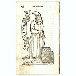
Eine Ostiackin.
Finely executed wood block print taken from the "Neueröffnetes Amphitheatrum Worinnen. . .", which book was issued in five parts between 1722 and 1728, with vo...
Date: Erfurt, ca. 1724
Selling price: ????
Please login to see price!
Sold in 2016
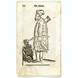
Ein Ostiacke.
Finely executed wood block print taken from the "Neueröffnetes Amphitheatrum Worinnen. . .", which book was issued in five parts between 1722 and 1728, with vo...
Date: Erfurt, ca. 1724
Selling price: ????
Please login to see price!
Sold in 2016
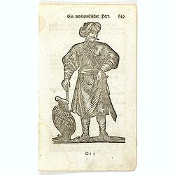
Ein Muscovitischer Herr.
Finely executed wood block print taken from the "Neueröffnetes Amphitheatrum Worinnen. . .", which book was issued in five parts between 1722 and 1728, with vo...
Date: Erfurt, ca. 1724
Selling price: ????
Please login to see price!
Sold in 2016
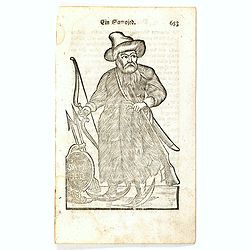
Ein Samojed.
Finely executed wood block print taken from the "Neueröffnetes Amphitheatrum Worinnen. . .", which book was issued in five parts between 1722 and 1728, with vo...
Date: Erfurt, ca. 1724
Selling price: ????
Please login to see price!
Sold in 2016

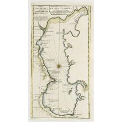
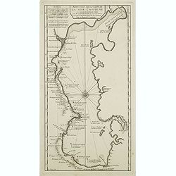
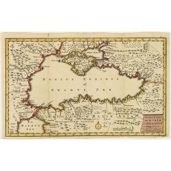
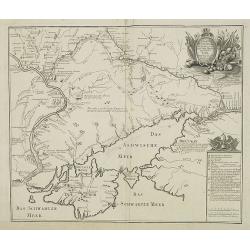
Carte Marine De La Mer Caspiene levée suivant les ordres de S.M.Cz. En 1719, 1720 et 1721.
Detailed of the Caspian Sea, prepared by Karl van Verden in 1722. Van Verden was a Russian sailor and the Czar's Special Commander, who produced the first accurate map of...
Date: Paris, ca. 1725
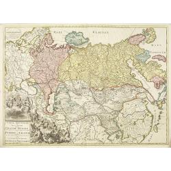
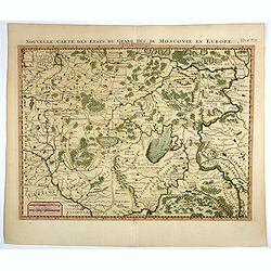
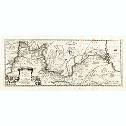
Carte nouvelle de tout l'empire de la grande Russie dans l'estat ou il s'est trouvé à la.mort de Pierre le Grand. . .
Rare map showing the Empire of Peter I the Great at the time of his death in 1723. Lower right a large title cartouche with a portrait of Peter I the Great or Pyotr Alexe...
Date: Amsterdam, ca. 1723-1725
Selling price: ????
Please login to see price!
Sold in 2010
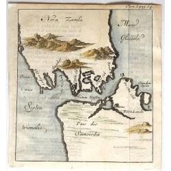
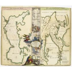
Nova Zemla.
Unusual, detailed, miniature map of Kara Strait and the southern tip of Novaya Zemlya, Russia, and the northern tip of Arctic Russia. The mountains are overstated. The ma...
Date: Paris, 1725
Selling price: ????
Please login to see price!
Sold in 2019
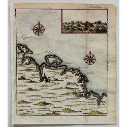
Cola (Untitled).
Uncommon map of part of the Kola peninsula coast, between the White and Barents Seas. It is in the Murmansk region.The town of Kola is shown but it is now eclipsed by the...
Date: Paris, 1725
Selling price: ????
Please login to see price!
Sold in 2017
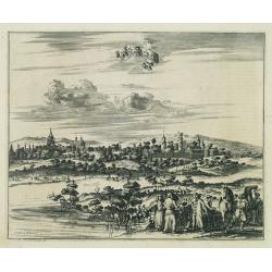
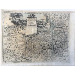
Cassimogorod ville de la Tartarie Moscovite.
Decorative view of the town of Cassimogorod, a Russian city near the northern shore of the Caspian sea as seen from across the river Occa. Finely etched view after a draw...
Date: Leiden, 1727
Selling price: ????
Please login to see price!
Sold in 2010
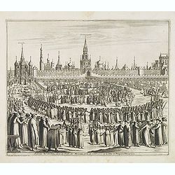
Château Kremelin, dans la ville de Moscou, avec la celebration de la Fete de Pâques Fleuries.
Decorative view of the Kremlin in Moscow, showing the Palm Sunday festivities at the Kremlin. Some buildings with captures: Kremlin, Porte du Sauveur. S. Nicolai. This we...
Date: Leiden, 1719-1727
Selling price: ????
Please login to see price!
Sold in 2013
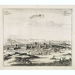
Astrakan, ville capitale du royaume du même nom en Moscovie.
Decorative view of the town of Astrakan. This well executed engraving was published in 1729 and 1727 by Pieter van der AA, in Leiden in "Voyages tres-curieux et tres...
Date: Leiden, 1719-1727
Selling price: ????
Please login to see price!
Sold in 2014
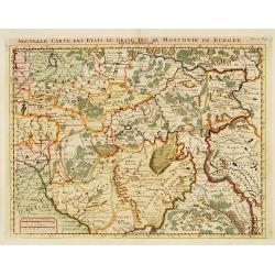
Nouvelle Carte des Etats..Moscovie en Europe.
Detailed map of central Russia. Moscow in the centre of the map. From Chatelain's Atlas Historique et Méthodique .
Date: Amsterdam 1728
Selling price: ????
Please login to see price!
Sold
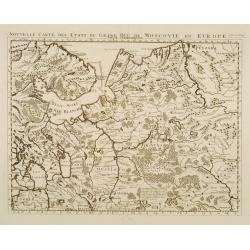
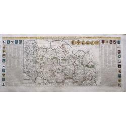
Nouvelle carte des etats du grand duc de Moscovie en Europe.
Northern part of European Russia.
Date: Amsterdam 1728
Selling price: ????
Please login to see price!
Sold
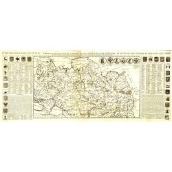
Carte générale des états du Czar Empereur de Moscovie, ou l'on voit ce que ce prince posséde en Europe et les états qu'il posséde en Asie.
General map of Russia of the states of the Czar Emperor of Muscovy showing his possessions in Europe and Asia. To the left and right explanatory panels with coats of arms...
Date: Amsterdam, 1728
Selling price: ????
Please login to see price!
Sold in 2011
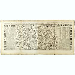
Carte du Gouvernement Civil et Ecclesiastique de Moscovie, l'Etat des Revenus et l'Ordre de la Justice et des Officiers
Very fine engraved text sheet with a small (5.5 x 5.5"), detailed plan of Moscow, plus two large coats-of-arms. Descriptive French text below, size is for the overal...
Date: Amsterdam, ca. 1728
Selling price: ????
Please login to see price!
Sold in 2010
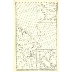
A Chart of the Sound -- A Map of the rivers Elbe and Weser -- The River Dvina and the harbour of Archangel.
Scarce sea chart by John Harris (1667?-1719) and James Knapton (d. 1738). Chart 20 from "Atlas maritimus & commercialis", showing Lapland and part of the Ru...
Date: London, J. Knapton, 1728
Selling price: ????
Please login to see price!
Sold in 2013
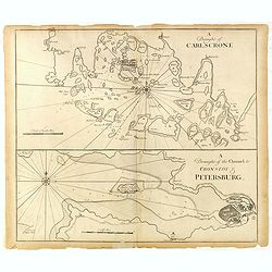
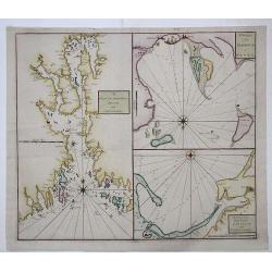
A Draught of Carlscone. A Draught of the Channel to Cronslot & Petersburg.
Two charts on one sheet: the upper chart is Karlskrona in Sweden, built as a base for the Royal Swedish Navy.The lower chart shows the approaches to St Petersburg, with K...
Date: London: J. & J. Knapton, W. & J. Innys, 1728
Selling price: ????
Please login to see price!
Sold in 2015
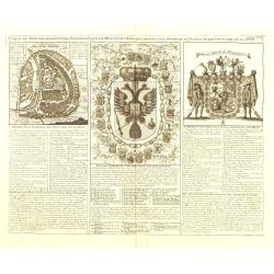
Carte Generale des Etats du Czar Empereur De Moscovie
A large and dramatic depiction of the Czars and their vast territories from 15th century to the early 18th century. Twenty-eight armorial shields, all color coded, are se...
Date: Amsterdam, ca 1728
Selling price: ????
Please login to see price!
Sold in 2015
DRAM and CHRISTIANIA / HARBOUR of REVEL / DANTZICK and KONINGSBERG
A scarce sea chart with three inset maps of Oslo (Christiania); Danzig and Kaliningrad (Konigsberg); and Tallin, Estonia.This very rare work was a collaborative effort of...
Date: London, 1728
Selling price: ????
Please login to see price!
Sold in 2017
Nouvelle carte des etats du grand duc de Moscovie en Europe.
Northern part of European Russia, Lithuania, Poland and the Ukraine with many references to Cossacks.Zacharie Chatelain (d.1723) was the father of Henri Abraham (1684-174...
Date: Amsterdam, 1728
Selling price: ????
Please login to see price!
Sold in 2017
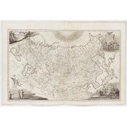
Generalis Totius Imperii Moscovitici Novissima Tabula. . .
A large map showing the whole of Russia; from the Black Sea and the Baltic to Kamchatka, China, and Northern India. Beautifully engraved and highly detailed, the map show...
Date: Neurenberg, 1728
Selling price: ????
Please login to see price!
Sold in 2018
Le Cours de la Riviere de Wolga Anciennement appellee RHA. Selon la Relation d'Olearius.
Map of the Volga River after Olearius' and published by Pieter van der Aa.Olearius's map of the lower Volga is the most important map 17th Century map of the River. Decor...
Date: Leiden, 1729
Selling price: ????
Please login to see price!
Sold in 2016
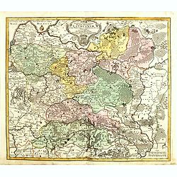
La Prusse. Suivant les Nouvelles Observations de Messrs. de l'Academie Royale des Sciences, etc. Augmentées de Nouveau. A Leide, chez Pierre vander Aa. - Avec Privilege.'
Decorative example of Van der Aa's map of Prussia, including Poland and Lithuania.
Date: Leiden, 1729
Selling price: ????
Please login to see price!
Sold in 2023
Reduction De La Carte De La Mer Caspienne..
Uncommon map of the Caspian Sea. Engraved by de Berey.
Date: Paris c.1730
Selling price: ????
Please login to see price!
Sold
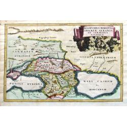
Geographica Nova ex Oriente gratiosissima, duabus tabulis specialissimis contenta, quarum una Mare Caspium..
Map of the Caspian Sea and the peninsula of Kamchatka (Jedso) in northeast Asia on one sheet.Separated by an attractive panel with figurative title cartouche, cherubs, an...
Date: Nuremberg 1730
Selling price: ????
Please login to see price!
Sold
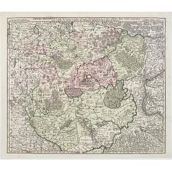
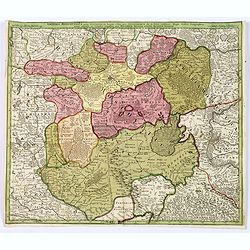
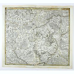
Imperii Moscovitici pars Australis..
Detailed map centered on Moscow.
Date: Augsburg 1730
Selling price: ????
Please login to see price!
Sold
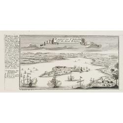
Prospect von S. Petersburg und der Insul Retufari.
Decorative view of Saint Petersburg, with a description and key to the left.
Date: Augsburg, 1730
Selling price: ????
Please login to see price!
Sold in 2008
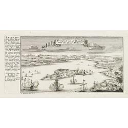
Prospect von S. Petersburg und der Insul Retufari.
Bird's-eye view of the island Retufari, with according to the key the town of Saint Petersburg (A) in background. With a description in German to the left.
Date: Augsburg, 1730
Selling price: ????
Please login to see price!
Sold in 2009
Reduction De La Carte De La Mer Caspienne. . .
Uncommon map of the Caspian Sea. Engraved by de Berey.
Date: Paris, c.1730
Selling price: ????
Please login to see price!
Sold in 2011
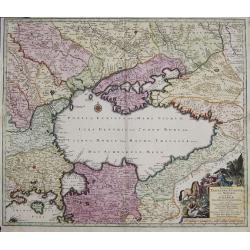
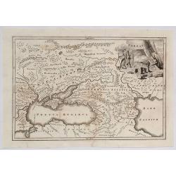
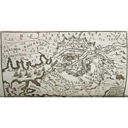
Nova Mappa Geographica Maris Assoviensis Vel De Zabache Et Paludis Maeotidis accurate aeri incis et in luce edita . . .
Striking map of the Sea of Azov with adjacent countries and the Strait of Kerch, with a decorative allegorical cartouche, showing the costumes of the indigenous people of...
Date: Augsburg, 1730
Selling price: ????
Please login to see price!
Sold in 2020
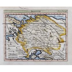
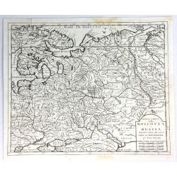
Moscovie.
Attractive small map of parts of Russia. Detailed map, includes Riga, Kiev, Moscow, Astrachan, Kazan, Perm, Smolensk, Crimea, many rivers, etc.
Date: ca. 1730
Selling price: ????
Please login to see price!
Sold in 2012
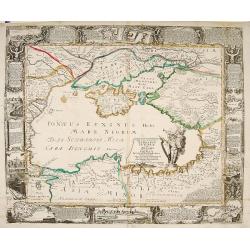
Nova et accurata Tartariae Europae seu minoris et in specie Crimeae delineatio geographica. . .
Map depicting the Black Sea with the peninsula Krim and its bordering countries, showing Asia Minor,Turkey, Bulgaria, Beesarabia, Armenia, Georgia and Ukraine etc.
Date: Augsburg, 1730
Selling price: ????
Please login to see price!
Sold in 2014
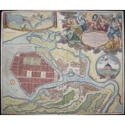
Topographische Vorstellung der Neuen Russischen Haupt-Residenz und See- Stadt St. Petersburg sammt ihrer zu erst aufgerichten Festung
Map shows a city map of St. Petersburg, a beautiful cartouche, a location map of St. Petersburg and Chronschloss. Homann was born in Oberkammlach near Kammlach in the Ele...
Date: Nuremberg, 1730
Selling price: ????
Please login to see price!
Sold in 2015
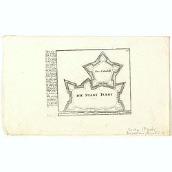
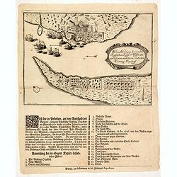
Die Stadt Terky. (Tarki)
Plan of Tarki, with a description and key to the left. Tarki is an urban locality under the administrative jurisdiction of Sovetsky City District of the City of Makhachka...
Date: Augsburg, 1730
Selling price: ????
Please login to see price!
Sold in 2015
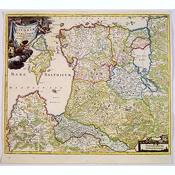
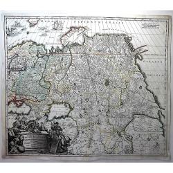
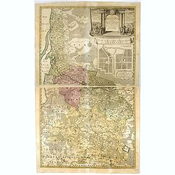
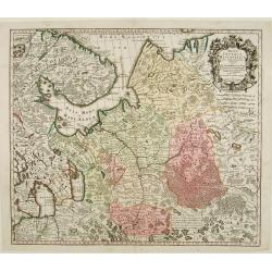
Ducatuum Livoniae et Curlandiae cum vicinis Insulis Nova Exhibitio Geographica. . .
A detailed map of the northern Baltic coast by Homann, pre-dating the privilege given to him. An attractive map covering Estonia and Latvia shows the fortified towns of G...
Date: Nüremberg, 1730
Selling price: ????
Please login to see price!
Sold in 2017
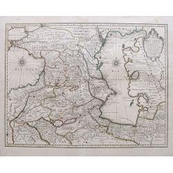
Carte des Pays Voisins de la Mer Caspiene. . .
An excellent map of the Caspian Sea, todays Georgia, Armenia and Azerbaijan. Includes also a part of the Black Sea, Turkmenistan, Iran, Russia, and Turkey. Highly detaile...
Date: Amsterdam, ca 1730
Selling price: ????
Please login to see price!
Sold in 2019
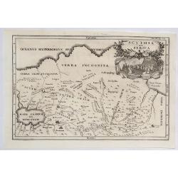
Scythia et Serica.
An interesting map of the region between the Caspian Sea and the Sea of China, much of which is 'Terra Incognita' in the North and East. Based upon 2000 year old geograph...
Date: Amsterdam, 1731
Selling price: ????
Please login to see price!
Sold in 2023
Sarmatda.
An interesting map of the Crimean Peninsula in Russia originally by Cellarius in 1731. It features a fine decorative cartouche with nomad peoples of the region. Christop...
Date: Venice, 1731
Selling price: ????
Please login to see price!
Sold in 2021
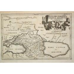
Bosporus, Maeotis, Iberia, Albania et Sarmatica Asiatica
Christoph Cellarius (1638-1707). Geographia Antiqua, 1686. A map of the Black Sea, the Caspium Sea and the area between. Embellished with a nice title-cartouche.
Date: Leipzig, Gledisch, 1732
Selling price: ????
Please login to see price!
Sold in 2009
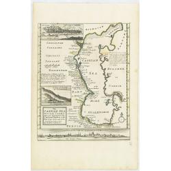
The Caspian Sea Drawn by the Czar's special command By Carl van Verden in the year 1719. 1720 and 1721. . .
Hand col. engraved map with 3 inset views. Includes geographical notes.With views of "Terky", "Derbent" and "Astracan"
Date: London, 1732
Selling price: ????
Please login to see price!
Sold in 2011
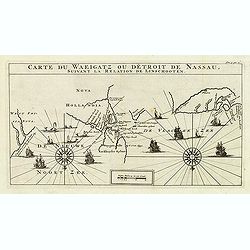
Carte Du Waeigatz ou Detroit De Nassau Suivant la Relation De Linschooten.
Decorative map of the Waeigatz Straits, between the southern part of Nova Zembla and the country of Samoyeds. Including two compass roses with radiating rhumb lines and v...
Date: Amsterdam, 1732
Selling price: ????
Please login to see price!
Sold in 2012
Carte générale des états du Czar Empereur de Moscovie ou l'on voit . . .
General map of Russia of the states of the Czar Emperor of Muscovy showing his possessions in Europe and Asia. To the left and right explanatory panels with coats of arms...
Date: Amsterdam, ca. 1732
Selling price: ????
Please login to see price!
Sold in 2017
Bosporus, Maeotis, Iberia, Albania, et Sarmatia Asiatica.
An historical map of the Black Sea and the Caspian Sea, including todays Crimea, Armenia, Georgia, Azerbaijan, parts of Turkey and Russia. With cities, rivers, mountains,...
Date: Leipzig, 1732
Selling price: ????
Please login to see price!
Sold in 2019
![[Recueil de Voyages au Nord].](/uploads/cache/48310-250x250.jpg)
[Recueil de Voyages au Nord].
Extract from volume III of the "Recueil de Voyages au Nord", containing the reports of Linschoten's voyages, the first to the North through the Strait of Nassau...
Date: Amsterdam, Bernard, 1732
Selling price: ????
Please login to see price!
Sold in 2022
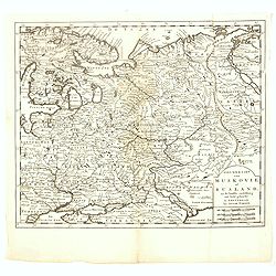
Nieuwe Kaart van Muskovie of Rusland.
Detailed map of European Russia, far south to the Black Sea and Caspian Sea. Isaac Tirion was born in Utrecht ca. 1705. He came to Amsterdam ca. 1725. Tirion published a ...
Date: Amsterdam, 1734
Selling price: ????
Please login to see price!
Sold in 2017
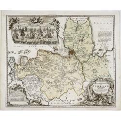
Ingermanlandiae seu Ingriae novissima tabula luci tradita. . .
A detailed map with an imposing title cartouche and a panoramic view of St Petersburg. The region, known as Ingria, was annexed by Peter the Great in 1721 at the conclusi...
Date: Nurenberg, 1734
Selling price: ????
Please login to see price!
Sold in 2021
Imperii Russici tabula generalis quo ad fieri potuit / accuratissime descripta opera et studio Ioannis Kyrilow, …
General 1734 large-format map of the Russian Empire compiled by Ivan Kirilov (1689/1695]-1737), the Chief Secretary of the Governing Senate in St. Petersburg in 1734. ...
Date: Saint Petersburg : [Academy of Sciences], 1734
Selling price: ????
Please login to see price!
Sold in 2025
Afbeelding der Battalje .. Moscoviters en de Turken ..
An attractive birds-eye-view from the battle between Russians and Turkish, published in the rare first edition of "Kleyne en Beknopte Atlas, of Tooneel des Oorlogs i...
Date: Amsterdam 1735
Selling price: ????
Please login to see price!
Sold
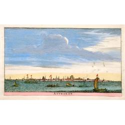
Astrakan.
An attractive panoramic view of Astrakan in Russia. Published in the rare first edition of Kleyne en Beknopte Atlas, of Tooneel des Oorlogs in Europa..The atlas was publ...
Date: Amsterdam 1735
Selling price: ????
Please login to see price!
Sold

Nova Maris Caspii et Regions Usbeck..
A detailed map of part of Russia, Central Asia centered on the Caspian, Uzbek territory to the east of the Caspian and northern Persia. A finely engraved, uncolored title...
Date: Nuremberg, 1735
Selling price: ????
Please login to see price!
Sold in 2024
Nova Maris Caspii et Regions Usbeck..
A detailed map of Central Asia centered on the Caspian Uzbek territory to the east of the Caspian and northern Persia. A finely engraved, uncolored title piece showing co...
Date: Nuremberg, 1735
Selling price: ????
Please login to see price!
Sold in 2010
Nieuwe kaart van de Crim de Zwarte Zee en omleggende. . .
Showing the Black Sea and the Marmara Sea with Istanbul. Published in the rare first edition of Kleyne en Beknopte Atlas, of Tooneel des Oorlogs in Europa...The atlas wa...
Date: Amsterdam, 1735
Selling price: ????
Please login to see price!
Sold in 2013
Potentissimo Borussorum Regi Friderico Wilhelmo...
Large 2-sheet map of an area of Lithuania and Eastern Prussia (Russian province of Kaliningrad) stretching from Klaipeda (Memel) in the north to Goldap in the south (a to...
Date: Nuremberg, 1735
Selling price: ????
Please login to see price!
Sold in 2011
Potentissimo Borussorum Regi Friderico Wilhelmo...
Large sought-after 2-sheet map of an area of Lithuania and Eastern Prussia (Russian province of Kaliningrad) stretching from Klaipeda (Memel) in the north to Goldap in th...
Date: Nuremberg, 1735
Selling price: ????
Please login to see price!
Sold in 2012
Potentissimo Borussorum Regi Friderico Wilhelmo. . .
Large sought-after 2-sheet map of an area of Lithuania and Eastern Prussia (Russian province of Kaliningrad) stretching from Klaipeda (Memel) in the north to Goldap in th...
Date: Nuremberg, 1735
Selling price: ????
Please login to see price!
Sold in 2015
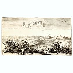
Ontzet van de Stad Nerva door zyne Koninglyke Majesteit van Sweden, voorgevallen op den 30sten November 1700.
An attractive etching showing a battle scene before the city of Nerva during the relief of the City by the King of Sweden on 30 November 1700.Engraved by Gasper Luyken.Fi...
Date: Amsterdam, 1735
Selling price: ????
Please login to see price!
Sold in 2014
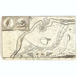
Beleg van Nerva door de Muskoviters.
An attractive engraving showing the battle plan of the city of Nerva during the siege by the Peter the Great. With two engraved medallions in left upper corner.First publ...
Date: Amsterdam, 1735
Selling price: ????
Please login to see price!
Sold in 2014
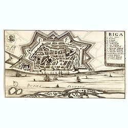
Beleg van Nerva door de Muskoviters.
An attractive engraving showing Riga, the capital of Latvia. In the foreground the River Daugava. Riga is the largest city in the Baltic states. First published by Erven ...
Date: Amsterdam, 1735
Selling price: ????
Please login to see price!
Sold in 2014
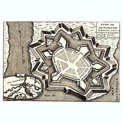
Fort de Dunamund en Livonie, située a 48 degrez de longitude. . .
An detailed engraving of a fortress of Daugavgriva (Dunamunde, Dynemunt) in Latvia with an inset map of Riga with its surroundings.First published by DeLa Feuille, than p...
Date: Amsterdam, 1735
Selling price: ????
Please login to see price!
Sold in 2014
Novissima et accuratissima Magni Ducatus Lithuaniae in suos Palatinaus et Castellanias divisae Delineatio . . .
Uncommon third edition of Seutter's map of Lithuania, extending from Riga to Palatinat Polesia Bressicenis in the south.This is the third edition with the JM Probst impri...
Date: Augsburg, 1735
Selling price: ????
Please login to see price!
Sold in 2017
Potentissimo Borussorum Regi Friderico Wilhelmo Maiestate, Fortitudine Clementia Augustissimo Hancce Lithuaniam Borussicam : in qua luca coloniis Salisburg., ad incolendum Regio nutu concessa chorographice exhibentur D. D. D. Regiae Suae Maiestatis.
Large 2-sheet map of an area of Lithuania and Eastern Prussia (Russian province of Kaliningrad) stretching from Klaipeda (Memel) in the north to Goldap in the south (a to...
Date: Nuremberg, 1735
Selling price: ????
Please login to see price!
Sold in 2016
Neu- eröffnetes Welt- und Staats- Theatrum... (WITH 2 RARE MAPS OF AZOV)
Scarce book containing two rare maps of the city of Azov on the Don River. Further illustrated by 18 engraved portraits and views! With nicely drawn portraits of Kings a...
Date: Erfurt, 1736
Selling price: ????
Please login to see price!
Sold in 2012
Imperii Moscovitici pars Australis. . .
A detailed map of the southern part of the Russian Empire, after De L'Isle. It extends from Moscow south to the Ukraine and east to Astrakan. It is a detailed map centere...
Date: Augsburg, ca. 1736
Selling price: ????
Please login to see price!
Sold in 2018
Imperii Moscovitici pars Australis. . .
A detailed map of the southern part of the Russian Empire, after De L'Isle. It extends from Moscow south to the Ukraine and east to Astrakan. It is a detailed map centere...
Date: Augsburg, ca. 1736
Selling price: ????
Please login to see price!
Sold in 2020
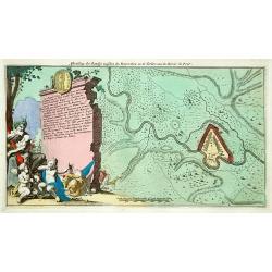
Charte der Kriegs Operationen am Donn und Dnieper. Ihro Russisch Key Serl: Maiesty: gloriousen Armeen A 1736. . .
Very rare map of the southern part of Ukraine, with an explanatory key A-N in lower right. One of five maps (see also Atlas Ukrainae et Ponti Euxini, 41 - 44) published b...
Date: St. Petersburg, c. 1736-1737
Selling price: ????
Please login to see price!
Sold in 2011
Wahre abbildung der von den Russischen keijserl: Waffen am 13 Jul: 1737 mit Sturm eroberten Vestung Oczakoff.
Rare broadsheet with an expertly engraved plan (210 x 290mm.) of the Russian siege of Oczaków at 13 July 1737. Turkish vessels in the Black Sea leaving the town.In lower...
Date: Leipzig, 1737
Selling price: ????
Please login to see price!
Sold in 2014
Nuova Carta della Moscovia o Russia.
A finely engraved map of European Russia with details of cities, towns, forests and topography, by Albrizzi, after Isaak Tirion (1705–1765) who was an 18th-century publ...
Date: Venice, 1738
Selling price: ????
Please login to see price!
Sold in 2018
Imperii Russici et Tatariae Universae.
Finely engraved map of Greater Russia, from the Baltic, across Siberia to Kamchatka, with Japan, Korea, and the Greater portion of China. Very elaborate cartouche with be...
Date: Nuremberg, 1739
Selling price: ????
Please login to see price!
Sold in 2013
Tartariae Maioris sive Asiaticae Tabula..
This antique map shows the "Russian Tartary" and as well the "Asian Tartary".With title cartouche in the lower left corner, another title cartouche wi...
Date: Nuremberg, 1739
Selling price: ????
Please login to see price!
Sold
Imperii Russici et Tatariae Universae tam majoris et Asiaticae quam minoris et Europaeae Tabula.
Finely engraved and very detailed map of the Russian Empire covering the region from the Baltic Sea across Siberia up to Japan. The a decorative cartouche contains hunter...
Date: Nuremberg, 1739
Selling price: ????
Please login to see price!
Sold in 2010
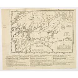
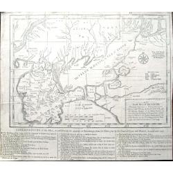
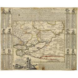
An exact map of the CRIM (Formely Taurica Chersonesus) Part of Lesser Tartary, the Sea of Asoph, and the adjacent Country of the Kuban Tartars. . .
Detailed and handsome wood block printed map centered on the Sea of Azov detailing the ongoing war between the Russians and Turks. The map is filled troop locations and b...
Date: London, 1739
Selling price: ????
Please login to see price!
Sold in 2010
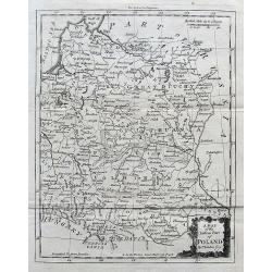
A Map of the Eastern Part of Poland.
A seldom-seen small map of parts of today's Poland, Lithuania, Latvia, Belarus, and Ukraine.
Date: London, ca. 1739
Selling price: ????
Please login to see price!
Sold in 2017
An Exact Map of the Crimea. . .
A fascinating map of the Crimea, the Sea of Azov and Lesser Tartary, illustrating the Russian and Turkish conflict in the region. The map is filled with troop locations a...
Date: London, 1739
Selling price: ????
Please login to see price!
Sold in 2019
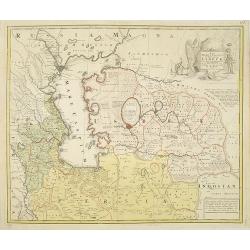
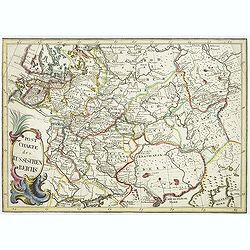
Mappae Imperii Moscovitici pars Septentrionalis..
Detailed map of northern Russia embellished with an uncolored pictorial cartouche showing hunting scenes.Prepared by de l'Isle.
Date: Augsburg 1740
Selling price: ????
Please login to see price!
Sold
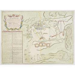
Plan der Bataille bey Stovutschane in der Moldau ..
Rare plan of a siege between the Russian army and the German and Turkish armies. Texts in German and Russian.
Date: Germany 1740
Selling price: ????
Please login to see price!
Sold
Nova et accurata Tartariae Europae.. Crimeae..
Very rare carte-a-figure map of the Black Sea area. With decorative title cartouche and surrounded by four borders with 10 city views each accompanied by large descriptiv...
Date: Augsburg 1740
Selling price: ????
Please login to see price!
Sold
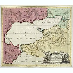
Tartaria Minor. . . . Calendarium Perpetuum oder Ein Immerwährender Kalender. . .
Very rare map of the Crimea and Ukraine, surrounded by a Calendarium Perpetuum. Each month is represented in a block with the the days and its Saint and topped with a dwa...
Date: Augsburg, 1740
Selling price: ????
Please login to see price!
Sold in 2025
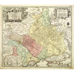
Amplissima Ucraniae Regio Palatinatus Kioviensem et Braclaviensem . . .
An uncommon and attractive map of the Ukraine has excellent detail of the river systems and charming, pictorial topography. It is decorated with two elegantly engraved ca...
Date: Augsburg, 1740
Selling price: ????
Please login to see price!
Sold in 2011
Post Charte des Russischen Reichs.
Rare map of Russia showing the postal roads. Large title cartouche in lower left corner.More about post road mapspost route maps.
Date: Germany, ca. 1740
Selling price: ????
Please login to see price!
Sold in 2010
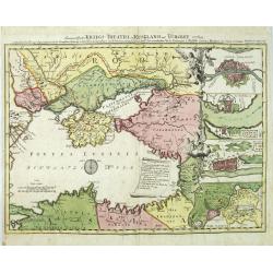
Des neueroffneten Kriegs-Theatri in Rusland und Turckey..
A rare map of the Black Sea, the scene of Russia-Turkish hostilities in 1736-9. The inset fortification plans feature Constantinople, Azov, Bendery and the strongholds at...
Date: Nuremberg 1740
Selling price: ????
Please login to see price!
Sold in 2010
