Browse Listings in Europe > Russia / Baltic / Black Sea region
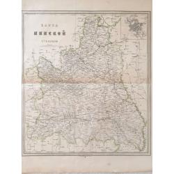
![Karta Kievskoi Gubernii [Kiev Governorate, Ukraine].](/uploads/cache/34757-250x250.jpg)
Karta Kievskoi Gubernii [Kiev Governorate, Ukraine].
A detailed map of Ukraine's Kyiv Governorate, printed in St. Petersburg by Alexey Afinogenovich Ilyin, one of the most important 19th Century maps of the region.This fine...
Date: St. Petersburg, 1871
Selling price: ????
Please login to see price!
Sold in 2021
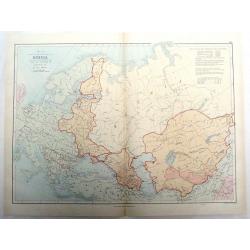
![[Tittle in Russian] Kapta. . . (Map of the Russian North Coast).](/uploads/cache/29142-250x250.jpg)
[Tittle in Russian] Kapta. . . (Map of the Russian North Coast).
A detailed wall map sized map of the Northern coast of Russia with a color key in top which seems to highlight the various Russian Artic explorations along the coast usin...
Date: Moscow, 1872
Selling price: ????
Please login to see price!
Sold in 2014
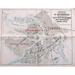
Sketch Map of the Districts of St. Petersburg to be supplied by the City of St. Petersburg New Waterworks Company Limited.
A scarce plan of St. Petersburg. The names of the districts to be "newly" supplied with water - "Vieux Petersburg" (Peterburgskaya), "Viborgskaya...
Date: St. Petersburg, 1873
Selling price: ????
Please login to see price!
Sold in 2017
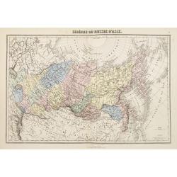
Sibérie ou Russie d'Asie.
Decorative map of Russia from Géographie Universelle, Atlas Migeon. published by J. Migeon. From one of the last decorative atlases published in the 19th centu...
Date: Paris, 1874
Selling price: ????
Please login to see price!
Sold in 2009
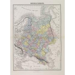
Russie d'Europe.
A decorative map of Russia from Géographie Universelle, Atlas Migeon, published by J. Migeon.From one of the last decorative atlases published in the 19th century.
Date: Paris, 1874
Selling price: ????
Please login to see price!
Sold in 2014
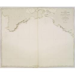
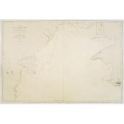
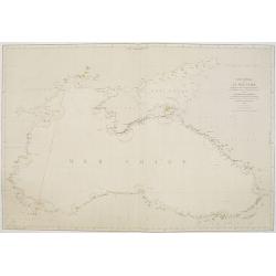
Carte de la Mer Noire. (3e Feuille). Du Cap Chersonèse à la pointe Chardak.
Very detailed chart of the Black Sea with the entry to the Sea of Azof. including the towns of Kerch, Sevastopol, etc. Showing soundings in meters, lighthouses are marked...
Date: Paris, 1860 updated to 1874
Selling price: ????
Please login to see price!
Sold in 2012
Carte de la Mer Noire. (2e Feuille). De Mangalia au Cap Chersonèse.
Very detailed chart of the Black Sea including the towns of Odessa, Sevastopol, etc. In the upper right corner small inset map of the Dniprov River up to Nikolaef. Showin...
Date: Paris, 1860 updated for 1874
Selling price: ????
Please login to see price!
Sold in 2012
![[Tittle in Russian] Kapta...(Taymyr Peninsula)](/uploads/cache/29138-250x250.jpg)
[Tittle in Russian] Kapta...(Taymyr Peninsula)
Chart of the Russian peninsula of Taymyr in Northern Russia. Lithograph, in two sheets joined as one. This map in great detail appears to be a Russian government chart. I...
Date: Moscow, 1874
Selling price: ????
Please login to see price!
Sold in 2014
Plan général des environs de Sébastopol avec indication de la disposition générale de l'armée alliée au 24 octobre / 5 novembre 1854 et du mouvement du prince Gortchakow vers le mont Sapoune.
A very rare panoramic town-plan of the siege of Sebastopol. In lower margin : "Gravé au Dépôt topographique de la Guerre". From "Défense de Sébastopol...
Date: Saint-Pétersbourg / Paris, 1863-1874
Selling price: ????
Please login to see price!
Sold in 2014
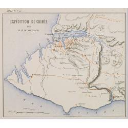
Expédition de Crimée. 1854 Plan de Sébastopol.
Map of Krim area centered on Sebastopol and showing in red the French expedition of 1854. Published in \"Atlas de Géographie Militaire adopté par M. le min. de la ...
Date: Paris, Furne, Jouvet et Cie, 1875
Selling price: ????
Please login to see price!
Sold in 2009
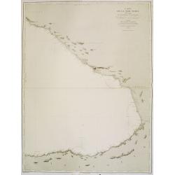
Carte de la Mer Noire. (4e Feuille). Du Cap Idokopas au Cap Zefiros.
Very detailed chart of the eastern part of the Black Sea with the coast of Georgia, including the towns of Lidzava, Anaklia, Poti, Supsa, Kobuleti. Showing soundings in m...
Date: Paris, 1860 updated to 1875
Selling price: ????
Please login to see price!
Sold in 2013
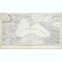
Carte générale de la Mer Noire Dressée d'après les travaux russes . . .
Chart of the Black Sea, with latitude and longitude scales, villages, banks and soundings in fathoms. Lighthouses highlighted in yellow and red.A line in red pen and ink ...
Date: Paris, 1860 with updates for 1868 - 1876
Selling price: ????
Please login to see price!
Sold in 2011
Schwarzes Meer Nr 1
Uncommon map of the Black Sea and Crimea. In lower part a scale. Prepared by F.Handtke
Date: Glogau, Leipzig, 1877
Selling price: ????
Please login to see price!
Sold in 2011
![Die Ethnographie Russland's. [With two maps]](/uploads/cache/32955-250x250.jpg)
Die Ethnographie Russland's. [With two maps]
A 43 pages ethnographical description of Russia by A. F. Rittich. Including chapters on : Die Kaukasus-Völker - Hyperboreer oder Arktiker - Die Völker der Mongolischen ...
Date: Gotha, Perthes, 1878
Selling price: ????
Please login to see price!
Sold in 2012

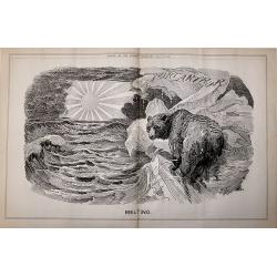
A set of 16 humorous prints of Russian interest and The Russian Empire's Crimea war with the French and British Empire's.
This set of 16 are from 1853 - 1878. Mostly engraved by Joseph Swain. Joseph Swain was one of the most important woodblock engravers. Punch was responsible for the word s...
Date: London 1853 – 1878
Selling price: ????
Please login to see price!
Sold in 2016

A set of 20 humorous prints of Russian interest and The Russian Empire's Crimea war with the French and British Empire's 1853 - 1878
This set of 20 are from 1853 - 1878. Mostly engraved by Joseph Swain. Joseph Swain was one of the most important woodblock engravers. Punch was responsible for the word s...
Date: London, 1853 - 1878
Selling price: ????
Please login to see price!
Sold in 2016
A set of 20 humorous prints from the Russian Empire's war with the French and British Empire's.
This set of 20 are dated from 1853 - 1878. Mostly engraved by Joseph Swain. Joseph Swain was one of the most important woodblock engravers. Punch was responsible for the ...
Date: London 1853 - 1878
Selling price: ????
Please login to see price!
Sold in 2016
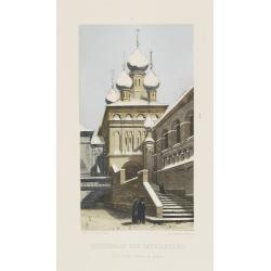
Cathédrale des Patriarches, (Saints Apôtres) intérieur du Kremlin.
Beautiful lithography of the Cathédrale des Patriarches in Kremlin, Moscow.
Date: Paris, ca. 1880
Selling price: ????
Please login to see price!
Sold in 2009
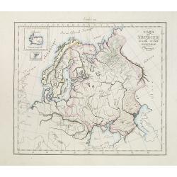
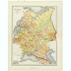
Nord de l'Europe Russie Suède -Denemach- Physique. Etude 19.
Map of the North of Europe including Russia, Sweden and Denmark with two inset maps of Island and the Danish Faeroe Islands.
Date: Paris, c. 1880
Selling price: ????
Please login to see price!
Sold in 2010
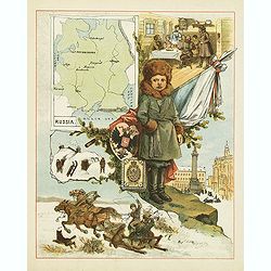
(Russia)
This color lithography carries in the upper left corner a map of European Russia with several towns mentioned. In the center a child and further decorated with flag, coat...
Date: c. 1880
Selling price: ????
Please login to see price!
Sold in 2012
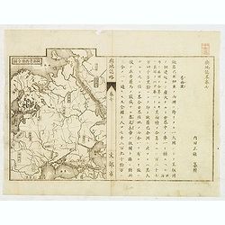
Japanese map of Central part of Europe with Black Sea and Ukraine.
Japanese map of Central part of Europe with Black Sea and Ukraine, with a description to the right.
Date: Japan, ca. 1880
Selling price: ????
Please login to see price!
Sold in 2012
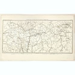
Carte de la Route de Wilna à Moscou.
Detailed road map of the European part of Russia, centered on Minsk, Smolensk and Moscow in the upper right corner, prepared by A. H. Basset, rue Saint-Jacques, no. 55, P...
Date: Paris, 1880
Selling price: ????
Please login to see price!
Sold in 2023
Russia in Europe with Transcaucasia.
Charming late map of Russia.
Date: London, 1880
Selling price: ????
Please login to see price!
Sold in 2018
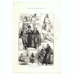
Sketches in Russia: Popular life and manners.
Six images on one plate of Russian in typical costumes published in "The Illustrated London News" of 1880.
Date: London, 1880
Selling price: ????
Please login to see price!
Sold in 2016
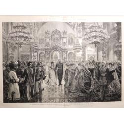
The Imperial Coronation at Moscow.... 19 woodblock engravings
A collection of 19 woodblock engravings from "The Illustrated London News" mostly dated June 1883. The engravings display all phases of the Imperial Coronation ...
Date: London, 1883
Selling price: ????
Please login to see price!
Sold in 2016

A set of 16 humorous prints of Russian interest and The Russian Empire's war with the French and British Empire's.
This set of 16 are from 1853 - 1885. Mostly engraved by Joseph Swain. Joseph Swain was one of the most important woodblock engravers.Punch was responsible for the word se...
Date: London 1853 - 1885
Selling price: ????
Please login to see price!
Sold in 2016
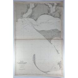
Mer Noire - Entrée du Liman du Dnieper et Baie de Tendra.
A fine large sea chart on the Black Sea in the Ukraine featuring the Dnieper River and the Tendra Bay. It has an insert of Liman de Berezan and shows Kinburn Spit and Ca...
Date: Paris, 1887
Selling price: ????
Please login to see price!
Sold in 2018

A set of 20 humorous prints of Russian interest and The Crimea, The Russian Empire's war with the French and British Empire's. 1849 - 1888 London 1849 - 1888
This set of 20 are from 1849 - 1888. Mostly engraved by Joseph Swain. Joseph Swain was one of the most important woodblock engravers. Punch was responsible for the word s...
Date: London, 1849 - 1888
Selling price: ????
Please login to see price!
Sold in 2016
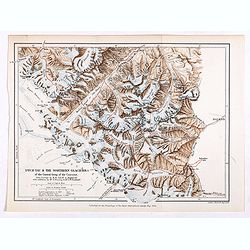
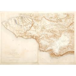
Dych-Tau & the Northern Glaciers of the Central Group of the Caucasus from surveys by M.M.Jukoff & Bogdanoff. . .
Early map of Dykh-Tau or Dykhtau, from surveys by M.M.Jukoff & Bogdanoff. Dykh-Tau is a mountain located in Kabardino-Balkaria, Russia, its peak stands about 5 km (3 ...
Date: London, Edward Stanford, 1890
Selling price: ????
Please login to see price!
Sold in 2019
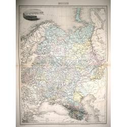
Russie.
Full inscriptions: Russie. Grave par L. Smith. Dresse Sous La Direction De J. Migeon Par Ch. Lacoste. Migeon, editeur, imp, r. du Moulin Vert, Paris. Ecrit par A. Bizet. ...
Date: Paris, 1892
Selling price: ????
Please login to see price!
Sold in 2014
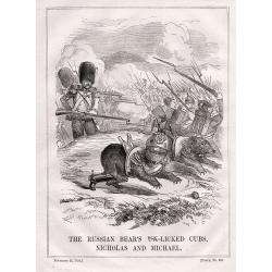
A set of 23 humorous Punch prints of Russian interest and The Crimea, The Russian Empire's war with the French and British Empire's. 1853 - 1894
This set of 23 prints are from 1853 - 1894. Mostly engraved by Joseph Swain. Joseph Swain was one of the most important woodblock engravers. Punch was responsible for the...
Date: London, 1853 – 1894
Selling price: ????
Please login to see price!
Sold in 2016
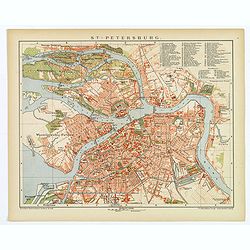
St. Petersburg.
A lovely detailed double page plan of the famous Russian city of St. Petersburg. From 'Brockhaus' Konversations-Lexikon', published by F. A. Brockhaus, in Leipzig. A num...
Date: Leipzig, 1895
Selling price: ????
Please login to see price!
Sold in 2018
Map of Minsk gubernia.
Карта Минской губ&am...
Date: Sankt Peterburg, 1850-1900
Selling price: ????
Please login to see price!
Sold in 2018
A Sketch of the Acquisition of Russia in Europe and Central Asia Since the Accession of Peter 1st to the Throne.
Large chromo-lithograph map of Russia with portions of surrounding countries featuring the areas of land that Russia acquired from them. Interesting historical facts are ...
Date: London, 1901
Selling price: ????
Please login to see price!
Sold in 2015
![[Russia]](/uploads/cache/25601-250x250.jpg)
[Russia]
A more than 100 year old map of the world of Russia printed in lithography. Published by one of the most successful publishers of St. Petersburg A.Iljin. With a color key...
Date: St. Petersburg, c.1905
Selling price: ????
Please login to see price!
Sold in 2010
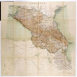
Caucasia.
Original hand-colored zincograph map of the Caucasus located at the border of Europe and Asia. The map shows part of the Black Sea and the Caspian Sea. The map is on a sc...
Date: London, 1906
Selling price: ????
Please login to see price!
Sold in 2017
A set 15 of Punch cartoons from the periods of the Russo - Japanese War of 1904 - 5 and the crisis facing the Czar.
A set 15 of Punch cartoons from the periods of the Russo – Japanese War of 1904 – 5 and the crisis facing the Czar. The titles:Melting June 15th 1904 (double Page).Ti...
Date: London, 1903-1907
Selling price: ????
Please login to see price!
Sold in 2017
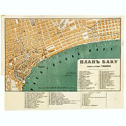
Baku (Баку, Bakı) city map, 1912
color lithographed plan of Baku (Baki) in Azerbaijan by A.Yakovenko, a publisher active in in Saint Petersburg. Scales in Russian sazhens and British inches and two numbe...
Date: Saint Petersburg, 1912
Selling price: ????
Please login to see price!
Sold in 2017
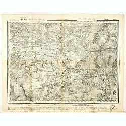
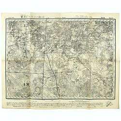
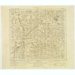
Government Minsk. - Russland 1:126,000 V. XVII.6.
Folding military topographic map of part of Belarus, issued by the General Staff of the German Army. Scale 1:126000 (3 km (Werst) in 1 inch). Centered on Sluzk.Along uppe...
Date: Germany, 1915
Selling price: ????
Please login to see price!
Sold in 2021
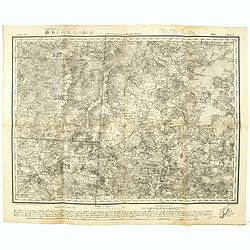
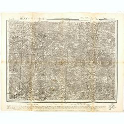
Government Minsk u. Wilna Mirr Blatt 5. - Russland 1:126,000 V. XVI.5.
Folding military topographic map of part of Belarus, issued by the General Staff of the German Army. Scale 1:126000 (3 km (Werst) in 1 inch). Centered on Mir.Along upper ...
Date: Germany, 1915
Selling price: ????
Please login to see price!
Sold in 2021
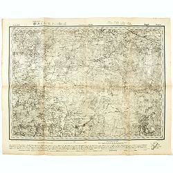
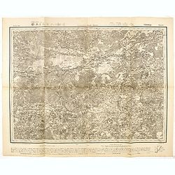
Government Minsk. Kopyl Blatt 6. - Russland 1:126,000 V. XVI.6.
Folding military topographic map of part of Belarus, issued by the General Staff of the German Army. Scale 1:126000 (3 km (Werst) in 1 inch). Centered on Schazk.Along upp...
Date: Germany, 1915
Selling price: ????
Please login to see price!
Sold in 2021
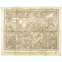
Government Minsk. Klezk Blatt 5. - Russland 1:126,000 V. XVII.5.
Folding military topographic map of part of Belarus, issued by the General Staff of the German Army. Scale 1:126000 (3 km (Werst) in 1 inch). Centered on Sinjawka.Along u...
Date: Germany, 1915
Selling price: ????
Please login to see price!
Sold in 2021
Government Wilna u. Kowno Widsy Blatt 5. - Russland 1:126,000 V. XII.5.
Folding military topographic map of part of Belarus, issued by the General Staff of the German Army. Scale 1:126000 (3 km (Werst) in 1 inch). Centered on Swenzjany.Along ...
Date: Germany, 1915
Selling price: ????
Please login to see price!
Sold in 2016
Government Minsk u Kowno. Glubokoje Blatt 6.- Russland 1:126,000 V. XII.6.
Folding military topographic map of part of Belarus, issued by the General Staff of the German Army. Scale 1:126000 (3 km (Werst) in 1 inch). Centered on Glubokoje.Along ...
Date: Germany, 1915
Selling price: ????
Please login to see price!
Sold in 2016
GovernmentWilna u. Minsk. Dokschitzy Blatt 6.- Russland 1:126,000 V. XIII.6.
Folding military topographic map of part of Belarus, issued by the General Staff of the German Army. Scale 1:126000 (3 km (Werst) in 1 inch). Centered on Budslaw.Along up...
Date: Germany, 1915
Selling price: ????
Please login to see price!
Sold in 2016
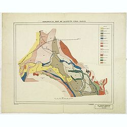
Geological map of the Donetz coal basin.
Uncommon American geological map of the Russian Donetz coal zone, published by R. Martens & Co. From New York. color key in lower left corner. The coal-field was disc...
Date: New-York, ca. 1916
Selling price: ????
Please login to see price!
Sold in 2013
Geological map of Kuznetz coal basin.
American geological map of the Russian Kuznetsk Coal zone, published by R. Martens & Co. From New York. color key in upper The development of the coal fields of Kuzne...
Date: New-York, ca. 1916
Selling price: ????
Please login to see price!
Sold in 2012
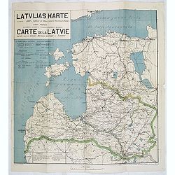
Latvijas Karte. . . Carte de la Latvie editée par le conseil national Latvien en Siberie.
One of the earliest maps showing an independent Latvia, in 1919. Estonia in upper right corner. Prepared by Luit. MantnieksOn July 21, 1919, Latvia and Estonia signed a b...
Date: Latvia, 1919
Selling price: ????
Please login to see price!
Sold in 2017
(Military map as paper for stamps of the newly formed Latvia.) No. P. 17 Birze)
The first stamps of Latvia – printed on German military maps almost 100 years ago. Military map with red 5. Kap stamps - the rarer perforated and gummed version, showin...
Date: Riga, Schnaekenburg printing, 1918-1919
Selling price: ????
Please login to see price!
Sold in 2012
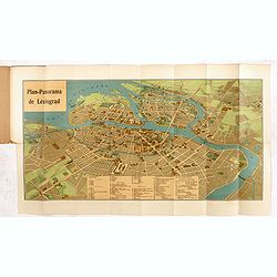
Plan-Panorama de Léningrad.
Official Intourist booklet with a panoramic plan of St. Petersburg printed in chromo-lithography, folded and kept in beige wrapper with title "PLAN-PANORAMA DE LENIN...
Date: Russia, 1931-1934
Selling price: ????
Please login to see price!
Sold in 2014
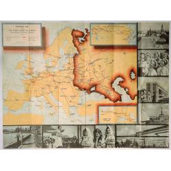
Intourist Map of the Soviet Union and Europe Showing Principal Transportation Connections.
An interesting map - especially as it was published just before WWII. Date is based on "Intourist suggested itineraries for 1939". Soviet Union borders shown in...
Date: New York, 1939
Selling price: ????
Please login to see price!
Sold in 2019
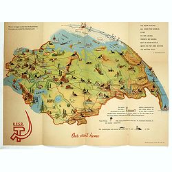
Our vast home.
Propaganda folder with pictorial map of Russia, published for Brussels Universal and international exhibition, 1958. This World exhibition was held April 17 through Octob...
Date: U.S.S.R., 1958
Selling price: ????
Please login to see price!
Sold in 2017
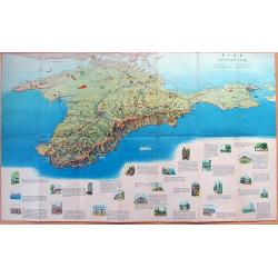
MAP OF CRIMEA
Large illustrated tourist-map of Crimea, with a beautiful representation of the topographic features of the peninsula. Published by the Office of Geodesy and Cartography ...
Date: Moscow, 1963
Selling price: ????
Please login to see price!
Sold in 2012
![[Travel in Five Soviet Republics by Car].](/uploads/cache/44797-250x250.jpg)
[Travel in Five Soviet Republics by Car].
A nicely presented Russian route planner from Moscow in the Soviet Union to (Talin) Estonia, (Riga) Latvia, (Vilnius) Lithuania and (Minsk) Belarus. Inside front cover ha...
Date: Moscow, 1963
Selling price: ????
Please login to see price!
Sold in 2019
![[RUSSIAN MAP] Battle of Stavuchany 1739.](/uploads/cache/85306-250x250.jpg)
[RUSSIAN MAP] Battle of Stavuchany 1739.
An extremely rare, large Russian single sheet map, of the plan of the battle of Stavuchany. Printed in Russian and German languages, possibly by the Academy of St.Petersb...
Date: St.Petersburg, ca 1739
Selling price: ????
Please login to see price!
Sold in 2021
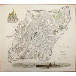
Moscow MOCKBƃI W. B. Clarke for S.D.U.K.- General Atlas...of The Society for the Diffusion of Useful Knowledge.
Very attractive engraved plan of the city centered on the Kremlin. All major streets, many public places, and buildings named. Details shown on many of the fortified area...
Date: London, 1836
Selling price: ????
Please login to see price!
Sold in 2013

A set of 20 humorous prints from the Russian Empire's war with the French and British Empire's and beyond
This set of 20 are dated between 1855-1894. Mostly engraved by Joseph Swain. Joseph Swain was one of the most important woodblock engravers. Punch was responsible for the...
Date: London, 1855 - 1894
Selling price: ????
Please login to see price!
Sold in 2016
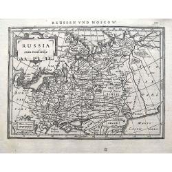
Russia cum Confiniis.
An early map of western Russia from the "Atlas Minor" (Gerhard Mercator / Jodocus Hondius). Extends from Lappland until the Caspian Sea. With two small cartouch...
Date: Amsterdam, 1609 or later
Selling price: ????
Please login to see price!
Sold in 2018
