Browse Listings in Europe > Russia / Baltic / Black Sea region
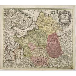
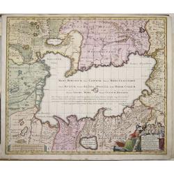
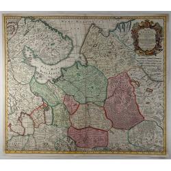
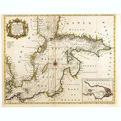
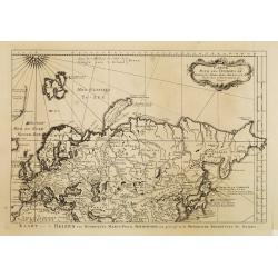
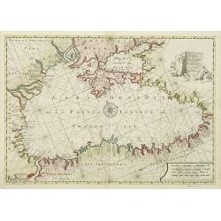
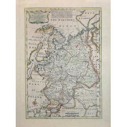
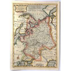
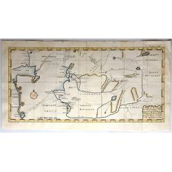
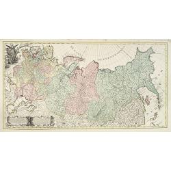
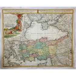
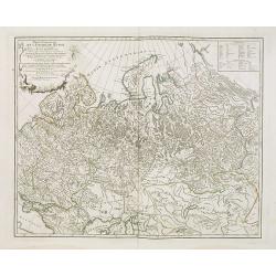
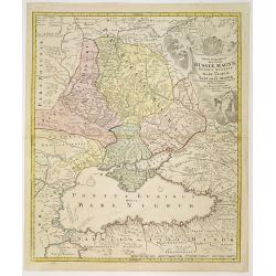
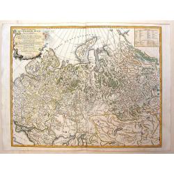
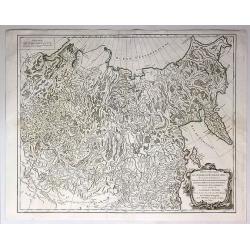
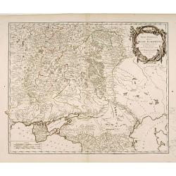
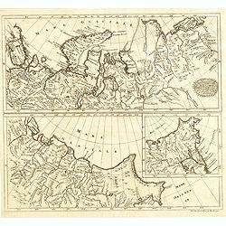
Mappae Imperii Moscovitici pars Septentrionalis.
Detailed map of northern Russia embellished with an uncolored pictorial cartouche showing hunting scenes.Good detail in Lapland, the White Sea and Archangel. St. Petersbu...
Date: Augsburg, 1740
Selling price: ????
Please login to see price!
Sold in 2010
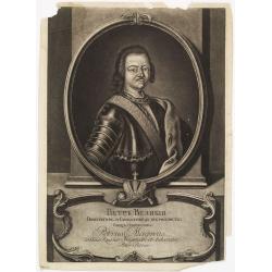
Petr Welikij imperator i camoderschez wserossinskij oschez oschetscheschewa (rossice). Petrus Magnus totius Russiae imperator et autocrator.
Mezzo tint by A. Zouboff, after J. G. Tannauer. Very rare variant of the portrait of Peter the Great with a Cristal Czar cross and crown. Another version is known where t...
Date: St. Petersburg, c. 1740
Selling price: ????
Please login to see price!
Sold in 2014
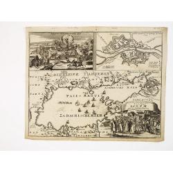
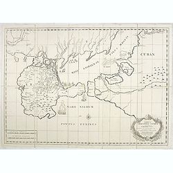
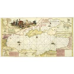
Accurater Grundriss und gegend des vestung Asoph samt der Russischen Belagerung.
A map of the Black Sea with in top a plan and siege of the town of Asoph, "Prospect und Belagerung der Vestung Asoph” and "Plan “Wahrer Grundriß der Vestun...
Date: Germany, c.1740
Selling price: ????
Please login to see price!
Sold in 2010
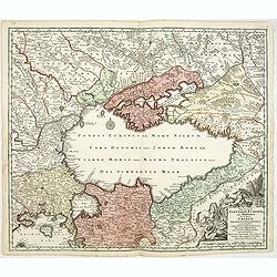
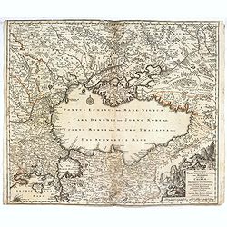
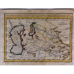
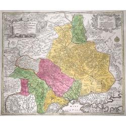
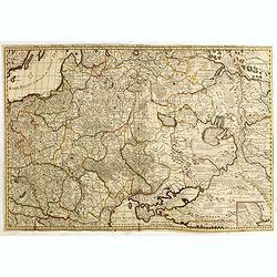
Nova et accurata Tartariae Europae seu Minoris et in specie Crimeae. . .
Rare map of the Black Sea area, showing Southern Russia, including the Ukraine, Cossack Regions and the Southern part of Muscovy, parts of Lithuania, and Poland In lower ...
Date: Augsburg, 1740
Selling price: ????
Please login to see price!
Sold in 2011
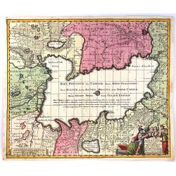
Afteekening van 8 voorname havens aen de west kust van de Caspische Zee.
Detailed chart of eight important harbors at the Caspian Sea. Remarkable the highly detailed chart.Including "The Reede van Abscharon", "Zalif Bakinskaia o...
Date: Amsterdam, c. 1740
Selling price: ????
Please login to see price!
Sold in 2012
Nova et Accurata Tartariae Europae seu Minoris et in specie Crimeae Deliniato Geographica...
Very detailed map of the Black Sea and the regions surrounding it, with parts of Asia Minor, Turkey, Bulgaria, Beesarabia, Ukraine and Crimea, Armenia, Georgia, etc. Wit...
Date: Augsburg, 1740
Selling price: ????
Please login to see price!
Sold in 2013
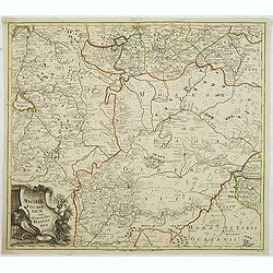
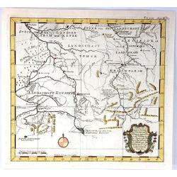
Potentissimo Borussorum Regi Friderico Wilhelmo Maiestate, Fortitudine Clementia Augustissimo Hancce Lithuaniam Borussicam : in qua luca coloniis Salisburg., ad incolendum Regio nutu concessa chorographice exhibentur D. D. D. Regiae Suae Maiestatis'
Upper part of a 2-sheet map of an area of Lithuania and Eastern Prussia (Russian province of Kaliningrad) stretching from Klaipeda (Memel) in the north to Goldap in the s...
Date: Nuremberg, ca. 1740
Selling price: ????
Please login to see price!
Sold in 2016
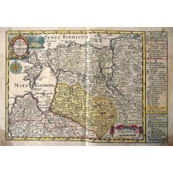
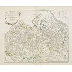
Ingermanlandiae seu Ingriae novissima tabula luci tradita.
Map shows the surrounding of St. Petersburg with a beautiful cartouche and a total view of St. Petersburg.
Date: Nuremberg, 1740
Selling price: ????
Please login to see price!
Sold in 2014
Nova et accuratissima Maris Caspii hactenus maxomam partem nobis...
Map shows the Caspian Sea and its bordering countries
Date: Augsburg, 1740
Selling price: ????
Please login to see price!
Sold in 2014
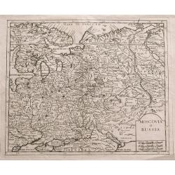
Moscovia o Russia.
Unusual map of European Russia centered on Moscow. Extends from Finland and the Baltics until Astrakhan and Crimea. A large Poland seems to extend into today's Russia. Th...
Date: Venice, 1740
Selling price: ????
Please login to see price!
Sold in 2014
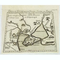
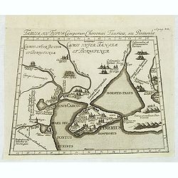
Verus Chersonesi Tauricae Seu Crimea Conspectus adjacentium item Regionem itinerisq ab Exercitu Ruthemo Ao MDCCXXXVI et MDCCXXXVII adversus Tattaros Susceptis . . .
Map of the environs of the Crimea, showing the route of the Russian Army in its expedition against the Tartars in 1736 and 1737. Showing detailed movements, including enc...
Date: St Petersburg, Academy of Sciences, 1740
Selling price: ????
Please login to see price!
Sold in 2015
Nova et accurata Tartariae Europae seu Minoris et in specie Crimeae. . .
Rare map of the Black Sea area, showing Southern Russia, including the Ukraine, Cossack Regions and the Southern part of Muscovy, parts of Lithuania, and Poland In lower ...
Date: Augsburg, 1740
Selling price: ????
Please login to see price!
Sold in 2016
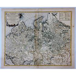
Mappae Imperii Moscovitici . . .
An ORIGINAL 18th century copperplate engraved map by De L'isle. Published in Augsburg by M. Seutter. NICELY detailed and beautifully engraved. Archangel is just left of c...
Date: Augsberg, 1740
Selling price: ????
Please login to see price!
Sold in 2019
Nova et accurata Tartariae Europae. . . Crimeae. . .
An extremely rare, very large carte-a-figure map of the Black Sea area. With decorative title cartouche and surrounded by four borders with 10 city views, each accompanie...
Date: Augsburg, 1740
Selling price: ????
Please login to see price!
Sold in 2019
Die Europaeische oder kleine Tartarey, nebst den angraentzenden Laendern. . ..
Showing the Black Sea region. Uncommon map from the "Atlas Selectus" by the German cartographer Johann Georg Schreiber (1676-1750). Schreiber followed in the fo...
Date: Leipzig, 1741
Selling price: ????
Please login to see price!
Sold in 2015
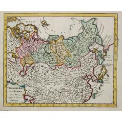
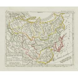
T Russische Ryk zoo in Europa als in Asia.
A map of the Russian empire both in Europe and Asia. Also depicting China and Japan.
Date: Amsterdam, 1742
Selling price: ????
Please login to see price!
Sold
A correct chart of the Baltick or East Sea from ye Sound to St. Petersburg. . .
Attractive uncommon sea chart of the Baltic Sea. Inset plan of St Petersburg (97x131mm.) . Compass rose and rhumb lines. Decorative title cartouche. Engraved by R.W. Seal...
Date: London, 1742
Selling price: ????
Please login to see price!
Sold in 2015
Het oosterdeel van de Moscoviesche Tarters. . .
Scarce map of Russia. This map is credited to Guillaume De l'Isle.
Date: Deventer, Almelo, 1742
Selling price: ????
Please login to see price!
Sold in 2014
Carte nouvelle de Moscovie represente la partie Septentrionale dressée par G.De L'Isle. . .
Rare map covering the area north of Moscow, including Lapland. Prepared by G. de L'Isle.
Date: Amsterdam, 1742
Selling price: ????
Please login to see price!
Sold in 2015
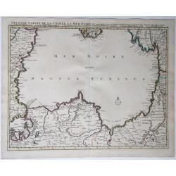
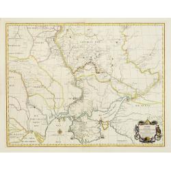
Seconde partie de la Crimee, la Mer Noire &c.
A map of the Black Sea with the coasts of the surrounding countries. From Istanbul (Constantinople) over Romania, Bulgaria, the southern tip of the Crimean, Russia, Georg...
Date: Amsterdam, 1742
Selling price: ????
Please login to see price!
Sold in 2021
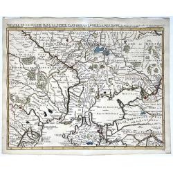
Theatre de la guerre, Petite Tartarie, Crimee, Mer Noire.
A map of the Crimea and the surrounding regions by Guillaume de Lisle, 1675-1726; Covens et Mortier, 1742. Full title and impressum above: 'Theatre de la guerre dans la P...
Date: Amsterdam, 1742
Selling price: ????
Please login to see price!
Sold in 2021
Carte pour les Voyages de Rubruquis, Marco Polo Jen-Kin-son & ca.
Dutch version of the map representing Europe and northern Asia, showing the routes of explorers looking east. These include Marco Polo's trip to China, Jenkinson's route ...
Date: Paris, 1744
Selling price: ????
Please login to see price!
Sold in 2008
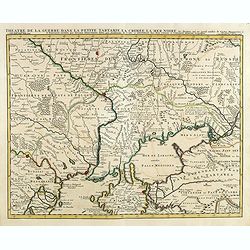
Theatre de la Guerre Dans la Petite Tartarie, La Crimee, la Mer Noire, &c..
Detailed map prepared by Guillaume Delisle focusing on the Black Sea with wonderful detail of the surrounding regions. Shows watershed, villages and cities, mountains. Lo...
Date: Amsterdam c. 1744
Selling price: ????
Please login to see price!
Sold in 2014
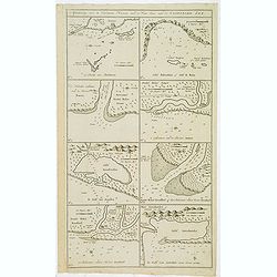
![[2 maps and one text sheet] Theatrum Belli A° MDCCXXXVII. . . / Verus Chersonesi Tauricae Seu Crimea Conspectus adjacentium item Regionem itinerisq ab Exercitu Ruthemo Ao MDCCXXXVI et MDCCXXXVII adversus Tattaros Susceptis . . .](/uploads/cache/35503-250x250.jpg)
[2 maps and one text sheet] Theatrum Belli A° MDCCXXXVII. . . / Verus Chersonesi Tauricae Seu Crimea Conspectus adjacentium item Regionem itinerisq ab Exercitu Ruthemo Ao MDCCXXXVI et MDCCXXXVII adversus Tattaros Susceptis . . .
Set of 2 copper engraved maps and a text sheet from the observations of Guillaume de l'Isle for the St.Petersburg' Academie des Sciences. Set of maps of part of the Ukrai...
Date: Amsterdam, ca. 1744
Selling price: ????
Please login to see price!
Sold in 2015
Charte derer von der Russischkeyser Armee im Jahr 1736 zwischen und an dem Dnieper und Donn wieder die Turcken und Tartarn siegreich unternommenen Kriegs-Operationen.
Scarce map illustrating the territories between the rivers Dnieper and Donn felt under Russian domination in 1736. The map is sometimes bound in the Atlas Russicus, print...
Date: Srt. Petersbourg, 1745
Selling price: ????
Please login to see price!
Sold in 2008
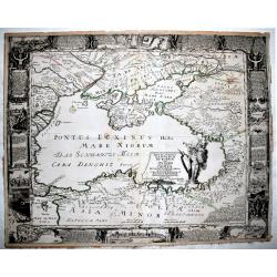
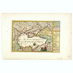
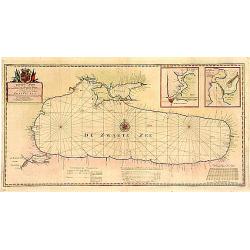
Pontus Euxinus of niewe en Naaukeurige paskaart van de Zwarte Zee. . .
Beautifully engraved map of the Black Sea prepared by Willem Witsen. This is the rare Ottens edition, where the address of Renard is replaced by the address of R. and J. ...
Date: Amsterdam, 1745
Selling price: ????
Please login to see price!
Sold in 2010
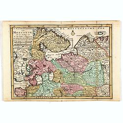
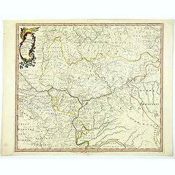
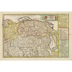
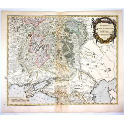
Moscoviae gubernium cum Adiacentibus regionibus. . .
Detailed map of center of Russia. Showing the cities Moscow, Twer, Jaroslaw. This map was included in the important Atlas Russicus, the first atlas of Russia to be publis...
Date: St Petersburg, 1745
Selling price: ????
Please login to see price!
Sold in 2011
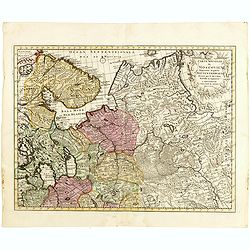
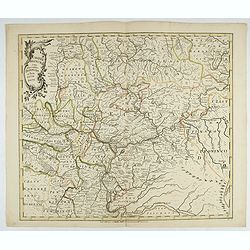
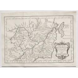
Casaniae Regnum cum Adiacentibus Provinciis et Parte Fluvii Volgae.
From the first regional atlas of Russia, published by the Academy of Sciences in St. Petersburg, expanding on the cartographic work done previously by Ivan K. Kirilov. Ou...
Date: St. Petersburg, 1745
Selling price: ????
Please login to see price!
Sold in 2020
Casaniae Regnum cum Adiacentibus Provinciis et Parte Fluvii Volgae.
From the first regional atlas of Russia, published by the Academy of Sciences in St. Petersburg, expanding on the cartographic work done previously by Ivan K. Kirilov. Ou...
Date: Academy of Sciences, St. Petersburg, 1745
Selling price: ????
Please login to see price!
Sold in 2025
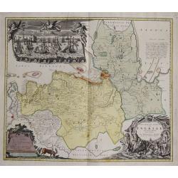
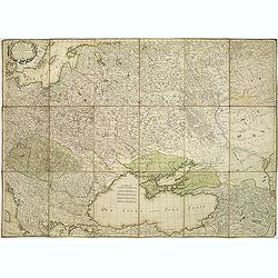
![[Lot of 11 maps of Russia]](/uploads/cache/48304-250x250.jpg)
[Lot of 11 maps of Russia]
Lot of 11 maps of Russia, diiferent size, diofferent dates.
Date: Augsburg, 1745
Selling price: ????
Please login to see price!
Sold in 2022
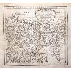
Lot of four maps showing Siberia and parts of Northern Russia.
Carte de la Siberie . ., 1754. Detailed overview of Siberia, showing cities, towns, mountainous and forested areas, and the region's numerous rivers. Route tracks of the...
Date: Paris, ca.1746
Selling price: ????
Please login to see price!
Sold in 2008
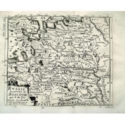
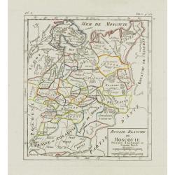
RUSSIE BLANCHE OU MOSCOVIE par N. de Fer
Charming map of North-Eastern Europe and parts of Russia. Includes Riga, Moscow, Novgorod, Samara, the Volga river, the White Sea, etc. Very detailed map with many plac...
Date: Paris, 1746
Selling price: ????
Please login to see price!
Sold in 2012
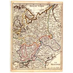
La Moscovie.
Fine original colored map of Russia in Europe by George Louis La Rouge.
Date: Paris, 1746
Selling price: ????
Please login to see price!
Sold in 2015
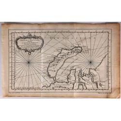
Partie de la Mer Glaciale Contenant la Nouvelle Zemble et le Pais des Samoiedes.
A detailed map of Nova Zembla and part of the northeast passage in northern Russia. It includes a decorative title cartouche. Produced by Bellin for the L'Histoire Genera...
Date: Paris, 1746
Selling price: ????
Please login to see price!
Sold in 2018
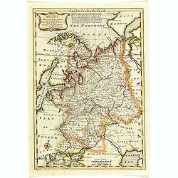
A New & Accurate map of MOSCOVY or Russia in Europe with its Aquisitions. . .
Decorative 1747 copper engraved map of Russia by Emanuel Bowen from "A Complete System of Geography". Showing the region from northern part of Norway to the Bla...
Date: London, 1747
Selling price: ????
Please login to see price!
Sold in 2013
Suite de la Carte de la Siberie et le Paijs de Kamtfchatka.
A detailed map of Russia covering the coast of Siberia and Kamchatka, the island of Sakhalin and part of Tatary. Near the top is the voyage track of Semen Dezhnev who led...
Date: Paris, 1747
Selling price: ????
Please login to see price!
Sold in 2015
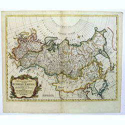
A New and Accurate map of the Whole Russian Empire, as contained both in Europe and Asia...
A pleasant map, by the English cartographer Thomas Kitchin, of the vast Russian Empire, as it was during the middle of the eighteenth century.The map has been colored to ...
Date: London, 1747
Selling price: ????
Please login to see price!
Sold in 2017
A New & Accurate Map of Moscovy, or Russia in Europe, with its Acquisitions.
A quaint detailed map of European Russia by Emmanuel Bowen.
Date: London, 1747
Selling price: ????
Please login to see price!
Sold in 2016
Anhang zu dem Karten von dem Orenburger.
Copper engraved map of Siberia, Russia, from the Caspian Sea to Tashkent, in Uzbekistan. The map depicts the Aral–Caspian Depression, a lowland depression straddling Eu...
Date: Germany, 1747
Selling price: ????
Please login to see price!
Sold in 2018
Kurtz von Ernigen Provinzen in Siberien und den Groenzen Yegen China
An unusual antique map of central Siberia featuring Tomsk, Krasnoarsk and Kuznets Oblests (provinces). The bottom of the map borders on China. It features a fancy floral ...
Date: Germany, 1747
Selling price: ????
Please login to see price!
Sold in 2017
A New & Accurate Map of Moscovy, or Russia in Europe, with its Acquisitions.
A detailed map of European Russia by Emmanuel Bowen. It depicts the European portion of Russia extending from the Gulf of Finland to the Ural Mountains. The map offers ex...
Date: London, 1747
Selling price: ????
Please login to see price!
Sold in 2018
Carte Generale de l'Empire de Russie. (2 maps)
Highly decorative copper-engraved map representing the Russian empire. With superb title cartouche and two explanatory cartouches with text translated in Latin and French...
Date: Amsterdam c. 1748
Selling price: ????
Please login to see price!
Sold
Russie Blanche ou Moscovie. . .
Nice small map of European Russia, framed by "Suede", "Pologne", "Ukraie" ou "Cosaquie", "...
Date: Paris, later than 1748
Selling price: ????
Please login to see price!
Sold in 2009
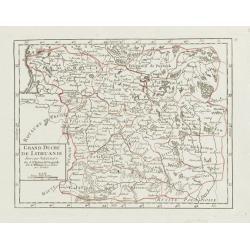
Grand Duché de Lithuanie divisé par Palatinats.
Small detailed map centered on Lithuania and Belarus. From Atlas Portatif Universel, by Robert de Vaugondy.Unrecorded state with erased date. Page 38 outside border top r...
Date: Paris, later than 1748
Selling price: ????
Please login to see price!
Sold
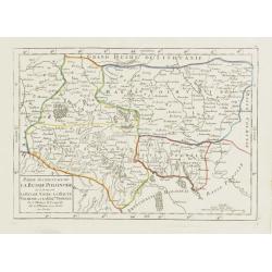
Partie Occidentale de la Russie Polonoise.. Haute Podolie.
Small detailed map showing the western part of Ukraine. From Atlas Portatif Universel, by Robert de Vaugondy.Unrecorded state with erased date. Page 40 outside border top...
Date: Paris, later than 1748
Selling price: ????
Please login to see price!
Sold in 2008
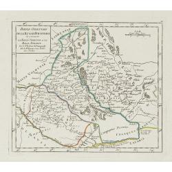
Partie orientale de la Russie Polonaise, où se trouvent la Basse Volhynie et la Basse Podolie.
Small detailed map showing the eastern part of Ukraine, with Volhynia and Podillia. Centered on the course of the Dnieper river.From Atlas Portatif Universel, by Robert d...
Date: Paris, later than 1748
Selling price: ????
Please login to see price!
Sold in 2021
Carte générale de l'empire de Russie.
According to the description panel in lower left : the map covers the Empire of Peter the Great.This important is based on maps from the Bering expedition and on De L'Isl...
Date: Amsterdam, ca.1748
Selling price: ????
Please login to see price!
Sold in 2009
Tabula, seu Typus Camporum Chersonesi . . .
Rare map of part of the Ukraine and the Black Sea region, published in the second edition of Martinus Broniovius "Tartariae description ..."
Date: Vienna, 1746-1748
Selling price: ????
Please login to see price!
Sold in 2012
Tabula, seu Typus Camporum Chersonesi Tauricae, seu Peninsulae.
Rare map of part of the Ukraine and the Black Sea region, published in the second edition of Martinus Broniovius "Tartariae description ..." His work appeared f...
Date: Vienna, 1746-1748
Selling price: ????
Please login to see price!
Sold in 2013
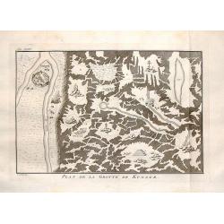
Plan de la Grotte de Kungur.
Interesting map of the Kungeron fortress in Krai Russia in the Ural Mountains. This is the site of the Kungur ice cave.Published in Prevost's "L'Histoire Generale de...
Date: The Hague, 1748
Selling price: ????
Please login to see price!
Sold in 2016
Carte de l'Asie Minevre. . .
A striking map centred on the Black Sea, and the geographical regions surrounding it. Map also shows Asia Minor, Crete, Cyprus, northern Syria, Iraq, Georgia, the Crimea,...
Date: Nuremburg, 1748
Selling price: ????
Please login to see price!
Sold in 2018
Carte Générale de l'Empire des Russes Contenant la Siberie.. le Kamtchatka.
Small detailed map of Russia. Extending southwards and eastwards to show Korea, Japan, Mongolia and part of China. The title has been reworked from the plate described by...
Date: Paris, later than 1749
Selling price: ????
Please login to see price!
Sold
Das gantze Russische Kaeyserthum mit allen seinen Laendern verfertiget von J. G. Schreibern in Leipzig.
Small scale map of Russia by J. G. Schreiber, from his "Atlas Selectus" from 1749, first published in 1740. Showing the area between Reval; Novaja Semlja; Japan...
Date: Leipzig, 1749
Selling price: ????
Please login to see price!
Sold in 2014
Die Hertzogthümer Curland und Liefland...
Unusual map of the Baltic area which nowadays is mainly covered by Latvia and Estonia. Extends from Libau to St. Petersburg in Russia, including Riga, Revel (Tallinn), Na...
Date: Leipzig, 1749
Selling price: ????
Please login to see price!
Sold in 2016
Carte de Karasm, Turkestan et Grand Bukarie...
The Timurids. A Central Asian Sunni Muslim dynasty, of Turko-Mongol descent, whose empire included the whole of Iran, modern Afghanistan, and modern Uzbekistan, as well a...
Date: Paris, 1749
Selling price: ????
Please login to see price!
Sold in 2021
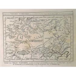
Carte de la Tartarie Occidentale. . .
A detailed copper engraved map of northeast Asia and Siberia, from Lake Baykal. Partie du Siberie in the north, Pays des Kalkas at the centre as well as Desert de Sable, ...
Date: Paris, 1749
Selling price: ????
Please login to see price!
Sold in 2019
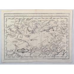
Carte de la Tartarie Occidentale pour Servir a L'Histooire General des Voyages.
A detailed map of Western Tartary, including Siberia, the Sable Desert, Mongolia and part of Northern China. Showing roads, towns, rivers, lakes, mountains, etc. In the c...
Date: Paris, 1749
Selling price: ????
Please login to see price!
Sold in 2021
Aan zyne .. Paskaart van de Zwarte Zee..
A very fine and rare chart of the Black Sea with inset plans of Bosporus and Istanbul and another inset of Kerchensky Strait. Prepared by J.van Woensel.Embellished with a...
Date: Amsterdam 1750
Selling price: ????
Please login to see price!
Sold
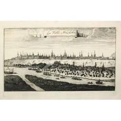
La Ville Tobolska.
A view of the town of Tobolska on the Irtis and Tobol rivers.
Date: Amsterdam, c. 1750
Selling price: ????
Please login to see price!
Sold
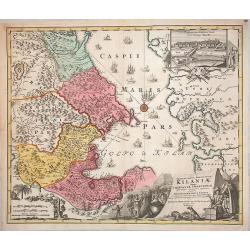
Provinciarum Persicarum Kilaniae nempe Chirvaniae Dagestaniae.
Very decorative map of the southern part of the Caspian Sea, Caucasus and Turkmenistan, by J B. Homann. A nice view of the city of Baku (the former Tereki) in a decorativ...
Date: Nuremberg, 1750
Selling price: ????
Please login to see price!
Sold in 2013
Partie Occidentale de l'Empire de Russie . . .
Map of the western part of the Russian Empire, north of the Black Sea and the Caspian Sea, Nova Zembla, including most of Finland.
Date: Paris, ca. 1750
Selling price: ????
Please login to see price!
Sold in 2009
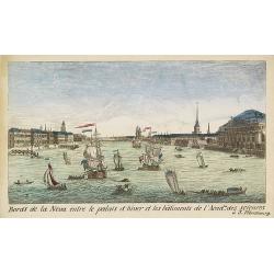
Bords de la Neva entre le palais d'hiver et les bâtiments de l'Acad.ie des Sciences à S.Pétersbourg.
Showing the Neva with the Winter Palace in St. Peterburg. J. Chereau was a publisher of optical prints, established in Paris, rue St.Jacques.In the eighteenth and ninetee...
Date: Paris, ca. 1750
Selling price: ????
Please login to see price!
Sold in 2012
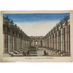
Péristijle d'un palais de S. Pétersbourg.
Showing an arcade at the Royal Palace of Saint Petersburg. J. Chereau was a publisher of optical prints, established in Paris, rue St.Jacques.In the eighteenth and ninete...
Date: Paris, ca. 1750
Selling price: ????
Please login to see price!
Sold in 2018
Tabula Geographica qua pars Russiae Magnae. . .
Homann's map is based upon the works of George von Mengden (1628-1702) a Livonian cartographer who worked for Peter the Great and Count Jacob Bruce [Graf Jakov Villimovic...
Date: Nuremberg, after 1750
Selling price: ????
Please login to see price!
Sold in 2010
Carte du théatre de la guerre presente entre les Russes, les Polonois et les Turcs. . .
Map of region between the Baltic sea and the Black Sea, published by Jean Lattré and prepared by R. Bonne. The map allowed the French public to follow the Russo-Turkish ...
Date: Bordeaux, c.1750
Selling price: ????
Please login to see price!
Sold in 2011
Amplissima Ucraniae Regio, Palatinatus Kioviensem et Braclaviensem...
An uncommon and attractive map of the Ukraine. With excellent detail of the topography, including rivers, hills, etc. Decorated with two attractive cartouches showing...
Date: Augsburg, c1750
Selling price: ????
Please login to see price!
Sold in 2012
Partie Occidentale de L'Empire de Russie
Detailed map of the western part of the Russian Empire, north of the Black & Caspian Seas, Nova Zembla and including most of Finland. Gilles Robert de Vaugondy (168...
Date: Paris, 1750
Selling price: ????
Please login to see price!
Sold in 2014
Nova et Accuratissima Maris Caspii....
Highly decorative map showing the Caspian Sea and the countries around it. Main cities / countries around it include: Baky / Baku in Aserbaidschan, Astrakhan / Astrakha...
Date: Augsberg, 1750
Selling price: ????
Please login to see price!
Sold in 2016

Carte du Kamtchatka
One of the best maps of the region from the 1700's. Handsome copper engraved map of the Kamtchatka peninsula with excellent detail showing topography, including several l...
Date: Paris, 1750
Selling price: ????
Please login to see price!
Sold in 2016
Partie Occidentale de L'Empire de Russie.
A highly detailed map of the Western Part of Russia, extending South to the Caspian and East to Irkurkoy and Ilimskoy. Interesting natural cartouche featuring two bears e...
Date: Paris, 1750
Selling price: ????
Please login to see price!
Sold in 2018
Partie Orientale de L'Empire de Russie en Asie...
An attractive and detailed map of the northeastern portion of Asia, including Russia, China, the Gobi Desert, etc. Included are cities, villages, rivers, mountain ranges ...
Date: Paris, 1750
Selling price: ????
Please login to see price!
Sold in 2017
Carte de la Tartarie Orientale. . .
A detailed copper engraved map of northeast Asia and Manchuria, showing the island "Sagallan Anga Hata" or "Isle de Bouche Noire". From Prevost's &quo...
Date: Paris, 1750
Selling price: ????
Please login to see price!
Sold in 2021
Nieuwe Paskaart van de gehele Swarte Zee Beginnende van Constantinopolen tot Azak opgestelt door G: van Keulen. . .
A highly detailed and rare chart of the Black Sea.A large title cartouche upper left, and a dedication to Peter Alexeowits (the Great).
Date: Amsterdam, 1751
Selling price: ????
Please login to see price!
Sold in 2010
Sades Belli in POLONIA et in Moscovia . . .
Scarce map including Lithuania, Russia, Ukraine, Curlandia, Livonia, Tartaria Minor, Walachia, Volhynia, etc. With a key in lower bottom. Small inset map of Astrakan regi...
Date: Amsterdam, 1751
Selling price: ????
Please login to see price!
Sold in 2015
Partie Méridionale de la Russie Européenne..
Detailed map of Ukraine, the Crimea and the northern part of the Caspian Sea.
Date: Paris 1752
Selling price: ????
Please login to see price!
Sold
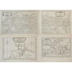
![[4 maps] Partie Orientale de l'Empire de Russie ? / Partie Occidentale de l'Empire de Russie ? / Partie Septentrionale de la Russie Européenne ? / Partie Méridionale de la Russie Européenne ?](/uploads/cache/99444-250x250.jpg)
[4 maps] Partie Orientale de l'Empire de Russie ? / Partie Occidentale de l'Empire de Russie ? / Partie Septentrionale de la Russie Européenne ? / Partie Méridionale de la Russie Européenne ?
Detailed maps of the different regions of Russia.
Date: Paris, 1752
Selling price: ????
Please login to see price!
Sold in 2010
Sibirie maxime Septentrionalis pars a Nova Semlja in oceanum orientalem . . .
Scarce map of Siberia engraved by Johann Eberhard Alber, who was a German copper engraver active from 1742-1757.
Date: Nuremberg, 1752
Selling price: ????
Please login to see price!
Sold in 2014
Partie Meridionale de la Russie Europeenne...
Large, finely engraved map showing topographical detail of mountains, rivers, lakes and forests. Moscow is in the upper center of the map and the Volga River in the east ...
Date: Paris , 1752
Selling price: ????
Please login to see price!
Sold in 2018
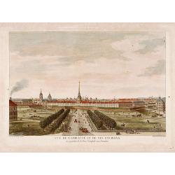
Vue de l'Amirauté et de ses environs.
Fine view of the admiralty buildings in St.Petersburg. Drawn and engraved under the direction of the imperial Academy of sciences and arts of Russia. After a design by De...
Date: Saint-Petersburg 1753
Selling price: ????
Please login to see price!
Sold
Partie Occidentale de l'Empire de Russie ou se trouve distinguée la Russie Européenne. . .
Detailed map of the European part of Russia.
Date: Paris, 1753
Selling price: ????
Please login to see price!
Sold in 2008
