Browse Listings in Europe > Russia / Baltic / Black Sea region
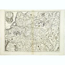
Lituania dedicata all. Illustrissimo signore Gio. Pietro Caualli secretario della serenissima Republica di ...
A scarce and very attractive detailed map of Lithuania and parts of Poland and the Baltic and includes numerous coats of arms in the body of the map and two large decorat...
Date: Venice, 1696
Selling price: ????
Please login to see price!
Sold in 2011
Lituania dedicata all. Illustrissimo signore Gio. Pietro Caualli secretario della serenissima Republica di ...
A scarce and very attractive detailed map of Lithuania and parts of Poland and the Baltic and includes numerous coats of arms in the body of the map and two large decorat...
Date: Venice, 1696
Selling price: ????
Please login to see price!
Sold in 2012
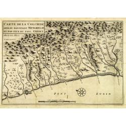
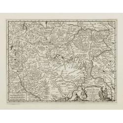
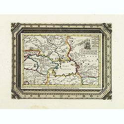
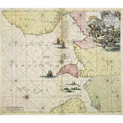
Carte de la Colchide appelée maintenant Mengrelie et par ceux du pays Odisci.
An early map showing the extent of the fortifications of the Ottoman Empire along the east of the Black Sea and in the foothills of the Caucasus. Vignettes of buildings, ...
Date: Paris, 1664-1696
Selling price: ????
Please login to see price!
Sold in 2012

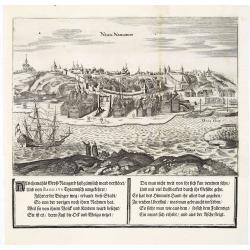
Nisen Navgorod.
An early of Nizhniy Novgorod (Gorky) on the Oka and Volga river. From the scarce Hamburg edition "Viel Vermehrte Moscowitische und Persianische Reisebeschreibung&qu...
Date: Hamburg, 1696
Selling price: ????
Please login to see price!
Sold
Kremelin Das Schloß in Muscau.
An early of the Kremlin in Moscow. From the uncommon Hamburg edition "Viel Vermehrte Moscowitische und Persianische Reisebeschreibung" by Adam Olearius.Underne...
Date: Hamburg, 1696
Selling price: ????
Please login to see price!
Sold in 2013
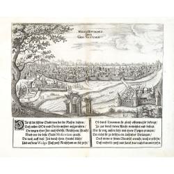
Weliki Novogord oder Gros-Navgard.
An early of tVeliki Novgorod. From the scarce Hamburg edition "Viel Vermehrte Moscowitische und Persianische Reisebeschreibung" by Adam Olearius.Underneath the...
Date: Hamburg, 1696
Selling price: ????
Please login to see price!
Sold in 2013
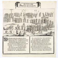
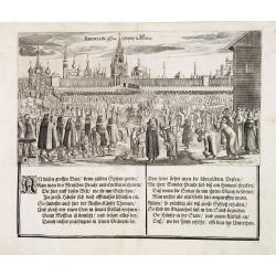
Eine Moscowitische Procession.
An view of a procession in Moscow. From the scarce Hamburg edition "Viel Vermehrte Moscowitische und Persianische Reisebeschreibung" by Adam Olearius.Underneath...
Date: Hamburg, 1696
Selling price: ????
Please login to see price!
Sold in 2023
Nisen Navgorod.
An early of Nizhniy Novgorod (Gorky) on the Oka and Volga river. From the scarce Hamburg edition "Viel Vermehrte Moscowitische und Persianische Reisebeschreibung&qu...
Date: Hamburg, 1696
Selling price: ????
Please login to see price!
Sold
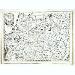
Lituania dedicata all. Illustrissimo signore Gio. Pietro Caualli secretario della serenissima Republica di. . .
A rare and very attractive detailed map of Lithuania and parts of Poland and the Baltic that includes numerous coats of arms in the body of the map, and two large decorat...
Date: Venice, 1696
Selling price: ????
Please login to see price!
Sold in 2018
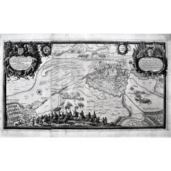
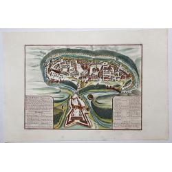
Delineatio Regiae urbis Rigae. . .
A large, detailed, and spectacular plan of Riga during the Siege of 1656. It is is filled with battles, armies, and a large number of cavalry soldiers in the foreground. ...
Date: Nuremberg, 1696
Selling price: ????
Please login to see price!
Sold in 2020
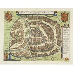
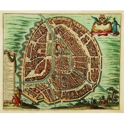
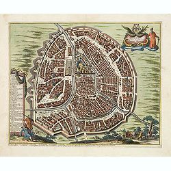
Moscovia urbs Metropolis totius Russiae Albae.
Detailed bird's-eye town-plan of Moscow from Frederick de Wit's rare townbook. With a key (1-20) to important spots in town. Frederick de Wit published after 1694 a town ...
Date: Amsterdam, 1697
Selling price: ????
Please login to see price!
Sold in 2012
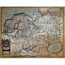
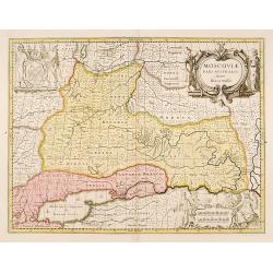
La Russie Blanche ou MOSCOVIE.
Scarce miniature map centered on Moscow, from the rare atlas " El atlas abreviado, o compendiosa geografia del mundo antiguo, y nuevo. . ." by Francesco de Affe...
Date: Antwerp, Jan Duren, 1698
Selling price: ????
Please login to see price!
Sold in 2012
La Russie Blanche ou Muscovie
European Russia, including Ukraine.
Date: Amsterdam 1700
Selling price: ????
Please login to see price!
Sold
La Russie Blanche ou Muscovie
Uncommon map of European Russia, including Ukraine.
Date: Amsterdam, 1700
Selling price: ????
Please login to see price!
Sold
Russie Blanche ou Moscovie
Attractive copper engraved map of European Russia showing its political divisions, major topographical features, cities and towns. It is embellished with a strapwork titl...
Date: Amsterdam, 1700
Selling price: ????
Please login to see price!
Sold in 2008
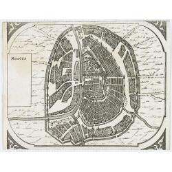
Moscua.
Very rare bird's-eye view of Moscow, intended to be used for a "carte à figures" wall-map, published by Frederick de Wit, to accompany the his wall map of Euro...
Date: Amsterdam, 1672-1700
Selling price: ????
Please login to see price!
Sold in 2009
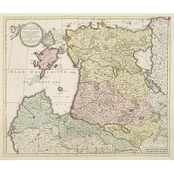
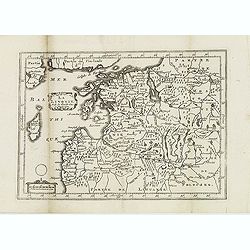
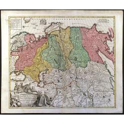
ucatuum Livonia et Curlandiae Novissima Tabula in Quibus sunt Estonia Litlandia et. . .
Nice engraved map of Estonia and Lithuania and parts of Russia. Decorative title cartouche supported by cherubs in the upper left corner.Uncommon issue published by Joach...
Date: Amsterdam, 1700
Selling price: ????
Please login to see price!
Sold in 2010
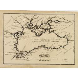
![[No title] La mer noire, autrefois Pont-Euxin. . .](/uploads/cache/28941-250x250.jpg)
[No title] La mer noire, autrefois Pont-Euxin. . .
Maps of the region Black sea, showing the cities of Constantinople, Heraclee, Kafa. . . From his 'Atlas Curieux'.
Date: Paris, 1700
Selling price: ????
Please login to see price!
Sold in 2010
Ponti euxini cum periplus auctore N.Sanson.
A very rare map of the Black Sea area prepared by Nicolas Sanson. The map is in stunning full colors.
Date: Amsterdam, 1700
Selling price: ????
Please login to see price!
Sold in 2010
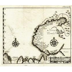
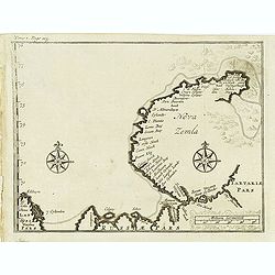
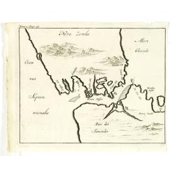
Nova Zemla.
Unknown copper-engraved map of Nowaja Semlja (Новая Земля). Shows t...
Date: ca.1700
Selling price: ????
Please login to see price!
Sold in 2011
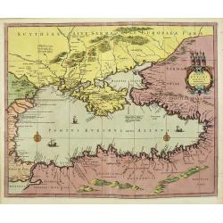
A new map of Sarmatia Europaea Pannonia and Dacia. . .
Decorative map of the region between the Baltic, Adriatic and Black Seas. This decorative map was part of a set of 22 maps dedicated to William, Duke of Gloucester, who w...
Date: Oxford, 1700
Selling price: ????
Please login to see price!
Sold in 2011
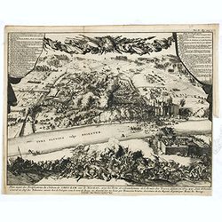
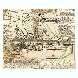
Plan exact des fortifications du Château de Choczim sur le Niester : avec le forts et retranchements de l'Armée des Turcs, défaite en 1673 par Jean Sobieski. . .
Depicting the victory of Jan Sobieski over the Turks at Khotyn in Ukraine in 1673. The victory allowed the Poles to revoke the unfavorable Peace of Buczacz and set the st...
Date: Leiden, P. van der AA, ca. 1700
Selling price: ????
Please login to see price!
Sold in 2015
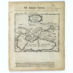
Tartaria in Europe.
This map appeared in Modern's rare 'Atlas Terestris', first published in 1687, depicting the regions surrounding the Black Sea.It features a pleasant scrolled title carto...
Date: London, 1700
Selling price: ????
Please login to see price!
Sold in 2016
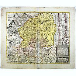
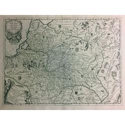
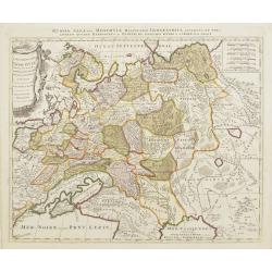
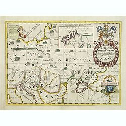
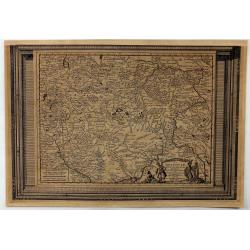
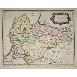
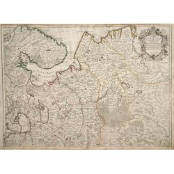
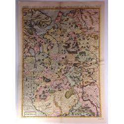
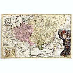
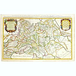
Magni ducatus Lithuaniae Caeterarumq Regionum illi adiacentium exacta descrip. . .
Highly detailed map of Lithuania and Belarus between Riga, Smolensk, Kiev, Cracow and Konigsberg, including two inset maps of the Dnieper River from Cherkasy to the Black...
Date: Amsterdam, 1700
Selling price: ????
Please login to see price!
Sold in 2016
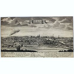
Moskow.
A rare view of Moscow.
Date: Germany, ca. 1700
Selling price: ????
Please login to see price!
Sold in 2017
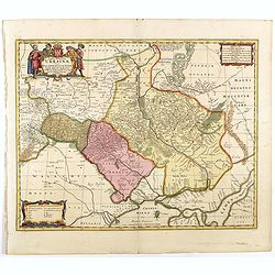
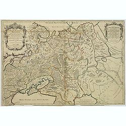
Typus Generalis Ukrainae sive Palatinatuum Podoliae, Kioviensis et Braczlaviensis terras nova delineatione exhibens
Key map originally engraved by Johannes Janssonius in about 1656 and based on Guillaume La Vasseur de Beauplan's map of the region published in "Description d'Ukrain...
Date: Amsterdam, 1690 - 1700
Selling price: ????
Please login to see price!
Sold in 2020
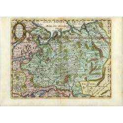
La Moscovie Meridionale...
Detailed map centered on area north of Moscow, including part of Finland and Lapland. Charming title cartouche in lower right corner. This well executed engraving was pu...
Date: Leiden, 1700
Selling price: ????
Please login to see price!
Sold in 2018
![Sea of Azov The Eastern Part of the Sea [usually known as] Palus Maeotis and now Called the Sea of Azov...(Vostochnaja chast' morja palus meotis i nyne nazyvaetsja azovskoe more...)](/uploads/cache/43912-250x250.jpg)
Sea of Azov The Eastern Part of the Sea [usually known as] Palus Maeotis and now Called the Sea of Azov...(Vostochnaja chast' morja palus meotis i nyne nazyvaetsja azovskoe more...)
Very rare and important chart of the eastern part of the Sea of Azov, the Kerch Strait and parts of the Black Sea. This important chart was compiled from measurements an...
Date: Moscow, Kremlin Armoury, 1701
Selling price: ????
Please login to see price!
Sold in 2019
Moscou, Capitale de la Moscovie..
Detailed bird's-eye view of the town of Moscow.
Date: Leiden, 1702
Selling price: ????
Please login to see price!
Sold in 2008
La Moscovie meridionale..
Detailed map centered on Moscow. Charming title cartouche in lower right corner.
Date: Leiden, 1702
Selling price: ????
Please login to see price!
Sold in 2008
Nova Zemla.
Uncommon map of Novaya Zemlya with un unknown east coast. Based on info from Barentz. arctic voyage.From the French reissue of the account of early Dutch voyages first pu...
Date: Amsterdam, E. Roger, 1702
Selling price: ????
Please login to see price!
Sold in 2012
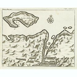
(Insula Kilduyn.)
Uncommon map of part of the coast along the Barents Sea with the island of Kildin, offshore of the river and town of Cola (Murmansk). Originally made to illustrate Willem...
Date: Amsterdam, E. Roger, 1702
Selling price: ????
Please login to see price!
Sold in 2012
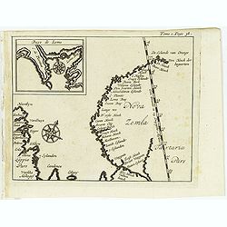
(Map of Nova Zembla with inset of Baye de Loms.)
Map of Nova Zembla with inset of Baye de Loms (5x7mm.).From the French reissue of the account of early Dutch voyages first published in 1608 by Commelin. The French trans...
Date: Amsterdam, E. Roger, 1702
Selling price: ????
Please login to see price!
Sold in 2012
Delineatio Spitsbergiae.
Map of Sipitsbergen.From the French reissue of the account of early Dutch voyages first published in 1608 by Commelin. The French translation was carried out by René Aug...
Date: Amsterdam, E. Roger, 1702
Selling price: ????
Please login to see price!
Sold in 2012
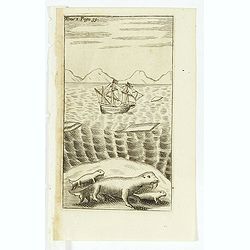
(Dutch ship in Arctic waters with 3 sea lions in the foreground)
From the French reissue of the account of early Dutch voyages first published in 1608 by Commelin. The French translation was carried out by René Augustin Constantin de ...
Date: Amsterdam, E. Rogers, 1702
Selling price: ????
Please login to see price!
Sold in 2012
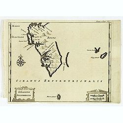
(Nova Zemla / Ocea nus Septen trionalis. )
Uncommon map of the Strait Nassau, between Nova Zembla and the Russian mainland. Originally made to illustrate Willem Barentz. arctic voyage. From the French reissue of t...
Date: Amsterdam, E. Roger, 1702
Selling price: ????
Please login to see price!
Sold in 2012
Moscou, Capitale de la Moscovie. . .
Detailed bird's-eye view of the town of Moscow with the Kremlin and old city, Kitay-gorod, at center. These are surrounded by successive rings of fortifications. The plan...
Date: Leiden, 1702
Selling price: ????
Please login to see price!
Sold
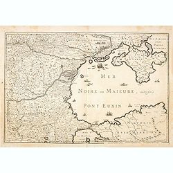
(Mer Noire ou Maieure, Pont Euxin.)
Very rare and detailed map of the Black Sea area prepared by Placide de Sainte-Hélène (1648-1734). and engraved by Claude-Auguste Berey (1651-1732).The map is of partic...
Date: Paris, 1702
Selling price: ????
Please login to see price!
Sold in 2014
La Curlande duche et Semigalle autrsois de la Livonie
La Curlande duche et Semigalle autresois de la Livoniel / La Samogitie duche en Lituanie / Par le Sr. Sanson d?Abbeville Geogrordae de S.M. avecq Privilege Re pour vingt ...
Date: Paris, 1703
Selling price: ????
Please login to see price!
Sold in 2008
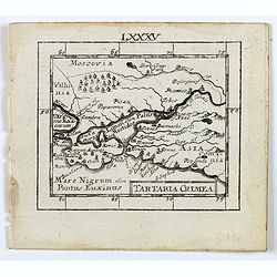
Tartaria Crimea.
A lovely miniature map of the region of Crimea. For such a small map it renders a wealth of detail, with mountains, forests, river, towns, cities all engraved in some det...
Date: Ulm, c 1703
Selling price: ????
Please login to see price!
Sold in 2016
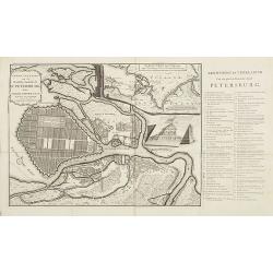
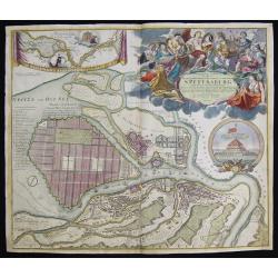
Grond - Tekening van de Russische Hoofdstadt St. Petersburg door Czaer Pieter de Eerste in 't jaer 1703 aengelegt.
Uncommon city plan of Saint Petersburg with keys to the right chart A-E, 1- 66. In upper right an inset map of the river Neva. Text is in Dutch.
Date: Utrecht, 1705
Selling price: ????
Please login to see price!
Sold in 2009
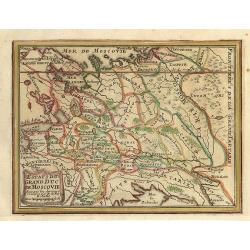
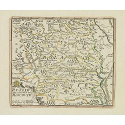
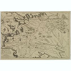
Estats du Grand Duc de Moscovie.
Small map of a part of Rusland.
Date: Paris, 1705
Selling price: ????
Please login to see price!
Sold in 2009
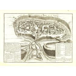
Kamieniec Podolski Ville forte des Estats de pologne et de la Haute Podotie. . .
Uncommon bird's eye view of the city of Kamianets-Podilskyi, located in western Ukraine. The print has in the lower left corner an explanatory panel with numbered (1-10) ...
Date: Paris, 1705
Selling price: ????
Please login to see price!
Sold in 2010
Estats du Grand Duc de Moscovie. . .
Lovely small map of Russia, Poland and reaching in the south to the Ukraine with Kiev. From De Fer's Atlas Curieux . . .
Date: Paris, c.1705
Selling price: ????
Please login to see price!
Sold in 2020
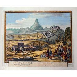
Derbent, een stadt gelegen aen de Kaspische Zee / Derbent, Atropatiae, sive Minoris Mediae urbs...
Rare view of Derbent the southern-most city in Russia, located near the Caspian Sea, supposedly the oldest city in Russia. Detailed and decorative view with numerous figu...
Date: Amsterdam, c1705
Selling price: ????
Please login to see price!
Sold in 2011
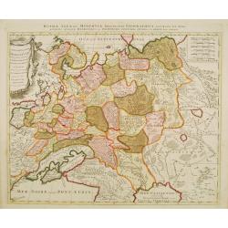
Novissima Russiae Tabula.
A fine and attractive map of Russia.Published by the Allard family in Amsterdam.
Date: Amsterdam, 1705
Selling price: ????
Please login to see price!
Sold in 2017
Kamieniec Podolski Ville forte des Estats de pologne et de la Haute Podolie. . .
An uncommon bird's eye view of the city of Kamianets-Podilskyi, located in western Ukraine. The print has in the lower left corner an explanatory panel with numbered (1-1...
Date: Paris, 1705
Selling price: ????
Please login to see price!
Sold in 2020
Carte de Moscovie.
Map of northwest region of Russia, including Russian Lapland and the White Sea, with a decorative cartouche in the upper right corner.
Date: Paris, 1706
Selling price: ????
Please login to see price!
Sold in 2010
La Livonie. . .
A detailed map of Latvia and Estonia, centered on Riga. From his "Atlas Portatif, ou le nouveau Theatre de la Guerre en Europe, Contenants les cartes geographiques, ...
Date: Amsterdam, 1706
Selling price: ????
Please login to see price!
Sold in 2012
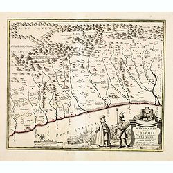
De Landschappen der Percoptize en Nogaize Tartars, Circassen, Mingrebilianen en Georgianen met die vande Crim
Pieter van der Aa was a prolific publisher. He published a.o. 'Naaukeurige versameling der gedenkwaardigste zee- en land-reysen', a series of accounts of voyages (1706-08...
Date: Leiden, 1707
Selling price: ????
Please login to see price!
Sold in 2009
Veltslagh by Poltawa inde Ukrainie, gewonnen door den Czaar van Moskovie op den Kon. v. Sweden . . . / Pugna ad Poltawan in Ukrainia. . .
Detailed engraving of the Siege of Poltawa in Ukraine. Published in "Schouwburg van den oorlog, beginnende van koning Karel den II. tot op Koning Karel den III"...
Date: Amsterdam, after 1708
Selling price: ????
Please login to see price!
Sold in 2015
Moscovia pars Australis.
Prepared by Isaac Massa, a Dutch map-maker who travelled to Russia, returning to Holland in 1609, bringing with him a large amount of original cartographic manuscript mat...
Date: Amsterdam 1710
Selling price: ????
Please login to see price!
Sold in 2011
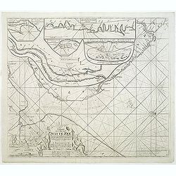
Paskaart van de Mont van de Witte Zee,. Beginnende van Tiepena tot Pelitza, als mede van C. Cindenoes tot Catsnoes.
Fine sea chart of the southern part of the Barents Sea, oriented to the West. With 5 inset maps: - Swetenoes, de Kust van Laplandt, Lombascho, ''T Vaste Landt van Lapland...
Date: Amsterdam, c.1710
Selling price: ????
Please login to see price!
Sold in 2011
Topographische Vorstellung der Neuen Russischen Haupt-Residenz und See- Stadt St. Petersburg sammt ihrer zu erst aufgerichten Festung
Map shows a city map of St. Petersburg ,a beautiful cartouche, a location map of St. Petersburg and Chroncastle .
Date: Nuremberg, 1710
Selling price: ????
Please login to see price!
Sold in 2014
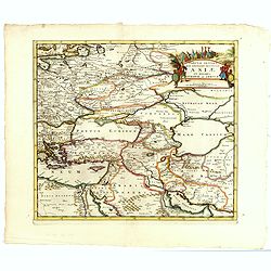
Tabula Altera Quae Continet Potissima Asiae et Reliqua Europae ac Africae.
Uncommon map covering a broad region centered on the Black and Caspian Seas. This was a region long disputed between the Christian and Islamic empires and the title carto...
Date: Amsterdam, 1710
Selling price: ????
Please login to see price!
Sold in 2015
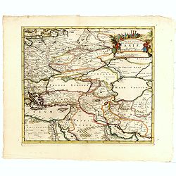
Tabula Altera Quae Continet Potissima Asiae et Reliqua Europae ac Africae.
Uncommon map covering a broad region centered on the Black and Caspian Seas. This was a region long disputed between the Christian and Islamic empires and the title carto...
Date: Amsterdam, 1710
Selling price: ????
Please login to see price!
Sold in 2019
Carte Pour l\'Intelligence des Affaires Presente Des Turcs, des Tartares, des Hongrois, des Polonois, des Suedois, et des Moscovites Aux Environs . . .
Scarce Nicolas de Fer map of the region centred on Russia and extending east to the mouth of the Volga in the Caspian Sea, west to the Baltic, South to the Black Sea, Ita...
Date: Paris, 1711
Selling price: ????
Please login to see price!
Sold in 2014
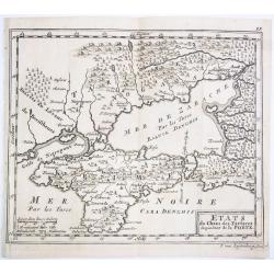
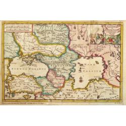
ETATS du Cham des Tartares dependent de la Porte.
A rare copper engraved map of the southern Ukraine and the Crimea peninsula. From 'Theatre complete et particularise de la Guerre du Nort', La Haye ,1711.
Date: La Haye, 1711
Selling price: ????
Please login to see price!
Sold in 2021
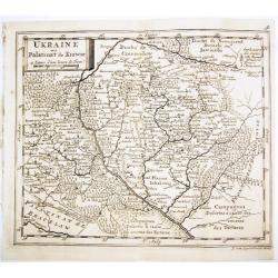
UKRAINE ou Palatinat de Kiowie.
A rare copper engraved map of the central Ukraine and the Kiev surrounding. From 'Theatre complet et particularise de la Guerre du Nort', La Haye ,1711.
Date: La Haye, 1711
Selling price: ????
Please login to see price!
Sold in 2021
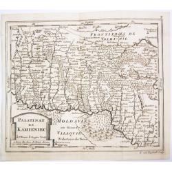
PALATINAT DE KAMIENIEC.
A rare copper engraved map of the former Polish Palatinate of Kamieniec in the south-western Ukraine. From 'Theatre complet et particularise de la Guerre du Nort', La Hay...
Date: La Haye, 1711
Selling price: ????
Please login to see price!
Sold in 2021
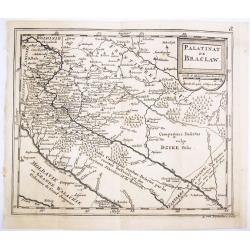
PALATINAT DE BRACLAW.
A rare copper engraved map of the old Polish Palatinate of Braclaw in the south-western Ukraine. From 'Theatre complet et particularise de la Guerre du Nort', La Haye , 1...
Date: La Haye, 1711
Selling price: ????
Please login to see price!
Sold in 2021
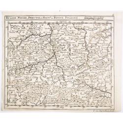
RUSSIE NOIRE, POKUTIE,et HAUTE ou PETITE POLOGNE.
A rare copper engraved map of the western Ukraine and southern Poland. From 'Theatre complet et particularise de la Guerre du Nort', La Haye , 1711.
Date: La Haye, 1711
Selling price: ????
Please login to see price!
Sold in 2021
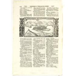
Chersonesus.
Town view of Sevastopol, set in a text page with Latin text. Taken from "Universus Terrarum Orbis", printed in Padua in 1713.
Date: Padua, Lasor a Varea, 1713
Selling price: ????
Please login to see price!
Sold in 2011
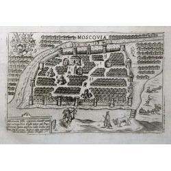
Moscovia.
An early plan of Moscow set on a page with latin text. Small but detailed view with many buildings, the city fortifications, and figures including a mounted archer. On th...
Date: Padua, 1713
Selling price: ????
Please login to see price!
Sold in 2016
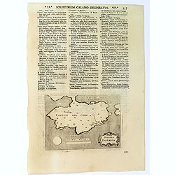
Piccola Tartaria.
A basic map of the Crimea, with little detail shown. Small strap-work cartouche, set in a text page with Latin text. Taken from "Universus Terrarum Orbis", prin...
Date: Padua, Lasor a Varea, 1713
Selling price: ????
Please login to see price!
Sold in 2016
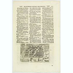
Moscovia / Moscovia Imperium.
An early plan of Moscow, set in text, first published ca.1600, with the buildings wonderfully shown in perspective. Based on the Braun & Hogenberg map, it is decorate...
Date: Padua, 1713
Selling price: ????
Please login to see price!
Sold in 2020
(LA MER NOIRE, Autrefois PONT-EUXIN, . . .)
Maps of the region Black sea, showing the cities of Constantinople, Heraclee, Kafa. From his 'Atlas Curieux'.Accomplanied by an engraved text sheet "Description de l...
Date: Paris, 1714
Selling price: ????
Please login to see price!
Sold in 2010
Zee en Landtogt door A. Jenkinson van Astracan Gedaan na Tartarien en terug tot in Moscow
A map of the lands around the Black Sea and the Caspian Sea, illustrating the travels of A. Jenkinson. Decorated with a nice title-cartouche.Although not renowned for the...
Date: Leiden, 1714
Selling price: ????
Please login to see price!
Sold in 2011
![[No title] La mer noire, autrefois Pont-Euxin. . .](/uploads/cache/32268-250x250.jpg)
[No title] La mer noire, autrefois Pont-Euxin. . .
Map of the Black sea, with the border countries of Turkey (in Asia), Romania, Bulgaria, Moldova, Ukraine and Russia with rivers and coastal towns shown. (Constantinople, ...
Date: Paris, 1714
Selling price: ????
Please login to see price!
Sold in 2020
Mingrelie autrefois Colchis, Pays baigné au Couchant par la MER NOIRE. . .
Uncommon and detailed map of the kingdom of Colchis, in the region of Mingrelia, north west Georgia, from Nouvelle atlas, très-exact et fort commode pour toutes sortes d...
Date: Leiden, 1714
Selling price: ????
Please login to see price!
Sold in 2014
Nouvelle Carte Des Etats Du Grand Duc De Moscovie En Europe.
A detailed map of the Northern and Southern parts of Russia in Europe. A nicely detailed copperplate engraving covering the region from Vibourg in the west, Astracan in t...
Date: Amsterdam, 1714
Selling price: ????
Please login to see price!
Sold in 2018
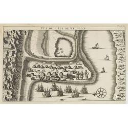
Vüe de l'Ile de Kilduyn.
A view of the Kilduyn Island on the Kola River in Russia. In upper right corner "To. 3. pa.24."The Kola River in the northern part of the Kola Peninsula...
Date: 1715
Selling price: ????
Please login to see price!
Sold in 2009
Russiae et Novae Zemblae Maritimae.
Splendid sea-chart of the Barents Sea coast from Murmansk to Novaya Zemlya. The chart is embellished with sailing ships, whaling scenes. In the upper right corner a title...
Date: Amsterdam, 1715
Selling price: ????
Please login to see price!
Sold in 2009
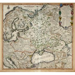
Generalis Totius Imperii Russorum Novissim Tabula
Map of the Russian Empire. With beautiful cartouche, ships and seamonsters.
Date: Nuremberg, 1716
Selling price: ????
Please login to see price!
Sold in 2008
To His Most Serene and August Majesty Peter Alexovitz Absolute Lord of Russia &c. This map of Moscovy, Poland, Little Tartary, and ye Black Sea &c. is most Humbly Dedicated by H. Moll Geographer
Magnificent large-scale, English map of Russia, Ukraine, Poland, Finland and the Baltic Countries and extending south to the Black Sea and the Balkans, with an ornate ded...
Date: London, 1716
Selling price: ????
Please login to see price!
Sold in 2015
La Russie Blanche ou Moscovie divisée. . .
Fine map of the European part of Russia with a decorative title and scale cartouche.Alexis-Hubert Jaillot (1632-1712), was a French cartographer. He joined the Sanson hei...
Date: Paris, 1717
Selling price: ????
Please login to see price!
Sold in 2011
La Russie Blanche ou Moscovie Divisee Suivant l'Estendue Des Royaumes Duches. . .
European Russia, including Ukraine. With ornamental title cartouche and scale cartouche in the upper corners. Russia, extending from the Baltic and Black Seas to Grande T...
Date: Paris, ca. 1685 - 1717
Selling price: ????
Please login to see price!
Sold in 2016
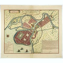
Plan De La Nouvelle Ville De Petersbourg.
The first printed city plan of St. Petersburg, created not long after the founding of the City by Czar Peter the Great. Shows St. Petersburg as it was planned to be built...
Date: Paris, 1717
Selling price: ????
Please login to see price!
Sold in 2019
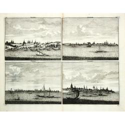
Niesna / Swyatski / Casan / Samara
Four views on one sheet of Russian towns.
Date: Amsterdam, 1718
Selling price: ????
Please login to see price!
Sold
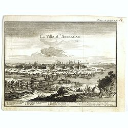
La ville d'Astracan.
Panoramic view of the town of Astracan, based on the observations of Jan Janszoon Struys. In lower part a numbered key (1-14) to the most important buildings.From "I...
Date: Amsterdam, ca. 1718
Selling price: ????
Please login to see price!
Sold in 2017
