Browse Listings in Europe > Russia / Baltic / Black Sea region > Ukraine / Black Sea
![[Taurica]](/uploads/cache/37038-250x250.jpg)
[Taurica]
In 1528 the Italian cartographer Benedetto Bordone (1460-1531) produced an atlas of islands. The interior of the island is depicted as mountainous with symbols for severa...
Date: Venice, 1534
Selling price: ????
Please login to see price!
Sold in 2023
![[Taurica chersoneso]](/uploads/cache/37105-250x250.jpg)
[Taurica chersoneso]
In 1528 the Italian cartographer Benedetto Bordone (1460-1531) produced an atlas of islands. An early, crude, but also fascinating small map depicting the region around C...
Date: Venice, c 1534
Selling price: ????
Please login to see price!
Sold in 2016
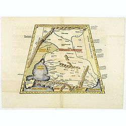
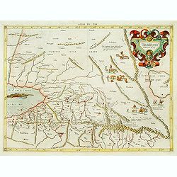
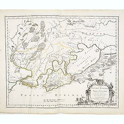
ASIAE TABULA secunda continet.
This is a Ptolemaic version of the Black Sea, Ukraine and Southern Russia areas extending to the Caspian Sea. The Crimean Penninsula is shown, lower left, and the Russian...
Date: Vienne, 1541
Selling price: ????
Please login to see price!
Sold in 2019
![[Map of Caspian Sea and Europe]](/uploads/cache/31512-250x250.jpg)
[Map of Caspian Sea and Europe]
Page with an early representation of the Caspian Sea and on verso a map of Europe. This text page with a fine wood block printed map is from the rare work "C. Iulii ...
Date: Basle, Michael Isengrin, 1544
Selling price: ????
Please login to see price!
Sold in 2011
![[Map of Ukrania]](/uploads/cache/31494-250x250.jpg)
[Map of Ukrania]
Page with an early representation of Ukrania with the Black Sea. This text page with a fine wood block printed map is from the rare work "C. Iulii Solini Polyhistor,...
Date: Basle, Michael Isengrin, 1544
Selling price: ????
Please login to see price!
Sold in 2011
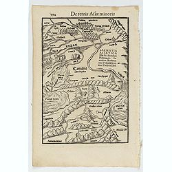
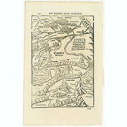
De terris Asiae minoris.
A woodblock printed map of the region between the Black Sea and the Caspian Sea with parts of Tartary and Kazakhstan, also neighboring Armenia in the south. From the 1552...
Date: Basel, 1552
Selling price: ????
Please login to see price!
Sold in 2022
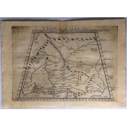
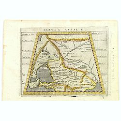
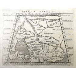
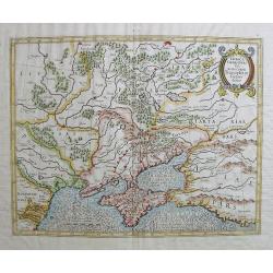
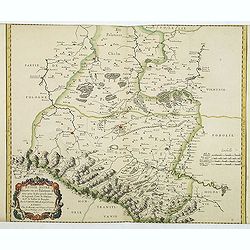
Tabula Asiae II.
A scarce map of the ancient region of Asiatic Sarmatia - now Southern Russia and part of Ukraine, around the Azov sea. Shows Armenia Maior, Iberia, Albania, Colchis, Port...
Date: Venice, 1574
Selling price: ????
Please login to see price!
Sold in 2017
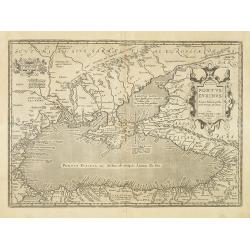
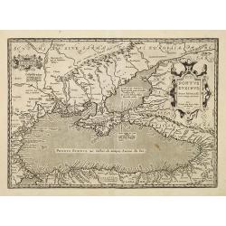
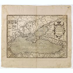
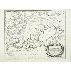
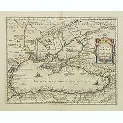
Pontus Euxinus Aequor Iafonio pulfatum remige premum.
Prepared by Ortelius after Mercator, and additional ancient sources as Plinius, Ovidius, Strabo, Apollonius, Procopius, and Apppianus.This map belongs to a series of hist...
Date: Antwerp, 1590
Selling price: ????
Please login to see price!
Sold in 2011
Pontus Euxinus Aequor Iafonio pulfatum remige premum.
Prepared by Ortelius after Mercator, and additional ancient sources as Plinius, Ovidius, Strabo, Apollonius, Procopius and Apppianus.This map belongs to a series of histo...
Date: Antwerp, 1590
Selling price: ????
Please login to see price!
Sold in 2010
De terris asiae minoris.
On verso a wood block printed map of the region between the Black Sea and the Caspian Sea with parts of Tartary and Kazakhstan, also the neighboring Armenia in the south....
Date: Basle, 1550-1590
Selling price: ????
Please login to see price!
Sold in 2013
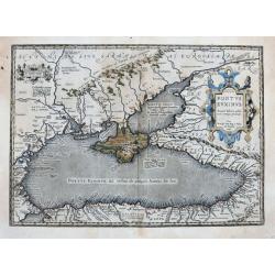
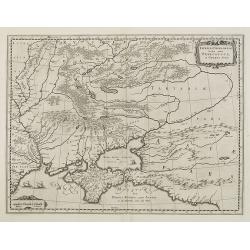
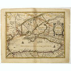
Pontus Euxinus Aequor Iafonio pulfatum remige premum.
Prepared by Ortelius after Mercator, and additional ancient sources as Plinius, Ovidius, Strabo, Apollonius, Procopius and Apianus.This map belongs to a series of histori...
Date: Antwerp, 1590
Selling price: ????
Please login to see price!
Sold in 2021
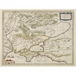
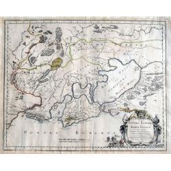
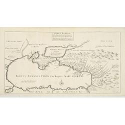
Pontus Euxinus Aequor Iafonio pulfatum remige premum.
An early map of the Black Sea, Sea of Azov, and its coasts which includes parts of Turkey, Armenia, Georgia, Russia, Ukraine, Crimea, Moldova, Romania, and Bulgaria. It s...
Date: Antwerp, 1592
Selling price: ????
Please login to see price!
Sold in 2020
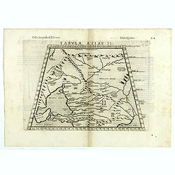
Tabula Asiae II.
A striking example of Magini's map of the Black Sea region, from the 1597 edition of Magini's 'Geographia', based upon the work of Claudius Ptolemy. Latin text and tables...
Date: Venice, 1597
Selling price: ????
Please login to see price!
Sold in 2016
Tabula Asiae II.
The third state of Ruscelli's map of part of the Ukraine and the region between the Black Sea and Caspian Sea extending south to include all of Armenia Maior and part of ...
Date: Venice, 1598
Selling price: ????
Please login to see price!
Sold in 2018
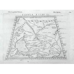
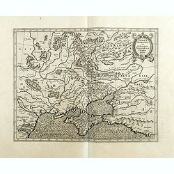
Tabula Asiae II
An interesting Ptolemaic map with trapezoidal projection. Shows the Caucasus region from the modern-day Crimea and Sea of Azov, to the mouth of the Volga River and the Ca...
Date: Venice, 1599
Selling price: ????
Please login to see price!
Sold in 2016
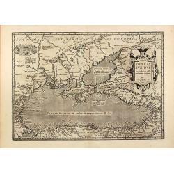
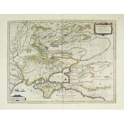
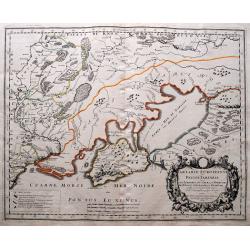
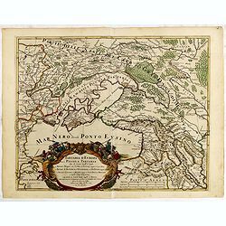
Pontus Euxinus
Detailed engraved map of the Black Sea by Abraham Ortelius. Covering the Black Sea with Ukraine, Crimea, and the surrounding countries. With two Renaissance cartouches. F...
Date: Antwerp, 1603
Selling price: ????
Please login to see price!
Sold in 2011
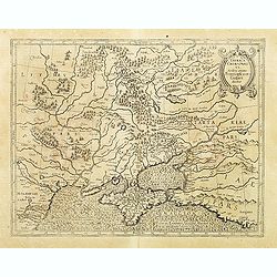
Taurica Chersonesus.
One of the earliest detailed maps of the Crime and Ukraine.
Date: Amsterdam, 1606
Selling price: ????
Please login to see price!
Sold
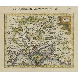
Taurica Cherso:nesus.
Map centered on Ukraine, from the first French-text edition of Jodocus Hondius\'\' Atlas Minor.Shortly after the publication of the big folio-atlases the need was apparen...
Date: Amsterdam, 1608
Selling price: ????
Please login to see price!
Sold in 2008
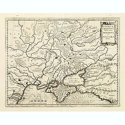
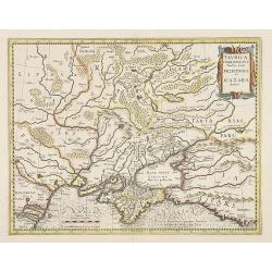
Taurica Chersonesus Nostra aetate Przecopsca et Gazara dicitur.
Mercator's fine map of the region north of the Black Sea encompassing the Crimea and the southern steppes of Ukraine. This map served as the basis of most other cartograp...
Date: Amsterdam, 1610
Selling price: ????
Please login to see price!
Sold in 2010
Asiae Tabula VII Continet Hyrcaniam, Margianam, Bactrianam, Sogdianam
Map of central Asia based upon Ptolemy's Atlas.
Date: Amsterdam, 1580-1612
Selling price: ????
Please login to see price!
Sold
Taurica Chersonesus.
One of the earliest detailed maps of the Crime and Ukraine.
Date: Amsterdam, 1613
Selling price: ????
Please login to see price!
Sold in 2010
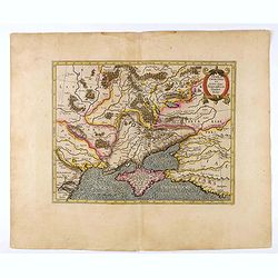
Tabula Asiae II.
A fine Ptolemaic map, probably from the Jansson/Magini atlas of 1617. It shows the Caucasus region with today's Armenia, Georgia, Turkey, Ukraine, Crimea, and the Sea of ...
Date: Amsterdam, 1617
Selling price: ????
Please login to see price!
Sold in 2018
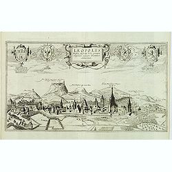
Leopolis Russiae Australis Urbs primaria emporiummercium Orientalium celeberrimum.
A of Lviv in Ukraine from the west.
Date: Cologne, 1618
Selling price: ????
Please login to see price!
Sold in 2012
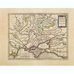
Taurica Chersones Nostra Aetate Przecopsca et Gazara
A decorative map and is one of the earliest maps of the Ukraine and Crimea displaying the coast of the black sea.
Date: Amsterdam, 1620
Selling price: ????
Please login to see price!
Sold in 2010
Taurica Chersonesus Nostra aetate Przecopsca et Gazara dicitur.
Mercator's fine map of the region north of the Black Sea encompassing the Crimea and the southern steppes of Ukraine. This map served as the basis of most other cartograp...
Date: Amsterdam, ca.1630
Selling price: ????
Please login to see price!
Sold in 2012
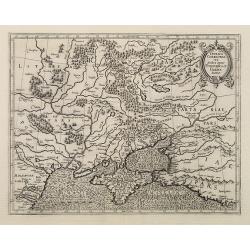
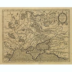
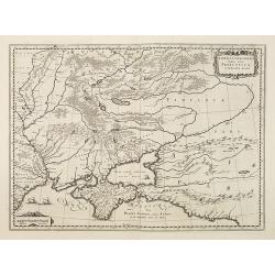
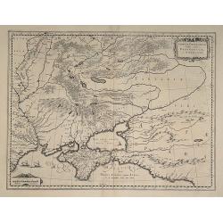
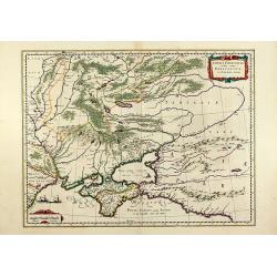
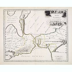
Tab. II. Asiae Sarmatiam Asiaticam repraesentans.
Ancient map covering the region north of the Black and Caspian Seas as far as the Hyperborie Montes. An illustration of the Alexandrii Columne is featured near the center...
Date: Amsterdam, 1630
Selling price: ????
Please login to see price!
Sold in 2015
Taurica Chersonesus.
One of the earliest detailed maps of the Crime and Ukraine.
Date: Amsterdam, ca. 1630
Selling price: ????
Please login to see price!
Sold in 2021
Taurica Chersonesus.
One of the earliest detailed maps of the Crime and Ukraine. Mercator's fine map of the region north of the Black sea encompasses the Crimea and the southern steppes of Uk...
Date: Amsterdam 1633
Selling price: ????
Please login to see price!
Sold in 2018
Taurica Chersonesus, Nostra aetate Przecopsca, et Gazara dicitur.
Part of Russia with in the north Smolensk and Moscow and in the south the Black Sea.
Date: Amsterdam, 1638
Selling price: ????
Please login to see price!
Sold in 2010
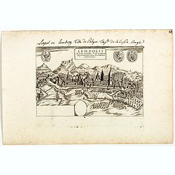
Leopolis Russiae Australis . . .
Extremely rare and detailed bird's-eye view of the town of Lviv by Giacomo Lauro (active about 1584-1637), taken from "Heroico Splendore delle Città del Mondo"...
Date: Rome, 1628 or 1639
Selling price: ????
Please login to see price!
Sold in 2019
Tavrica Chersonesva Mostra aetate Prezecopsca et Gazara dicitur
Nice map of the Ukraine with in the north Moscow. On verso Latin text ?Tavrica Chersonesus? F2 Urbes. Very slight discoloring on fold.
Date: c. 1640
Selling price: ????
Please login to see price!
Sold in 2008
Taurica Chersonesus, Nostra aetate Przecopsca et Gazara dicitur.
Old colored engraved map of the Ukraine with the Crimea peninsula by W. Blaeu. With two colored cartouches and three sailing ships. From "Atlas Major" around 16...
Date: Amsterdam, 1640
Selling price: ????
Please login to see price!
Sold in 2011
Taurica Chersonesus.
One of the earliest detailed maps of the Crimea and Ukraine between the northern coast of the Black Sea and Moscow in Russia.With the signature of Gerard Mercator in lowe...
Date: Amsterdam, 1639-1644
Selling price: ????
Please login to see price!
Sold in 2009
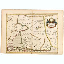
Taurica Chersonesus, Hodie Przecopsca, at Gazara dicitur.
From a French composite atlas.Read more about Dutch - French ties.[+]Detailed map of the Ukraine and surrounding regions between the northern coast of the Black Sea and M...
Date: Amsterdam, after 1644
Selling price: ????
Please login to see price!
Sold in 2016
Taurica Chersonesus.
One of the earliest detailed maps of the Crimea and Ukraine between the northern coast of the Black Sea and Moscow.With the signature of Gerard Mercator in lower left cor...
Date: Amsterdam, 1639-1644
Selling price: ????
Please login to see price!
Sold in 2016
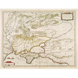
Taurica Chersonesus, Nostra aetate Prezecopsca, et Gazara dicitur.
Detailed map of the Ukraine, Russia with in the north Smolensk and Moscow and in the south the Black Sea. Shows ports, fortified cities and the mouths of the Danube. Mino...
Date: Amsterdam 1645
Selling price: ????
Please login to see price!
Sold
Taurica Chersonesus, Nostra aetate Przecopsca, et Gazara dicitur.
Part of Russia with in the north Smolensk and including Moscow and in the south the Black Sea.More about Willem Blaeu. [+]Taurica, Tauric Chersonese, and Taurida were nam...
Date: Amsterdam, 1645
Selling price: ????
Please login to see price!
Sold in 2011
Taurica Chersonesus, Nostra aetate Przecopsca, et Gazara dicitur.
Detailed map of the Ukraine, Russia with in the north Smolensk and Moscow and in the south the Black Sea. Shows ports, fortified cities and the mouths of the Danube. With...
Date: Amsterdam, 1645
Selling price: ????
Please login to see price!
Sold in 2016
Taurica Chersonesus, Nostra aetate Przecopsca, et Gazara dicitur.
Part of Russia with in the north Smolensk and including Moscow and in the south the Black Sea.
Date: Amsterdam, 1645
Selling price: ????
Please login to see price!
Sold in 2010
![[Astrakan to Parskylan]](/uploads/cache/28797-250x250.jpg)
[Astrakan to Parskylan]
Showing the region of the Cremea, from Astrakan to Parskylan.
Date: 1648
Selling price: ????
Please login to see price!
Sold in 2010
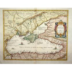
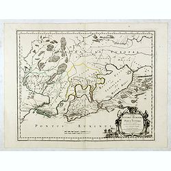
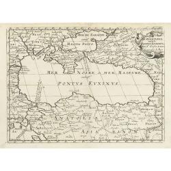
Pontus Euxinus.
Handsome depiction of the environs of the Black Sea in classical times filled with ancient place names and titled also in Greek. The cartography is based on Ortelius' fir...
Date: Amsterdam, 1650
Selling price: ????
Please login to see price!
Sold in 2015
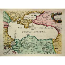
Mer Noire ou Mer Maievre.
Nicolas Sanson (1600-67), ' father of the French cartography' and founder of the Sanson firm. Atlas ' Cartes générales de toutes les parties du Monde', 1658-70 and a po...
Date: Paris, c. 1652
Selling price: ????
Please login to see price!
Sold
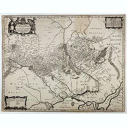
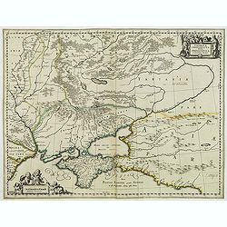
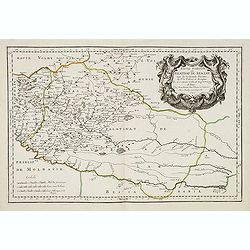
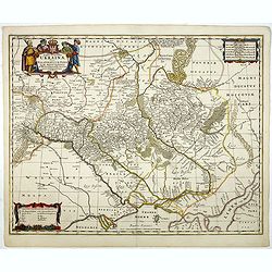
Typus Generalis Ukrainae sive Palatinatuum Podoliae, Kioviensis et Braczlaviensis terras nova delineatione exhibens. . .
A key map engraved by Johannes Janssonius in about 1656 and based on Guillaume La Vasseur de Beauplan's map of the region published in "Description d'Ukraine". ...
Date: Amsterdam, ca. 1657
Selling price: ????
Please login to see price!
Sold in 2026
Taurica Chersonesus.
A copper engraved map of the central Ukraine from the "Atlas Minor" (Gerhard Mercator / Jodocus Hondius). Extends from Cherkassy to Crimea and the Sea of Azov. ...
Date: Amsterdam, ca. 1609 -1660
Selling price: ????
Please login to see price!
Sold in 2018
Ukrainae pars quae Kiovia Palatinatus.
This is a scarce Joan Blaeu first edition of the map of the Kiev region of Ukraine and vicinity. Signature of Joan Blaeu in the lower part of the map. This map was origin...
Date: Amsterdam, ca. 1660
Selling price: ????
Please login to see price!
Sold
Tartarie Europeenne ou Petite Tartari où sont Les Tartares, Du Crim, ou de Perecop, De Nogais, D'Oczacow, et de Budziak . . .1665
Detailed map of Ukraine, the Crimea and the northern part of the Caspian Sea. Numerous place-names of counties, cities, towns, physical features.
Date: Paris, 1665
Selling price: ????
Please login to see price!
Sold in 2011
RUSSIE NOIRE. divisée en ses Palatinats. &c. tirée pour la plus grande partie de la grande Carte de l'Ukraine, du Sr. le Va??eur de Beauplan. Par le Sr SANSON d'Abbeville Geogrr ordre du Roy.
First state. Map of the Ukraine and centered on Lvov (Lemberg). The map was based on the map of Ukraine by Beauplan and Radziwill's map of Lithuania.
Date: Paris, 1665
Selling price: ????
Please login to see price!
Sold in 2011

Basse Volhynie ou palatinat de Kiow, tiré entièrement de la grande Ukraine du Sieur le Vasseur de Beauplan / par le Sr. . .
Scarce and fine map after Guillaume Le Vasseur de Beauplan (c. 1600 — December 6 1673), who was a French cartographer, engineer and architect. Beauplan served as artill...
Date: Paris, 1665
Selling price: ????
Please login to see price!
Sold in 2013
Basse podolie, Palatinat de Braclaw tiré de la grande Ukraine du Sieur le Vasseur de Beauplan / par le Sr. . .
Scarce and fine map of Ukraine after Guillaume Le Vasseur de Beauplan (c. 1600 — December 6 1673), who was a French cartographer, engineer and architect. Beauplan serve...
Date: Paris, 1665
Selling price: ????
Please login to see price!
Sold in 2013
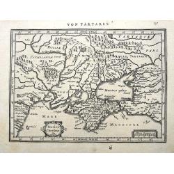
Cimmeria quae postea Scythia Europaea seu Parua Scythia / ex conatibus geographicis Gulielmi Sanson. . .
Ancient map of the region north of the Black Sea. Showing mountains, forests and cities and locates historical regions. The title cartouche includes a small vignette feat...
Date: Paris, 1665
Selling price: ????
Please login to see price!
Sold in 2013
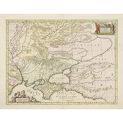
Bosphorus Cimmerius et regnum bosphoranum / ex collectionibus. . .
Historical map illustrating the Kerch Strait between the Sea of Azov in southern Ukraine and the Black Sea and not the Bosporus as indicated by the title. The map is fill...
Date: Paris, 1665
Selling price: ????
Please login to see price!
Sold in 2013
Tartarie Europeenne ou Petite Tartari ou sont Les Tartares, Du Crim, ou de Perecop; De Nogais, D'Oczacow, et de Budziak...
Detailed map of Ukraine, the Crimea, Sea of Azov, and the northern part of the Black Sea. Includes the cities of Kiev, Smolensk, Ryazan, Belgorod, and many more. With i...
Date: Paris, 1665
Selling price: ????
Please login to see price!
Sold in 2014
Cimmeria quae postea Scythia Europaea seu Parua Scythia / ex conatibus geographicis Gulielmi Sanson. . .
Ancient map of the region north of the Black Sea. Showing mountains, forests and cities and locates historical regions. The title cartouche includes a small vignette feat...
Date: Paris, 1665
Selling price: ????
Please login to see price!
Sold in 2017
Cimmeria quae Postea Scythia Europaea Seu Parua Scythia. . .
A great map of Crimea, with parts of the Ukraine, and Russia. The map shows mountains, forests, regions and cities with their historical names. A strap work title cartouc...
Date: Paris, 1665
Selling price: ????
Please login to see price!
Sold in 2020
Haute Podolie ou palatinat de Kamieniec tirée entierement de la Gr. Vkraine . . .
Two maps on one sheet covering parts of Romania and Ukrania. Prepared by Guillaume Le Vasseur de Beauplan (1600-1685) , who was a French cartographer, engineer and archit...
Date: Paris, 1665
Selling price: ????
Please login to see price!
Sold in 2019
Basse Podolie, Palatinat de Braclaw tiré de la grande Ukraine du Sieur le Vasseur de Beauplan / par le Sr. . .
Scarce and fine map of Ukraine after Guillaume Le Vasseur de Beauplan (c. 1600 — December 6 1673), who was a French cartographer, engineer and architect. Beauplan serve...
Date: Paris, 1665
Selling price: ????
Please login to see price!
Sold in 2020
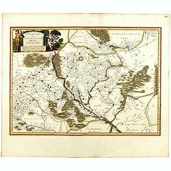
![RUSSIE NOIRE divisee en ses Palatinats &c. [Lviv]](/uploads/cache/83216-250x250.jpg)
RUSSIE NOIRE divisee en ses Palatinats &c. [Lviv]
A rare map of the so-called 'Black Russia' region in south-western Ukraine. With a cartouche and with mountains, forests and many names of cities, rivers and villages dep...
Date: Paris, 1665
Selling price: ????
Please login to see price!
Sold in 2020
Basse Volhynie ou palatinat de Kiow, tiré entièrement de la grande Ukraine du Sieur le Vasseur de Beauplan / par le Sr. . .
Scarce and fine map after Guillaume Le Vasseur de Beauplan (c. 1600 — December 6 1673), who was a French cartographer, engineer and architect. Beauplan served as artill...
Date: Paris, 1665
Selling price: ????
Please login to see price!
Sold in 2020
Haute Volhynie ou palatinat de Lusuc, tiré entièrement de la grande Ukraine du Sieur le Vasseur de Beauplan . . .
Scarce and fine map after Guillaume Le Vasseur de Beauplan (c. 1600 — December 6 1673), who was a French cartographer, engineer and architect. Beauplan served as artill...
Date: Paris, 1665
Selling price: ????
Please login to see price!
Sold in 2020
Haute Podolie ou palatinat de Kamieniec, tirée entièrement de la Gr. Ukraine du Sr Le Vaaseur de Beauplan / par le Sr Sanson. . .
Two maps on one sheet covering parts of Romania and Ukraine. Prepared by Guillaume Le Vasseur de Beauplan (1600-1685) , who was a French cartographer, engineer and archit...
Date: Paris, 1665
Selling price: ????
Please login to see price!
Sold in 2020
Basse Podolie, Palatinat de Braclaw tiré de la grande Ukraine du Sieur le Vasseur de Beauplan / par le Sr. . .
Scarce and fine map of Ukraine after Guillaume Le Vasseur de Beauplan (c. 1600 — December 6 1673), who was a French cartographer, engineer and architect. Beauplan serve...
Date: Paris, 1665
Selling price: ????
Please login to see price!
Sold in 2025
Taurica Chersonesus Nostra aetate Przecopsca et Gazara dicitur.
A map showing the area between the northern coast of the Black Sea, the present day Ukraine and part of Russia, with the Crimean including the mouth of the Danube River a...
Date: Amsterdam, 1662-1665
Selling price: ????
Please login to see price!
Sold in 2022
Illyricum Orientis In quo Partes II. Moesia et Thracia. Provinciae XI.
Attractive historical map of the area west of the Black Sea, today's Bulgaria, Rumania, etc. Based on the cartography of Nicolas Sanson and published by P.Mariette. With ...
Date: Paris, 1666
Selling price: ????
Please login to see price!
Sold in 2020
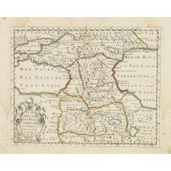
Turcomanie Georgie Commanie. . .
Attractive general map of Caucasus Mountains, Armenia and Georgia prepared by N.Sanson and published by Pierre Mariette.Published in an early edition of the small Sanson ...
Date: Paris, P. Mariette, 1667
Selling price: ????
Please login to see price!
Sold in 2008
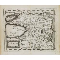
Géorgie.
Uncommon miniature map of Georgia from Pierre Duval's La Geographie Universeille dated 1676. Following his Cartes de geographie in 1657, Pierre Duval published this small...
Date: Paris, 1676
Selling price: ????
Please login to see price!
Sold in 2008
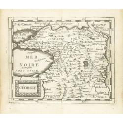
Géorgie.
Scarce miniature map of Georgia from Pierre Duval's La Geographie Universeille dated 1676. Following his Cartes de geographie in 1657, Pierre Duval published this smaller...
Date: Paris, 1676
Selling price: ????
Please login to see price!
Sold in 2015
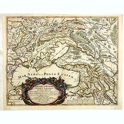
De Zwartezee, eertyts Pontus Euxinus . . .
Map encompassing part of the Near East and the area comprehended between the Black Sea and the Caspian Sea.Prepared by N.Sanson.
Date: Amsterdam, Utrecht, 1680
Selling price: ????
Please login to see price!
Sold in 2010
Nouvelle Carte de la Mer Noire et du Canal de Constantinople.
Decorative and uncommon map the Black Sea region. In upper left hand corner an inset map (200x280) of the Bosporus including Istanbul.
Date: Amsterdam, 1680
Selling price: ????
Please login to see price!
Sold in 2011
Typus Generalis Ukrainae sive Palatinatuum Podoliae, Kioviensis et Braczlaviensis terras nova delineatione exhibens. . .
Key map based on Guillaume La Vasseur de Beauplan's map of the region published in "Description d'Ukraine". The work described Ukraine as several provinces of t...
Date: Oxford, 1680
Selling price: ????
Please login to see price!
Sold in 2014
Taurica Chersonesus Hodie Przecopsca et Gazara dicitur. . .
Map shows the Ukraine with the island of Crimea.
Date: London,1680
Selling price: ????
Please login to see price!
Sold in 2014
Typus Generalis Ukrainae sive Palatinatuum Podoliae, Kioviensis et Braczlaviensis terras nova delineatione exhibens. . .
Key map based on Guillaume La Vasseur de Beauplan's map of the region published in "Description d'Ukraine". The work described Ukraine as several provinces of t...
Date: Nuremberg, ca. 1680
Selling price: ????
Please login to see price!
Sold in 2016
Typus Generalis Ukrainae sive Palatinatuum Podoliae, Kioviensis et Braczlaviensis terras nova delineatione exhibens. . .
Keymap based on Guillaume La Vasseur de Beauplan's map of the region published in "Description d'Ukraine." The work described Ukraine as several provinces of th...
Date: Oxford, 1680
Selling price: ????
Please login to see price!
Sold in 2020
Taurica Chersonesus, Hodie Przecopsca, at Gazara dicitur.
Detailed map of the Ukraine and surrounding regions between the northern coast of the Black Sea and Moscow. Shows ports, fortified cities and the mouths of the Danube. Tw...
Date: Oxford, 1681
Selling price: ????
Please login to see price!
Sold in 2013
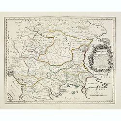
Die Caspische oder Hyrcanische See.
Strikingly engraved and attractive map of the Caspian Sea, showing major towns, ports, etc. Large decorative cartouche and compass rose. The engraving is neatly executed,...
Date: Nüremberg, Johann Hoffmanns, 1681
Selling price: ????
Please login to see price!
Sold in 2019
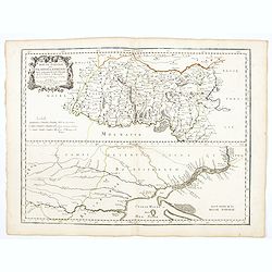
Tartaria D Europa ouero Piccola Tartaria divisa da Giacomo Cantelli da Vignola ne Tartari Nogai e del Crim, o di Precop . . .
Rare map of the Ukraine, Georgia, Muscovy, Southeastern Poland / Lithuania and the Black Sea. With an ornate allegorical cartouche.The cartographer of this map is Giacomo...
Date: Rome, 1683
Selling price: ????
Please login to see price!
Sold in 2022
Pontus Euxinus Aequor Iafonio pulfatum remige premum.
Prepared by Ortelius after Mercator, and additional ancient sources as Plinius, Ovidius, Strabo, Apollonius, Procopius and Apianus.This map belongs to a series of histori...
Date: Amsterdam, 1652-1684
Selling price: ????
Please login to see price!
Sold in 2011
Tartaria D Europa ouero Piccola Tartaria divisa da Giacomo Cantelli da Vignola ne Tartari Nogai e del Crim, o di Precop . . . ne Tartari di Budziack, D'Oczackow, e di Dobrus . . .Tartari Circassi . . .
Engraved by Vin Mariotti. Giacomo Rossi's fine late 17th century map of the Ukraine, Georgia, Muscovy, Southeastern Poland / Lithuania and the Black Sea. Issued in Il Mer...
Date: Rome, 1684
Selling price: ????
Please login to see price!
Sold in 2015
Pontus Euxinus Aequor Iafonio pulfatum remige premum.
Prepared by Ortelius after Mercator, and additional ancient sources as Plinius, Ovidius, Strabo, Apollonius, Procopius and Apianus.This map belongs to a series of histori...
Date: Amsterdam, 1652-1684
Selling price: ????
Please login to see price!
Sold in 2019
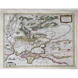
Ponti euxini cum regionibus versus septentrionem et orientem adjacentibus nova tabula.
A rare map of the Black Sea area from the travels of Sir Joan Chardin ( 1643-1713.) into Persia and the East Indies. See Copac . John Chardin (1643-1712) was the son of a...
Date: London, Moses Pitt, 1686
Selling price: ????
Please login to see price!
Sold in 2010
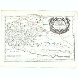
Descritione delli principati della Moldavia e Valachia / tolta da Giacomo Cantelli da Vignola.
Scarce map of the region between the Danube, Nistru, and Dnieper Rivers along the Black Sea - present-day Ukraine and Romania. Excellent detail throughout. Large and deco...
Date: Rome, 1686
Selling price: ????
Please login to see price!
Sold in 2018
