Browse Listings in Europe
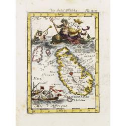
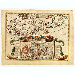
Isle de Malthe.
A charming late 17th century French map of Malta and Gozo with a large pictorial cartouche depicting Neptune and a merman, a nautical sailing ship scene across the bottom...
Date: Franckfurt 1684
Selling price: ????
Please login to see price!
Sold
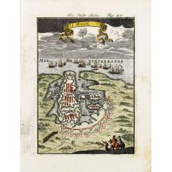
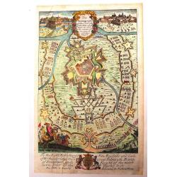
Malte.
A charming late 17th century French plan of La Valletta. With a ribbon style title cartouche and a nautical sailing ship scene across the top.By Allain Manneson Mallet (1...
Date: Franckfurt 1684
Selling price: ????
Please login to see price!
Sold
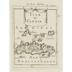
Isle de Candie.
A charming late 17th century French map of Crete and surrounding islands.By Allain Manneson Mallet (1630-1706), a well traveled military engineer and geographer who worke...
Date: Frankfurt, 1684
Selling price: ????
Please login to see price!
Sold in 2009
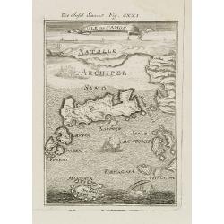
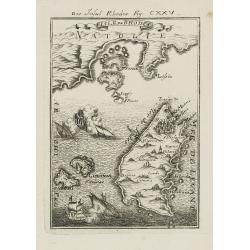
Isle de Samos.
A charming late 17th century map of the Samos Island. Samos is a Greek island in the North Aegean sea, south of Chios, north of Patmos and the Dodecanese, and off the Ion...
Date: Frankfurt, 1684
Selling price: ????
Please login to see price!
Sold in 2010
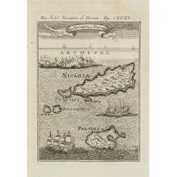
I. de Nicaria et Patmos.
A charming late 17th century map of the Island of Nicaria and Patmos. Located on the eastern borderline of the Aegean Sea, Patmos is the northernmost island of the Dodeca...
Date: Frankfurt, 1684
Selling price: ????
Please login to see price!
Sold in 2011
Rhodes.
A charming late 17th century map of the city of Rhodes. By Allain Manneson Mallet (1630-1706), a well traveled military engineer and geographer who worked in 17th century...
Date: Frankfurt, 1684
Selling price: ????
Please login to see price!
Sold in 2008
Isles de Rhodes.
A charming late 17th century map of the Islands of Rhodes. By Allain Manneson Mallet (1630-1706), a well traveled military engineer and geographer who worked in 17th cent...
Date: Frankfurt, 1684
Selling price: ????
Please login to see price!
Sold in 2009
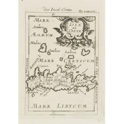
Isle de Crete.
A charming late 17th century map of the Island of Crete. By Allain Manneson Mallet (1630-1706), a well traveled military engineer and geographer who worked in 17th centur...
Date: Frankfurt, 1684
Selling price: ????
Please login to see price!
Sold in 2008
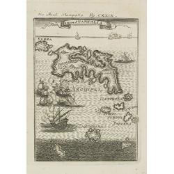
Isle de Stampalia.
A charming late 17th century map of the Stampalia Island. Stampalia is a Greek island which belongs to the Dodecanese, an island group of twelve major islands in the sout...
Date: Frankfurt, 1684
Selling price: ????
Please login to see price!
Sold in 2011
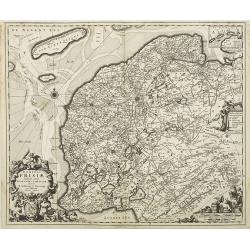
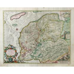
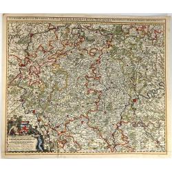
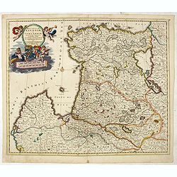
Novissima Comitatus Zutphaniae, Totiusque Fluminis Insulae Descriptio, ex Officina Nicolai Visscher.
Map of the province of Gelderland in the Netherlands. Taken from the atlas Germania Inferior, sive XVII Provinciarum Geographicae generales ut et particulares tabulae. Ka...
Date: Amsterdam, 1684
Selling price: ????
Please login to see price!
Sold in 2009
Ducatus Geldria et Zutphania Comitatus.
Map of Gelderland. West to the top. Taken from the atlas Germania Inferior, sive XVII Provinciarum Geographicae generales ut et particulares tabulae. Kaert-Boeck van de X...
Date: Amsterdam, 1684
Selling price: ????
Please login to see price!
Sold in 2009
Comitatus Hollandiae Tabula Pluribus Locis Recens Emendata.
Third state of 5) of this popular map of Holland, copied by F. de Wit, J. Danckerts and C. Allard and P. Schenk up to late in the 18th century. Bottom left corner an inse...
Date: Amsterdam, 1684
Selling price: ????
Please login to see price!
Sold in 2010
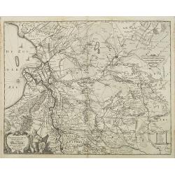
Transisalania Provincia vulgo Over-Yssel. Auctor. N. ten-Have.
Map of central part of the Netherlands with relief shown pictorially. With a decorative cartouche, showing a fisherman, typical for Claes Jansz. Visscher's maps. Prepared...
Date: Amsterdam, 1684
Selling price: ????
Please login to see price!
Sold in 2009
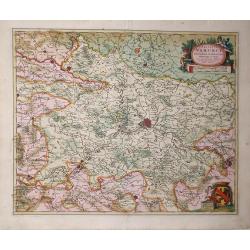
Limburgi Ducatus et Comitatus Valckenburgi Nova Descriptio Per N. Visscher.
The map describes the southern part of Limburg and reaches into Belgium (Liege, Verviers) and Germany (Aachen). The map has two decorative cartouches, etched by Mr. Romey...
Date: Amsterdam, 1684
Selling price: ????
Please login to see price!
Sold in 2018
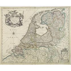
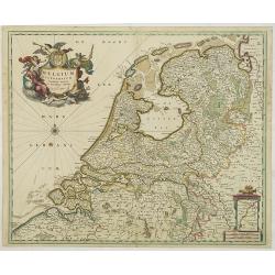
Belgium Foederatum emmendatè auctum et novissimè editum per Nicolaum Visscher.
A well detailed map of the present day Netherlands. The most southern part of Limburg in an inset, lower right corner. Taken from the atlas Germania Inferior, sive XVII P...
Date: Amsterdam, 1684
Selling price: ????
Please login to see price!
Sold in 2013
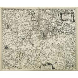
Mechlinia Dominium et Aerschot Ducatus Auctore Nicolao Visscher.
Fine decorative map of part of Belgium including the cities of Antwerp, Mechelen, Brussels, Leuven and Tienen. Taken from the atlas Germania Inferior, sive XVII Provincia...
Date: Amsterdam, 1684
Selling price: ????
Please login to see price!
Sold in 2015
Dominii Frisae Tabula, inter Flevumrt Lavicam, Auctore B. Schotano à Sterringa. Ex Officina Nicolai Visscher.
Map of the provinces Friesland. This map was prepared by B.Schotanus à Steringa. Taken from the atlas Germania Inferior, sive XVII Provinciarum Geographicae generales ut...
Date: Amsterdam, 1684
Selling price: ????
Please login to see price!
Sold in 2010
Belgium Foederatum emmendatè auctum et novissimè editum per Nicolaum Visscher.
A well detailed map of the present day Netherlands. The most southern part of Limburg in an inset, lower right corner. Taken from the atlas Germania Inferior, sive XVII P...
Date: Amsterdam, 1684
Selling price: ????
Please login to see price!
Sold in 2017
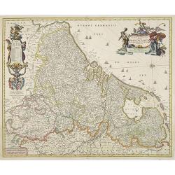
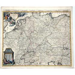
Novissima et accuratissima XVII Provinciarum Germaniae Inferior Delineatio, Ex Officina Nicolai Visscher.
Map of Belgium, the Netherlands and Luxembourg with a decorative title cartouche and cartouche of explanations and a dedication to Johan Munter. North orientated to the r...
Date: Amsterdam, 1684
Selling price: ????
Please login to see price!
Sold in 2009
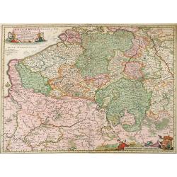
Belgii Regii Tabula, in qua omnes Provincia ab Hispanis ad Annum 1684 possessae, nec nontam a Rege Galliea quam Batavis acquifitae. . .
Beautifully colored map of present day Belgium, northern France, Luxembourg and the Netherlands from Visscher's Germania Inferior. Paris and Luxembourg are shown in the s...
Date: Amsterdam, 1677-1684
Selling price: ????
Please login to see price!
Sold in 2010
Dominii Frisia Tabula, inter Flevum et Lavicam.
Map of Friesland, a northern province of the Netherlands. The major cities of Friesland, such as Franeker, Leeuwarden and Sneek. The coat of arms of Friesland is depicted...
Date: Amsterdam, 1677-1684
Selling price: ????
Please login to see price!
Sold in 2010
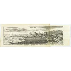
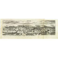
Ofen v. Pest.
Panoramic view of Ofen v. Pest (Budapest). Published in "Der Donau-Strand Mit allen seinen Ein- und Zuflüssen. . .".Published by Jacob Sandrart.
Date: Nuremberg, Jacob Sandrart, 1684
Selling price: ????
Please login to see price!
Sold in 2020
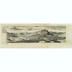
Gran.
Panoramic view of Gran (Esztergom). Published in "Der Donau-Strand Mit allen seinen Ein- und Zuflüssen. . ."Published by Jacob Sandrart.
Date: Nuremberg, Jacob Sandrart, 1684
Selling price: ????
Please login to see price!
Sold
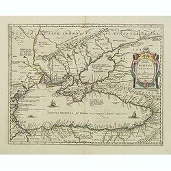
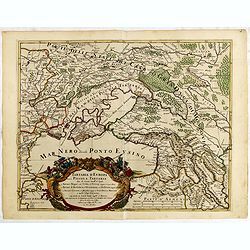
Pontus Euxinus Aequor Iafonio pulfatum remige premum.
Prepared by Ortelius after Mercator, and additional ancient sources as Plinius, Ovidius, Strabo, Apollonius, Procopius and Apianus.This map belongs to a series of histori...
Date: Amsterdam, 1652-1684
Selling price: ????
Please login to see price!
Sold in 2011
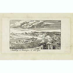
Alt Ofen. (Ó-Buda)
Panoramic view of Alt Ofen (Budapest). Published in "Der Donau-Strand Mit allen seinen Ein- und Zuflüssen. . .". Published by Jacob Sandrart.
Date: Nuremberg, Jacob Sandrart, 1684
Selling price: ????
Please login to see price!
Sold in 2020
Hand-vesten, Privilegien, Octroyen, Costumen en Willekeuren der Stad Amstelredam.
Very rare work on Amsterdam. With one page-sized map of the area around Amsterdam, and three (two double-page) scarce town plans. Folio, 1208 pages, two titles, plus regi...
Date: Amsterdam, 1662-1684
Selling price: ????
Please login to see price!
Sold in 2020
Novissima Comitatus Zutphaniae, Totiusque Fluminis Insulae Descriptio.
Map of the province of Gelderland in the Netherlands.Taken from the atlas Germania Inferior, sive XVII Provinciarum Geographicae generales ut et particulares tabulae. Kae...
Date: Amsterdam, 1684
Selling price: ????
Please login to see price!
Sold in 2014
Dalmatia Istria Bosnia Servia Croatia e parte di Schiavonia...
Giacomo Rossi's fine late 17th century map of Dalmatia, with cartouches for the title and dedication. Engraved by Francesco Donia after Vignola. Issued in Il Mercurio geo...
Date: Rome, 1684
Selling price: ????
Please login to see price!
Sold in 2015
Tartaria D Europa ouero Piccola Tartaria divisa da Giacomo Cantelli da Vignola ne Tartari Nogai e del Crim, o di Precop . . . ne Tartari di Budziack, D'Oczackow, e di Dobrus . . .Tartari Circassi . . .
Engraved by Vin Mariotti. Giacomo Rossi's fine late 17th century map of the Ukraine, Georgia, Muscovy, Southeastern Poland / Lithuania and the Black Sea. Issued in Il Mer...
Date: Rome, 1684
Selling price: ????
Please login to see price!
Sold in 2015
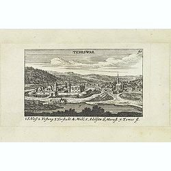
Temeswar. (Timisoara)
View of TimiSoara is a city in the Banat region of western Romania. It is the capital of TimiS County.
Date: Nuremberg, Jacob Sandrart, 1684
Selling price: ????
Please login to see price!
Sold in 2018
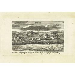
Tokay. (Tokaj)
Panoramic view of Tokaj, the center of the famous Tokaj-Hegyalja wine district where the world-famous Tokaji wine is produced Published in "Der Donau-Strand mit alle...
Date: Nuremberg, Jacob Sandrart, 1684
Selling price: ????
Please login to see price!
Sold in 2015
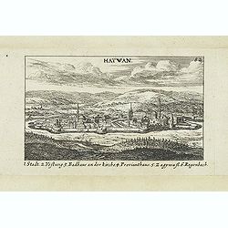
Hatwan.
Panoramic view of Hatvan in Hungary Published in "Der Donau-Strand Mit allen seinen Ein- und Zuflüssen. . .". Published by Jacob Sandrart.
Date: Nuremberg, Jacob Sandrart, 1684
Selling price: ????
Please login to see price!
Sold in 2020
Wardein.
Panoramic view of Grosswardein or NagyváradWardein (Oradea), in northwest Romania near the Hungarian border. Published in "Der Donau-Strand Mit allen seinen Ein- un...
Date: Nuremberg, Jacob Sandrart, 1684
Selling price: ????
Please login to see price!
Sold in 2022
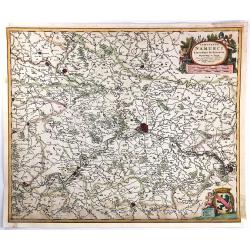
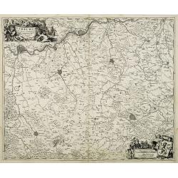
Comitatus Namurci Emendata Delineatio, Nuperrimè in lucem edita, per Nicolaum Visscher.
A detailed engraved map of the Belgian province of Namur (Namen), showing some cities including; Namur, Dinant & Charleroi. From the atlas “Germania Inferior, sive ...
Date: Amsterdam, 1684
Selling price: ????
Please login to see price!
Sold in 2016
Ungaria Orientale. . .
Rossi's map of Hungary, based upon Sanson's map, but with revised Italian nomenclature. The engraver was Francesco Donia.In lower right corner a dedicational cartouche. T...
Date: Rome, 1684
Selling price: ????
Please login to see price!
Sold in 2016
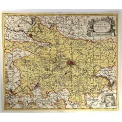
Comitatus Namurci Emendata Delineatio.
A fine copperplate map of the Namur region of Belgium, with the city of Namur at the center. Two large cartouches feature three putti making weapons, wearing armour and s...
Date: Amsterdam, 1684
Selling price: ????
Please login to see price!
Sold in 2016
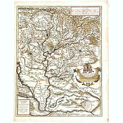
Luxembergensis Ducatus. Tam in Ejusdem Minores Quam Principales Ditiones Peraccurate Distinctus.
A strikingly decorative map of Luxemburg by Nicholas Visscher II. Taken from the his atlas “Germania Inferior, sive XVII Provinciarum Geographicae generales ut et parti...
Date: Amsterdam, 1684
Selling price: ????
Please login to see price!
Sold in 2016
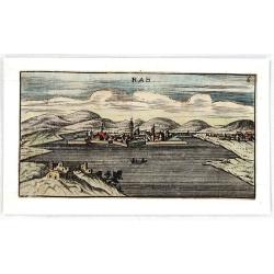
RAB.
Striking and highly decorative unusual miniature copper engraved panoramic view of Raab or Gyor, the Hungarian town on the Danube.Published in "Der Donau-Strand Mit ...
Date: Nuremberg, 1684
Selling price: ????
Please login to see price!
Sold in 2018
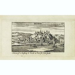
Belgrad.
Panoramic of Belgrade. Belgrade is the capital and largest city of Serbia. The city lies at the confluence of the Sava and Danube rivers, where the Pannonian Plain meets...
Date: Nuremberg, Jacob Sandrart, 1684
Selling price: ????
Please login to see price!
Sold in 2019
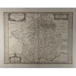
Gallia Vetus ad Julij Caesaris Commentaria.
A striking, detailed, copper engraved map of Gallia or Ancient France at the time of Julius Caesar. It is based on information from Caesar's "De Bello Gallico"....
Date: Amsterdam, 1684
Selling price: ????
Please login to see price!
Sold in 2019
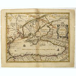
Pontus Euxinus Aequor Iafonio pulfatum remige premum.
Prepared by Ortelius after Mercator, and additional ancient sources as Plinius, Ovidius, Strabo, Apollonius, Procopius and Apianus.This map belongs to a series of histori...
Date: Amsterdam, 1652-1684
Selling price: ????
Please login to see price!
Sold in 2019
Ducatuum Lovoniae et Curlandiae Novissima Tabula in Quibus sunt Estonia Litlandia et Alir Minorus Provincae Per Iustum Danckerts Amstelodami cum Privilegio Ord: Hollandiae et West-Friesiae.
A rare and decorative map of Estonia, part of Latvia, Lithuania and Russia with a very beautiful cartouche of 2 putti carrying the title and 2 putti supporting 2 coat-of-...
Date: Amsterdam, 1684
Selling price: ????
Please login to see price!
Sold in 2021
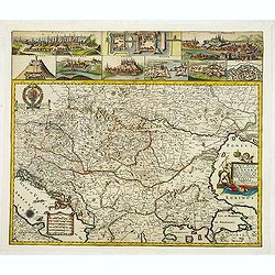
L'Empire D'Allemagne Divise En Tous Se Estats al Usage de Monseigneur le Duc De Bourgogne...
Rare map of the German Empire, which appeared in Jaillot's rare atlas dedicated to the Duke of Bourgogne and in later composite atlases. Two elaborate cartouches, includi...
Date: Paris, 1684
Selling price: ????
Please login to see price!
Sold in 2021
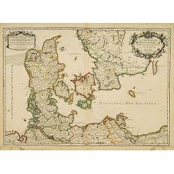
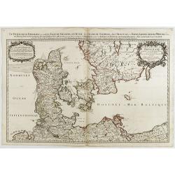
Le Royaume de Danmark subdivisé en ses Principales Provinces..
A decorative map of Denmark prepared by N.Sanson and published by Hubert Jaillot.
Date: Paris 1685
Selling price: ????
Please login to see price!
Sold
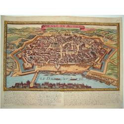
Vienne en Austriche
A scarce, uncommon bird's-eye view of the fortified city of Vienna and surrounding area. Superb detail of streets and individual buildings. Fortifications include walls a...
Date: Paris, ca. 1685
Selling price: ????
Please login to see price!
Sold
Nieuwe Pascaart waar in vertoont wert de Baij van Cadix In't groot.
An important sea-chart of the coast and island of Cadiz. With plate number 30 in lower right corner. Large title cartouche, with title in Dutch and French and a dedicatio...
Date: Amsterdam, 1685
Selling price: ????
Please login to see price!
Sold
Comitatus Namurci Emendata Delineatio Nuperrine in Lucem.
Map by Nicholas Visscher of the area around the Belgium city of Namur from Philipville to Huy and Charlemont. This map includes major cities such as Buillon, Fontaine and...
Date: Amsterdam, 1685
Selling price: ????
Please login to see price!
Sold in 2010
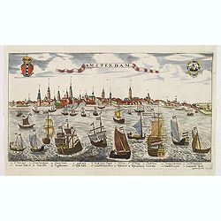
Amsterdam.
A rare panoramic view of the city of Amsterdam from 't IJ, with keys numbered from 1-21 to the principal buildings. A very decorative print with extensive shipping. Etchi...
Date: Augsburg, ca. 1685
Selling price: ????
Please login to see price!
Sold in 2012
Le Royaume de Danmark..
A decorative map of Denmark prepared by N.Sanson and published by Hubert Jaillot.
Date: Paris, 1685
Selling price: ????
Please login to see price!
Sold in 2014
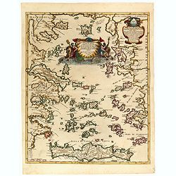
Arcipelago Mar Egeo con le coste del medesimo...
Giacomo Rossi's fine late 17th century map of the Greek Islands. Issued in Il Mercurio geografico In upper right dedicational cartouche, and in the center a tittle cartou...
Date: Rome, 1685
Selling price: ????
Please login to see price!
Sold in 2015
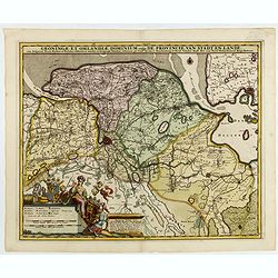
Groningae et Omlandiae Dominium vulgo De Provincie van Stadt en Lande, cum subjacent. Territ. Praefect. Et Tractibus. [Lud Tjarda â Starckenburg Nicol:Visscher. (P)
Detailed map of the northern Dutch region of Groningen with figurative cartouche and coats of arms. The town of Groningen in the center, Emden just on the right. Engraved...
Date: Amsterdam, 1685
Selling price: ????
Please login to see price!
Sold in 2015
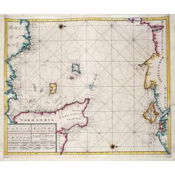
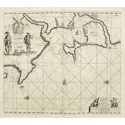
Nieuwe Zeekaart van het Tweede gedeelte van het Canaal Tusschen Engeland en Vrankryk. / ...Chanell betwext England and France.
A detailed chart of the Channel with the coasts of Normandy and part of Bretagne with Guernsy and Jersey and the south coast of England between Chichester and Exmouth wit...
Date: Amsterdam, ca 1685
Selling price: ????
Please login to see price!
Sold in 2019
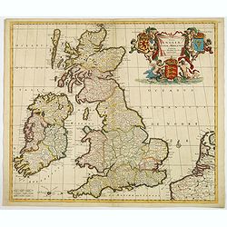
Novissima et Accuratissima Totius Angliae Scotiae et Hiberniae. . .
This is a rare Danckerts edition, of a large decorative map of the British Isles that is filled with excellent detail on towns and counties. It is funrnished with a strik...
Date: Amsterdam ca 1685
Selling price: ????
Please login to see price!
Sold in 2019
![[Lot of 6 maps of the eastern Mediterranean] Estats / du Grand Seigneur / des Turcs / en Europe, en Asie et en Afrique](/uploads/cache/18520-250x250.jpg)
[Lot of 6 maps of the eastern Mediterranean] Estats / du Grand Seigneur / des Turcs / en Europe, en Asie et en Afrique
An attractive large-format map showing the Turkish empire in Europe, Asia and Africa, comprising the eastern Mediterranean and the Near East. Embellished with a large t...
Date: Amsterdam, c. 1685
Selling price: ????
Please login to see price!
Sold in 2022
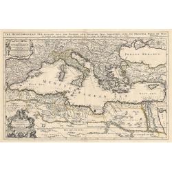
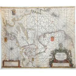
Mediterranean Sea divided into its Principall Parts of Seas
This marvelous very rare map depicts the Mediterranean Sea including its entire coastline, and much of the Ottoman Empire as it was in the late 17th century.The map is de...
Date: London, 1685
Selling price: ????
Please login to see price!
Sold in 2023
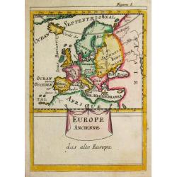
Europe Ancienne.
A map of ancient Europe from the German edition of the "Description de l' Univers".
Date: Paris, 1686
Selling price: ????
Please login to see price!
Sold
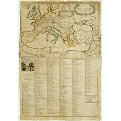
De Beschryving van de Reysen Pauli en Van de Andere Apostelen.
Dutch so-called ' Staten' bibles, published between 1637 and c. 1760, contained five maps: The World, ' Paradise', The Perigrinations, The Promised Land Canaan, The Trave...
Date: Amsterdam / Dordrecht, H.,J., en M. Doornick 1682-1686
Selling price: ????
Please login to see price!
Sold
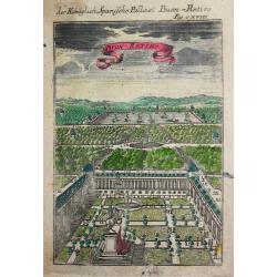
Der Könichlich Spanische Pallast Buon-Retiro.
Alain Manneson Mallet (1603-1706) published in 1683 his ' Description de l' Univers' in 5 volumes. In 1686 a German edition appeared.
Date: Paris, 1686
Selling price: ????
Please login to see price!
Sold
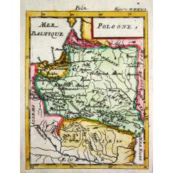
Pologne.
Alain Manneson Mallet (1603-1706) published in 1683 his ' Description de l' Univers' in 5 volumes. In 1686 a German edition appeared.Map of Poland. From the German editio...
Date: Frankfurt, 1686
Selling price: ????
Please login to see price!
Sold
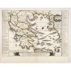
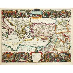
La Grece, ou Partie Meridionale de L'Empire De Turcs en Europe, avec La Table Alphabetique . . .
Uncommon map of the Greek Islands by Pierre Du Val, published in Paris. Shows a number of early sea routes through the islands.
Date: Paris, 1686
Selling price: ????
Please login to see price!
Sold in 2023
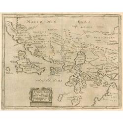
Epirus hodie Canina cum Maris Ionii Insulis Corcyra seu Corfu Cephalenia seu Cefalogna etc.
Attractive map of the northwestern coast of Greece and part of present-day Albania. The large allegorical title cartouche features a man with a book representing Wisdom, ...
Date: Wittenberg, 1686
Selling price: ????
Please login to see price!
Sold in 2010
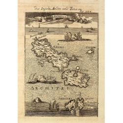
Die Inseln Andro und Tine / I d'Andro et de Tine
Decorative engraved view of the Greek Cyclades Isles Andros and Tinos from Alain Manesson Mallet. With several ship in a sea battle.
Date: Frankfurt, 1686
Selling price: ????
Please login to see price!
Sold in 2010
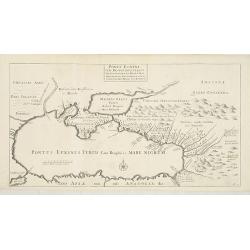
Ponti euxini cum regionibus versus septentrionem et orientem adjacentibus nova tabula.
A rare map of the Black Sea area from the travels of Sir Joan Chardin ( 1643-1713.) into Persia and the East Indies. See Copac . John Chardin (1643-1712) was the son of a...
Date: London, Moses Pitt, 1686
Selling price: ????
Please login to see price!
Sold in 2010
A New Mapp of the Kingdom of Hungary and the States that have been Subject to it, which are at Present the Northern Parts of Turkey in Europe
Rare map of Hungary published by Philip Lea. In upper left corner a dedication to George Prince of Denmark and Norway by Richard Palmer. Engraved by R. Palmer, signed low...
Date: London, 1686
Selling price: ????
Please login to see price!
Sold in 2012
Nouvelle Carte Generale des Dix sept Provinces des Pays Bas. 1686
Unrecorded map of the Low Countries with a decorative tittle cartouche upper right corner. This is a reworked plate as remains of previous texts are still visible in the ...
Date: Paris, 1686
Selling price: ????
Please login to see price!
Sold in 2013
The Scenography of a Town & Castle
A very detailed copper engraved city plan published in "The Gentleman's Recreation" in 1686. It shows "the outworks and the manner of carrying on a siege&q...
Date: London - 1686
Selling price: ????
Please login to see price!
Sold in 2013
Pas Caart van de Noort Zee Verthoonende in zich Alle de Custen en Havens daer Rontom Gelegen. . .
Scarce nautical panoramicchart of the North Sea, oriented to the West, it shows the coastlines and locations with great details. It has a sequence number 2 in lower right...
Date: Amsterdam, 1686
Selling price: ????
Please login to see price!
Sold in 2013
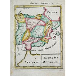
Espagne Moderne.
Alain Manneson Mallet (1603-1706) published in 1683 his ' Description de l' Univers' in 5 volumes. In 1686 a German edition appeared.A map from Alain Manesson Mallet's 'D...
Date: Paris, 1686
Selling price: ????
Please login to see price!
Sold in 2019
Isola Di Malta Gozzo comino e Cominotto...
Giacomo Rossi's fine late 17th century map of Malta and Gozzo. Engraved by Francesco Donia. Issued in Il Mercurio geografico In lower center a decorative cartouche.The ca...
Date: Rome, 1686
Selling price: ????
Please login to see price!
Sold in 2015
Descritione delli principati della Moldavia e Valachia / tolta da Giacomo Cantelli da Vignola.
Scarce map of the region between the Danube, Nistru, and Dnieper Rivers along the Black Sea - present-day Ukraine and Romania. Excellent detail throughout. Large and deco...
Date: Rome, 1686
Selling price: ????
Please login to see price!
Sold in 2018
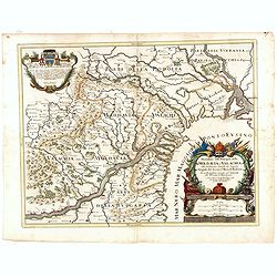
La Transilvania, Divisa su l'Esemplare delle Carte migliori e con la direzione delle pius recenti notizie nelle sue Cinque Nationi. . .
Rossi's map of Transylvania, based upon Sanson's map, but with revised Italian nomenclature. The engraver was Giorgio Widman.Issued in a second edition of Il Mercurio geo...
Date: Rome, 1686
Selling price: ????
Please login to see price!
Sold in 2015
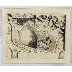
Pianta di Maina.
An interesting map showing the ruins of the fortress in ancient Cersapoli. Tall mountains in the background with a ribbon title cartouche. By Coronelli in Venice in 1686....
Date: Venice, 1686
Selling price: ????
Please login to see price!
Sold in 2018
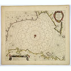
De Zee Custen van Vrancryck tusschen Swartenes en C.de la Hague, Als mede de Custen van Engelandt. . .
A decorative late seventeenth century sea chart by Doncker, showing the south coast of England from Sandwich (Kent) to Portland Bill (Dorset), and the French coastline fr...
Date: Amsterdam, ca 1686
Selling price: ????
Please login to see price!
Sold in 2018
![[Plan of a town]](/uploads/cache/43021-250x250.jpg)
[Plan of a town]
City plan of Satmar in Romania, engraved by Johann Martin Lerch (1659-1684) from Vienna.
Date: Vienna, ca.1686
Selling price: ????
Please login to see price!
Sold in 2019
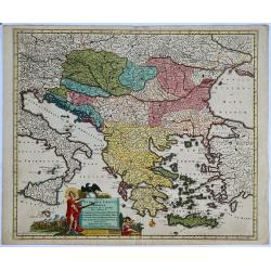
Regni Hungariae, Graeciae et Moreae. . .
A scarce original colored map centred on Greece, extending to all of the Balkans, Hungary, Romania, Aegean Sea and parts of Austria, Italy and Germany of the 17th century...
Date: Amsterdam, before 1686
Selling price: ????
Please login to see price!
Sold in 2019
-250x250.JPG)
Insulae Canariae alias Fortunatae
A 17th century copper-engraved map (nautical chart) of the Canary Islands and Madeira, from a French edition of Olfert Dapper's ´Naukeurige Beschrijvinge der Afrikaensch...
Date: Amsterdam, 1686
Selling price: ????
Please login to see price!
Sold in 2023
La Carte des Conciles..
From his first edition of his only folio atlas, the map is relied upon the map of his uncle, Nicolas Sanson. Engraved by I.Somer.A nice map of Europe on one sheet, and a ...
Date: Paris, 1687
Selling price: ????
Please login to see price!
Sold
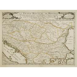
Le grand royaume de Hongrie..
Rare. Showing the countries along the river Donau.
Date: Paris 1687
Selling price: ????
Please login to see price!
Sold
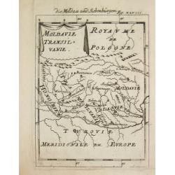
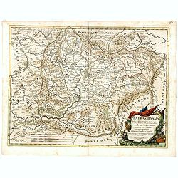
Moldavie Transilvanie.
Alain Manneson Mallet (1603-1706) published in 1683 his ' Description de l' Univers' in 5 volumes. In 1686 a German edition appeared.Map of Rumania. From the German editi...
Date: Paris, 1687
Selling price: ????
Please login to see price!
Sold
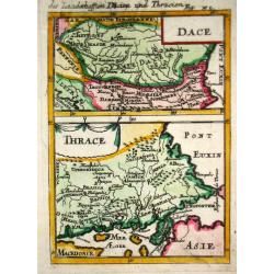
Dace/ Thrace.
Alain Manneson Mallet (1603-1706) published in 1683 his ' Description de l' Univers' in 5 volumes. In 1686 a German edition appeared.Map of the ancient Balkan. From the G...
Date: Paris, 1687
Selling price: ????
Please login to see price!
Sold in 2019