Browse Listings in Europe
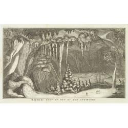
Marmere grot op het eiland Antiparos.
Marble Cave of Antiparos, who is an island in the island group Cyclades in the Aegean Sea, in the modern eparchy of Naxos. The cave itself, which is about 150 feet by 100...
Date: Amsterdam, c.17
Selling price: ????
Please login to see price!
Sold in 2014
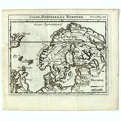
Suede, Danemark, et Norwege.
Scarce small map of Scandinavia based on cartography of Guillaume Delisle (. Published in "Nouveau traité de geographie par M**** ", published by La veuve Lott...
Date: Paris, La veuve Lottin & Butard, P.G. Le Mercier, Rollin, David, Delag
Selling price: ????
Please login to see price!
Sold in 2016
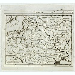
Pologne.
Scarce small map of Poland based on cartography of Guillaume Delisle. Published in "Nouveau traité de geographie par M**** ", published by La veuve Lottin &...
Date: Paris, La veuve Lottin & Butard, P.G. Le Mercier, Rollin, David, Delag
Selling price: ????
Please login to see price!
Sold in 2015
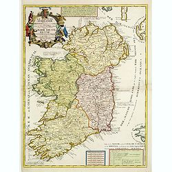
Le Royaume d'Irlande..
Uncommon map of Ireland. A visually stunning map with a large title cartouche. This large one-sheet map was produced by the Venetian cosmographer Vincenzo Coronelli when ...
Date: Paris 1690 / CORONELLI,P.
Selling price: ????
Please login to see price!
Sold
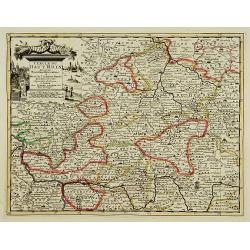
Lot of 3 maps of Germany.
Robert de Vaugondy: Empire d'Allemagne, 24 cm x 28 cm. Van der AA : Cercle du Haut Rhin, 22,5cm x 29 cm: L'Allemagne, 22,5 cm x 29 cm.The three maps are well-engraved.
Date: Paris/ Leiden
Selling price: ????
Please login to see price!
Sold
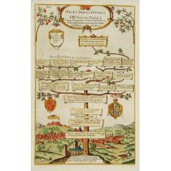
Reges Arpag Veteres..
A family tree of the rulers of Aragon starting with Ennicus (832-861). In lower part a view of Burgos.
Date: England
Selling price: ????
Please login to see price!
Sold
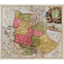
![[Bottom of Very Large Map] The Duchy of Brabant.](/uploads/cache/98717-250x250.jpg)
[Bottom of Very Large Map] The Duchy of Brabant.
This the bottom of a very large English map showing the following regions: Duchy of Brabant, Luxemburg, Duchy of Limburg, Bishoprick, French Flanders, County of Artois, C...
Date: Unknown
Selling price: ????
Please login to see price!
Sold in 2017
Ducatus Bremae et Ferdae nova tabula.
A very decorative and detailed map with Hamburg on the river Elbe. Also including Oldenburg and Bremen. With a very decorative title cartouche showing putti and allegoric...
Date: Nuremberg, 18th century
Selling price: ????
Please login to see price!
Sold
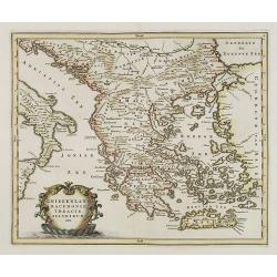
GREECE.
Map of Greece. Macedonia, western coast of Turkey and part of Italy. Cartouche in the left hand bottom with titles. From the book "History of the Jews" by Humph...
Date: The netherlands 18th. century.
Selling price: ????
Please login to see price!
Sold in 2008