Browse Listings in Europe > Luxembourg
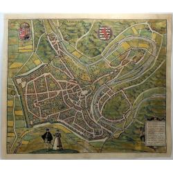
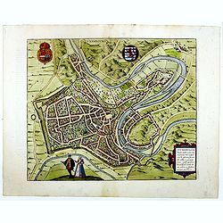
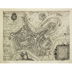
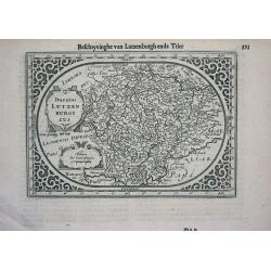
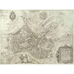
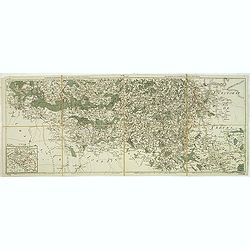
Lutzenburgum Ducatus Eiusdem Nominus. . .
A lovely birds-eye view of Luxemburg with detail even of single buildings. Translated “Luxembourg, old capital of the duchy of the same name, it was once noteworthy on...
Date: Cologne, 1572
Selling price: ????
Please login to see price!
Sold in 2018
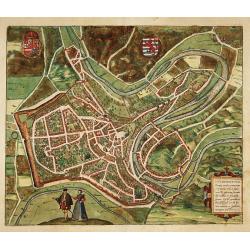
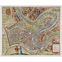
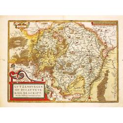
Lutzenburgum..
Very decorative and detailed bird's-eye view of the town of Luxembourg.From the greatest publication in this genre!. The "Civitates" was compiled and written ...
Date: Cologne, 1580
Selling price: ????
Please login to see price!
Sold in 2011
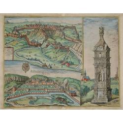
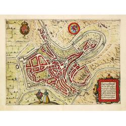
Lucenburgum.
Very decorative and detailed view of the town of Luxembourg, including the Prince's Peter place.
Date: Cologne, 1580
Selling price: ????
Please login to see price!
Sold in 2008
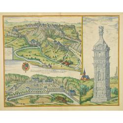
Lucenburgum.
Very decorative and detailed view of the town of Luxembourg, the monument of Igel and the Palace of Mansfeld.
Date: Cologne, 1580
Selling price: ????
Please login to see price!
Sold in 2009
Lutzenburgum. . .
Very decorative and detailed bird's-eye view of the town of Luxembourg.From the greatest publication in this genre!. The Civitates was compiled and written by George Brau...
Date: Cologne, 1580
Selling price: ????
Please login to see price!
Sold
Luxembourg - Lutzenburgum, Ducatus eiusdem Nominis, Vetus et Primaria Urbs...
Very decorative and detailed bird's-eye view of the town of Luxembourg. Includes the fortifications, numerous tiny buildings, streets, fields, trees, and the Alzette rive...
Date: Cologne, c1580
Selling price: ????
Please login to see price!
Sold in 2014
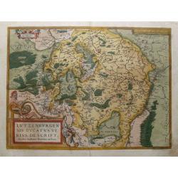
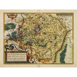
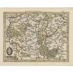
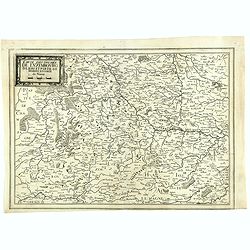
Lutzenburgensis Ducatus Veriss Descript.
Early map of the area of Luxembourg from Ortelius great "Theatrum Orbis Terrarum" the first modern atlas. Based on the 1551 manuscript map of Jacques Surhon. Th...
Date: Antwerp, 1584
Selling price: ????
Please login to see price!
Sold in 2015
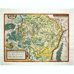
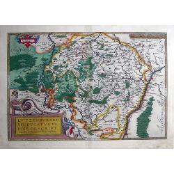
Lutzenburgensis Ducatus veriss descript.
Prepared by Jacob Surhon who made a manuscript map of Luxembourg for which he received 500 Livres from Charles V in 1551. For security reasons the map was not published. ...
Date: Antwerp, 1584
Selling price: ????
Please login to see price!
Sold in 2014
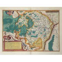
Lutzenburgensis Ducatus veriss descript.
Prepared by Jacob Surhon who made a manuscript map of Luxembourg for which he received 500 Livres from Charles V in 1551.For security reasons the map was not published. O...
Date: Antwerp 1587
Selling price: ????
Please login to see price!
Sold in 2014
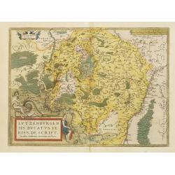
Lutzenburgensis Ducatus veriss descript .
Published by Abraham Ortelius (1527-98) in Antwerp, 1587. Written in a simple cartouche lower left: Lvtzenbvrgen Sis Dvatvs Veriss Descript. Iacobo Surhonio Montano aucto...
Date: Antwerp, 1587
Selling price: ????
Please login to see price!
Sold in 2010
Lutzenburgen sis Ducatus Veriss. Descript
A attractive map of Luxembourg : title cartouche on the lower left corner. From 'Theatrum Orbis Terrarum [Atlas of the Whole World]'.Iacobo Surhonio Montano auctore.
Date: Antwerp, 1590
Selling price: ????
Please login to see price!
Sold
Lutzenburgensis Ducatus Veriss Descript.
Map of the Luxembourg published by Ortelius, manuscript map prepared by Jacob Surhon. Surhon was paid 500 Livres for the manuscript map by Charles V in 1551. The map was ...
Date: Antwerp, c. 1600
Selling price: ????
Please login to see price!
Sold in 2010
Trier et Lutzeborg.
Small map of Luxembourg, from the first French-text edition of Jodocus Hondius' Atlas Minor.Shortly after the publication of the big folio-atlases the need was apparently...
Date: Amsterdam, 1608
Selling price: ????
Please login to see price!
Sold in 2011
Lutzenbourg / Lutzenburgu,
From Ludovico Guicciardini.'s description of the Netherlands ' Beschrijvinghe van alle de Nederlanden anderssins ghenoemt Neder-Duytslandt ', published by Willem Blaeu.A ...
Date: Amsterdam, W.Blaeu, 1612
Selling price: ????
Please login to see price!
Sold
![[Lot of 2 maps of Luxemburg]](/uploads/cache/18098-250x250.jpg)
[Lot of 2 maps of Luxemburg]
Together 2 map of Luxembourg Abraham Ortelius (1527-98), Dutch cartographer and publisher of the first modern atlas, ' Theatrum Orbis Terrarum' in 1570. Editions till ...
Date: Antwerp, 1612
Selling price: ????
Please login to see price!
Sold in 2021
Lutzenburgensis Ducatus Veriss. Descript.
Abraham Ortelius(1527-98), Dutch cartographer and publisher of the first modern atlas, ' Theatrum Orbis Terrarum' in 1570. Editions till 1612. Also an atlas of ancient ca...
Date: Antwerp, 1612
Selling price: ????
Please login to see price!
Sold in 2008
Lutzenbourg / Lutzenburgu,
From Ludovico Guicciardini.'s description of the Netherlands ' Beschrijvinghe van alle de Nederlanden anderssins ghenoemt Neder-Duytslandt ', published by Willem Blaeu.A ...
Date: Amsterdam, W.Blaeu, 1612
Selling price: ????
Please login to see price!
Sold in 2008
TRIER & LUTZENBURG. Per Gerardum Mercatorem Cum Privilegio.
Early map of the region of Luxembourg with Trier, etc. From a Latin edition of the Mercator Hondius atlas of 1613.
Date: Duisburg and then Amsterdam, (1585) 1613
Selling price: ????
Please login to see price!
Sold in 2012
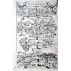
Comites Ac Duces Lucelburgici...
Rare copper engraved plate showing a genealogical tree of rulers of Luxembourg and Bohemia. With a nice and detailed view of the city of Luxembourg below. Highly decorati...
Date: Strasbourg, 1627
Selling price: ????
Please login to see price!
Sold in 2014
Ducatus LUTZENBURGICUS
Janssons desirable miniature-map of Luxembourg and surroundings, engraved for Mercators Atlas Minor (page 393-Ddd). Very detailed with well engraved symbols representing ...
Date: Amsterdam, c.1628
Selling price: ????
Please login to see price!
Sold
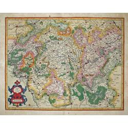
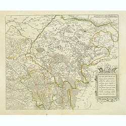
Trevirensis Archiepiscopatus, et Lutzenburgi Ducatus.
Includes the region between Mass and Mosel. Title in decorative cartouche surrounded with coats of arms : Archbishopric of Trier and Duchy of Luxembourg./>From early o...
Date: Amsterdam, 1634
Selling price: ????
Please login to see price!
Sold in 2017
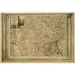
Carte des Duches de Luxembourg Iuliers et Partie de Brabant et Comte de Namur.
Detailed map of Luxembourg, published in "Theatre des Gaules", in 1637. Interestingly the title is printed from a separate copper plate. No date or publishers n...
Date: Paris, 1637
Selling price: ????
Please login to see price!
Sold
Lutzenburg Ducatus.
Fine map of Luxembourg.
Date: Amsterdam 1638
Selling price: ????
Please login to see price!
Sold
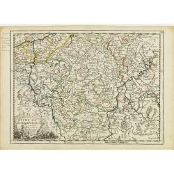
Luxenburgicus ducatus, septem Comitatibus. . .
Map of Luxembourg. Seldom available for purchase. Very rare!Lower right hand corner of copper plate was cut out. Jean Boisseau (fl.1637-1658) French geographer, topograph...
Date: Paris, 1643
Selling price: ????
Please login to see price!
Sold in 2015
Lutzenburg Ducatus.
Staéndard map of Luxemburg. More about maps by Willem Blaeu. [+]
Date: Amsterdam, 1645
Selling price: ????
Please login to see price!
Sold in 2019
Lutzenbourg
This map in its earliest form by Jacob Van Deventer served as the model for Braun and Hogenberg?s 1581 map of the city. This Guicciardini map, with the engraved plate n...
Date: Amsterdam 1648
Selling price: ????
Please login to see price!
Sold
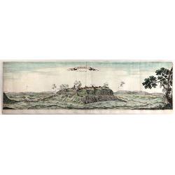
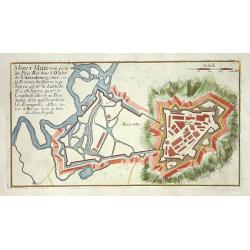
Monmedi en Luxemberg.
A very fine copper engraving featuring the Citadel of Montmedy. In 1221, the first castle of Montmédy was built on top of a hill by the Count of Chiny. Montmédy soon be...
Date: Paris, 1658
Selling price: ????
Please login to see price!
Sold in 2018
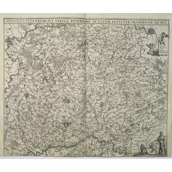
Ducatus Lutzenburgici Tabula Nuperrime In Lucem Edita Per Fredericum De Wit.
Popular map of Luxembourg, however this edition has the number "V" in the upper right corner. RARE.
Date: Amsterdam, 1680
Selling price: ????
Please login to see price!
Sold in 2013
Ducatus Lutzenburgi Novissima et Accuratissima Delineatio.
West to the top. Very detailed and fine map of Luxembourg, including the towns of Namur, Liege, Trier and Metz.
Date: Amsterdam 1680
Selling price: ????
Please login to see price!
Sold
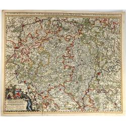
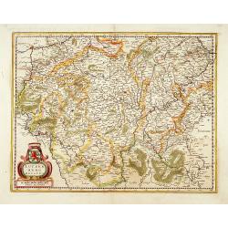
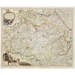
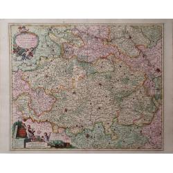
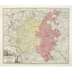
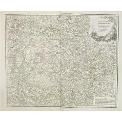
Luxembergensis Ducatus. Tam in Ejusdem Minores Quam Principales Ditiones Peraccurate Distinctus.
A strikingly decorative map of Luxemburg by Nicholas Visscher II. Taken from the his atlas “Germania Inferior, sive XVII Provinciarum Geographicae generales ut et parti...
Date: Amsterdam, 1684
Selling price: ????
Please login to see price!
Sold in 2016
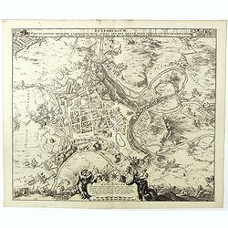
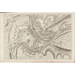
Luxemburgum, Ducat: Cognom: Metropol: á Chimacens: Princ: Stren: Def: Reg: Galliae Armis Vero Occup: IV Iunii Ao. MDCLXXXIIII Luxembourg Ville Capitale . . .
Siege and bombardment of the city of Luxembourg by the French army under the command of Marshal de Créquy, June 4, 1684. Plan of the city and surroundings, in the foregr...
Date: Amsterdam, 1684
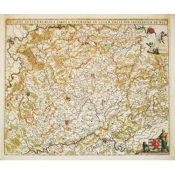
Ducatus Lutzenburgici Tabula Nuperrime in Lucem Edita per F. de Wit.
Frederick de Wit's handsome map of Luxembourg in fine original coloring. Frederik de Wit (1610-98), Amsterdam-based cartographer and publisher. 'Atlas minor', 1670,' Zee-...
Date: Amsterdam, ca 1690
Selling price: ????
Please login to see price!
Sold in 2020
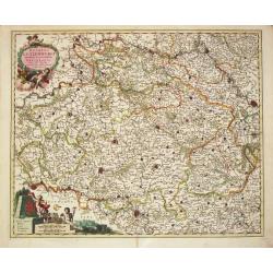
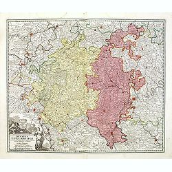
Ducatus Lutzenburgi Novissima et accuratissima Delineatio
Frederik de Wit (1610-98), Amsterdam-based cartographer and publisher. ' Atlas minor', 1670, ' Zee-Atlas', 1675, ' Atlas Major', 1690.Nicolaas Viischer's attractive map o...
Date: Amsterdam, F. de Wit, c.1690
Selling price: ????
Please login to see price!
Sold in 2011
Thionville.
Nice city plan of Thionville.
Date: Paris 1696
Selling price: ????
Please login to see price!
Sold
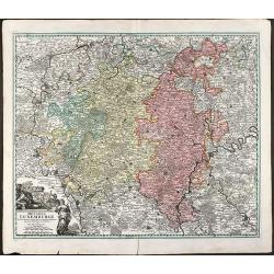
Ducatus Lutzenburgi, Noviffima et Accuratiffima Delinatio
A map of Luxembourg by Nicholas Visscher from his Atlas Minor which includes the towns of Namur, Liege, Trier and Metz, as well as major rivers. A detailed cartouche feat...
Date: Amsterdam, 1696
Selling price: ????
Please login to see price!
Sold in 2010
Le comte de Namur, partie de L'Evesche de Liege, du Luxembourg ..
Detailed map centered on Naman, and including part of Luxemburg.
Date: Paris, 1705
Selling price: ????
Please login to see price!
Sold
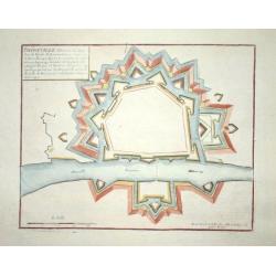
Mont Midi.
Nice plan of Mont Midi in Luxemburg.
Date: Paris 1705
Selling price: ????
Please login to see price!
Sold
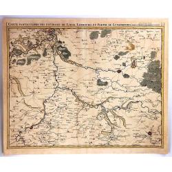
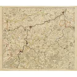
Carte Particuliere des Environs de Liege, limbourg et Partie de Luxembourg
A fine map of parts of Germany and Luxembourg by Eugene Henry Fricx in Brusselles in 1708. Published by Covens & Mortier. The map details cities, villages, forests an...
Date: BRUXELLES, 1708
Selling price: ????
Please login to see price!
Sold in 2016
Ducatus Luxemburgi . . .
Fine map of Luxembourg by J. B. Homann. With one decorative cartouche in lower left corner.
Date: Nuremberg, ca. 1720
Selling price: ????
Please login to see price!
Sold in 2011
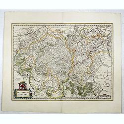
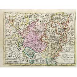
Ducatus Luxemburgi tam in Maiores quam Minores . . .
Fine map of Luxembourg by J. B. Homann. With one decorative cartouche in lower left corner.
Date: Nuremberg, ca. 1720
Selling price: ????
Please login to see price!
Sold in 2014
Ducatus Luxemburgi tam in Maiores quam Minores ejusdem Ditiones accurate distinctus et exhibitus a Ioh. Bapt. Homanno Norimbergae
Old colored map of Luxembourg by J. B. Homann. With one decorative cartouche.
Date: Nuremberg, 1720
Selling price: ????
Please login to see price!
Sold in 2009
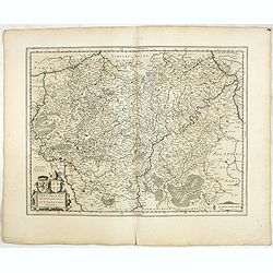
Le Duché de Luxembourg, suivant les nouvelles observations..
With decorative title cartouche upper left corner.This example is unusual in having the additional separately engraved decorative framework border around the map, the res...
Date: Amsterdam 1728
Selling price: ????
Please login to see price!
Sold in 2009
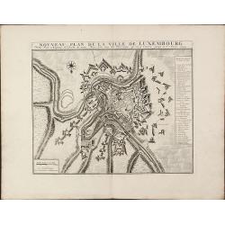
Nouveau Plan De La Ville De Luxembourg. Ville Forte et Capitale du Duche ... 1744
A quite scarce and impressive plan of Luxembourg by Covens & Mortier. Based on the plan of Baillieu 1705/10, but with new fortification as mentioned in the key '23. N...
Date: Amsterdam, 1744
Selling price: ????
Please login to see price!
Sold in 2010
Nouveau Plan de Luxembourg
A rare plan of Luxembourg by Le Rouge. Showing the fortified city with the adjacent streets, title on top.
Date: Paris, 1745
Selling price: ????
Please login to see price!
Sold in 2010
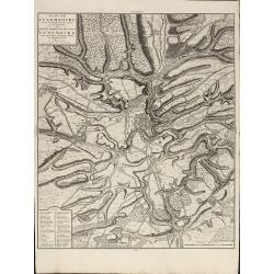
Plan de Luxembourg de ses Nouvelles Fortifications et de ses Environs
A large, scarce of Luxembourg by Covens & Mortier. Based on an earlier Jaillot map. Including a key showing 41 place names. Printed on heavy paper.
Date: Amsterdam, 1745
Selling price: ????
Please login to see price!
Sold in 2010
Carte du Duche de Luxembourg ou sont les Seign de Lompre, IV Mirwart et Villance, Partied u Duche de Bouillon, et les Consins du Lyegeois
Small scale map of region of the Duchy of Luxembourg, a former principality of the Holy Roman Empire, showing the region of southern Belgium by Robert de Vaugondy. Gilles...
Date: Paris, 1748
Selling price: ????
Please login to see price!
Sold in 2010
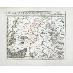
VIII. Carte du D.ché de Luxembourg.. Environs d'Arlon.
Charming small map representing part of Luxembourg, the southernmost province of Wallonia and of Belgium. Centered on Arlon.From Atlas Portatif Universel, by Robert de Va...
Date: Paris, later than 1749
Selling price: ????
Please login to see price!
Sold in 2020
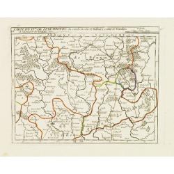
VI. Carte du D.ché de Luxembourg.. Seigneurie de Pruym.
Charming small map representing part of Rhineland-Palatinate, close to the border with Luxembourg.From Atlas Portatif Universel, by Robert de Vaugondy. Edited by : "...
Date: Paris, later than 1749
Selling price: ????
Please login to see price!
Sold in 2013
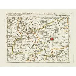
Carte Générale du Duché de Luxembourg.
Charming small map representing the Duchy of Luxembourg. Centered on Bastogne. Divided into 11 sections.From Atlas Portatif Universel, by Robert de Vaugondy. Edited by : ...
Date: Paris, later than 1749
Selling price: ????
Please login to see price!
Sold in 2013
Duché de Luxembourg.
Fine map of Luxembourg with a decorative title cartouche. George Louis Le Rouge was active from 1740- till 1780 as a publisher, and was appointed engineer for the King of...
Date: Paris 1756
Selling price: ????
Please login to see price!
Sold
![[No tittle] Le Luxembourg Electorat de Treves. N° 175. F.le 69.](/uploads/cache/30743-250x250.jpg)
[No tittle] Le Luxembourg Electorat de Treves. N° 175. F.le 69.
Map of Luxembourg. Detailed map with Sierck, Tholey. . . Prepared under the direction of César-François Cassini de Thury and engraved by Foin.Map 141 bis. [Luxembourg],...
Date: Paris, 1763
Selling price: ????
Please login to see price!
Sold in 2018
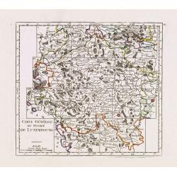
Carte du duche de Luxembourg, . . .
Detailled map of Luxembourg. Relief shown pictorially from his "Atlas Universel".Gilles Robert de Vaugondy (1688–1766), also known as Le Sieur or Monsieur Rob...
Date: Paris, 1754-1768
Selling price: ????
Please login to see price!
Sold in 2011
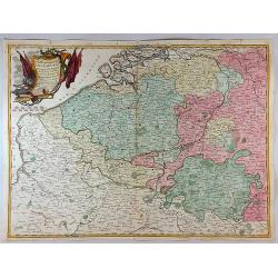
Partie Meridionale des Pays Bas Qui Comprend les Provinces de Brabant, Gueldre, Limbourg, Luxembourg, Hanaut, Namur, Flandre, cambresis et Artoir...
A striking example of Janvier's decorative map of the southern portions of the Pays Bas, or Belgium and Luxembourg. It covers modern day Belgium and Luxembourg, with adja...
Date: Paris, 1783
Selling price: ????
Please login to see price!
Sold in 2017
Kaartje van t Hertogdom Luxemburg, Volgens de Nieuwste Waarneminge.
An interesting map of Luxembourg after Isaac Tirion, engraved by Jacob Keizer and published by Elwe & Langeveld, in Amsterdam, 1786.
Date: Amsterdam, 1786
Selling price: ????
Please login to see price!
Sold in 2019
Les environs de Neufchateau, Virton, Montmedy. . .Les environs de Luxembourg, Arlon, Thionville.
Map of the east of France and Luxembourg.The map was prepared by Jean Baptiste de Bouge (1757-1833), who prepared one of the first very detailed maps of Belgium.Map 7 and...
Date: Bruxelles, 1789
Selling price: ????
Please login to see price!
Sold in 2012
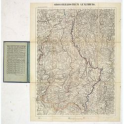
Grosserzogthum Luxemburg.
Steel engraved folding map of Luxembourg prepared by Reymann. With key in hand color to borders with Trier, France, Belgium, and Luxembourg.Reymann's Karte or Reymann'sch...
Date: Glogau, ca. 1832
Selling price: ????
Please login to see price!
Sold in 2019
