Browse Listings in Europe
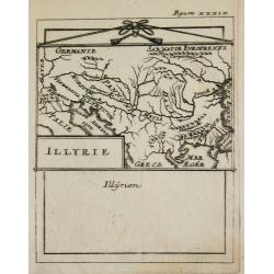
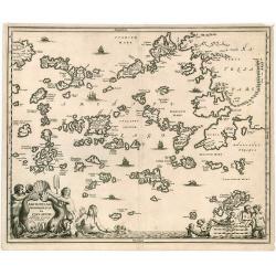
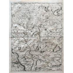
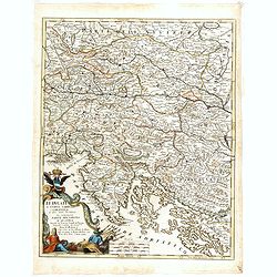
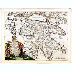
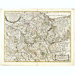
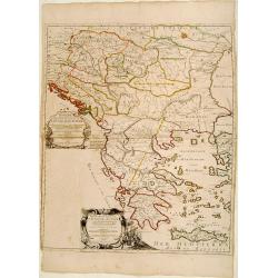
Illyrie.
Alain Manneson Mallet (1603-1706) published in 1683 his ' Description de l' Univers' in 5 volumes. In 1686 a German edition appeared.Map of the ancient Balkan. From the G...
Date: Paris, 1687
Selling price: ????
Please login to see price!
Sold
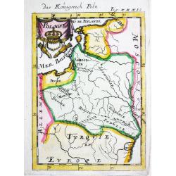
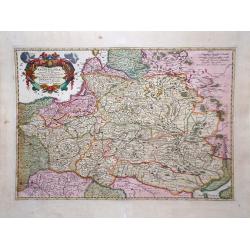
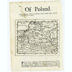
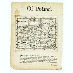
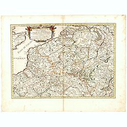
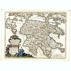
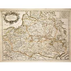
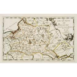
Pologne.
Alain Manneson Mallet (1603-1706) published in 1683 his ' Description de l' Univers' in 5 volumes. In 1686 a German edition appeared.Map of Poland and Lithuania. From the...
Date: Paris, 1687
Selling price: ????
Please login to see price!
Sold in 2010
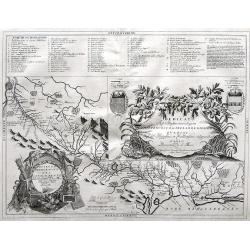
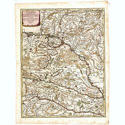
![Le grand royaume de Hongrie, la Turquie [...] Hongrie, la Transilvanie, la Valaqvie, la Moldavie, la Bosnie . . .](/uploads/cache/25589-250x250.jpg)
Le grand royaume de Hongrie, la Turquie [...] Hongrie, la Transilvanie, la Valaqvie, la Moldavie, la Bosnie . . .
Rare. Centered on Hungary but covering the present-day region from Prague to Kiev and south to Macedonia. Showing the river Danube in the center of the map.
Date: Paris, 1687
Selling price: ????
Please login to see price!
Sold in 2008
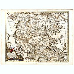
![Le grand royaume de Hongrie, la Turquie [. . .] Hongrie, la Transilvanie, la Valaqvie, la Moldavie, la Bosnie . . .](/uploads/cache/34669-250x250.jpg)
Le grand royaume de Hongrie, la Turquie [. . .] Hongrie, la Transilvanie, la Valaqvie, la Moldavie, la Bosnie . . .
Rare. Centered on Hungary but covering the present-day region from Prague to Kiev and south to Macedonia. Showing the river Danube in the center of the map.
Date: Paris, 1687
Selling price: ????
Please login to see price!
Sold in 2019
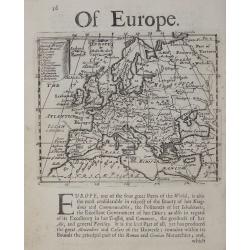
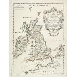
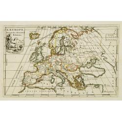
Of Europe.
Rare early English map of Europe, with a list of countries in the upper left key and a with a panel of descriptive text below.
Date: London, 1687
Selling price: ????
Please login to see price!
Sold in 2018
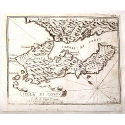
Isola di Corfu.
Little map of the Island of Corfu near Greece by Jan Peeters. From an atlas by Vincenzo Coronelli. It is signed P. Bai. With interesting ribbon title cartouche.
Date: Antwerp, 1687
Selling price: ????
Please login to see price!
Sold in 2015
Nieuwe lantkarte Van het Noorder en Ooster deel van Asia en Europa strekkende van Nova Zemla to China. . .
Three parts on one sheet. Part from large wall map. Containing a dedication to Peter Aleksejewitsj (later known as czar Peter the Great). Prepared by Nicolas Witsen, Burg...
Date: Amsterdam, 1687
Selling price: ????
Please login to see price!
Sold in 2016

TAURICA CHERSONESUS. Hodie CRIMEA.
An uncolored very rare copperplate map showing the Crimea peninsula. At the top there's a camel carriage with a tartar.
Date: Nuremberg, 1687
Selling price: ????
Please login to see price!
Sold in 2017
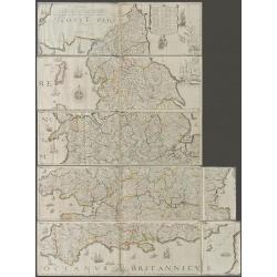
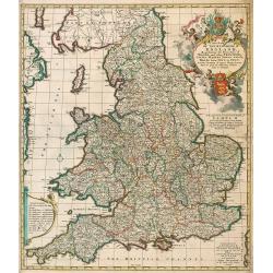
The Travellers Guide being the best Mapp of the Kingdom of England and Principality of Wales. (England & Wales wall map sections).
Fith state of Philip Lea's version of Christopher Saxton's large scale map of England and Wales first published in 1583; this state published Philip Lea, Globe maker at y...
Date: England, 1583 / ca. 1687
Selling price: ????
Please login to see price!
Sold in 2020

Veiie et perspective du Chateau de St, Cloud du Cote de L'Escalier.
An original antique perspective print by Pierre Aveline. In 1685 he obtained royal authority authorising him to reproduce 'Le Profil des Maisons Royales'. Pierre Aveline...
Date: Paris, 1687
Selling price: ????
Please login to see price!
Sold in 2018

Veiie perspective du Parterre des Cascades et de L'Etang de Fontine - Bleau.
An original antique perspective print by Pierre Aveline. In 1685 he obtained a royal authority authorising him to reproduce 'Le Profil des Maisons Royales'. Pierre Aveli...
Date: Paris, 1687
Selling price: ????
Please login to see price!
Sold in 2018
De Beschryving van de Reysen Pauli en Van de Andere Apostelen.
The Dutch so-called ' Staten' bibles published between 1637 and c. 1760, contained 5 maps: The World, ' Paradise', The Perigrinations, The Promised Land Canaan, The Trave...
Date: Amsterdam, 1688
Selling price: ????
Please login to see price!
Sold in 2008
![[British Isles ]](/uploads/cache/30326-250x250.jpg)
[British Isles ]
Charming wood block map of British Isles by the Italian XVIth and XVIIth century writer, humanist and cartographer Giuseppe Rosaccio. Taken from the 1688 Bologna "Te...
Date: Bologna, Antonio Pisarri, 1594 - 1688
Selling price: ????
Please login to see price!
Sold in 2011
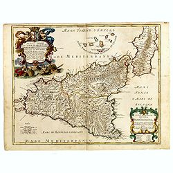
![[ Sardigne and Sicily ]](/uploads/cache/30325-250x250.jpg)
[ Sardigne and Sicily ]
Charming wood block map of Sardine and Sicily by the Italian XVIth and XVIIth century writer, humanist and cartographer Giuseppe Rosaccio. Taken from the 1688 Bologna &qu...
Date: Bologna, Antonio Pisarri, 1594 - 1688
Selling price: ????
Please login to see price!
Sold in 2011
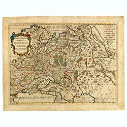
![[Central Europe ]](/uploads/cache/30324-250x250.jpg)
[Central Europe ]
Charming wood block map of Central Europe with Prague in the center, Poland, Germany, Switzerland and Austria are also included. Map by the Italian XVIth and XVIIth centu...
Date: Bologna, Antonio Pisarri, 1594 - 1688
Selling price: ????
Please login to see price!
Sold
![[ France ]](/uploads/cache/30322-250x250.jpg)
[ France ]
Charming wood block map of France by the Italian XVIth and XVIIth century writer, humanist and cartographer Giuseppe Rosaccio. Taken from the 1688 Bologna "Teatro de...
Date: Bologna, Antonio Pisarri, 1594 - 1688
Selling price: ????
Please login to see price!
Sold in 2011
![[ Black Sea region, Russia ]](/uploads/cache/30323-250x250.jpg)
[ Black Sea region, Russia ]
Charming wood block map of the Black Sea region, in the north reaching till Moscow by the Italian XVIth and XVIIth century writer, humanist and cartographer Giuseppe Rosa...
Date: Bologna, Antonio Pisarri, 1594 - 1688
Selling price: ????
Please login to see price!
Sold in 2011
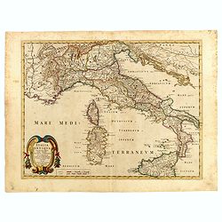
![[ Italy and Corsica ]](/uploads/cache/30320-250x250.jpg)
[ Italy and Corsica ]
Charming wood block map of Italy and Corsica by the Italian XVIth and XVIIth century writer, humanist and cartographer Giuseppe Rosaccio. Taken from the 1688 Bologna &quo...
Date: Bologna, Antonio Pisarri, 1594 - 1688
Selling price: ????
Please login to see price!
Sold in 2011
![[ Europe ]](/uploads/cache/30321-250x250.jpg)
[ Europe ]
Charming wood block map of Europe by the Italian XVIth and XVIIth century writer, humanist and cartographer Giuseppe Rosaccio. Taken from the 1688 Bologna "Teatro de...
Date: Bologna, Antonio Pisarri, 1594 - 1688
Selling price: ????
Please login to see price!
Sold in 2014
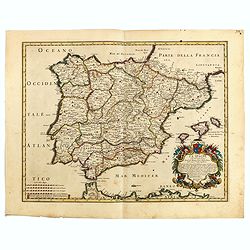
![[ Spain and Portugal ]](/uploads/cache/30318-250x250.jpg)
[ Spain and Portugal ]
Charming wood block map of Spain and Portugal by the Italian XVIth and XVIIth century writer, humanist and cartographer Giuseppe Rosaccio. Taken from the 1688 Bologna &qu...
Date: Bologna, Antonio Pisarri, 1594 - 1688
Selling price: ????
Please login to see price!
Sold in 2014
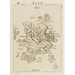
MILO.
Rare map of the island of Milo from Francesco Piacenza's : L'Egeo Redivivo o'sia Chrorographia dell'Arcipelago, e dello stato primiero, & attuale di quell'isole, regn...
Date: Modena, 1688
Selling price: ????
Please login to see price!
Sold
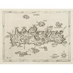
CANDIA
Rare map of the island of Creta from Francesco Piacenza's : L'Egeo Redivivo o'sia Chrorographia dell'Arcipelago, e dello stato primiero, & attuale di quell'isole, reg...
Date: Modena, 1688
Selling price: ????
Please login to see price!
Sold
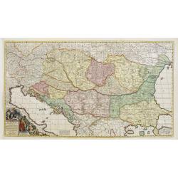
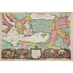
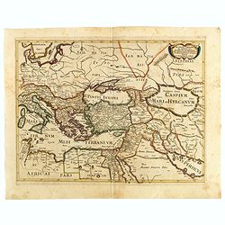
Regni Hungariae et Regionum, quae ei quodam ? Transilvania, Valachiae, Moldaviae, Serviae, Romaniae, Bulgariae..
Fine and detailed map of Hungary reaching far east as Istanbul. Decorative title cartouche.
Date: Amsterdam, 1688
Selling price: ????
Please login to see price!
Sold in 2008
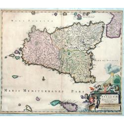
Regni Siciliae et Insulae Maltae et Gozae Cum Circumjacentibus Insulis Descriptio
Joannes De Ram map of Sicily and Malta, appeared in an Abraham Wolfgang composite atlas, published ca 1688. RARE!The map includes a decorative allegorical cartouche wit...
Date: Amsterdam, 1688
Selling price: ????
Please login to see price!
Sold in 2013
A New Mapp of the Kingdome of England, Representing the Princedome of Wales, and other Provinces, Cities, Market Towns, with the roads from Town to Town.
Interesting road map with English text by Visscher of England and Wales, focusing on the distances between cities and market towns. The map was published by Visscher, but...
Date: Amsterdam, 1688
Selling price: ????
Please login to see price!
Sold in 2009
Archipelagi Meridionalis; seu Cycladum.
Decorative map showing in Greece the Southern Aegean Islands with its neighbouring regions by Dapper/van Meur. An accurate map with many engraved small islands and place ...
Date: Amsterdam, 1688
Selling price: ????
Please login to see price!
Sold in 2009
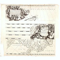
Carte des Isles Britanniques ou sont les Royaumes d'Angleterre, et d'Ecosse. . .
A map of England, with a revised date 1688 and published by the widow or daughters of Pierre Du Val (1619-83). The map shows the main towns and has a florid rococo cartou...
Date: Paris, 1665-1688
Selling price: ????
Please login to see price!
Sold in 2011
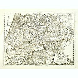
Tabula nova totius Regni Polonia ? Ducatus et Provincia Prussia, Cujavia, Mazovia, Russia Nigria, Ducatus Lithuania, Ukrania?
Map by Visscher after Sanson showing Poland, Lithuania, Latvia, Estonia and Russia with beautiful original color.
Date: Amsterdam, 1688
Selling price: ????
Please login to see price!
Sold in 2010
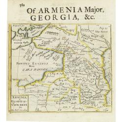
Armenia - Georgia - Comania. . .
A miniature map shows the Black Sea's east coast up to the Caspian Sea, published by Robert Morden. Copper engraved map with letterpress text describing Georgia.
Date: London, 1688
Selling price: ????
Please login to see price!
Sold in 2015
La Gran Russia . . . (map of Hungary)
Finely detailed map of northeast Hungary. The Sajó River is depicted running vertically, with the city Miskolc on its banks. Also shown is the city of Szolnok. The Carpa...
Date: Venice, 1688
Selling price: ????
Please login to see price!
Sold in 2010
Dedicato Agli Illustrissimi Signori Gio. Francesco, Girolamo, e Giovanni Querini...
Map of the Royal Canal, or Canal du Midi, in Southern France by Vincenzo Coronelli. The beautiful, decorative title cartouche is flanked by the coat of arms for the Langu...
Date: Venice, 1688
Selling price: ????
Please login to see price!
Sold in 2010
Poland by Robt Morden.
Antique Map of Poland and Lithuania by Robert Morden. Shows major rivers, regions, and towns.
Date: London, 1688
Selling price: ????
Please login to see price!
Sold in 2023
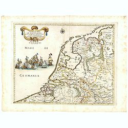
Contado d'Ollanda Parte Meridionale Dedicato All' Illustrissimo. . .
A beautifully engraved map of the central part of Holland locating the cities of Leiden, The Hague, Delft, Rotterdam, Breda, Utrecht, Amersfoort, s'Hertogenbosch, etc. Th...
Date: Venice, 1688
Selling price: ????
Please login to see price!
Sold in 2018
Poland by Robt Morden.
Antique Map of Poland and Lithuania. Shows major rivers, regions, and towns.
Date: London, 1688
Selling price: ????
Please login to see price!
Sold in 2016
Elettorato Palatinato del Reno.
Fine, detailed, copper engraved map of the course of the Rhine from Mulberg to Bacharach. Frankfort is to the right of the fancy cartouche.Giacomo Cantelli da Vignola (16...
Date: Rome, 1688
Selling price: ????
Please login to see price!
Sold in 2015
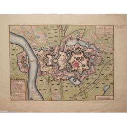
Plan de Philipsbourg Situe Sur le Rhin dans L'Eveche de Spire a Deux Lieux de Cette Ville.
This map features the bishopric fortified town of Philipsbourg on the Rhine River in Germany. It has three plain title and information cartouches.
Date: Paris, 1688
Selling price: ????
Please login to see price!
Sold in 2015
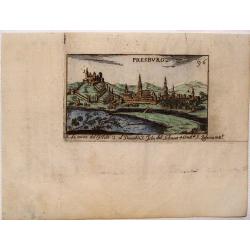
Presburg (Bratislava, Slovakia)
Detailed little city view featuring Presburg which is now Bratislava, Slovakia. It has the significant buildings labelled below. For example "La Torre del Castillo&q...
Date: Barcelona, 1688
Selling price: ????
Please login to see price!
Sold in 2015
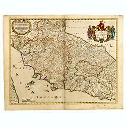
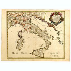
Descripttione Dello Stato Della chiesa e della Toscana...
Giacomo Rossi's fine late 17th century map of center part of Italy with old manuscript annotation in brown ink next to Rome "Republica 1849). Issued in Il Mercurio g...
Date: Rome, 1669-1688
Selling price: ????
Please login to see price!
Sold in 2015
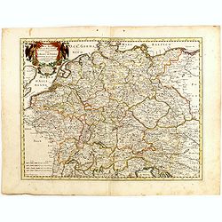
Imperto d'Allemagna diuiso in dieci Cerchi quali Cerchi...
Giacomo Rossi's fine late 17th century map of Germany. Issued in Il Mercurio geografico In upper left hand corner large title cartouche.The cartographer was Giacomo Cante...
Date: Rome, 1673-1688
Selling price: ????
Please login to see price!
Sold in 2015
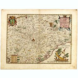
Tavola Esacatta dell'Antico Latio E Nova Campagna Di Roma...
Fine map engraved by Giorgio Wittman. Giacomo Rossi's fine late 17th century map centered on Rome, with old manuscript annotation in brown ink "Republica 1849. Issue...
Date: Rome, 1666-1688
Selling price: ????
Please login to see price!
Sold in 2015
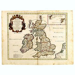
L'Isole Britanniche ouero l'Inghilterra...
Fine map engraved by Giorgio Wittman. Giacomo Rossi's fine late 17th century map of British Islands. Issued in Il Mercurio geografico In upper left hand corner large titl...
Date: Rome, 1677-1688
Selling price: ????
Please login to see price!
Sold in 2015
Isola Regno di Sicilia...
Fine map engraved by Francis Donia Messis. Giacomo Rossi's fine late 17th century map of Sicily. Issued in Il Mercurio geografico In lower right hand corner large title c...
Date: Rome, 1682-1688
Selling price: ????
Please login to see price!
Sold in 2015
La spargna...
Fine map engraved by Giorgio Widman. Giacomo Rossi's fine late 17th century map of Spain and Portugal. Issued in Il Mercurio geografico In lower right hand corner large t...
Date: Rome, 1677-1688
Selling price: ????
Please login to see price!
Sold in 2015
Russia Bianca o Moscovia...
Fine map engraved by Giorgio Widman. Giacomo Rossi's fine late 17th-century map of Russia. Issued in Il Mercurio geografico In upper left-hand corner large title cartouch...
Date: Rome, 1678-1688
Selling price: ????
Please login to see price!
Sold in 2015
Italia Antiqua cum itineribus antiquis...
Giacomo Rossi's fine late 17th century map of Ancient Italy. Issued in Il Mercurio geografico In lower left hand corner title cartouche.
Date: Rome, 1678-1688
Selling price: ????
Please login to see price!
Sold in 2015
Romani imperi qua Oriens est descriptio geographica...
Giacomo Rossi's fine late 17th century map of the Ancient Roman Empire. Issued in Il Mercurio geografico In upper right hand corner title cartouche.The cartographer was G...
Date: Rome, 1669-1688
Selling price: ????
Please login to see price!
Sold in 2015
Il Tirolo con li Vescouati di Trento e Brixen...
Giacomo Rossi's fine late 17th century map of Tirol in Austria, Italy and Switzerland. Issued in Il Mercurio geografico In lower right title cartouche.The cartographer wa...
Date: Rome, 1686-1688
Selling price: ????
Please login to see price!
Sold in 2015
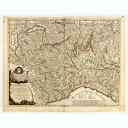
Alta Lombardia e stati ad essa circonuicini . . .
Engraved by Giorgio Widman. Giacomo Rossi's fine late 17th century map of Northern Italy. Issued in Il Mercurio geografico In lower left a tittle cartouche.The cartograph...
Date: Rome, 1680-1688
Selling price: ????
Please login to see price!
Sold in 2015
Bassa Lombardia et altre apprendici. . .
Engraved by Giorgio Widman. Giacomo Rossi's fine late 17th century map of part of Italy centered on Venice. Issued in Il Mercurio geografico In lower right a tittle carto...
Date: Rome, 1681-1688
Selling price: ????
Please login to see price!
Sold in 2015
Italia divisa ne svoi regni, prini, pati, ducati...
Giacomo Rossi's fine late 17th century map of Italy. Issued in Il Mercurio geografico In upper right a tittle cartouche.The cartographer was Giacomo Cantelli da Vignola (...
Date: Rome, 1681-1688
Selling price: ????
Please login to see price!
Sold in 2015
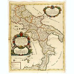
Regno di Napoli nuouamente descritto da Giacomo Cantelli da vignola...
Giacomo Rossi's fine late 17th century map of southern part of Italy. Issued in Il Mercurio geografico In upper left a tittle cartouche, with a decorative scale cartouche...
Date: Rome, 1679-1688
Selling price: ????
Please login to see price!
Sold in 2015
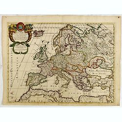
L'Europa...
Engraved by Giorgio Widman. Giacomo Rossi's fine late 17th century map of the European continent. Issued in Il Mercurio geografico In upper left corner a tittle cartouche...
Date: Rome, 1677-1688
Selling price: ????
Please login to see price!
Sold in 2015
Quartae Partis Brabantiae seu Ditionis Silvae Ducis...
Very detailed map of the fourth quarter of Brabant, including the towns of Tilburg, Den Bosch, Helmond and Eindhoven. Based on Willibrordus van der Burght map of 1635.Rar...
Date: Amsterdam, 1688
Selling price: ????
Please login to see price!
Sold in 2015
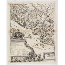
![[Two sheet map] Dalmatia maritima occidentale, Dalmatia maritima orientale descritta sù l'esemplare delle carte piú esatte e divisa. . .](/uploads/cache/36376-250x250.jpg)
[Two sheet map] Dalmatia maritima occidentale, Dalmatia maritima orientale descritta sù l'esemplare delle carte piú esatte e divisa. . .
Rossi's two sheet map of Balkans region is south eastern Europe. The engraver was Giorgio Widman.Issued in Il Mercurio geografico In lower right corner a tittle cartouche...
Date: Rome, 1677-1688
Selling price: ????
Please login to see price!
Sold in 2015
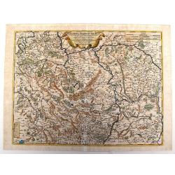
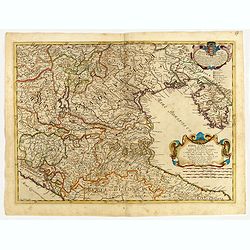
Li ducati di Stiria, Carintia è Carniola et altri stati ereditary che compongono parte del circolo d'Austria. . .
Rossi's map of Triest with parts of Croatia, Austria and Hungary. The engraver was Giorgio Widman.Issued in Il Mercurio geografico In lower left corner a tittle cartouche...
Date: Rome, 1688
Selling price: ????
Please login to see price!
Sold in 2015
Prouincie Meridionalide Paesi Bassi..
Rossi's map of Belgium and northern France and Luxembourg, based upon Sanson's map, but with revised Italian nomenclature. The engraver was Giorgio Widman.Issued in Il Me...
Date: Rome, 1677-1688
Selling price: ????
Please login to see price!
Sold in 2016
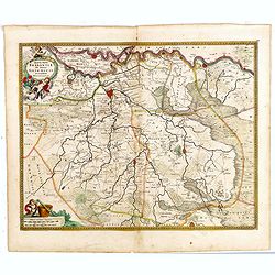
Ungaria Occidentale. . .
Rossi's map of Hungary, based upon Sanson's map, but with revised Italian nomenclature. The engraver was Giorgio Widman.Issued in Il Mercurio geografico In lower right co...
Date: Rome, 1683-1688
Selling price: ????
Please login to see price!
Sold in 2016
Macedonia Epiro Livadia Albania e Ianna / divise nelle sue parti principali da Giacomo Cantelli da Vignola. . .
Second edition of Rossi's map of Eastern Adriatic Coast, Macedonia, and extending to Negroponte and the Gulf of Lopanto, based upon Sanson's map, but with revised Italian...
Date: Rome, 1688
Selling price: ????
Please login to see price!
Sold in 2015
La Morea Ridotta dall Esemplare Antico nella moderna divisone sue Quatto Parti principali . . .
Rossi's map of Morea and neighboring regions. The engraver was Gasparo Pietra Santa.Issued in second edition of Il Mercurio geografico In lower left corner an ornate titt...
Date: Rome, 1688
Selling price: ????
Please login to see price!
Sold in 2015
Provincie Unite De Paesi Bassi . . . 1672.
Rossi's map of the Low Countries, based upon Sanson's map, but with revised Italian nomenclature. The engraver was Giorgio Widman.Giacomo Rossi's fine late 17th century m...
Date: Rome, 1677-1688
Selling price: ????
Please login to see price!
Sold in 2016
Peloponnesus Ad Antiquor . . .
Rossi's map of Peloponnese, based upon Sanson's map, but with revised Italian nomenclature. The engraver was F.D. Messanensis.Issued in Il Mercurio geografico In lower ri...
Date: Rome, 1688
Selling price: ????
Please login to see price!
Sold in 2015
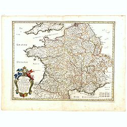
Nova Et Esatta Tavola Del Regno Di Francia..
Rossi's map of France, based upon Sanson's map, but with revised Italian nomenclature. The engraver was Giorgio Widman.In lower left corner a tittle cartouche. The cartog...
Date: Rome, 1677-1688
Selling price: ????
Please login to see price!
Sold in 2015
Marchesato, Et Elettorato di Brandeburg. . .
Rossi's map of Northern Germany, based upon Sanson's map, but with revised Italian nomenclature. The engraver was Francesco Donia Messis.Issued in a second edition of Il ...
Date: Rome, 1688
Selling price: ????
Please login to see price!
Sold in 2015
![[Two sheet map] L'Ungaria nuovamente descritta, et accresciuta di varie noti . . .](/uploads/cache/36396-250x250.jpg)
[Two sheet map] L'Ungaria nuovamente descritta, et accresciuta di varie noti . . .
Rossi's two sheet map of Hungary, based upon Sanson's map, but with revised Italian nomenclature. The engraver was Vinc. Mariotte.Issued in second edition of Il Mercurio ...
Date: Rome, 1688
Selling price: ????
Please login to see price!
Sold in 2015
Stati Della Corona di Polonia.
Title: 'Stati Della Corona di Polonia', from the La Guida Del Mercurio Geografico per Tutte Le Parti Del Mondo. Map title inside cartouche of crossed weapons and a crown ...
Date: Rome, 1683-1688
Selling price: ????
Please login to see price!
Sold in 2019
Dalmatia maritima occidentale, . . .
Left hand part of Rossi's two sheet map of Balkans region is south eastern Europe. The engraver was Giorgio Widman.Issued in Il Mercurio geografico In lower right corner ...
Date: Rome, 1677-1688
Selling price: ????
Please login to see price!
Sold in 2020
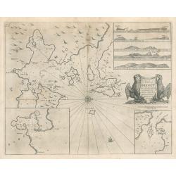
The Chiefe Harbours in the Islands of Orkney
This interesting sea chart is the work of Captain Greenville Collins, hydrographer to the King Charles II of England in the 17th century, and one of the best known Englis...
Date: London, 1688
Selling price: ????
Please login to see price!
Sold in 2023
Novissima Amstelodami Tabula per I. Bormeester
Kip's rare and decorative city map of Amsterdam, with excellent detail on the houses, streets, canals and the harbour. Orientation: south-southwest top. With a panoramic ...
Date: Amsterdam, 1688
Selling price: ????
Please login to see price!
Sold in 2023
Etats de l'Eglise qui sont le Ferrarois, le Bolognois..
A RARE and attractive map of central part of Italy centered on Siena, Florence, Lucca, etc. A visually stunning map with a large title cartouche. Includes an inset map of...
Date: Paris 1689
Selling price: ????
Please login to see price!
Sold
L'Irlande suiant les dernieres relations..
Rare miniature map of Ireland by N. de Fer, dated 1689.
Date: Paris 1689
Selling price: ????
Please login to see price!
Sold
L'Angleterre et L'Ecosse suivant des dernieres relations..
Rare miniature map of England and Scotland by N. de Fer.
Date: Paris 1689
Selling price: ????
Please login to see price!
Sold
Les Etats de Pologne. Suivant des dernieres relations..
Rare miniature map of Poland by N. de Fer.
Date: Paris 1689
Selling price: ????
Please login to see price!
Sold
L'Irlande suiant les dernieres relations..
Rare miniature map of Europe by N. de Fer, dated 1689.
Date: Paris 1689
Selling price: ????
Please login to see price!
Sold
Le Royaume de Hongrie.. Turquie en Europe.. /.. Partie Meridionale de la Turquie en Europe..
Fine map of Hungary and the European part of Turkey.To the lower left a piece of paper is pasted in and the latitudes and longitudes scales are added in print. With the a...
Date: Paris 1689
Selling price: ????
Please login to see price!
Sold
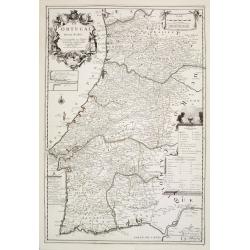
Le Portugal dedié au Roy.
From his first edition of his only folio atlas, the map is relied upon the map of his uncle, Nicolas Sanson. Engraved by Inselin.Nice map of Portugal with a very decorati...
Date: Paris 1689
Selling price: ????
Please login to see price!
Sold in 2008
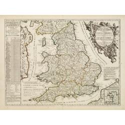
Le Royaume d'Angleterre Divise en plusieurs Parties..
Uncommon map of England. This large one-sheet map of England and Wales was produced by the Venetian cosmographer Vincenzo Coronelli when he was working in Paris in the 16...
Date: Paris, 1689
Selling price: ????
Please login to see price!
Sold in 2016
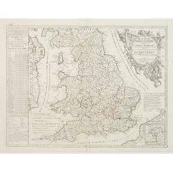
Le Royaume d'Angleterre.
An attractive map centered on England, Wales and southern part of Scotland.
Date: Paris, 1689
Selling price: ????
Please login to see price!
Sold in 2008
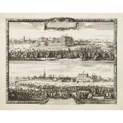
Sacrae Regiae Maj: Caroli Gustavi ..
Decorative panoramic views of Malmo and Landskrona in Sweden. Prepared by Count Erik Jönsson Dahlberg[h] (1625-1703). Military engineer and cartographer of Stockholm. He...
Date: Stockholm, 1689
Selling price: ????
Please login to see price!
Sold in 2011
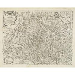
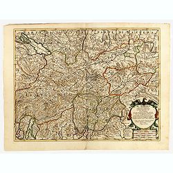
L'Helvetia . . .
A uncommon late 17th century map of part of Switzerland, including the Savoie region of France, based on the reports of Giacomo Cantelli da Vignola and published in Roma ...
Date: Rome, ca. 1689
Selling price: ????
Please login to see price!
Sold in 2009
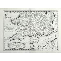
Parte Meridionale del Regno D'Inghilterra, Descritto, e Dedicato Dal P. Cosmografo Coronelli, All Illstrissimo, et Eccellentissimo Signor Caualiere Angelo Morosini, Procuratore de S. Marco, etc.
Attractive map of the Southern portion of England, extending North To 53 degrees. Shows counties, towns, roads, rivers and Islands, etc. Accompanying Italian text on vers...
Date: Venice, 1689
Selling price: ????
Please login to see price!
Sold in 2010