Browse Listings in Europe
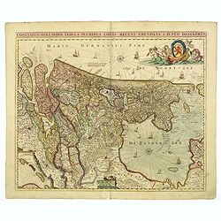
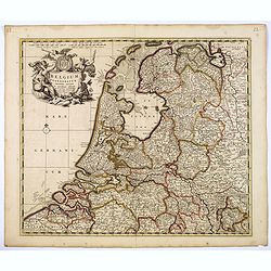
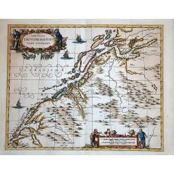
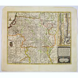
Comitatus Hollandiae. . .
Scarce Danckerts edition of this decorative map of the Netherlands. It includes decorative cartouche, compass rose, coat of arms, sailing ships, etc. Orientated west to t...
Date: Amsterdam, 1680
Selling price: ????
Please login to see price!
Sold in 2017
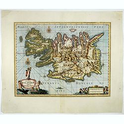
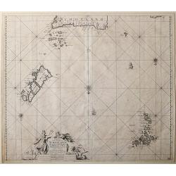
Novissima Islandiae Tabula. Sumptibus Janssonio - Waesbergiorum, Mosis Pitt et Stephani Swart.
A beautiful map of Iceland, embellished with cartouches, compass roses, rhumb lines, and many other decorative features. Moses Pitt and Steven Swart used the copper plate...
Date: Oxford, 1680
Selling price: ????
Please login to see price!
Sold in 2017
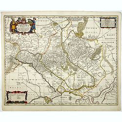
Typus Generalis Ukrainae sive Palatinatuum Podoliae, Kioviensis et Braczlaviensis terras nova delineatione exhibens. . .
Keymap based on Guillaume La Vasseur de Beauplan's map of the region published in "Description d'Ukraine." The work described Ukraine as several provinces of th...
Date: Oxford, 1680
Selling price: ????
Please login to see price!
Sold in 2020
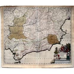
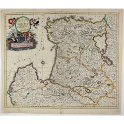
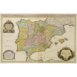
Regnorum Castellae, Novae, Andalujsae, Granadae, Valentae, et Murciae Accurata Tabula, in Episcopatus etc. divisa edita par Fredericum De Wit...
A very decorative, large, and accurate map of Southern Spain. It extends from Salamanca and Segovia in the north to the Gulfs of Valentia, Alicante and Cartgena in the ea...
Date: Amsterdam, 1680
Selling price: ????
Please login to see price!
Sold in 2023
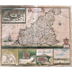
Insula sive regnum Siciliae.
Extremely decorative, fine old color example of De Wit's rare map of Sicily. It shows in details the cities of Messina, Milazzo, Palermo, Catania and Trapani.It is consid...
Date: Amsterdam, 1680
Selling price: ????
Please login to see price!
Sold in 2017
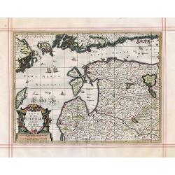
Nova Totius Livoniae accurata Descriptio.
Antique map of the Baltic States Estonia & Latvia
Date: Oxford, 1680
Selling price: ????
Please login to see price!
Sold in 2017
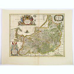
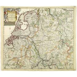
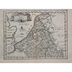
Belgium Foederatum emenate auctum et novissime editum.
A beautiful detailed map of the area of the modern Netherlands less the southern part of Limburg. The map is enhanced by a title cartouche representing the commerce, the ...
Date: Amsterdam, 1680
Selling price: ????
Please login to see price!
Sold in 2018
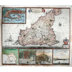
Insula sive regnum Siciliae.
An extremely decorative, large, fine old color example of De Wit's rare map of Sicily. It shows in detail the cities of Messina, Milazzo, Palermo, Catania and Trapani.It ...
Date: Amsterdam, 1680
Selling price: ????
Please login to see price!
Sold in 2019
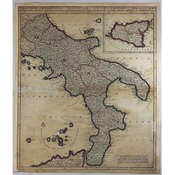
Regnum Neapolis Sisiliae et Lipariae Insulae.
A detailed map of the southern part of Italy, with a large inset of Sicily. Extends north to include Aprutium Ulterius (Aquila). Some major cities shown include; Napoli, ...
Date: Amsterdam, 1680
Selling price: ????
Please login to see price!
Sold in 2018
Ducatuum Lovoniae et Curlandiae Novissima Tabula in Quibus sunt Estonia ...
A rare and decorative map of Estonia, part of Latvia, Lithuania and Russia.
Date: Amsterdam, 1680
Selling price: ????
Please login to see price!
Sold in 2018
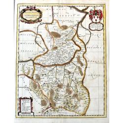
Prussia Accurate Descripta.
As indicated in the title cartouche, the map was prepared by the German cartographer Gaspher Henneberg of Erlich. In a second cartouche it is dedicated to Dr.Nicolao van ...
Date: Oxford, ca 1680
Selling price: ????
Please login to see price!
Sold in 2020
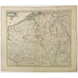
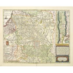
Belgii Regii Accuratissima Tabula Pluribus Locis. . .
Covering present-day Belgium, Luxembourg, Noord Brabant an Limburg in the Netherlands, and northern part of France.
Date: Amsterdam, 1680
Selling price: ????
Please login to see price!
Sold in 2023
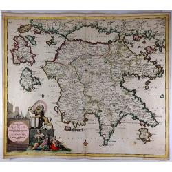
Peloponnesus Hodie Moreae Regnum.
A lovely map of the southern part of Greece / Peloponnese (Pelopónnisos) by Danckerts. With a beautifully colored cartouche with a Venetian Lion fighting against the Tur...
Date: Amsterdam, 1680
Selling price: ????
Please login to see price!
Sold in 2018
![[Lot of 3 maps] Uplandia, plus a map of the island of Ruegen by W, Blaeu and the General map of Scandinavia by Reinier & Joshua Ottens.](/uploads/cache/82017-250x250.jpg)
[Lot of 3 maps] Uplandia, plus a map of the island of Ruegen by W, Blaeu and the General map of Scandinavia by Reinier & Joshua Ottens.
An attractive map of Upland with Stockholm. With two nice cartouches. Moses Pitt (d.London,1696), planned to publish together with Janssonius' son-in-law, Janssonius van ...
Date: London, 1680
Selling price: ????
Please login to see price!
Sold in 2022
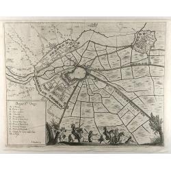
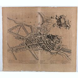
Bergue Ste. Vinox.
An interesting city map of Bergues, France by Bouttats in 1690. Featuring an aerial plan with its fortifications and surrounding landscape. A military-themed scene and a ...
Date: Antwerp, 1680
Selling price: ????
Please login to see price!
Sold in 2019
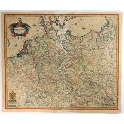
Tabula Germaniae Emendata Recens.
A lovely, detailed 1680 map of Germany, by Hugo Allard. The map covers present-day Germany, Netherlands, Luxembourg, Belgium, part of France, Austria, southern Denmark, ...
Date: Amsterdam, 1680
Selling price: ????
Please login to see price!
Sold in 2021
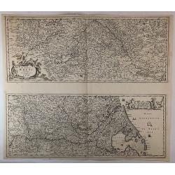
Totius Fluminis Rheni Novissima Descriptio. . .
Two maps on one sheet, one above the other, charting the course of the Rhine River., beginning on the top map, from its source at the Bodensee in Switzerland, through the...
Date: Amsterdam, 1680
Selling price: ????
Please login to see price!
Sold in 2018
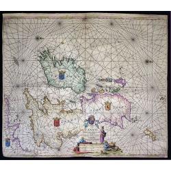
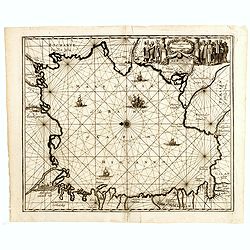
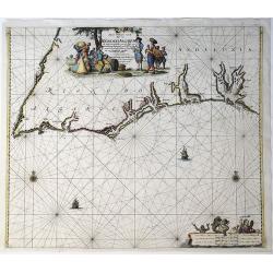
Pascaart vande Canaal, Engeland, Schotland, en Yrland.
A large nautical map of the complete British Isles, beautifully decorated with an elaborate title cartouche, coats of arms and compass roses. Lacking van Keulen’s privi...
Date: Amsterdam, before 1680
Selling price: ????
Please login to see price!
Sold in 2019
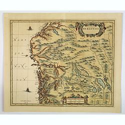
Episcopatus Bergensis.
An uncommon issue of Janssonius' map of the area around Bergen, in Norway, first issued in 1658. After Jansson's death in 1664 the plate came into the possession of his s...
Date: Oxford, ca 1680
Selling price: ????
Please login to see price!
Sold in 2019
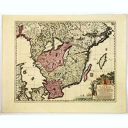
Regni Gothiae Tabula Generalis, in qua sont. . .
A striking map of southern Sweden, the islands of Gotland and Oland, a portion of northern Denmark, and Norway as far as Oslo by the Dutch cartographer and artist, Freder...
Date: Amsterdam, ca 1680
Selling price: ????
Please login to see price!
Sold in 2019
![[No title] Spitzbergen.](/uploads/cache/02427-250x250.jpg)
[No title] Spitzbergen.
Greenland split in two and Wiches Lande at the edge of the map, complete with compass-rose, galleon and monsters. Surrounded by eleven scenes of whaling from capture to b...
Date: London 1680
Selling price: ????
Please login to see price!
Sold in 2020
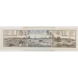
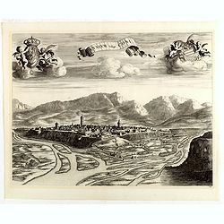
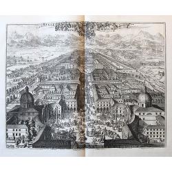
Die Churfürstliche Haubt und Residenz Stadt München, wie solche von Mitternacht gegen Mittag anzusehen ist.
Very decorative and large panoramic view of Munich, published by Michael Wening. Michael Wening (1645-1718) was born in Nuremberg in 1645 as the son of Schweinmetzger Bal...
Date: Nuremberg, 1680
Selling price: ????
Please login to see price!
Sold in 2020
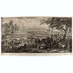
Arrivée du roi devant Douai qu'il fait investir par sa cavalerie
Showing the arrival of Louis XIV arriving near Douai. This fine engraving shows a landscape with, in the foreground, men loading donkeys in the foreground, beyond at left...
Date: Paris, ca. 1680
Selling price: ????
Please login to see price!
Sold in 2021
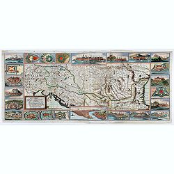
ROMANIA, THRACE, BULGARIA. -Exactissima Tabula qua tam DANUBII FLUVII PARS INFERIOR, . .
A beautifully colored map depicting the region to the lower reaches of the Danube from Belgrade to the Black Sea. Includes all of Romania, Bulgaria, most of Serbia and Th...
Date: Amsterdam, 1680
Selling price: ????
Please login to see price!
Sold in 2021
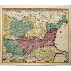
Ungarn, Siebenbürgen, Wallach, Moldau. . .
Rare map of the Danube River. Surrounded by panoramic views of Vienna, Istanbul, Raab, Hermanstat, Temeswar, Gran, etc. Including Istria, and the coast of former Yugoslav...
Date: Nurenberg, c. 1680
Selling price: ????
Please login to see price!
Sold in 2020
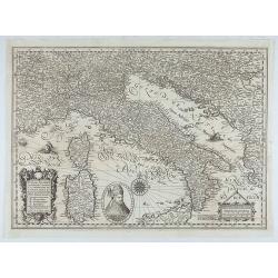
Italiae, Illirici, Sardiniae, Corsicae, et confinium regionum nova et exacta descriptio. Petro Plancio auctore. . .
Very rare map of Italy showing the area between Geneva (Switzerland), Szeged (Ottoman Hungary) and Catania (Sicily), showing patriarchates, archbishoprics and bishoprics,...
Date: Paris / London, c. 1680
Selling price: ????
Please login to see price!
Sold in 2020
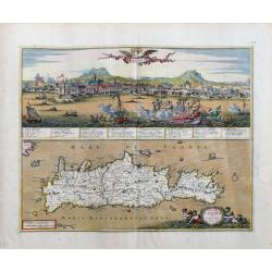
Insula Candia olim Creta.
Superbly engraved and highly beautiful map of Crete, with a large panorama of Heraklion during the Turkish siege on top. The view is very detailed with a number of shi...
Date: Amsterdam, c1680
Selling price: ????
Please login to see price!
Sold in 2023
![[Lot of 2 charts and 40 pages of text with prints of coastal profiles] Nieuwe Pascaert vande Oost Cust van Schotlandt Beginnende van Barwyck tot aen de Orcades Ylanden. [Together with a sea-chart of England's east coast.]](/uploads/cache/18507-(1)-250x250.jpg)
[Lot of 2 charts and 40 pages of text with prints of coastal profiles] Nieuwe Pascaert vande Oost Cust van Schotlandt Beginnende van Barwyck tot aen de Orcades Ylanden. [Together with a sea-chart of England's east coast.]
A fine seachart of the east coast of Scotland with the Orkney Islands. Embellished with two cartouches.From the ' Nouveau et Grand Illuminant Flambeau de la Mer'.The succ...
Date: Amsterdam, c. 1680
Selling price: ????
Please login to see price!
Sold in 2022
![[Lot of 11 maps / prints of the United Kingdom.]](/uploads/cache/100251-(1)-250x250.jpg)
[Lot of 11 maps / prints of the United Kingdom.]
An attractive map of the United Kingdom, with an inset map depicting the Orcades and Shetland islands. Embellished with two cartouches.[lot of 11 maps / prints]
Date: Amsterdam, c. 1680
Selling price: ????
Please login to see price!
Sold in 2022
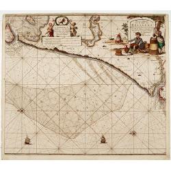
Nieuwe Paskaert van de kust van Hollandt tussen Texel en..
Sea-chart of the coast of Holland with large decorative cartouche, depicting scenes related to cheese producing.
Date: Amsterdam 1681
Selling price: ????
Please login to see price!
Sold
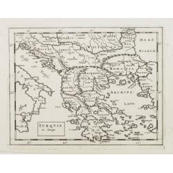
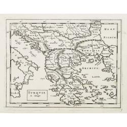
Turquie in Europe.
Extremely rare map of Greece, including also lands adjacent to the Black Sea. From: Jonas Moore, A New Geography with Maps to Each Country. ¤
Date: London, 1681
Selling price: ????
Please login to see price!
Sold
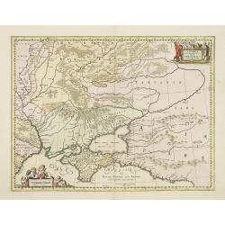
Taurica Chersonesus, Hodie Przecopsca, at Gazara dicitur.
Detailed map of the Ukraine and surrounding regions between the northern coast of the Black Sea and Moscow. Shows ports, fortified cities and the mouths of the Danube. Tw...
Date: Oxford, 1681
Selling price: ????
Please login to see price!
Sold in 2013
Turquie in Europe.
Extremely rare map of Greece, including also lands adjacent to the Black Sea. From: Jonas Moore, A New Geography with Maps to Each Country, engraved by Herman Moll.
Date: London, 1681
Selling price: ????
Please login to see price!
Sold in 2009
Die Caspische oder Hyrcanische See.
Strikingly engraved and attractive map of the Caspian Sea, showing major towns, ports, etc. Large decorative cartouche and compass rose. The engraving is neatly executed,...
Date: Nüremberg, Johann Hoffmanns, 1681
Selling price: ????
Please login to see price!
Sold in 2019
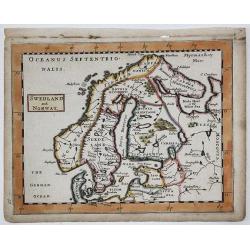
SWEDLAND and NORWAY
A copperplate map of Scandinavia / Baltic from Sir Jonas Moore's "New System of Mathematics" London, Printed by A. Godbid and J. Playford, for Robert Scott, 168...
Date: London, 1681
Selling price: ????
Please login to see price!
Sold in 2019
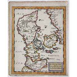
DANEMARK yizt IUTLAND, ZELAND, Sleswick, Holstein
A copperplate map of Denmark from Sir Jonas Moore's "New System of Mathematics" London, Printed by A. Godbid and J. Playford, for Robert Scott, 1681.
Date: London, 1681
Selling price: ????
Please login to see price!
Sold in 2017
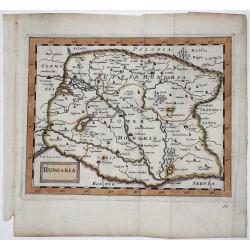
HUNGARIA
A copperplate map of Hungary from Sir Jonas Moore's "New System of Mathematics" London, Printed by A. Godbid and J. Playford, for Robert Scott, 1681.
Date: London, 1681
Selling price: ????
Please login to see price!
Sold in 2017
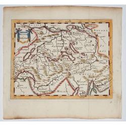
Helvetia (Switzerland) 1681
Copperplate map of Switzerland from Sir Jonas Moore's "New System of Mathematics" London, Printed by A. Godbid and J. Playford, for Robert Scott, 1681
Date: London, 1681
Selling price: ????
Please login to see price!
Sold in 2017
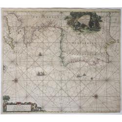
Nieuwe Paskaart, van de Kuste van Reino Do Algarve.
A sea chart of the southern Iberian Peninsula, mainly Portugal, including the coastline of the Algarve and Andalucia, from Cabo San Vincente to Palos. Full title: 'Nieuwe...
Date: Amsterdam, 1681
Selling price: ????
Please login to see price!
Sold in 2021
Paskaart Van Cales tot Cadix.
A nautical sea chart of South-Western Europe : part of: England, France, Portugal, Spain, from Dover/Calais to Almeria. Full title in a decorative cartouche at top right ...
Date: Amsterdam, 1681
Selling price: ????
Please login to see price!
Sold in 2021
Ducatus Silesiae Grotganus cum Districtu Episcopali Nissensi.
A rare regional map of Poland, centered on the cities of Otmuchów and Nysa in South West Poland near the Czech border. Extends to the North until Brieg. With the title c...
Date: Oxford, 1681
Selling price: ????
Please login to see price!
Sold in 2020
SPAIN distinguisht into all its Kingdoms..
With three very fine cartouches. With dedication to Charles II. Very detailed and scarce map of Spain, Portugal, Majorca, Minorca and Ibizza.William Berry was an well-kno...
Date: London 1682
Selling price: ????
Please login to see price!
Sold
Magni ducatus Lithuaniae Caeterarumq Regionum illi adiacentium exacta descrip. . .
Highly detailed map of Lithuania including the inset of the Dnieper River, based upon Blaeu's four sheet map. Highly detailed, extending from Cracow to the Baltic in the ...
Date: Oxford, 1682
Selling price: ????
Please login to see price!
Sold in 2010

Flandriae Partes duae, quarum altera proprietaria, altera imperialis. . .
No text on verso.! A very detailed map with Gent in the center. Lower right corner Antwerp and Vlissingen in top right. At bottom left a very decorative cartouche with a ...
Date: Oxford, 1682
Selling price: ????
Please login to see price!
Sold in 2011
Accuratissima Rheni Inferioris Mosae et Mosellae tabula. . .
Danckerts' scarce map of the rivers Rhine, Maas and Waal. Including, Belgium, Luxemburg and large part of Germany.
Date: Amsterdam, 1682
Selling price: ????
Please login to see price!
Sold in 2011
Dioecesis Trundhemiensis pars Australis.
From his "Atlas major, sive, Cosmographia universalis, adeoque orbis terrestris, maritimus, antiquus & coelestis : in quo tabulae cum descriptionibus omnium regi...
Date: Oxford, 1682
Selling price: ????
Please login to see price!
Sold in 2014
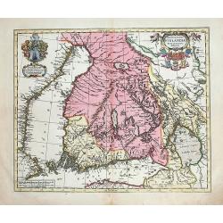
Magnus Ducatus Finlandiae nova et accurata delineatio.
Very decorative, large map depicting part of the Scandinavian countries, Russia, Finnland. With two decorative cartouches with dedication to J.Schütz. Partly colored usi...
Date: Oxford, 1682
Selling price: ????
Please login to see price!
Sold in 2012
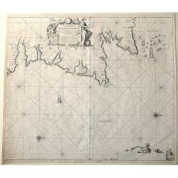
Paskaart vande Noord Cust van Schotland als mede de Eylanden van Hitlandt en Fero.
Sea chart of Northern Scotland with the Orkney islands, the Shetland Islands and the Faroe Islands, oriented to the South.From: De Nieuwe Groote Lichtende Zee-Fakkel, .....
Date: Amsterdam, 1682
Selling price: ????
Please login to see price!
Sold in 2014
Nieuwe Pascaert van de oost cust van Schotlandt beginnende van Barwyck tot aen de Orcades Ylanden.
Sea chart of the east coast of Scotland, oriented to the West. With engraved plate number 18.
Date: Amsterdam, 1682
Selling price: ????
Please login to see price!
Sold in 2013
Cuneum vulgo Coni.
A beautifully engraved and richly decorated bird's-eye view of Cuneo with the river Stura in the foreground. Blaeu used the work of BORGONIO Giovanni Tommaso Borgonio (16...
Date: Amsterdam, 1682
Selling price: ????
Please login to see price!
Sold in 2014
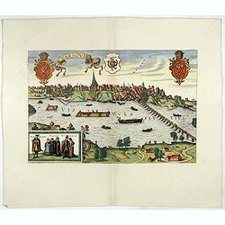
Varsovia.
View of Warsaw after Braun and Hogenberg, published in "Toonel der vermaarste Koop-Steden".
Date: Amsterdam, 1682
Selling price: ????
Please login to see price!
Sold in 2017
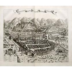
Segusium prima ab alpibus cotiis civitas.
Splendid city view of Susa, a small city west of Turin near the French border. The view was included in the fourth volume of the town book of Italy, published by the heir...
Date: Amsterdam, ca. 1682
Selling price: ????
Please login to see price!
Sold in 2018
Magni ducatus Lithuaniae Caeterarumq Regionum illi adiacentium exacta descrip. . .
Highly detailed map of Lithuania including the inset of the Dnieper River, based upon Blaeu's four sheet map. Highly detailed, extending from Cracow to the Baltic in the ...
Date: Oxford, 1682
Selling price: ????
Please login to see price!
Sold in 2017
Regiae Venationis Aedium Prospectus.
Splendid city view of Turin, which was probable engraved by Romeyn de Hooghe (1645-1708). The view was included in the fourth volume of the town book of Italy, published ...
Date: Amsterdam, ca. 1682
Selling price: ????
Please login to see price!
Sold in 2018
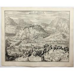
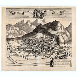
Arx et Oppidum Montismeliani.
A prospect of Montmélian, a fortress guarding the stategic bridge over the Isère River, with an inset plan of the fortress walls. It is in the Auvergne-Rhône-Alpes reg...
Date: Amsterdam, 1682
Selling price: ????
Please login to see price!
Sold in 2018
(Annecy) Annessium vulgo Annessy.
Showing in great detail a bird's-eye view of the city of Annecy, decorated with the coat of arms of the Duchy of Savoy carried by angels. In bottom numbered key.From &quo...
Date: Amsterdam, 1682
Selling price: ????
Please login to see price!
Sold in 2020
![Moustiers. [Moûtiers]](/uploads/cache/45418-250x250.jpg)
Moustiers. [Moûtiers]
Showing in great detail a bird's-eye view of the city of Moûtiers, decorated with the coat of arms of the Duchy of Savoy hold by angels. In bottom lettered key.From &quo...
Date: Amsterdam, 1682
Selling price: ????
Please login to see price!
Sold in 2020
![Abbaye d'Hautecombe. [Hautecombe Abbey]](/uploads/cache/45420-250x250.jpg)
Abbaye d'Hautecombe. [Hautecombe Abbey]
Showing in great detail a bird's-eye view of the Hautecombe Abbey, a former Cistercian monastery, later a Benedictine monastery, in Saint-Pierre-de-Curtille near Aix-les-...
Date: Amsterdam, 1682
Selling price: ????
Please login to see price!
Sold in 2020
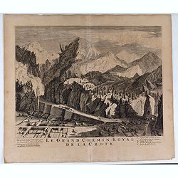
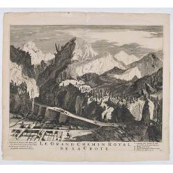
Le Grand Chemin Royal de la Crote.
Showing in great detail a bird's-eye view of Le Grand Chemin Royal de la Crote. In bottom a lettered key.From "Theatrum Sabaudiæ". Engraved by Johannes de Ram ...
Date: Amsterdam, 1682
Selling price: ????
Please login to see price!
Sold in 2020
Le Grand Chemin Royal de la Crote.
Showing in great detail a bird's-eye view of Le Grand Chemin Royal de la Crote. In bottom a lettered key.From "Theatrum Sabaudiæ". Engraved by Johannes de Ram ...
Date: Amsterdam, 1682
Selling price: ????
Please login to see price!
Sold in 2021
![Moustiers. [Moûtiers]](/uploads/cache/45507-250x250.jpg)
Moustiers. [Moûtiers]
Showing in great detail a bird's-eye view of the city of Moûtiers, decorated with the coat of arms of the Duchy of Savoy hold by angels. In bottom lettered key.From &quo...
Date: Amsterdam, 1682
Selling price: ????
Please login to see price!
Sold in 2020
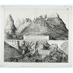
Oppidi Saurgii et viae Regiae a Carolo Emanuele I.
Showing in great detail a bird's-eye view of the city of Saorge, located in Alpes Maritimes in France.From "Theatrum Sabaudiæ". Engraved by Johannes de Ram.Joa...
Date: Amsterdam, 1682
Selling price: ????
Please login to see price!
Sold in 2021
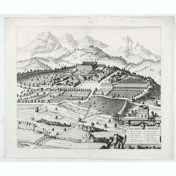
Villarium Oppidu.
Showing in great detail a bird's-eye view of the city of Villar sur Var, located in near from Nice.From "Theatrum Sabaudiæ". Engraved by Johannes de Ram.Joan B...
Date: Amsterdam, 1682
Selling price: ????
Please login to see price!
Sold in 2022
Hospitelum.
Showing in great detail a bird's-eye view of the city of Sospel, located in near from Nice and Monaco.From "Theatrum Sabaudiæ". Engraved by Johannes de Ram.Joa...
Date: Amsterdam, 1682
Selling price: ????
Please login to see price!
Sold in 2022
![Rupes Allobrogum vulgo La Roche.. [La Roche]](/uploads/cache/45944-250x250.jpg)
Rupes Allobrogum vulgo La Roche.. [La Roche]
Showing in great detail a bird's-eye view of the city. From "Theatrum Sabaudiæ". Engraved by Conraet Decker.Joan Blaeu published during his life three town-boo...
Date: Amsterdam, 1682
Selling price: ????
Please login to see price!
Sold in 2020
![[Fossano] Delinea Civitatis Fossani In Principatu Pedemontii](/uploads/cache/45946-250x250.jpg)
[Fossano] Delinea Civitatis Fossani In Principatu Pedemontii
Showing in great detail a bird's-eye view of Fossano, in the Piedmont region of Northern Italy. From "Theatrum Sabaudiæ". Engraved by J. de Ram.Joan Blaeu publ...
Date: Amsterdam, 1682
Selling price: ????
Please login to see price!
Sold in 2020
Civitas Sancti Joannis Maurianensis. (Saint Jean de Maurienne)
Showing in great detail a bird's-eye view of the town of Saint Jean de Maurienne in the Savoy region of the French Alps. From "Theatrum Sabaudiæ". Joan Blaeu p...
Date: Amsterdam, 1682
Selling price: ????
Please login to see price!
Sold in 2020
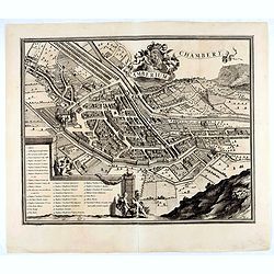
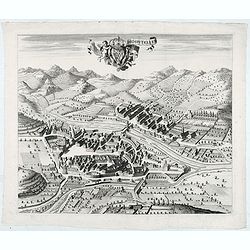
Chamberium Chambery
Showing in great detail a bird's-eye view of the city of Chambery, decorated with the coat of arms of the Duchy of Savoy hold by angels. In bottom lettered key.From "...
Date: Amsterdam, 1682
Selling price: ????
Please login to see price!
Sold in 2020
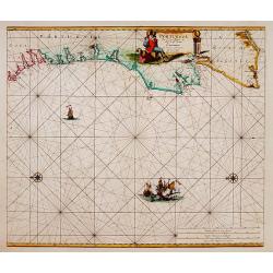
Nieuwe Pascaert van Portugaal van C.de Finisterre tot C.de S.Vincente.
Rare sea chart of Portugal.
Date: Amsterdam 1683
Selling price: ????
Please login to see price!
Sold
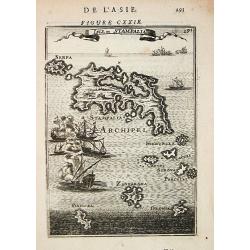
Isle de Stampalia.
Alain Manneson Mallet (1603-1706) published in 1683 his ' Description de l' Univers' in 5 volumes. In 1686 a German edition appeared. A map depicting the island of Stampa...
Date: Paris, 1683
Selling price: ????
Please login to see price!
Sold
Belgii Veteris Typus Abrahami Ortelii
Philippe Cluverius (1580-1622), geographer of Danzig, settled in Leiden (Holland) specialized in Near Easrt and Ancient Geography. His main works ' Geographicus Academicu...
Date: Amsterdam, 1683
Selling price: ????
Please login to see price!
Sold
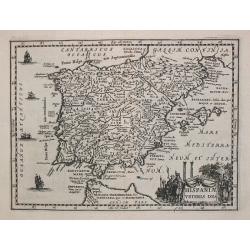
Hispaniae Veteris Des.
Philippe Cluverius (1580-1622), geographer of Danzig, settled in Leiden (Holland) specialized in Near Easrt and Ancient Geography. His main works ' Geographicus Academicu...
Date: Amsterdam, 1683
Selling price: ????
Please login to see price!
Sold
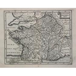
Galliae Veterus. Petrus Kaerius Caelavit.
Philippe Cluverius (1580-1622), geographer of Danzig, settled in Leiden (Holland) specialized in Near Easrt and Ancient Geography. His main works ' Geographicus Academicu...
Date: Amsterdam, 1683
Selling price: ????
Please login to see price!
Sold in 2009
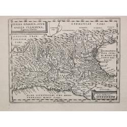
Italia Gallica, sive Gallia Cisalpina.
Philippe Cluverius (1580-1622), geographer of Danzig, settled in Leiden (Holland) specialized in Near Easrt and Ancient Geography. His main works ' Geographicus Academicu...
Date: Amsterdam, 1683
Selling price: ????
Please login to see price!
Sold
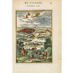
Prague.
Bird's-eye view of Prague from a neighbouring hillside. From the French text edition of Description d'Univers, 1683. by Allain Manneson Mallet (1630-1706), a well travell...
Date: Paris 1683
Selling price: ????
Please login to see price!
Sold
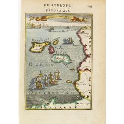
Is de Jersey et de Garnesey.
A fine and uncommon early 18th century birds-eye view of Jersey and Guernsey. Numerous tall masted ships may be seen, including two engaged in battle in the foreground.Fr...
Date: Paris 1683
Selling price: ????
Please login to see price!
Sold
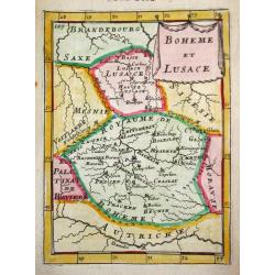
Boheme et Lusace.
Alain Manneson Mallet (1603-1706) published in 1683 his ' Description de l' Univers' in 5 volumes. In 1686 a German edition appeared.A map from Alain Manesson Mallet's 'D...
Date: Paris, 1683
Selling price: ????
Please login to see price!
Sold in 2010
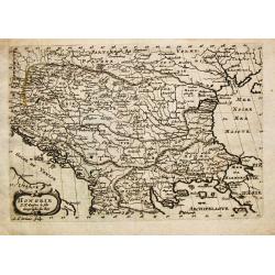
Hongrie.
Nicolas Sanson (1600-67), 'father of the French cartography' and founder of the Sanson firm. Atlas ' Cartes générales de toutes les parties du Monde', 1658-70 and a poc...
Date: Utrecht, S.de Vries / J. Ribius, 1683
Selling price: ????
Please login to see price!
Sold
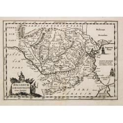
Daciarum Moesiarumque Vetus Descriptio.
A map of Rumania and Bulgaria.
Date: Amsterdam, 1683
Selling price: ????
Please login to see price!
Sold
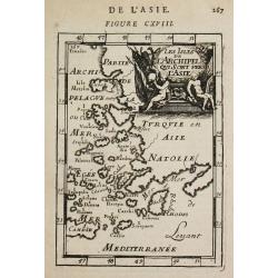
Les Isles de l'Archipel qui sont vers l'Asie.
Alain Manneson Mallet (1603-1706) published in 1683 his ' Description de l' Univers' in 5 volumes. In 1686 a German edition appeared.A map from Alain Manesson Mallet's 'D...
Date: Paris, 1683
Selling price: ????
Please login to see price!
Sold