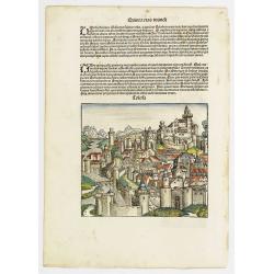
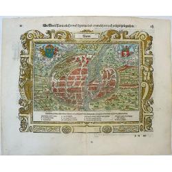
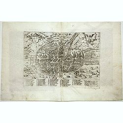
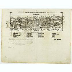
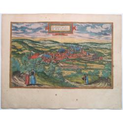
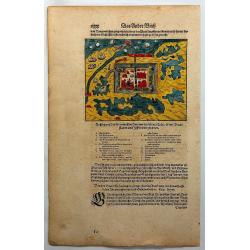
![Sexta etas Mudi. Metis. [Metz] Folio CX.](/uploads/cache/13516-250x250.jpg)
Sexta etas Mudi. Metis. [Metz] Folio CX.
A imaginary view of Metz: however the earliest obtainable view of this period. Shows in upper left a castle and to the right the cathedral depicted as a mosque. It includ...
Date: Nuremberg, 12 July 1493
Selling price: ????
Please login to see price!
Sold in 2017
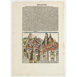
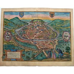
Tolosa. Folio LXXI (Toulouse)
Panoramic view of Toulouse. A imaginary view: however the earliest obtainable view of this period.Page from the richest illustrated Incunable, the famous: Nuremberg Chron...
Date: Nuremberg, 12 July 1493
Selling price: ????
Please login to see price!
Sold in 2016
Sexta Etas Mudi. /Ordo Cartusiensum.. / Nicea Urbs.. / Folio XCIIII
A imaginary view of Nice: however the earliest obtainable view of this period. On verso, it shows the first house of the Order of the Carthusians, founded by St Bruno, he...
Date: Nuremberg, 12 July 1493
Selling price: ????
Please login to see price!
Sold in 2020
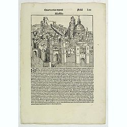
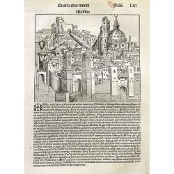
Quarta Etas Mundi. Folium.LXI
The Latin text page is illustrated with a imaginary view of Marseille, however the earliest obtainable view of this period. VERSO : Kings, Noble men and women and scienti...
Date: Nuremberg, 12 July 1493
Selling price: ????
Please login to see price!
Sold in 2013
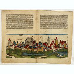
Nissa. (Nice)
A imaginary view of Nice (200x508mm.) : however the earliest obtainable view of this period. On verso the right hand part of a double page panoramic view of Lübeck in Sc...
Date: Nuremberg, 12 July 1493
Selling price: ????
Please login to see price!
Sold in 2015
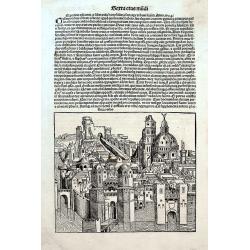
Massilia.
Very early imaginary view of Marseilles, the earliest available view of the city. There are several uncolored portraits on verso. On a full page with Latin text.
Date: Nuremberg, 1493
Selling price: ????
Please login to see price!
Sold in 2016
Nicea urbs.
Very early imaginary view of Nice in France, the earliest available view of the city. On a full page with Latin text on both side.
Date: Nuremberg, 1493
Selling price: ????
Please login to see price!
Sold in 2018
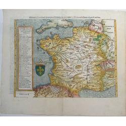
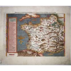
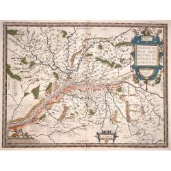
Das gantz Franckreich, so vor zeiten Gallia Narbonensis, Lugdunensis, Belgica und Celtica ist genent worden.
One of the earliest maps of France by Sebastian Münster. With the southern part of England. The title on verso is surrounded by a large and beautiful woodcut border. Fro...
Date: Basel, ca 1540
Selling price: ????
Please login to see price!
Sold in 2019
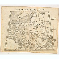
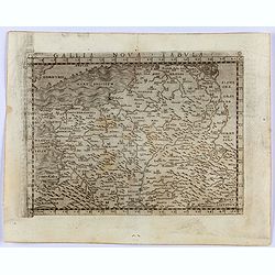
Tabula Europae III (France)
The first edition of Munster's Ptolemaic map of France appeared in his "Geographia Universalis", first published in 1540. This was a new and important edition o...
Date: Basel, Heinrich Petri, 1545
Selling price: ????
Please login to see price!
Sold in 2016
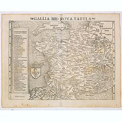
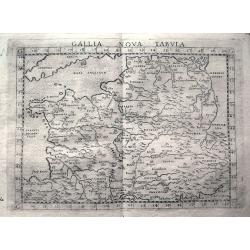
Gallia IIII Nova Tabula (France)
Sebastian Münster's map of France. Appeared in his "Geographia Universalis", first published in 1540. The Geographia was a new and important edition of Ptolemy...
Date: Basel, Heinrich Petri, 1545
Selling price: ????
Please login to see price!
Sold
Gallia Nova Tavola.
Gastaldi's modern map of France. From Giacomo Gastaldi's Atlas of 1548, which has been called the most comprehensive atlas, produced between Martin Waldseemüller's Geogr...
Date: Venice, 1548
Selling price: ????
Please login to see price!
Sold in 2021
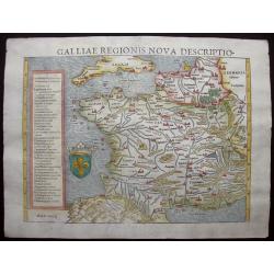
Galliae Regionis Nova Descriptio.
Sebastian Münster's handsome and fascinating 1550 map of France and Belgium from the Pyrenees to Holland, also showing the south coast of England and the Channel Islands...
Date: Basle, 1550
Selling price: ????
Please login to see price!
Sold in 2014
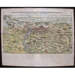
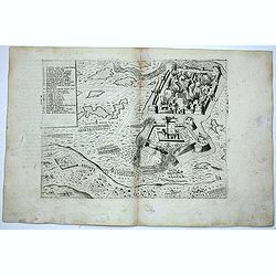
Warhaffte abcontrafactur der namhafften Statt St. Quintin sampt aller Laegerstatt und umbligenden Ort wie sie von Konigs Philippi Heer im jar 1557 belagert worden
Rare and charming woodcut of St. Quentin. A bird's eye view of the siege of St. Quentin in Aisne (France) by the forces of King Philip II of Spain, in 1557. It shows the ...
Date: Basel, H.Petri, ca. 1550
Selling price: ????
Please login to see price!
Sold in 2020
Don Gallia.
A detailed vieGravelines, from an early edition of Sebastian Münster's 'Cosmography'.Münster's 'Cosmography' was one of the most influential geographical works of the 1...
Date: Basil, c 1550
Selling price: ????
Please login to see price!
Sold in 2016
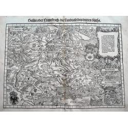
Gallia oder Franckrych / Die Landtafel des dritten Buchs.
One of the earliest available maps of France. The wood cut printed map also shows small parts of Italy, Germany, and England. Filled with place names, rivers, mountains, ...
Date: Zurich, ca 1550
Selling price: ????
Please login to see price!
Sold in 2018
Die Statt Paris etlicher mass figuriert und contrafehtet nach ietziger gelegenheit.
A remarkable cityscape, because unlike most cityscapes in the Cosmographia, where the bird's-eye perspective or the profile view on cities is used, here we find what come...
Date: Basel, H.Petri, ca. 1550
Selling price: ????
Please login to see price!
Sold in 2020
Das gantz Franckreich..Belgica und Celtica. . .
This fine and beautifully hand colored original antique map of modern contemporary France in the mid 16th century was published by Sebastian Münster in the 1550's. Date ...
Date: Basel, ca 1550
Selling price: ????
Please login to see price!
Sold in 2020
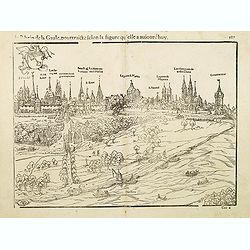
Le rhein de la Gaule, pourtraicte selon la figure qu'elle a auiourdhuy.
Panoramic town-view along River Rhine in French Alsace. In lower left HSD. There is no information available for the monogamist HSD, we think he originates from Worms.Tak...
Date: Basle, c.1560
Selling price: ????
Please login to see price!
Sold in 2014
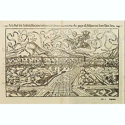
Selestat ou Schletstat, cité impériale, située au milieu du pays d'Alsace. . .
Panoramic of Sélestat in the French Alsace region. In lower right corner: RMD [Rudoplh Manuel called Deutsch who was a well-known wood-cutter].Taken from Sebastian Mün...
Date: Basle, ca. 1560
Selling price: ????
Please login to see price!
Sold in 2014
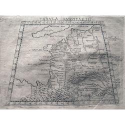
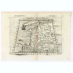
Tabula Europae III.
Ptolemaic style map of France, the Low Countries, and the Rhine river. Includes numerous historic place names. Italian text on verso.
Date: Venice, c1561
Selling price: ????
Please login to see price!
Sold in 2013
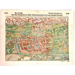
Rubeaquum Rusach (Château D'Isenbourg)
Rubeaquum Rufach is a detailed woodcut by Sebastian Münster showing the famous Château D'Isenbourg located in the heart of the vineyards on the Alsace wine route and th...
Date: Basil, 1564
Selling price: ????
Please login to see price!
Sold in 2018
![[De Galliae et eius fitu, item de eius patitione . . . . . . ]](/uploads/cache/38525-250x250.jpg)
[De Galliae et eius fitu, item de eius patitione . . . . . . ]
One text page with a map of France on the recto (7,8 x 13,5 cm). On verso, a text page in one hand , and in the other a horn from Münster's Cosmographia Universalis.The ...
Date: Basle, ca. 1564
Selling price: ????
Please login to see price!
Sold in 2018
![[De Regionibus, Ubibus et Fluviis Galliae . . . ]](/uploads/cache/38524-250x250.jpg)
[De Regionibus, Ubibus et Fluviis Galliae . . . ]
One text page with a map of Europe on the recto (12,2 x 15,5 cm). From Münster's Cosmographia Universalis.The Cosmographia by Sebastian Munster from 1544 is the earliest...
Date: Basle, ca. 1564
Selling price: ????
Please login to see price!
Sold in 2022
Tabula Europae III (France)
Early map of France. Girolamo Ruscelli first published the map in his "La Geographi di Claudio Tolomeo" (Venice, 1561). In 1574 a new plate was used which laste...
Date: Venice, 1564
Selling price: ????
Please login to see price!
Sold in 2020
Galliae exactissima descriptio.
A unique opportunity to acquire a fine example from a map from the early Lafreri school. It was the custom for Italian map sellers to bind together available maps into a ...
Date: Venice, 1566
Selling price: ????
Please login to see price!
Sold
![CHALES [Calais]](/uploads/cache/38742-250x250.jpg)
CHALES [Calais]
Rare Lafreri School town-plan of Calais, engraved by Paolo Forlani, of the Lafreri school of mapmakers, first published in "Il Primo Libro Delle Citta, Et Fortezze P...
Date: Venice, Zaltieri, (1567) 1567
Selling price: ????
Please login to see price!
Sold in 2018
Perpignan.
Extremely rare panoramic view showing the siege of the town of Perpignan in 1595. Also showing the towns of Narbonne, Rivesaltes along with the Mediterranean coast.Engrav...
Date: Venice 1568
Selling price: ????
Please login to see price!
Sold
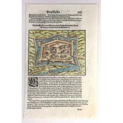
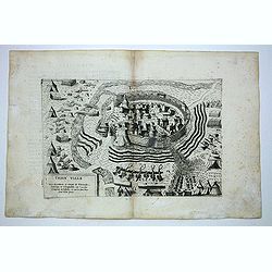
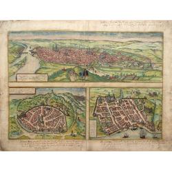
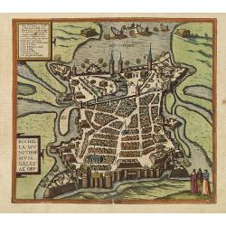
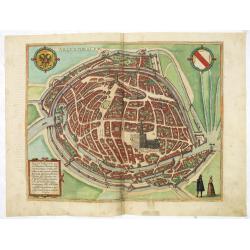
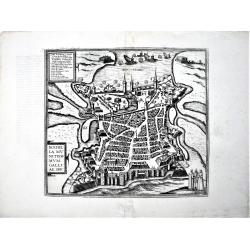
Desegno et circutio della citta di Metz.
Extremely rare panoramic view showing a plan of the siege of the town of Metz. In bottom left a numbered key 1-53. Engraved by Paolo Furlani (active 1561-1577), his addre...
Date: Venice 1568
Selling price: ????
Please login to see price!
Sold
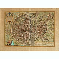
Parisi.
Rare Lafreri School town-plan of Paris, engraved by Paolo Forlani, of the Lafreri school of mapmakers, first published in "Il Primo Libro Delle Citta, Et Fortezze Pr...
Date: Venice, Zaltieri, (1567) 1568
Selling price: ????
Please login to see price!
Sold in 2011
Gravelinga.
Rare Lafreri School town-plan of Gravelines, engraved by Paolo Forlani, of the Lafreri school of mapmakers, first published in "Il Primo Libro Delle Citta, Et Fortez...
Date: Venice, Zaltieri, (1567) 1568
Selling price: ????
Please login to see price!
Sold in 2014
Guines.
Rare Lafreri School town-plan of Guines, engraved by Paolo Forlani, of the Lafreri school of mapmakers, first published in "Il Primo Libro Delle Citta, Et Fortezze P...
Date: Venice, Zaltieri, (1567) 1568
Selling price: ????
Please login to see price!
Sold in 2014
Thion ville.
Rare Lafreri School town-plan of Thionville, engraved by Paolo Forlani, of the Lafreri school of mapmakers, first published in "Il Primo Libro Delle Citta, Et Fortez...
Date: Venice, Zaltieri, (1567) 1568
Selling price: ????
Please login to see price!
Sold in 2014
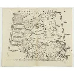
Tabula Galliae. (France)
Double-page woodcut Ptolemaic-style map by Sebastian Münster figuring France, published in the edition of Strabo by Henri Petri in 1571."Strabonis rerum geographica...
Date: Basle, Henri Petri, 1571
Selling price: ????
Please login to see price!
Sold in 2018
Lutetia, Vulgari Nomine Paris, Urbs Gallia Maxima, sequana navigabili flumine irrigatur. . . frequeta universitate excelenti, stupendi opera Tempso B. Maria..
Beautiful and early town-plan of Paris with title cartouche and figures in the foreground. The Bastille is shown at the upper center of the engraving and the Notre-Dame c...
Date: Cologne, ca. 1572
Selling price: ????
Please login to see price!
Sold
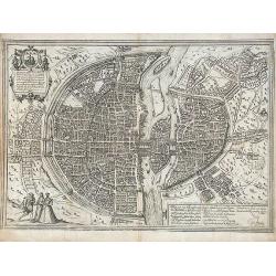
Lutetia vulgari Nomine Paris, Urbs Galliae Maxima ...
Based on Sebastian Munster's map of 1569, this exceptional town plan of 16th Century Paris depicts in details the city as it evolved from a small settlement on an island ...
Date: Cologne, 1572
Selling price: ????
Please login to see price!
Sold in 2012
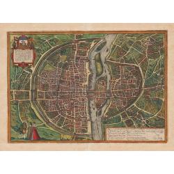
Lutetia vulgari Nomine Paris, Urbs Galliae Maxima, ...
Based on Sebastian Munster's map of 1569, this exceptional town plan of 16th Century Paris depicts in details the city as it evolved from a small settlement on an island ...
Date: Cologne, c.1572
Selling price: ????
Please login to see price!
Sold in 2013
Nimes and Bordeaux.
Text in top frame: "Rotomagus, vulgo Roan, Normandiae Metropolis depingebat Georgius Hoefnagle, cum privilegio."Lower Left Frame - Text: "Nemausus; Nismes ...
Date: Cologne, ca. 1572
Selling price: ????
Please login to see price!
Sold in 2013
Lutetia, vulgari nomine Paris, urbs Gallia...
Beautiful and early town-plan of Paris with title cartouche and figures in the foreground. The Bastille is shown at the upper center of the engraving and the Notre-Dame c...
Date: Cologne, ca. 1572
Selling price: ????
Please login to see price!
Sold in 2020
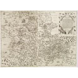
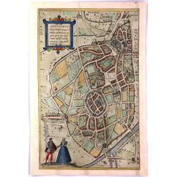
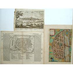
![Montpellier,Tours,Poitiers. - Monsiessulanus [on sheet with] Turo [and] Pictavis, sive Pictavia, Vernaculo Idiomate...](/uploads/cache/85900-250x250.jpg)
Montpellier,Tours,Poitiers. - Monsiessulanus [on sheet with] Turo [and] Pictavis, sive Pictavia, Vernaculo Idiomate...
Fine antique copper engraved sheet with three bird's-eye views by Braun and Hogenberg: Montpellier, Tours and Poitiers from the first volume of Braun & Hogenberg's &q...
Date: Cologne, 1572
Selling price: ????
Please login to see price!
Sold in 2021
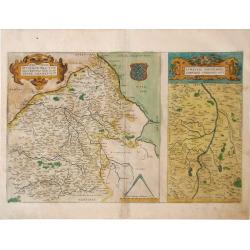
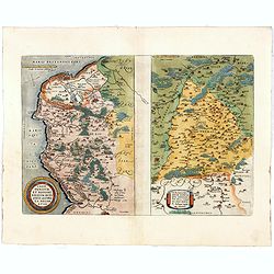
Regionis Biturigum Exactiss Descriptio per D. 10 Annem Calamaeum / Limaniae Topographia Gabriele Symeoneo Auct.
Two detailed regional maps of France by Ortelius showing the regions of Berry and Limagne. Accompanying Latin text is on verso.
Date: Antwerp, 1573
Selling price: ????
Please login to see price!
Sold in 2010
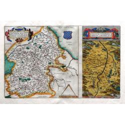
Regionis Biturigum Exactiss Descriptio per D. 10 Annem Calamaeum / Limaniae Topographia Gabriele Symeoneo Auct.
Two detailed regional maps of France by Ortelius showing the regions of Berry and Limagne. Accompanying Latin text is on verso with hand-colored rubric letters. Striking,...
Date: Antwerp, 1573
Selling price: ????
Please login to see price!
Sold in 2010
Regionis Biturigum Exactiss / Limaniae Topographia Gabriele.
Two detailed regional maps of France on one page by Ortelius; showing the regions of Berry and Limagne.The larger map covers the Loire region from Gian to Le Blang and Ar...
Date: Antwerp, 1573
Selling price: ????
Please login to see price!
Sold in 2018
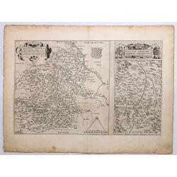
Caletensium et Bononi Ensium Ditionis Accurata delineation / Veromandy Orum Eorum Que Confini.
Two fine Ortelius maps on one sheet. The left hand map shows the Opal Coast (Côte d'Opale) within Pas-de-Calais between Gravelines to Étaples, including Calais & Bo...
Date: Antwerp, 1573
Selling price: ????
Please login to see price!
Sold in 2018
Venuxini Comitatus Nova Descr. / Gallia Narbonensis / Sabaudiae Ducat.
Interesting with three maps on one sheet. Upper left the coast of the Mediterranean Sea (with places like Narbonne, Aigues Mortes, Avignon, Arles etc. In the bottom left ...
Date: Antwerp, 1573
Selling price: ????
Please login to see price!
Sold in 2018
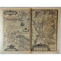
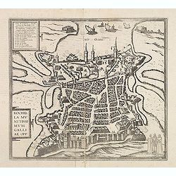
Rochella munitissimum galliae opp :
Town-plan of La Rochelle, with a numbered key (1-16) in the upper left corner gives the locations of the important buildings and landmarks.From volume II of Braun and Hog...
Date: Cologne, ca. 1574
Selling price: ????
Please login to see price!
Sold in 2011
Rochella munitissimum galliae opp :
Town-plan of La Rochelle, with a numbered key (1-16) in the upper left corner gives the locations of the important buildings and landmarks.From volume II of Braun and Hog...
Date: Cologne, ca. 1574
Selling price: ????
Please login to see price!
Sold in 2012
Gallia Nova Tabula.
Early map showing parts of France, Belgium, Luxembourg, Germany, Switzerland, Cornwall, and the Ligurian coast with Genoa and Milan. Engraved with mountains and rivers wi...
Date: Venice, c1574
Selling price: ????
Please login to see price!
Sold in 2013
Die statt Montpellier . . .
Panoramic view of Montpellier by Sebastian Münster. Title and a description of the city on verso. With a lettered key underneath the engraving. From the German edition o...
Date: Basel, 1574
Selling price: ????
Please login to see price!
Sold in 2019
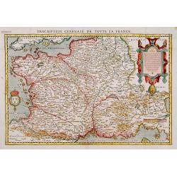
Description Générale de toute la France.
Detailed and uncommon wood block map of France after Ortelius, from François Belleforest's Paris version of Münster's cosmography : Histoire Universe du Monde ..
Date: Paris 1575
Selling price: ????
Please login to see price!
Sold
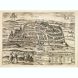
Bloys.
Early and detailed birds-eye town-view of Bloys. From the greatest publication in this genre!. The Civitates was compiled and written by George Braun, Canon of Cologne Ca...
Date: Cologne, 1575
Selling price: ????
Please login to see price!
Sold
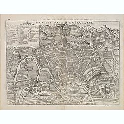
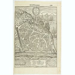
Le Vray pourtraict de la ville d'Aix en Provence.
A very decorative and rare town-plan of Aix en Provence from Franc¸ois de Belleforest's "La Cosmographie universelle de tout le monde". Paris, 1575. The book w...
Date: Nicolas Chesneau and Michel Sonnius, Paris,1575
Selling price: ????
Please login to see price!
Sold in 2012
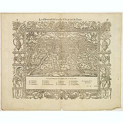
Le vif portaict de la noble ville, & cité de Tours.
Early bird's eye of Tours. In 1575 Sebastian Münster's Cosmographia was translated into French and published in Paris by François de Belle-Forest.
Date: Paris, 1575
Selling price: ????
Please login to see price!
Sold in 2012
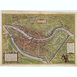
Lugdunum.
Bird's eye view of Lyon.
Date: Cologne, ca. 1575
Selling price: ????
Please login to see price!
Sold in 2014
Augustodunum Flauia Heduorum.
A fine engraved view of the city of Autun, in France, on the Loire River. Taken from the Latin edition of George Braun and Frans Hogenberg's landmark "Civitates Orbi...
Date: Cologne, 1575
Selling price: ????
Please login to see price!
Sold in 2017
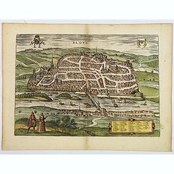
Bloys.
An early and detailed birds-eye town-view of Bloys. From the greatest publication in this genre!. The Civitates was compiled and written by George Braun, Canon of Cologne...
Date: Cologne, 1575
Selling price: ????
Please login to see price!
Sold in 2020
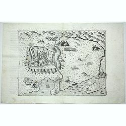
La ville et Chasteau de Nice.
A rare and early woodcut view of Nice in the Provence, published in "La Cosmographie Universelle de tout le monde", A French version of Sebastian Münster's Cos...
Date: Paris, Nicolas Chesneau, Michel Sonnius, 1575
Selling price: ????
Please login to see price!
Sold in 2019
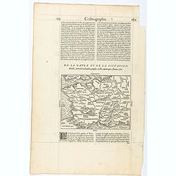
Page from La Cosmographie Universelle with map of France. (Page 160)
Text page with woodblock map of ancient France (122 x 163 mm.) In 1575 Sebastian Münster's Cosmographia was translated into French and published in Paris by François d...
Date: Paris, 1575
Selling price: ????
Please login to see price!
Sold in 2025
Blâmont. - Blanmont au Pays de Vauge en Loreyne.
Decorative early panoramic view of Blâmont by Braun and Hogenberg .From the second volume of Braun & Hogenberg's "Civitas Orbis Terrarum. " Latin text to v...
Date: Cologne, 1575
Selling price: ????
Please login to see price!
Sold in 2021
Besançon, - Vesontionis Antiquissimae Celeberrimaeq Sequanorum qui in Celtica Gallia Burgundiae Comitatus Nomine Censentur Metropolis Imperialisq Civitatis delineatio.
A fine antique map - bird's-eye view of Besançon, by Braun and Hogenberg, from the: Civitates Orbis Terrarum, ... Part 2. Köln, 1575. CAPTION: The Sequani called thi...
Date: Cologne, 1575
Selling price: ????
Please login to see price!
Sold in 2022
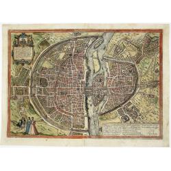
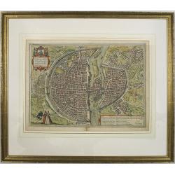
Paris
One of the earliest and most beautiful panoramic views of Paris, based on Sebastian Muenster’s map from 1569. Latin title in cartouche top-left and French title in a ca...
Date: Cologne, 1575
Selling price: ????
Please login to see price!
Sold in 2022
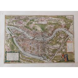
Lugdunum
Fine bird's-eye view plan of Lyons, with excellent detail of the city and its surroundings. Decorated with a finely dressed man and woman in foreground and two strapwor...
Date: Cologne, c1575
Selling price: ????
Please login to see price!
Sold in 2023
![Monsiessulanus, Montpellier [on sheet with] Turo, Tours [and] Pictavis, sive Pictavia, Vernaculo Idiomate Poitiers.](/uploads/cache/33647-250x250.jpg)
Monsiessulanus, Montpellier [on sheet with] Turo, Tours [and] Pictavis, sive Pictavia, Vernaculo Idiomate Poitiers.
Three very desirable and early town-views of Montpellier, Tours and Poitiers.Montpellier: With key to locations. In his brief description of the city, Braun focuses prima...
Date: Cologne, (1572) 1577
Selling price: ????
Please login to see price!
Sold in 2015
![Rotomagus, vulgo Roan, Normandiae Metropolis [on sheet with] Nemavsus, Nismes, Civitas Narbonensie Galliae Vetustissima [and] Civitas Burdegalensis in Aquitanea, Genuina Descrip.](/uploads/cache/33648-250x250.jpg)
Rotomagus, vulgo Roan, Normandiae Metropolis [on sheet with] Nemavsus, Nismes, Civitas Narbonensie Galliae Vetustissima [and] Civitas Burdegalensis in Aquitanea, Genuina Descrip.
Three very desirable and early town-views of Rouen, Nîmes and Bordeaux.Montpellier: With key to locations. In his brief description of the city, Braun focuses primarily ...
Date: Cologne, (1572) 1577
Selling price: ????
Please login to see price!
Sold in 2014
Argentoratum, cuius ob antiquitatem Ptolemeus. . .
Very desirable and early town-plans of Strasbourg in a first state. "Strasbourg is seen from a bird's-eye perspective in a plan view in which the blocks of houses ar...
Date: Cologne, (1572) 1577
Selling price: ????
Please login to see price!
Sold in 2016
Von der Statt Cales.
Very attractive and detailed birds-eye plan of Calais, France showing the full extent of rivers and moated fortification. It is set in a page of Old German text with text...
Date: Basel, 1578
Selling price: ????
Please login to see price!
Sold in 2017
Picardiae, Belgicae regionis descriptio. Joanne Surhonio auctore
Beautiful original old colored map of the Picardie region in Northwest France by Abraham Ortelius. Showing the Picardy from the sea to Abbeville, Amiens and Laon in the e...
Date: Antwerp, 1579
Selling price: ????
Please login to see price!
Sold in 2009
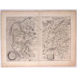
Anjou. Andegavensium Ditionis Vera et Integra Descriptio
Beautiful map of the Anjou region of western France along the Loire River. Include the city of Angers in the center. Accompanying text on verso
Date: Antwerp, 1579
Selling price: ????
Please login to see price!
Sold in 2010
Anjou : Andegavensium ditionis vera et integra descriptio.
Attractive map of the Loire River valley centred on Angers. The map displays the river system with mountains and forests and hundreds of tiny villages. Large strapwork t...
Date: Antwerp, 1579
Selling price: ????
Please login to see price!
Sold in 2015
Matiscona vulgo Mascon../ Perpignan/ Chaumont
Bird's-eye view of Macon from his town book.From the greatest publication in this genre!. The "Civitates" was compiled and written by George Braun, Canon of Col...
Date: Cologne 1580
Selling price: ????
Please login to see price!
Sold
De Germania Colmariensis ciuitatis & circumiacentis agri pictura ad uiuum expressa.
Early bird\'s eye view of Colmar. From a French text edition of S. Münster\'s Cosmographia, which was a complete summary of Renaissance knowledge.
Date: Basle, 1550-1580
Selling price: ????
Please login to see price!
Sold in 2009
Lutetia Parisiorum urbs, toto orbe celeberrima notissimaque, caput regni Franciae.
Early bird\'s eye view of Paris, called at the time Lutetia. From a French text edition of S. Münster\'s Cosmographia, which is a short and complete summary of Renaissan...
Date: Basle, 1550-1580
Selling price: ????
Please login to see price!
Sold in 2008
![Caletensium Et Bononiensium Ditionis Accurata Delineatio [with] Veromanduorum Eorum Que Confinium Exactissima Descriptio.](/uploads/cache/91526-250x250.jpg)
Caletensium Et Bononiensium Ditionis Accurata Delineatio [with] Veromanduorum Eorum Que Confinium Exactissima Descriptio.
Two finely detailed maps by Ortelius. The map on the left shows the Belgian and French Coastal regions, while the map on the right focuses on a small region surrounding S...
Date: Antwerp, ca. 1580
Selling price: ????
Please login to see price!
Sold in 2010
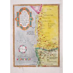
Old antique map of Narbonne Marseille- GAL / LIAE / NARBO / NENSIS / ORA MA / RITTIMA / / Recenter / descriptio.
Abraham Ortelius(1527-98), Dutch cartographer and publisher of the first modern atlas, ' Theatrum Orbis Terrarum' in 1570. Editions till 1612. Also an atlas of ancient ca...
Date: Antwerp, 1580
Selling price: ????
Please login to see price!
Sold in 2020
Caletensium et Bononiensium.. / Veromandorum. . .
Two maps on one sheet. Left map, entitled Caletensium, depicts the French and Belgian coastline from Estables to Calais. The right map, entitled Veromandorum, depicts the...
Date: Antwerp, 1580
Selling price: ????
Please login to see price!
Sold in 2016
Metz Antiqua et Precipue Belgra Urbs.
A rare early miniature view of Metz by an Italian engraver Francesco Valegio. From the'Nuova raccolta di le piu illustri et famose citta di tutto mondo' by Francesco Vale...
Date: Venice, 1580
Selling price: ????
Please login to see price!
Sold in 2017
Schletstatt erwan ein Dorff des Heiligen Römischen Reichs.
Woodcut. A topographical map of the imperial city of SELESTAT or Schletstad in the province of Alsace, France. Published by Münster in the German edition of “Cosmogra...
Date: Basel, 1580
Selling price: ????
Please login to see price!
Sold in 2016
Rochella Munitissimum Galliae Opp.
A fine example of the plan of La Rochelle, with its defensive fortifications. From the greatest publication in this genre!. The plates from Georg Braun and Frans Hogenber...
Date: Cologne, 1580
Selling price: ????
Please login to see price!
Sold in 2022
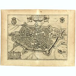
La Ville de Cambray.
Bird's eye view with citadel. - From the greatest publication in this genre!. The Civitates was compiled and written by George Braun, Canon of Cologne Cathedral. Braun ga...
Date: Cologne, 1580
Selling price: ????
Please login to see price!
Sold in 2020
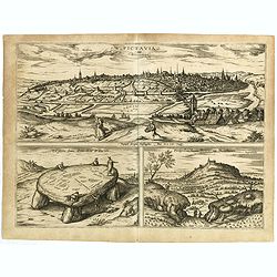
Pictavia vulgo Poictiers / La pierre leuee demie lieue de Poictiers / Prospectus Montis Henrici vulgo Montherri.
Bird's-eye view of Nocera Umbra and Castelnuovo. - From the greatest publication in this genre!. The Civitates was compiled and written by George Braun, Canon of Cologne ...
Date: Cologne, 1580
Selling price: ????
Please login to see price!
Sold in 2019
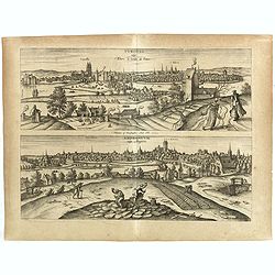
Tvrones vulgo Yours le jardon de France / Andegavvm vulgo Angiers.
Two decorative views on one double page. - From the greatest publication in this genre!. The Civitates was compiled and written by George Braun, Canon of Cologne Cathedra...
Date: Cologne, 1580
Selling price: ????
Please login to see price!
Sold in 2018
