Browse Listings in Europe
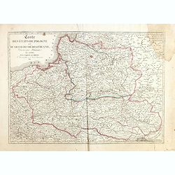
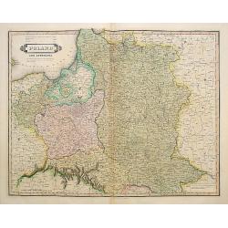
Carte des Etats de Pologne et du Grand Duché de Lithunanie.
Uncommon map of Poland prepared by Eustache Hérisson (1759-18.. ) and engraved by Cordier. The map was published by the last family member of the Jean publishing firm of...
Date: Paris, 1831
Selling price: ????
Please login to see price!
Sold in 2015
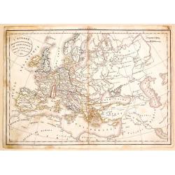
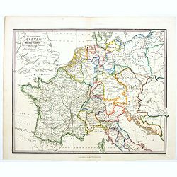
L'Europe a l'Epoque du Demembrement de L'Empire de Charlemagne.
Fine map featuring the empire of CHARLEMAGNE in Europe. It was developed by F. Delamarche in Paris in 1831. It was published in "ATLAS DE LA GEOGRAPHIE".
Date: Paris, 1831
Selling price: ????
Please login to see price!
Sold in 2017
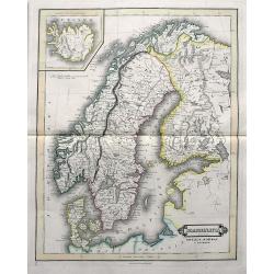
Scandinavia including Sweden, Norway & Denmark.
An excellent steel engraved map of Scandinavia, including the Baltics and St. Petersburg. An inset map shows Iceland.
Date: Edinburgh, ca 1831
Selling price: ????
Please login to see price!
Sold in 2019
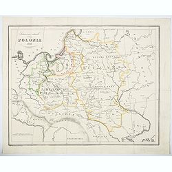
Situazione attuale della Polonia 1831.
An unusual map of Poland by the Italian Bernardo Zaydler, published in the work History of Poland in 1831. The map extends from Prussia and Bohemia in the west, across th...
Date: Florence, 1831
Selling price: ????
Please login to see price!
Sold in 2023
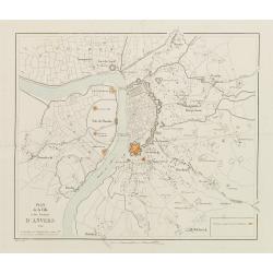
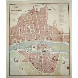
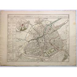
Plan de la Ville et des Environs d'Anvers.
Bird-eye view of Antwerp. Engraved by van Em. The positions occupied by the Dutch are marked in red.
Date: Bruxelles 1832
Selling price: ????
Please login to see price!
Sold
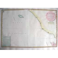
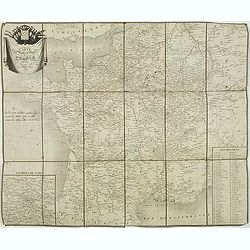
CARTE DES CÔTES DE FRANCE PARTIE COMPRISE ENTRE L'ILE D'YEU ET LA POINTE DES BALEINES
Highly decorative and very rare large-scale engraved seachart of the French coast from Ile de Ré until Ile d'Yeu, engraved by Collin. Includes Jard, Les Sables D'Olonne,...
Date: Paris, 1832
Selling price: ????
Please login to see price!
Sold in 2010
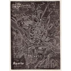
Oporto.
A distinctive woodblock engraved map of Oporto where the printing is reversed - white on black. The map was published in London in 1832 in William Pinnock's "The Gui...
Date: London, 1832
Selling price: ????
Please login to see price!
Sold in 2012
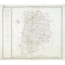
Departement de Seine et Marne. . .
Map centred of Rosoy and Fontainebleau. Borders of the district are colored. Map showing the city Nemours, Melun, Meaux, etc. In the left margin a cartouche with the list...
Date: Paris, 1832
Selling price: ????
Please login to see price!
Sold
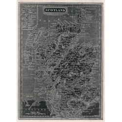
Scotland.
A distinctive woodblock engraved map of Scotland where the printing is reversed - white on black. The map was published in London in 1832 in William Pinnock's "The ...
Date: London, 1832
Selling price: ????
Please login to see price!
Sold in 2012
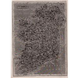
Ireland.
A distinctive woodblock engraved map of Ireland where the printing is reversed - white on black. The map was published in London in 1832 in William Pinnock's "The Gu...
Date: London, 1832
Selling price: ????
Please login to see price!
Sold in 2012
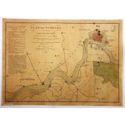
Plan der Schelde van Boven Antwerpen...
Plan of Schelde from Antwerp to the village of Doel: with the position of our ship force at the resumption of hostilities against the Belgians, on August 3, 1831.By F. Ka...
Date: Amsterdam, 1832
Selling price: ????
Please login to see price!
Sold in 2018
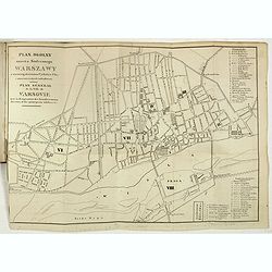
Plan I Obraz Warszawy. Plan et Panorama de Varsovie.
Very rare bi-bilingual (Polish and French) street guide to Warsaw prepared by Jan Glücksberg (1784-1859). This rare publication starts with 10 pp of description of the t...
Date: Warsovie, 1832
Selling price: ????
Please login to see price!
Sold in 2019
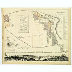
Pompeii.
A delightful example of the 1832 first edition S.D.U.K. plan of Pompeii, Italy. Pompeii was utterly destroyed by the eruption of the volcano Mt. Vesuvius, in A.D. 79 and ...
Date: London, 1832
Selling price: ????
Please login to see price!
Sold in 2019
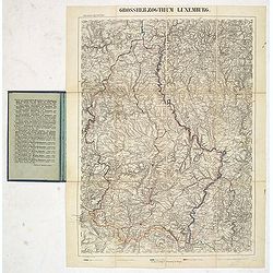
Grosserzogthum Luxemburg.
Steel engraved folding map of Luxembourg prepared by Reymann. With key in hand color to borders with Trier, France, Belgium, and Luxembourg.Reymann's Karte or Reymann'sch...
Date: Glogau, ca. 1832
Selling price: ????
Please login to see price!
Sold in 2019
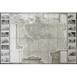
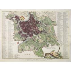
Pianta della Citta di Roma...
Decorative large-scale map of Rome with 16 vignette views showing St. Peters Basilica, the Pantheon, Colliseum, Forum Romano, etc. The map depicts the city within the wal...
Date: Rome, 1832
Selling price: ????
Please login to see price!
Sold in 2019
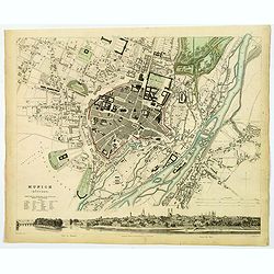
Munich (Munchen).
This is a beautiful first edition map of the German city of Munich, issued in 1832 by the Society for the Diffusion of Useful Knowledge, or S.D.U.K. It depicts the city a...
Date: London, 1832
Selling price: ????
Please login to see price!
Sold in 2020
The Central Part of Europe for the Elucidation of the Abbe Gaultier's Geographical Games.
A detailed map of central Europe from A Complete Course of Geography, by Means of Instructive Games invented by the Abbé Gaultier included ‘numerous emendations and ad...
Date: London, 1832
Selling price: ????
Please login to see price!
Sold in 2020
Poland and Lithuania.
Uncommon detailed steel engraved map of Poland and Lithuania. Published in Edinburgh by W. Lizars.
Date: Edinburgh, 1833
Selling price: ????
Please login to see price!
Sold in 2008
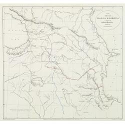
Part of Georgia & Armenia to illustrate Colonel Monteith's journal.
Uncommon map of the Caucasus of Monteith's who was a British Army colonel's travels at a time of Russian expansion in the region. Showing the Black Sea to the Caspian sea...
Date: London, 1833
Selling price: ????
Please login to see price!
Sold in 2010
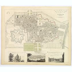
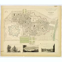
Turin (Torino).
A detailed map of the north Italian city of Turin, published by the Society for the Diffusion of Useful Knowledge. The Society was founded by John, Earl Russell, and Henr...
Date: London, 1833
Selling price: ????
Please login to see price!
Sold in 2018
Turin (Torino).
A detailed map of the north Italian city of Turin, published by the Society for the Diffusion of Useful Knowledge. The Society was founded by John, Earl Russell, and Henr...
Date: London, 1833
Selling price: ????
Please login to see price!
Sold in 2019
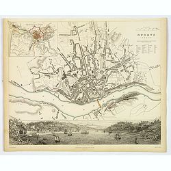
Oporto.
An appealing plan of the second largest Poruguese city of Oporto, famed for giving its name to Port wine. There is a detailed town plan, plus a small table of notes to as...
Date: London, 1833
Selling price: ????
Please login to see price!
Sold in 2019
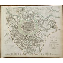
VIENNA - WIEN
Drawn by W. B. Clarke engraved by J. Henshall 1833 first edition. A very attractive and detailed mid-19th century plan of Vienna, Austria which was published under the Su...
Date: London 1833
Selling price: ????
Please login to see price!
Sold in 2019
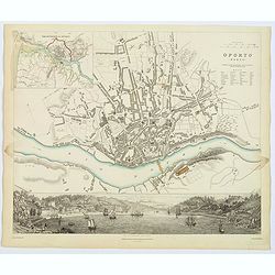
Oporto.
An appealing plan of the second largest Portuguese city of Oporto, famed for giving its name to Port wine. There is a detailed town plan, plus a small table of notes to a...
Date: London, 1833
Selling price: ????
Please login to see price!
Sold in 2020
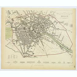
Berlin.
This delightful plan of Berlin has architectural elevations of principal public buildings at its foot. Berlin was capital of the Kingdom of Prussia, Austria’s rival as ...
Date: London, 1833
Selling price: ????
Please login to see price!
Sold in 2019
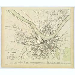
Dresden.
This delightful plan of Dresden, the capital city of the German region of Saxony. It has architectural elevations of principal public buildings at its foot. This plan sho...
Date: London, 1833
Selling price: ????
Please login to see price!
Sold in 2020
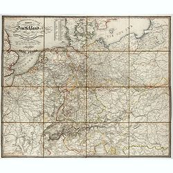
General- Post- und Reis-carte von Deutschland und den Nachbarländern bis Paris... / Carte générale et routière de l'Allemagne et des pays limitrophes jusqu'à Paris...
Road map of Germany and neighboring countries reaching as far as Paris, London, Copenhagen, Warsaw and Boulogne, compiled from official materials and the most recent maps...
Date: Francfurt am Main, Charles Jugel, 1833
Selling price: ????
Please login to see price!
Sold in 2022
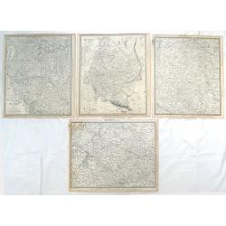
( 4 Large Maps ) Russia in Europe, Parts IV, V, VI & X.
Four maps featuring section (IV, V, VI & X) of "Russia in Europe" by S.D.U.K. and engraved by J & C Walker. Published by Baldwin & Craddock in Londo...
Date: London, 1834
Selling price: ????
Please login to see price!
Sold in 2018
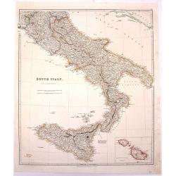
South Italy.
Large hand-colored, detailed map of SOUTHERN ITALY and SICILY, by Arrowsmith. Produced for "THE LONDON ATLAS OF UNIVERSAL GEOGRAPHY" by John Arrowsmith. Includ...
Date: London, 1834
Selling price: ????
Please login to see price!
Sold in 2016
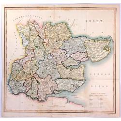
ESSEX
A large steel engraved map labelled "Essex", engraved by James Bingley, published in Virtue's “Picturesque Beauties of Great Britain” in London in 1834.
Date: London, 1834
Selling price: ????
Please login to see price!
Sold in 2016

Map of the County of OXFORD from an Actual Survey' by C. & J. Greenwood.
A very attractive and detailed 19th century map of Oxfordshire, replete with a fine vignette view of Oxford Cathedral, which was published in Christopher and John Greenwo...
Date: London, 1834
Selling price: ????
Please login to see price!
Sold in 2018
![[Title page] Nouvelle géographie et statistique de la France, Alger et la Belgique.](/uploads/cache/41675-250x250.jpg)
[Title page] Nouvelle géographie et statistique de la France, Alger et la Belgique.
Frontispiece with map of France with two sheets showing a mail exchanges between Henry and the rector, the prefect and the ministry of the public institution, plus a desc...
Date: Paris, 1834
Selling price: ????
Please login to see price!
Sold in 2020
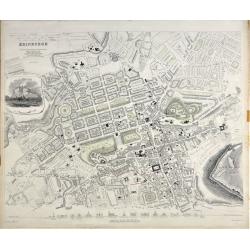
Edinburgh.
A beautiful plan of the city of Edinburgh, Scotland by the Society for the Diffusion of Useful Knowledge. Centred on the Old Town, it covers the city of Edinburgh in exce...
Date: London, 1834
Selling price: ????
Please login to see price!
Sold in 2020
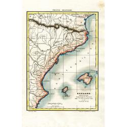
Espagne Orientale Comprenant les Provinces de Catalogne et de Valence
Attractive and unusual steel engraved map showing the eastern part of Spain with Barcelona, Valencia, and the Balearic Islands of Ibiza, Mallorca, and the tip of Menorca....
Date: Paris, c1835
Selling price: ????
Please login to see price!
Sold in 2008
Carte de la Campagne de l'Armée D'Italie en 1809
Attractive and unusual steel engraved map illustrates the military activities in Austria, Hungary, and the Istria peninsula in 1809, during the Franco-Italian Napoleon fo...
Date: Paris, c1835
Selling price: ????
Please login to see price!
Sold in 2008
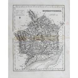
(Lot of 2 maps) Wales - Monmouthsthire
An interesting pair of old maps of Wales: - Fullarton, ca. 1835, "Monmouthshire". 240 x 190 mm. A detailed map with much information, showing also the distance...
Date: England, c1835
Selling price: ????
Please login to see price!
Sold in 2012
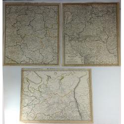
Three S.D.U.K. Maps - Russia II, Russia V & Russia VI
Three detailed maps of Russia by S.D.U.K. published in London in 1835 by Chapman & Hall. “Russia II” covers Olonetz, Iaroslav, Arkhangel, Vologda, Viarka & Pe...
Date: London, 1835
Selling price: ????
Please login to see price!
Sold in 2016
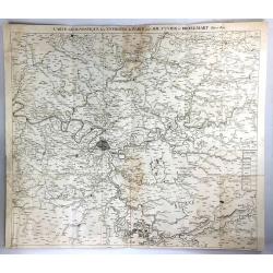
Carte Geognostique des Environs de Paris
A large detailed map from "Memoires de la Classe des Sciences Mathematiques et Physiques de l`Institut Imperial de France", by Cuvier & Brongniart, publishe...
Date: Paris, 1835
Selling price: ????
Please login to see price!
Sold in 2016
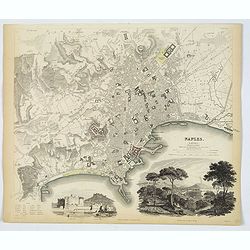
Naples.
An attractive town plan of Naples, a pair of handsome decorative vignette views of 'Naples from the Hill of Posilipo' and the 'New Castle and Castle St. Elmo'. Plan is ve...
Date: London, 1835
Selling price: ????
Please login to see price!
Sold in 2019
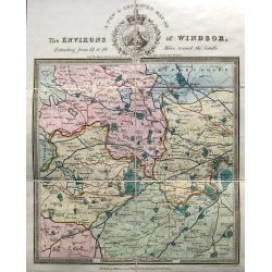
A new & improved map of the environs of Windsor, extending from 14 to 18 miles round the castle.
An apparently very scarce map (Copac with only 2 listings) of the area around Windsor. The map includes roads and distances. The title with a decorative vignette. Drawn ...
Date: London, ca. 1835
Selling price: ????
Please login to see price!
Sold in 2023
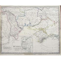
Russia in Europe Part VIII.
An early example of this interesting large scale map. Shows a part of the Black Sea with the Crimea, the Danube Delta, parts of Romania, Moldova, and the Ukraine. Include...
Date: London, 1835
Selling price: ????
Please login to see price!
Sold in 2019
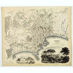
Naples.
An attractive town plan of Naples, a pair of handsome decorative vignette views of 'Naples from the Hill of Posilipo' and the 'New Castle and Castle St. Elmo'. Plan is ve...
Date: London, 1835
Selling price: ????
Please login to see price!
Sold in 2019
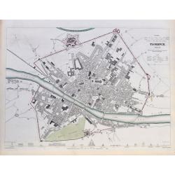
Florence. Firenze.
A highly detailed town plan of Florence, with profile views of 16 principal buildings. With street names, buildings, piazzas, the castello, etc.Drawn by W. B. Clarke, eng...
Date: London, 1835
Selling price: ????
Please login to see price!
Sold in 2020
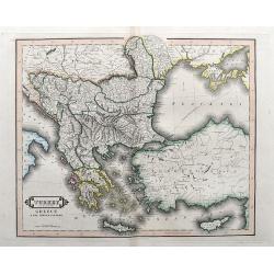
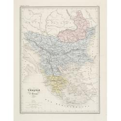
Turkey in Europe, Greece & the Ionian Islands.
A scarce and a highly detailed map of Turkey and Greece. Includes the Balkans, Cyprus, Crimea and the Black Sea. An attractive example.
Date: Edinburgh, ca 1835
Selling price: ????
Please login to see price!
Sold in 2020
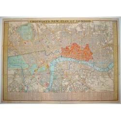
Cruchley's New Plan of London Shewing all the New and Intended Improvements to the Present Time
One of the more desirable and sought after plans of London. Demand for Cruchley London plans has grown substantially in recent years. At a 2006 Bonhams auction, an 1828...
Date: London, 1836
Selling price: ????
Please login to see price!
Sold
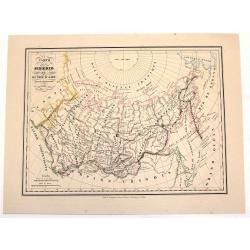
Carte de la Siberie ou Russie D'Asie.
An interesting hand-colored, lithograph map of Siberia from the Brussels edition of Malte-Brun's "Atlas Complet." The way that the provinces or Oblasts are diff...
Date: Brusselles, 1836
Selling price: ????
Please login to see price!
Sold in 2013
Map of the Canals and Navigable Rivers in England, Wales and Scotland. . .
From The History of Lancashire by Edward Baines, engraved by Hall, and by William Swire, Surveyor, Leeds. Shows all of England and Wales and Scotland as far north as Pert...
Date: Leeds, 1824-1836
Selling price: ????
Please login to see price!
Sold in 2021
Carte physique et minéralogique de la France.
Thematical map of France with inset map of Corsica and Paris.From Malte-Brun's Atlas Géographie Universelle.."., revised by Jean Jacques Nicolas Huot.This...
Date: Paris 1837
Selling price: ????
Please login to see price!
Sold
Allemagne centrale.
"Map of Germany.From Malte-Brun's Atlas Géographie Universelle..""., revised by Jean Jacques Nicolas Huot.This very fine executed map has been p...
Date: Paris 1837
Selling price: ????
Please login to see price!
Sold
Éspagne Ancienne.
Detailed map of ancient Spain and Portugal.From Malte-Brun's Atlas Géographie Universelle.., revised by Jean Jacques Nicolas Huot.This very fine executed map has been pr...
Date: Paris 1837
Selling price: ????
Please login to see price!
Sold
Plan de la Ville de Paris, sous Phillipe de Bel...
An uncommon, large scale, decorative early 19th century plan of Paris. The work was commissioned by architect Albert Lenoir. Important buildings are highlighted and stree...
Date: Paris, 1837
Selling price: ????
Please login to see price!
Sold
Turquie d' Europe. (Greece)
Detailed map of Greece.From Malte-Brun's Atlas Géographie Universelle.. ., revised by Jean Jacques Nicolas Huot.This very fine executed map has been printed by Fosset an...
Date: Paris, 1837
Selling price: ????
Please login to see price!
Sold in 2013
Europe aprés l'invasion des Barbares..
Ancient map of Europe in the 5th and 6th century.From Malte-Brun's Atlas G�ographie Universelle.., revised by Jean Jacques Nicolas Huot.This very fine executed map h...
Date: Paris 1837
Selling price: ????
Please login to see price!
Sold in 2008
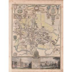
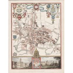
'CITY AND UNIVERSITY OF OXFORD'.
A highly detailed, finely engraved, hand colored plan of the University City of Oxford, embellished with the heraldic shields, arms of the Town, the University, and its c...
Date: London, 1837
Selling price: ????
Please login to see price!
Sold in 2019
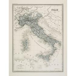
Italie.
Fine map of Italy.From Malte-Brun's Atlas Géographie Universelle.. ., revised by Jean Jacques Nicolas Huot.This very fine executed map has been printed by Fosset and was...
Date: Paris, 1837
Selling price: ????
Please login to see price!
Sold in 2011

(Title page) Album venitien composé de douze vues. . .
Beautiful title page from "Album venitien composé de douze vues" with in center Venice's famous Bridge of Sighs, which was designed by Antonio Contino and was ...
Date: Venice, J. Kier, 1837
Selling price: ????
Please login to see price!
Sold in 2019
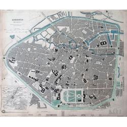
Brussels (Bruxelles)
Highly detailed town plan of Brussels, with profile views of 8 principal buildings and a smaller map of the environs of Brussels. With street names, buildings, parks, etc...
Date: London, 1837
Selling price: ????
Please login to see price!
Sold in 2011
'CITY AND UNIVERSITY OF OXFORD'
A steel engraving by James Bingley in 1837 for Moule's "English Counties Delineated" The 1830 -1837 editions of this map are scarce.An attractive and highly det...
Date: London, 1837
Selling price: ????
Please login to see price!
Sold in 2016
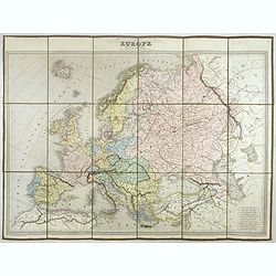
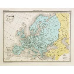
EUROPE Dressée par C.V. Monin.
Detailed map of Europe with different scales in lower right corner.Engraved by L.Grenier, Rue des Noyers, No. 33. and printed by Mangeon.Here the map is issued as a singl...
Date: Paris, Armand Aubrée, ca. 1837
Selling price: ????
Please login to see price!
Sold in 2017
Plan de Bruxelles et de ses Faubourgs.
A very detailed city plan of Brussels and its suburbs, with a route map of its surroundings and postal routes from Brussels to The Hague.The map was produced by J.B.D.B a...
Date: Paris, 1837
Selling price: ????
Please login to see price!
Sold in 2017
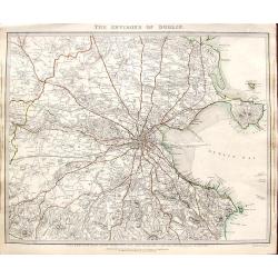
The environs of Dublin.
A very detailed map of the region surrounding Dublin, extending to Killiney Bay, Muldouny Bay and County Kildare. The map also locates churches, lodges, parks, roads, etc...
Date: London, 1837
Selling price: ????
Please login to see price!
Sold in 2018

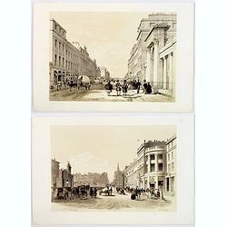
The Trongate, Glasgow. . .
An attractive tinted lithograph from a folio of some 26 tinted litho's, titled Sketches in Scotland, Drawn on Stone from Nature. by Samuel Swarbreck. Signed, dated and ti...
Date: London, 1837
Selling price: ????
Please login to see price!
Sold in 2020
(Two prints) North Bridge Street Edinburgh / The Regents Bridge, Waterloo Place, Edinburgh.
An attractive pair of tinted lithograph of Edinburgh street scenes from a folio of some 26 tinted litho's, titled Sketches in Scotland, Drawn on Stone from Nature. by Lon...
Date: London, 1837
Selling price: ????
Please login to see price!
Sold in 2019

Holyrood Palace & Chapel with Arthur's Seat and Salisbury Crags.
A fine Edinburgh lithograph entitled “Holyrood Palace And Chapel With Arthur’s Seat And Salisbury Crags ” by the London-born artist Samuel Swarbreck. It dates from ...
Date: London, 1837
Selling price: ????
Please login to see price!
Sold in 2018
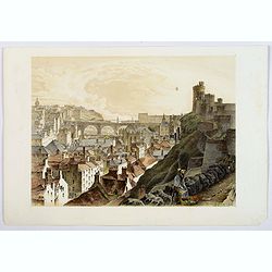
The North Bridge & part of the New & Old Towns of Edinburgh.
A fine Edinburgh lithograph showing the historic North Bridge, linking the New and Old Towns of Edinburgh, by the London-born artist Samuel Swarbreck. It dates from 1837 ...
Date: London, 1837
Selling price: ????
Please login to see price!
Sold in 2018
Pianta topografica della citta di Roma.
Uncommon and decorative plan of Rome. With a numbered key. 1-264. Engraved by Marco di Pietro.
Date: Florence 1838
Selling price: ????
Please login to see price!
Sold
Carte des routes de poste de France dressée par Tardieu Graveur 1838.
This post road maps map of France is showing incredible detail of the postal roads, stations (or "stages"), and the distances from town to town. Lower left an i...
Date: Paris, 1838
Selling price: ????
Please login to see price!
Sold
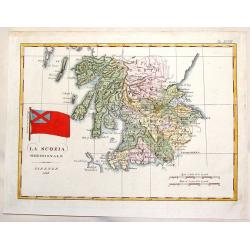
La Scozia Meridionale.
Striking Marmocco map with his signature map (Southern Scotland) added. Francesco Costantino Marmocchi (1805 - 1858 ) was an Italian geographer . His other writings de...
Date: Florence, 1838
Selling price: ????
Please login to see price!
Sold in 2014
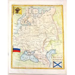
Russia Europa.
Pleasing map of Russia with three pertinant flags. Includes Russian flag as well as flags of war and mercantile marine. The flags covers Russia, poland, Lithuania, Estoni...
Date: Florence, 1838
Selling price: ????
Please login to see price!
Sold in 2013
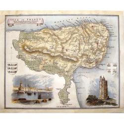
Isle of Thanet.
Decorative map oF the Island of Thanet, Kent with two views and 2 coats of arms. This is a map from "ENGLISH COUNTIES DELINEATED" by Thomas Moule who combined a...
Date: London, 1838
Selling price: ????
Please login to see price!
Sold in 2014
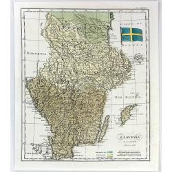
La Svezia e la Gotia.
A fine map of Sweden by Francesco Constantino Marmocchi. It is from the atlas "Atlante di Geogrfia Universale" published in Florence in 1838. The map features a...
Date: Florence, 1838
Selling price: ????
Please login to see price!
Sold in 2016
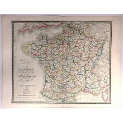
The Kingdom of France describing the New Limits according to the Treaty of Paris.
A large, beautifully detailed, and colorful map of France divided into 86 departments, with Corsica as an inset. No cartouche but very decorative calligraphy in the title...
Date: London, 1838
Selling price: ????
Please login to see price!
Sold in 2016
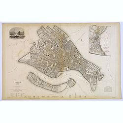
Venice.
A lovely steel engraved plan of Venice by the Society for the Diffusion of Useful Knowledge (SDUK). This English philanthropic enterprise was entirely devoted to the spre...
Date: London, 1838
Selling price: ????
Please login to see price!
Sold in 2018
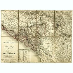
Carte du pays de Montenegro dressée d'après les opérations géodétiques . . .
A rare map of Montenegro, prepared by Mr. le Comte Fedor de Karacsay (1787-1859) and engraved by Pietro Allodi. The title is in Russian, Arabic, and French.In the lower-l...
Date: Vienna, ca. 1838
Selling price: ????
Please login to see price!
Sold in 2018
Europe - Mars 1839
Fine manuscript map of Europe with relief shown pictorially. The Oceans in wash color and the borders in different colors. Dated 1839 and signed by the author in the lowe...
Date: Paris, 1839
Selling price: ????
Please login to see price!
Sold in 2009
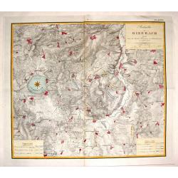
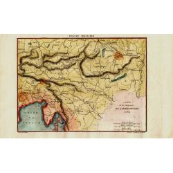
Batailles de Biberach Livrees Entre les Armees Francaises et Autricheinnes en 1796 et 1800.
Fine military map depicting the details of the battlefield of Biberach. It features fortifications and troop placements. Three plain block cartouches and unique compass r...
Date: Paris, 1839
Selling price: ????
Please login to see price!
Sold in 2015
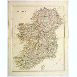
Ireland.
An attractive steel engraved map of Ireland, with each county divided by a different color. A pleasing amount of detail is provided. Also with a small inset map naming th...
Date: London, 1839
Selling price: ????
Please login to see price!
Sold in 2023
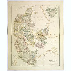
Denmark.
An attractive steel engraved map of Denmark, with an inset map of Iceland, which was then a Danish dependency. Many place names and physical features shown.The Arrowsmith...
Date: London, 1839
Selling price: ????
Please login to see price!
Sold in 2017
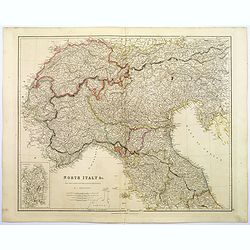
North Italy &c. . .
A large steel engraved map of Northern Italy, to include Switzerland, inset of the Italian Mediterranean island of Sardinia. Map extends as far south as the isle of Elba....
Date: London, 1839
Selling price: ????
Please login to see price!
Sold in 2017
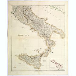
South Italy.
A large steel engraved map of South Italy, with an inset of the Maltese Islands. Map extends from Perugia, southward through Naples, continuing south to 'the boot', and i...
Date: London, 1839
Selling price: ????
Please login to see price!
Sold in 2020