Browse Listings in Europe
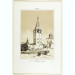
Tour de la Cathédrale d'Ouspensky.
A view of Ouspensky's cathedral. Figures are lithographed by Raffet. Plate taken from the first illustrated account of Russian architecture. This publication was the proj...
Date: Paris, 1844
Selling price: ????
Please login to see price!
Sold
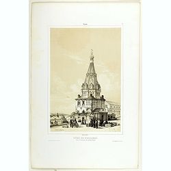
Dôme de Nikolskoï dans le Gastinnoï-dwor, (Grand Bazar).
A view of the Dome of Nikolskoï. Figures are lithographed by Raffet. Plate taken from the first illustrated account of Russian architecture. This publication was the pro...
Date: Paris, 1844
Selling price: ????
Please login to see price!
Sold in 2019

Cathédrale de la Nativite.
A view of the Nativité Cathedral. Figures are lithographed by Raffet. Plate was taken from the first illustrated account of Russian architecture. This publication was th...
Date: Paris, 1844
Selling price: ????
Please login to see price!
Sold in 2022

Monastère de Saint-Jean-Baptiste.
A view of Saint-Jean-Baptiste monastery, the 15 of September 1839. Figures are lithographed by Raffet. Plate taken from the first illustrated account of Russian architect...
Date: Paris, 1844
Selling price: ????
Please login to see price!
Sold
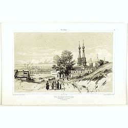
Vue de Nijni-Novgorod et du Monastère de l'annonciation.
A view of Nijni-Novgorod village, the 2 of September 1839. Figures are lithographed by Raffet. Plate taken from the first illustrated account of Russian architecture. Thi...
Date: Paris, 1844
Selling price: ????
Please login to see price!
Sold in 2019
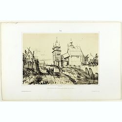
Chappelle et village de Tver.
A view of Tver village. Figures are lithographed by Raffet. Plate taken from the first illustrated account of Russian architecture. This publication was the project of Co...
Date: Paris, 1844
Selling price: ????
Please login to see price!
Sold in 2019
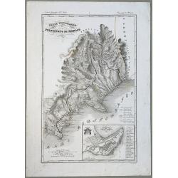
Carta Topografica del Principato Di Monaco.
A map of the Princedom of Monaco. Nice 19th Century map with insert at lower right: 'Topografia della Città Di Monaco', with legend 1-30. Original border-colored. From: ...
Date: Florence, 1844
Selling price: ????
Please login to see price!
Sold in 2020
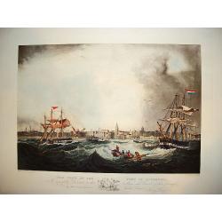
"This View of the Port of Liverpool..."
A large and impressive prospect of the city of Liverpool as seen from the port viewpoint. The ?active? nautical scene showing vessels in turbulent waters originates from ...
Date: Liverpool, ca. 1845
Selling price: ????
Please login to see price!
Sold
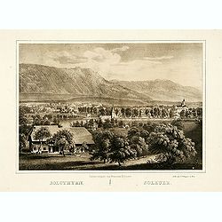
Solothurn.
"The lithography is made after a Daguerreotype by Franziska Möllinger. Lithographed by J. P. Wagner."
Date: Bern, 1845
Selling price: ????
Please login to see price!
Sold
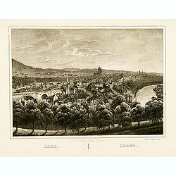
Bern.
The lithography is made after a Daguerreotype by Franziska Möllinger. Lithographed by J. P. Wagner.
Date: Bern, 1845
Selling price: ????
Please login to see price!
Sold in 2013
Cologne from the River.
An uncommon, nicely defined steel-plate view of Cologne as seen in the early-to-mid 1800s. The city's famous cathedral is shown. The river scene includes commercial barge...
Date: New York, ca. 1845
Selling price: ????
Please login to see price!
Sold in 2011
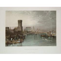
Cathédrale d'Isaac et Palais du Sénat. Vue prise de la Néva. (17 juillet 1839).
A view from the port of the Isaac Cathedral and the Senat Palace in Saint Petersburg on July 17 1839. Plate taken from the first illustrated account of Russian architectu...
Date: Paris, 1845
Selling price: ????
Please login to see price!
Sold in 2025
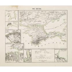
Die Krymm.
Uncommon map of Crimea and the area south of the Dnieper. Surrounded by six detailed inset plans of harbor towns (Sevastopol, Balaklava, Feodosia, etc) and a scale.
Date: Glogau, 1845
Selling price: ????
Please login to see price!
Sold in 2010
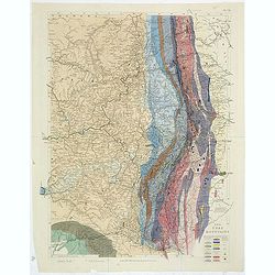
The Ural Mountains. Pl.VII.
A soil map of the Ural Mountains, with a color key in lower right corner. With very delicate original hand coloring.
Date: London,1845
Selling price: ????
Please login to see price!
Sold in 2011
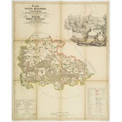
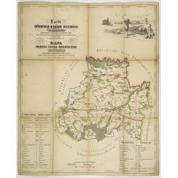
Karte des Euler Bezirkes im Prager Kreise zusammengestellt nach den neuesten und verlässchsten Quellen. . . / Mapa Okresu Jilovského v Prazskem kraji. . .
Uncommon folding map of Jilovského region. Printed in color lithography by J.Habel in Prague. Lithographed by J.Wagner. Decorative inset upper right of the Ringhoffer Ku...
Date: Prague, J.Habel, c 1845
Selling price: ????
Please login to see price!
Sold in 2013
Karte des Pürglitzer bezirkes im Prager- Kreise. . . / Mapa Okresu Krivoklatského v Prazkém kraji. . .
Uncommon folding map of Krivoklatského region. Printed in color lithography by J.Habel in Prague. Lithographed by Jan Ed. Wagner. Decorative inset upper right with a ret...
Date: Prague, J.Habel, c 1845
Selling price: ????
Please login to see price!
Sold in 2011
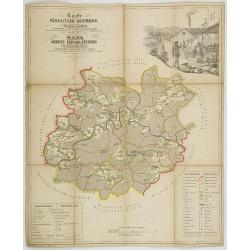
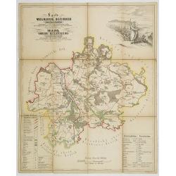
Karte des Welwarner Bezirkes im Prager Kreise zusammengestellt nach den neuesten und verlässchsten Quellen. . . / Mapa Okresu Velvarského v Prazskem kraji. . .
Uncommon folding map of Velvarského region. Printed in color lithography by J.Habel in Prague. Lithographed by J.Wagner. Decorative inset upper right of people harvestin...
Date: Prague, J.Habel, c 1845
Selling price: ????
Please login to see price!
Sold in 2011
Karte des Brandeiser Bezirkes im Prager Kreise zusammengestellt nach den neuesten und verlässchsten Quellen. . . / Mapa Okresu Brandýského v Prazskem kraji. . .
Uncommon folding map of Brandýského region. Printed in color lithography by J.Habel in Prague. Lithographed by J.Wagner. Decorative landscape upper right and key in low...
Date: Prague, J.Habel, c 1845
Selling price: ????
Please login to see price!
Sold in 2013
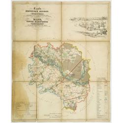
Karte des Böhmisch-Broder bezirkes im Prager- Kreise. . . / Mapa Okresu Cesko-Brodského v Prazkém kraji. . .
Uncommon folding map of Brodského region. Printed in color lithography by J.Habel in Prague. Lithographed by J.E.Wagner. Decorative landscape upper left with a hunting s...
Date: Prague, J.Habel, c 1845
Selling price: ????
Please login to see price!
Sold in 2011
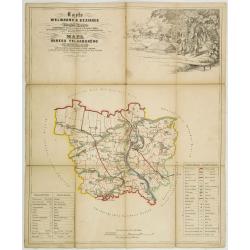
Karte des Melniker bezirkes im Prager- Kreise. . . / Mapa Okresu Mélnického v Prazkém kraji. . .
Uncommon folding map of Mélnického region with the rivers Moldova and the Elbe at Melník. Printed in color lithography by J.Habel in Prague. Lithographed by Jan Ed. Wa...
Date: Prague, J.Habel, c 1845
Selling price: ????
Please login to see price!
Sold in 2011
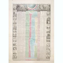
Tableau historique et chronologique du Royaume de Belgique ainsi que du Royaume Neerlandais depuis la plus haute antiquité jusqu'à nos jours
According to the text below, an "Nouvelle edition" of the decorative sheet giving a historical overview of the history of Belgium and events in the Netherlands.
Date: Paris, 1845
Selling price: ????
Please login to see price!
Sold in 2014
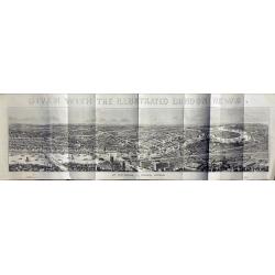
View of London.
Very large wood engraving printed and published as a supplement for the Illustrated London News, by William Little, London, January 11, 1845.
Date: London, 1845
Selling price: ????
Please login to see price!
Sold in 2014
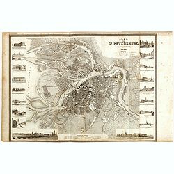
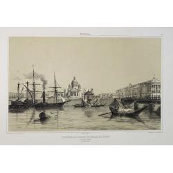
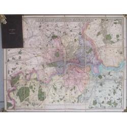
Plan von St. Petersburg.
Detailed plan of St. Petersburg features engraved vignettes of buildings throughout the great city, including a hospital, theater, library, bank, and churches. The title ...
Date: Hildburghausen, 1845
Selling price: ????
Please login to see price!
Sold in 2015
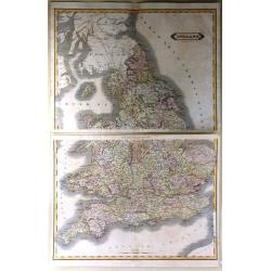
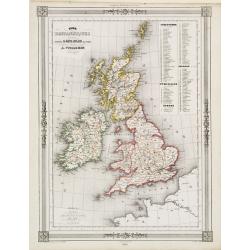
England
A very large map of England and Wales, focusing on the railway network constructed by W. H. Lizars from the most recent surveys, published by Lizars in Edinburgh in 1848....
Date: Edinburgh, 1845
Selling price: ????
Please login to see price!
Sold in 2016
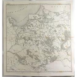
Carte du Pays Compris Entre la Vistule et la Pregel.
A map of Polish regions, including Warsaw, part of Russia and Danzig Bay, prepared by Dufour, and engraved by Ch. Dyonnet. It features the prominent cities of Gdansk (wri...
Date: Paris, 1845
Selling price: ????
Please login to see price!
Sold in 2019
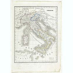
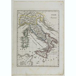
Italie.
Detailed map of Italy, prepared by Charles V. Monin (fl.1830-1880) a French cartographer of Caen and Paris. Published in Atlas Universel de Géographie Ancienne &c Mo...
Date: Paris, 1845
Selling price: ????
Please login to see price!
Sold in 2023
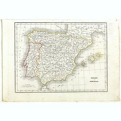
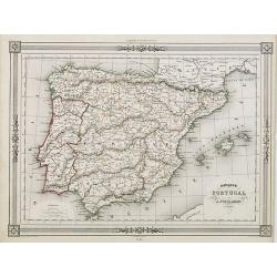
Espagne et Portugal.
Detailed map of Spain and Portugal, prepared by Charles V. Monin (fl.1830-1880) a French cartographer of Caen and Paris. Published in Atlas Universel de Géographie Ancie...
Date: Paris, 1845
Selling price: ????
Please login to see price!
Sold in 2019
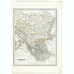
Turquie d'Europe.
Detailed map of European Turkey, including Greece, Romania, Bulgaria, Bosnie, etc. Prepared by Charles V. Monin (fl.1830-1880) a French cartographer of Caen and Paris. Pu...
Date: Paris, 1845
Selling price: ????
Please login to see price!
Sold in 2019
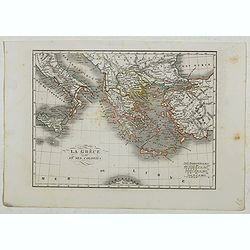
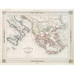
La Grèce et ses colonies.
Detailed map of Greece, prepared by Charles V. Monin (fl.1830-1880) a French cartographer of Caen and Paris. Published in Atlas Universel de Géographie Ancienne &c M...
Date: Paris, 1845
Selling price: ????
Please login to see price!
Sold in 2020
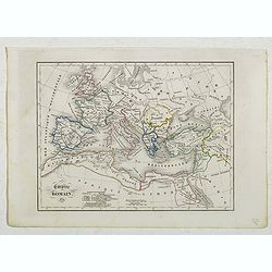
Empire Romain.
Detailed map of Europe and North Africa, prepared by Charles V. Monin (fl.1830-1880) a French cartographer of Caen and Paris. Published in Atlas Universel de Géographie ...
Date: Paris, 1845
Selling price: ????
Please login to see price!
Sold in 2022
Italie Ancienne.
Detailed map of Italy, prepared by Charles V. Monin (fl.1830-1880) a French cartographer of Caen and Paris. Published in Atlas Universel de Géographie Ancienne &c Mo...
Date: Paris, 1845
Selling price: ????
Please login to see price!
Sold in 2022
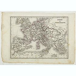
Empire de Charlemagne.
Detailed map of Europe, prepared by Charles V. Monin (fl.1830-1880) a French cartographer of Caen and Paris. Published in Atlas Universel de Géographie Ancienne &c M...
Date: Paris, 1845
Selling price: ????
Please login to see price!
Sold in 2022

London in Miniature With The Surrounding Villages. An Entire New Plan In which the Improvements both present and intended are actually reduced (by permission) from the surveys of the Several Proprietors ...
Folding plan of London showing the extents from Islington through to Camberwell and the River Lea to Kensington. Bright original color in block and outline. The plan diss...
Date: London: Edward Mogg, No. 14 Great Russell Street. January 1st, 1845
Selling price: ????
Please login to see price!
Sold in 2020
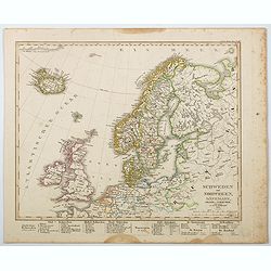
Schweden und Norwegen, Danemark, Island u. Faer-Oer. . .
A map of the northern Atlantic Ocean, centered on Scandinavia, the British Isles and Iceland published by Stieler in his 'Hand-Atlas.' Scandinavian region are listed belo...
Date: Gotha, 1845
Selling price: ????
Please login to see price!
Sold in 2021
![[Fortifications de Paris.]](/uploads/cache/48146-250x250.jpg)
[Fortifications de Paris.]
A lovely quite detailed plan of Paris published towards the middle of the 19th century. The plan identifies the various fortifications that surrounded the city. They are ...
Date: Paris, ca 1845
Selling price: ????
Please login to see price!
Sold in 2022
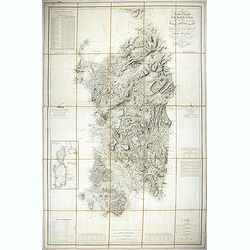
Carta dell isola e regno di Sardegna.
Considered the first map of Sardinia according to modern geodesic methods, it was realized thanks to the work of Alberto Ferrero della Marmora, later assisted by Majo...
Date: Paris and Torino, 1845
Selling price: ????
Please login to see price!
Sold in 2022
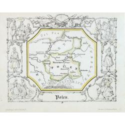
Polen.
Attractive lithograph map of Poland centered of Warschau. The map is surrounded with vignettes, presenting differents polish costumes. From : "Geographische Länder-...
Date: Berlin, 1846
Selling price: ????
Please login to see price!
Sold in 2013
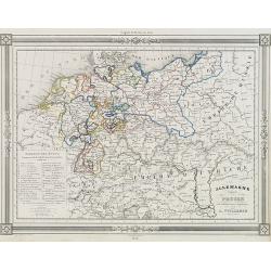
Allemagne.
Decorative map of Germany and Poland, prepared by J.G.Barbié du Bocage.Engraved by Ch.Smith, published by Basset who was established in Paris, rue de Seine 33. From atla...
Date: Paris, 1846
Selling price: ????
Please login to see price!
Sold in 2016
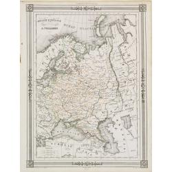
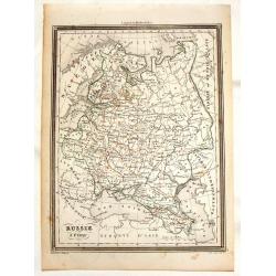
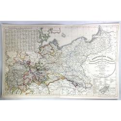
Russie d'Europe..
"Decorative map of Russia, prepared by J.G.Barbié du Bocage.Engraved by Ch.Smith, published by Basset who was established in Paris, rue de Seine 33. From ...
Date: Paris 1846
Selling price: ????
Please login to see price!
Sold
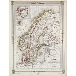
Chart of the Straits Between Denmark and Sweden Shewing the Passage from the Kattegat through
"Decorative map of Scandinavia, with inset map of Iceland and the Faeroe Islands, prepared by J.G.Barbié du Bocage.Engraved by Ch.Smith, published by Basset who was...
Date: Paris 1846
Selling price: ????
Please login to see price!
Sold
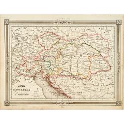
Empire d'Autriche..
Decorative map of Austria, prepared by J.G.Barbié du Bocage.Engraved by Ch.Smith, published by Basset who was established in Paris, rue de Seine 33. From atlas Illustré...
Date: Paris 1846
Selling price: ????
Please login to see price!
Sold
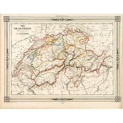
Carte de la Suisse..
Decorative map of Switzerland, prepared by J.G.Barbié du Bocage.Engraved by Ch.Smith, published by Basset who was established in Paris, rue de Seine 33. From atlas Illus...
Date: Paris, 1846
Selling price: ????
Please login to see price!
Sold in 2009
Espagne sous l'empire Romain.
Ancient map of Spain and Portugal, prepared by Auguste Henri Dufour (1798-1865). Published by Basset, rue de Seine 33, Paris. The engraver of the map was Ch.Smith. Includ...
Date: Paris, 1846
Selling price: ????
Please login to see price!
Sold in 2018
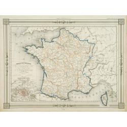
France par Provinces..
Fine map of France with inset plan of Paris at the year 1789, in lower right inset map of Corsica. Prepared by J.G.Barbié du Bocage. Published by Basset, rue de Seine 33...
Date: Paris 1846
Selling price: ????
Please login to see price!
Sold
Isles Britanniques..
Decorative map of England, prepared by J.G.Barbié du Bocage.Engraved by Ch.Smith, published by Basset who was established in Paris, rue de Seine 33. From atlas Illustré...
Date: Paris 1846
Selling price: ????
Please login to see price!
Sold
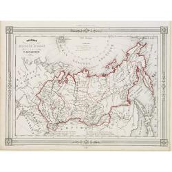
Sibérie ou Russie d'Asie..
Decorative map of Siberia and the further Asian part of Russia, prepared by J.G.Barbié du Bocage.Engraved by Ch.Smith, published by Basset who was established in Paris, ...
Date: Paris 1846
Selling price: ????
Please login to see price!
Sold
La Gréce et ses colonies.
Decorative map of Greece after A.H.Dufour, prepared by J.G.Barbié du Bocage.Engraved by Ch.Smith, published by Basset who was established in Paris, rue de Seine 33. From...
Date: Paris 1846
Selling price: ????
Please login to see price!
Sold
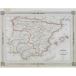
Espagne at Portugal par A.Vuillemin Géographe.
Decorative map of Spain and Portugal, prepared by J.G.Barbié du Bocage.Engraved by Ch.Smith, published by Basset who was established in Paris, rue de Seine 33. From atla...
Date: Paris, 1846
Selling price: ????
Please login to see price!
Sold in 2009

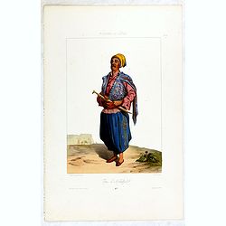
Djar Mougal de la Milice Lesghine Djar. 29
A very decorative print of a Moghul (also spelled Mughal) from the Lesghine militia after Prince Grigory Grigorievich Gagarin and lithographed by J.Keller. Printed by Lem...
Date: Paris, A.Hauser, ca. 1846
Selling price: ????
Please login to see price!
Sold in 2012

Milice Georgienne à Zakataly.
A very decorative print of Georgian militia in Zakataly in the Azerbaijan region after Prince Grigory Grigorievich Gagarin and lithographed by J.Keller. Printed by Lemerc...
Date: Paris, A.Hauser, ca. 1846
Selling price: ????
Please login to see price!
Sold in 2012

Asflan, Kadi de Tsoudakhar. 38
A very decorative print of a Turkish judge of Tsoudakhar in the Daghestan central region after Prince Grigory Grigorievich Gagarin and lithographed by J.Keller. Printed b...
Date: Paris, A.Hauser, ca. 1846
Selling price: ????
Please login to see price!
Sold in 2015

Femme de Kazanistih. Domaine du Chamkhal de Tarky. 39
A very decorative print of a woman from Kazanistih, a Domain of Tarky in Dagestan after Prince Grigory Grigorievich Gagarin and lithographed by J.Keller. Printed by Lemer...
Date: Paris, A.Hauser, ca. 1846
Selling price: ????
Please login to see price!
Sold

TOUCHINE. Costumes du Caucase.
A very decorative print of a Tuchin peasant from Dagestan by Prince Gagarine. Good detail of the costume.The Kumyks live in the plains and the foothills of Dagestan. They...
Date: Paris, A.Hauser, ca. 1846
Selling price: ????
Please login to see price!
Sold

GIORGIENNE DE TIFLIS. Costume de la rue. 43
A very decorative print of Georgian woman from Tiflis by Prince Gagarine. Good detail of the costume.Tiflis Governorate was one of the guberniyas of the Russian Empire wi...
Date: Paris, A.Hauser, ca. 1846
Selling price: ????
Please login to see price!
Sold in 2012

Fille Cosaque de Fcherrlennaia. 44.
A very decorative lithographed print of a Cossack girl after Prince Grigory Grigorievich Gagarin and lithographed by J.Keller. Printed by Lemercier in Paris. The lithogra...
Date: Paris, A.Hauser, ca. 1846
Selling price: ????
Please login to see price!
Sold

Hadji Kodhoua Mehnet, Doyen de Kheïsserukh. Daghestav Meridional. 54
A very decorative print of Hadji Kodhoua Mehnet after Prince Grigory Grigorievich Gagarin and lithographed by J.Keller. Printed by Lemercier in Paris. The lithographed ar...
Date: Paris, A.Hauser, ca. 1846
Selling price: ????
Please login to see price!
Sold

Femme de Temir Khan Choura Dagestan du Nord. 55.
A very decorative print of a woamn from northern Dagestan after Prince Grigory Grigorievich Gagarin and lithographed by J.Keller. Printed by Lemercier in Paris. The litho...
Date: Paris, A.Hauser, ca. 1846
Selling price: ????
Please login to see price!
Sold

Escadron Leghin de la Garde Imperiale à St. Petersbourg (petite tenue) N°56.
A very decorative print of a Leghin squadron Officer of the Imperial Guard after Prince Grigory Grigorievich Gagarin and lithographed by J.Keller. Printed by Lemercier in...
Date: Paris, A.Hauser, ca. 1846
Selling price: ????
Please login to see price!
Sold in 2012

Cosaque de Mosdok en habit de guerre. Ligne du Ferek. N°57.
A very decorative print of a Cossack in military dress after Prince Grigory Grigorievich Gagarin and lithographed by J.Keller. Printed by Lemercier in Paris. The lithogra...
Date: Paris, A.Hauser, ca. 1846
Selling price: ????
Please login to see price!
Sold in 2012

Officier de l'escadron Tcherkesse. De la garde Impériale à St. Petersbourg (en petite tenue). N°58.
A very decorative print of a Circassian squadron Officer of the Imperial Guard in St. Petersberg by Prince Gagarine. Good detail of the costume.Samur region is a region o...
Date: Paris, A.Hauser, ca. 1846
Selling price: ????
Please login to see price!
Sold

Escadron Musulman De la Garde Imperiale à St. Petersbourg ( grande tenue). N°59.
A very decorative print of a Muslim squadron of the Imperial Guard in St. Petersberg by Prince Gagarine. Good detail of the costume.Samur region is a region on the banks ...
Date: Paris, A.Hauser, ca. 1846
Selling price: ????
Please login to see price!
Sold

Escadron Lesghin de la Garde Imperiale à St. Petersbourg ( grande tenue) 60.
A very decorative print of a Lesghin squadron of the Imperial Guard in St. Petersberg after Prince Grigory Grigorievich Gagarin and lithographed by J.Keller. Printed by L...
Date: Paris, A.Hauser, ca. 1846
Selling price: ????
Please login to see price!
Sold

FEMMES TCHERKESSES à GHELENDJIK. (Côte de la Mer Noire).
A very decorative print of Tcherkassy women in Gelendjik after Prince Grigory Grigorievich Gagarin and lithographed by J.Keller. Printed by Lemercier in Paris. The lithog...
Date: Paris, Lemercier, ca. 1846
Selling price: ????
Please login to see price!
Sold

HABITANT de THIRKEY Salataou.
A very decorative print of a Caucasian inhabitant of the town of Salataou after Prince Grigory Grigorievich Gagarin and lithographed by J.Keller. Printed by Lemercier in ...
Date: Paris, A.Hauser, ca. 1846
Selling price: ????
Please login to see price!
Sold

Femme du Chamkhal de Takou.
A very decorative print of a woman from Chamkhal, a village in Dagestan by Prince Gagarine. Good detail of the costume. Signed in Russian with monogram.The Republic of Da...
Date: Paris, A.Hauser, ca. 1846
Selling price: ????
Please login to see price!
Sold in 2016

LE CHAMKHAL de TARKY.
A very decorative print of a Chamkhal from Tarky in Dagestan after Prince Grigory Grigorievich Gagarin and lithographed by J.Keller. Printed by Lemercier in Paris. The li...
Date: Paris, A. Hauser, ca. 1846
Selling price: ????
Please login to see price!
Sold in 2015

FEMMES d'AKHTY. Daghestan Méridional. N°50.
A very decorative print of women from Akhty, in the Russian Federation, Republic of Dagestan after Prince Grigory Grigorievich Gagarin and lithographed by J.Keller. Print...
Date: Paris, A.Hauser, ca. 1846
Selling price: ????
Please login to see price!
Sold in 2015

Indien adorateur du feu à Bacou. N°53.
A very decorative print of Indian immigrant from Baku, Azerbaijan after Prince Grigory Grigorievich Gagarin and lithographed by J.Keller. Printed by Lemercier in Paris. T...
Date: Paris, A. Hauser, ca. 1846
Selling price: ????
Please login to see price!
Sold
Turc d'Akhaltzich.
A very decorative print of a Caucasian Turk after Prince Grigory Grigorievich Gagarin and lithographed by J.Keller. Printed by Lemercier in Paris. The lithographed are be...
Date: Paris, A. Hauser, ca. 1846
Selling price: ????
Please login to see price!
Sold in 2016
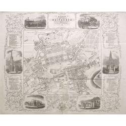
Plan of the City of Edinburgh with all the recent and intended improvements, lines of railways &c.
A rare plan of Edinburgh, surrounded by six views of important buildings and listings of hotels, inns, and many most worthy objects! The detailed plan shows the city with...
Date: Edinburgh, 1846
Selling price: ????
Please login to see price!
Sold in 2015
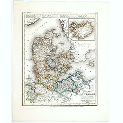
Neueste Karte von Danemark mit Holstein und Lauenburg. . .
A detailed regional map of Denmark, with inset map of the Danish dependency of Iceland. Administrative boundaries hand col. Relief shown by hachures. From Meyer's Hand At...
Date: Hildburghausen, 1846
Selling price: ????
Please login to see price!
Sold in 2021
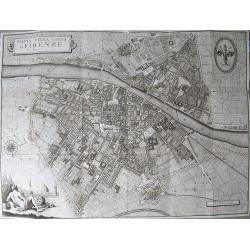
Pianta della Citta di Firenze.
Large decorative folding plan of Florence, copper engraved on thick paper. Folds between original "tree calf" paper covers, with manuscript title label to upper...
Date: Florance, [ND] 1847
Selling price: ????
Please login to see price!
Sold in 2012
Russie d'Europe.
This striking engraved map of Russia comes from Vuillemin's "Universel de Geographie Ancienne et Moderne". The provinces or Oblests are outlined in red. The eng...
Date: Paris, 1847
Selling price: ????
Please login to see price!
Sold in 2013
![[Untitled map of North West Russia with the White Sea].](/uploads/cache/34087-250x250.jpg)
[Untitled map of North West Russia with the White Sea].
Very detailed and rare map of North West Russia with the White Sea. The map has elaborate floral borders. Prepared by Joseph Scheda in Vienna.
Date: Vienna, 1845-1847
Selling price: ????
Please login to see price!
Sold in 2013
![[Untitled map of central part Russia].](/uploads/cache/34088-250x250.jpg)
[Untitled map of central part Russia].
Very detailed and rare map of central part of Russia. The map has elaborate floral borders. Prepared by Joseph Scheda in Vienna.
Date: Vienna, 1845-1847
Selling price: ????
Please login to see price!
Sold in 2013
![[Untitled map of the Ukraine].](/uploads/cache/34089-250x250.jpg)
[Untitled map of the Ukraine].
Very detailed and rare map of the Ukraine. Odessa in bottom and northern part of Lake Azow included. The map has elaborate floral borders. Prepared by Joseph Scheda in Vi...
Date: Vienna, 1845-1847
Selling price: ????
Please login to see price!
Sold in 2013
London And Its Environs. Containing the Boundaries of the Metropolitan Boroughs, the different Railroads & Stations, The New Cemetaries, Roads, Docks, Canals, and all modern improvements ...
The plan covers the extents from Tottenham down to Bromley and Barking across to Hanwell.The plan was dissected into 18 sections and backed onto linen. Folds between dark...
Date: London. 1847
Selling price: ????
Please login to see price!
Sold in 2014
Der Preussische Staat
A fine detailed map of Prussia by Dr. F.W. Streit. Published in Leipzig in 1847. It was produced on two sheets that have been conjoined.
Date: Leipzig, 1847
Selling price: ????
Please login to see price!
Sold in 2016
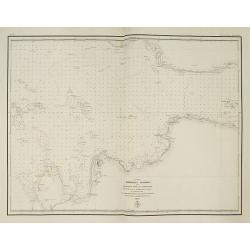
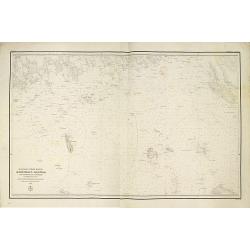
(Title in Russian : the Baltic Sea west of Saint Peterburg with the entrance of Neva Bay with the islands of Moshchny, Ostrov Malyy and the western tip of Kotlin Island.)
This rare chart of the Baltic Sea west of Saint Peterburg with the entrance of Neva Bay with the islands of Moshchny, Ostrov Malyy, and the western tip of Kotlin Island.B...
Date: Saint Petersburg, 1848
Selling price: ????
Please login to see price!
Sold in 2011
Mepkatopckar... (Title in Russian : Baltic Sea east of Helsinki with Kotka and the Islands of Gogland and Moshchny.)
This rare chart of the Baltic Sea east of Helsinki with Kotka and the Islands of Gogland and Moshchny until the Russian coast. Based on the work of Gavril Andreyevich Sar...
Date: Saint Petersburg, 1848
Selling price: ????
Please login to see price!
Sold in 2011