Browse Listings in Europe
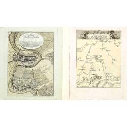
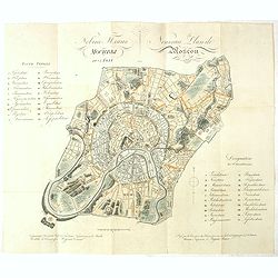
Bern gegen das Ende des dreyzehnten j./ Kriegs-Schauplatz..
Lot of 2 prints showing Bern in ancient times.
Date: Austria 1813/1821
Selling price: ????
Please login to see price!
Sold in 2008
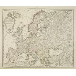
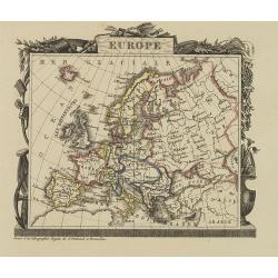
Carte de l'Europe Dressée par G. Delisle et Ph. Buache.. Revue.. Par J. A. Dezauche.
The finely engraved map shows Europe divided up into its countries and the adjacenting regions Russia, the Middle East and North Africa. In the upper left corner we find ...
Date: Paris, 1821
Selling price: ????
Please login to see price!
Sold in 2011
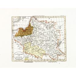
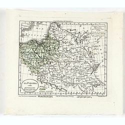
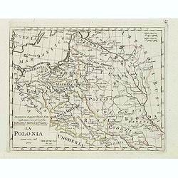
La Polonia colle divisioni del 1772, 1793 e 1795.
A scarce map of Poland and Lithuania. Appears in: Luigi Rossi's "Nuovo atlante di geografia universale". Engraved by Giuseppe Caniani.With color key. In the upp...
Date: Milan, Presso Batelli e Fanfani, 1820 or 1821
Selling price: ????
Please login to see price!
Sold in 2015
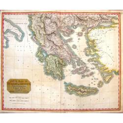
South Part of Turkey in Europe.
A map of Greece, showing Crete, Albania and Turkey. It was drawn & engraved for Thomson's "NEW GENERAL ATLAS" in Edinburgh in 1821.
Date: Edinburgh, 1821
Selling price: ????
Please login to see price!
Sold in 2016
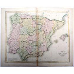
Spain and Portugal drawn & engraved for Dr. Playfair's Atlas.
Fine map of Spain and Portugal from Dr. Playfair's Atlas, from 1821. Published by Macredie, Skelly & Co. in Edinburgh. Engraved by B. Smith.
Date: Edinburgh, 1821
Selling price: ????
Please login to see price!
Sold in 2018
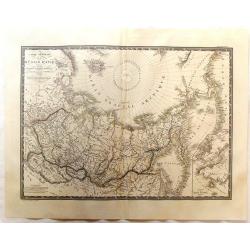
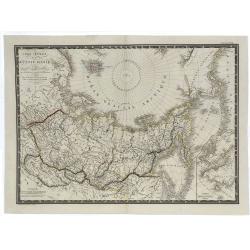
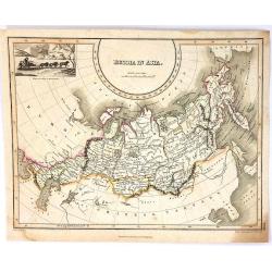
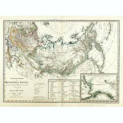
Carte Generale de la Russie d'Asie et des Regions Polaires Borleales.
Fine detailed map of Russia featuring the northern polar regions. The map comes from 'ATLAS UNIVERSEL". Original hand-colored in outline.
Date: Paris, 1821
Selling price: ????
Please login to see price!
Sold in 2017
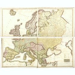
Europe after the Congress of Vienna.
When assembled, this strikingly large 4 sheet map of Europe, measures some 1020 x 1250 mm. The map graphically depicts the political divisions after the Peace of Paris an...
Date: Edinburgh, 1821
Selling price: ????
Please login to see price!
Sold in 2018
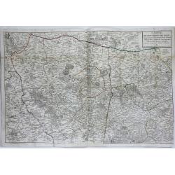
Carte des Environs de Paris.
A large, very detailed map of Paris and her surrounding area by Pichon (Ingeniur Geographe) and corrected by Amedee Martin. It was published by Chez Esnault in Paris in 1...
Date: Paris, 1821
Selling price: ????
Please login to see price!
Sold in 2019
Carte Générale de la Russie d'Asie et des Regions Polaires Boreales.
A fine large-format 1821 Brué map of Russia and the Arctic Ocean featuring the North Pole at the upper centre of the map. Though not a true polar projection, it suggest...
Date: Paris, 1821
Selling price: ????
Please login to see price!
Sold in 2019
La Polonia colle divisioni del 1772, 1793 e 1795.
Uncommon map of Poland and Lithuania. Appears in: Luigi Rossi's "Nuovo atlante di geografia universale". Engraved by Giuseppe Caniani.With color key. In upper r...
Date: Milan, Presso Batelli e Fanfani, 1820 or 1821
Selling price: ????
Please login to see price!
Sold in 2020
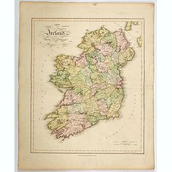
Ancient and Modern Ireland.
A lovely large scale map of the island of Ireland, produced in James Playfair's atlas. The various counties are highlighted in differing colors, with major roads marked, ...
Date: Edinburgh, 1821
Selling price: ????
Please login to see price!
Sold in 2022
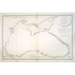
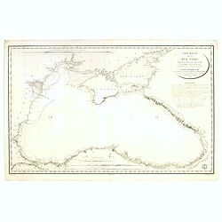
Carte réduite de la Mer Noire... Par M.Gauttier Captaine de Vaisseau secondé par M. Benoist...
Large scale chartof the Black Sea prepared by M. Gautier. Engraved by E.Collin. Stamp of the ‘ Depot General de la Marine’ at lower right corner.The chart shows sound...
Date: Paris, 1822
Selling price: ????
Please login to see price!
Sold in 2013
Carte réduite de la Mer Noire... Par M.Gauttier Captaine de Vaisseau secondé par M. Benoist...
Large scale chartof the Black Sea prepared by M. Gautier. Engraved by E.Collin. Stamp of the ‘ Depot General de la Marine’ at lower right corner.The chart shows sound...
Date: Paris, 1822
Selling price: ????
Please login to see price!
Sold in 2017
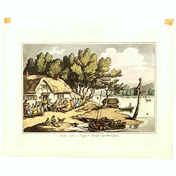
View near Newport Isle of Wight
View near Newport on the Isle of Wight, from an extremely rare series of eighteen aquatint plates, "Rowlandson's Sketches From Nature, depicting views of the West of...
Date: London, 1822
Selling price: ????
Please login to see price!
Sold in 2016
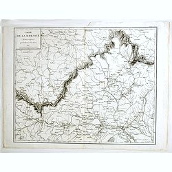
Carte de la Moravie déssinée et gravée par Ambroise Tardieu.
Very detailed map including Vienna and the Czech Republic with Prague Olmutz.
Date: Paris, 1822
Selling price: ????
Please login to see price!
Sold in 2023
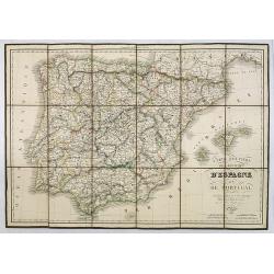
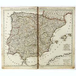
Carte d' Espagne et de Portugal en neuf feuilles. . .
Folding map of Spain and Portugal for the usage of travelers. Published by Edme Mentelle (1730-1815), geographer and historian at the Institut des Sciences, and Jean Bapt...
Date: Paris, 1822
Selling price: ????
Please login to see price!
Sold in 2023
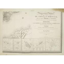
Mapa Civil ii Militar de Espana y Portugal con la nueva Division en distritos enriquecido de los planes particulares de 34 ciudades y puertos principales dedicado A las heroicas naciones espanola y portuguesa. . .
Lower right sheet of a rare six sheet map of Spain and Portugal in its 34 newly divided districts, printed in Paris with Noël et Dauty. Beside the title there are 6 inse...
Date: Paris, 1823
Selling price: ????
Please login to see price!
Sold in 2008
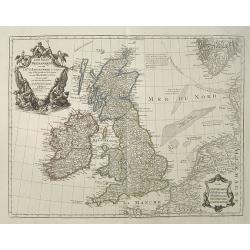
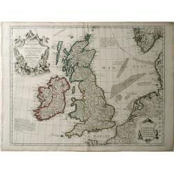
Les Isles Britanniques ou sont le Rme. D'Angleterre . . . Par G. De L'Isle. . . A Paris Chez Dezauche. . .
Uncommon map of the British Isles. The bottom right shows the coasts of the Netherlands, Belgium, and northern France and at the upper right is the southern tip of Norway...
Date: Paris, c.1823
Selling price: ????
Please login to see price!
Sold in 2009
Carte Routière des Royaumes d'Espagne et de Portugal.
Road map of Spain and Portugal. Editor and engraver by L. H. Berthe at the Rue St. Jacques N°66 .
Date: Paris, 1823
Selling price: ????
Please login to see price!
Sold in 2010
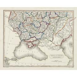
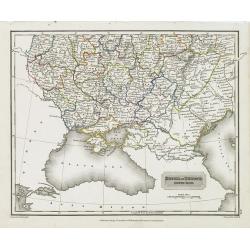
Russia in Europe south past.
Map showing the south of Russia around the Black Sea. Fine steel engraving by Sidney Hall after a drawing by A . Arrowsmith. Published by Archibald Constable
Date: Edinburg, c. 1823
Selling price: ????
Please login to see price!
Sold in 2010
Les Isles Britanniques ou Sont le Rme d\"Angleterre Tire de Speci Celuy d\'Ecosse tire de the Pont &C et Celuy d\'Irlande tire de Petti le tout Rectife par Diverfes Observations.
Map of the British Isles by Guillaume De L'Isle. This wonderfully detailed map includes Great Britain, Scotland, Wales and Ireland, as well as the coast of France. All ma...
Date: Paris, 1823
Selling price: ????
Please login to see price!
Sold in 2010
Russia in Europe south past.
Map sowing the area north of the Crimea region, north of the Black Sea and the Caspian Sea, including the Caucasus.
Date: London, Edinburgh, 1823
Selling price: ????
Please login to see price!
Sold in 2010
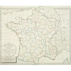
Cartes de France divisée en ses divers départemens,. . .
Map of France showing the different departments, all borders colored in outline.
Date: Paris, 1823
Selling price: ????
Please login to see price!
Sold
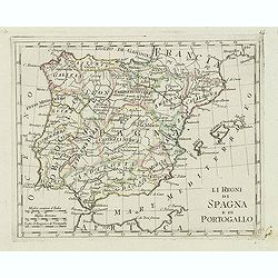
Il regni di spagna e di portogallo.
Charming map of Spain and Portugal from the rare atlas Atlante Tascabile o sia Serie di Num. XXI Cartine Geografiche nelle quali si rappresenta in ristretto lo Stato Attu...
Date: Rome, 1823
Selling price: ????
Please login to see price!
Sold in 2023
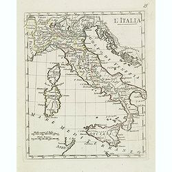
L'italia.
Charming map of Italy, with Corsica and Sardinia from the rare atlas Atlante Tascabile o sia Serie di Num. XXI Cartine Geografiche nelle quali si rappresenta in ristretto...
Date: Rome, 1823
Selling price: ????
Please login to see price!
Sold in 2023
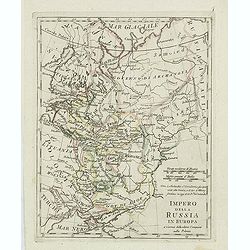
Impero della Russia in Europa. . .
Charming map of European part of Russia from the rare atlas Atlante Tascabile o sia Serie di Num. XXI Cartine Geografiche nelle quali si rappresenta in ristretto lo Stato...
Date: Rome, 1823
Selling price: ????
Please login to see price!
Sold in 2011
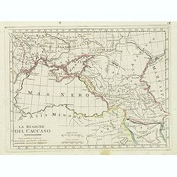
La regione del Caucaso. . .
Charming map of the region around the Black Sea from the rare atlas Atlante Tascabile o sia Serie di Num. XXI Cartine Geografiche nelle quali si rappresenta in ristretto ...
Date: Rome, 1823
Selling price: ????
Please login to see price!
Sold in 2011
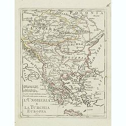
L'ungheria e la turchia Europea. . .
Charming map of Hungary, Macedonia, Bulgaria and Greece from the rare atlas Atlante Tascabile o sia Serie di Num. XXI Cartine Geografiche nelle quali si rappresenta in ri...
Date: Rome, 1823
Selling price: ????
Please login to see price!
Sold in 2011
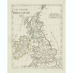
Le isole Britanniche. . .
Charming map of England, Ireland, Scotland from the rare atlas Atlante Tascabile o sia Serie di Num. XXI Cartine Geografiche nelle quali si rappresenta in ristretto lo St...
Date: Rome, 1823
Selling price: ????
Please login to see price!
Sold in 2011
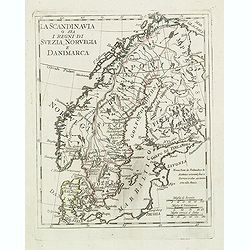
La scandinavia o sia i regni di suezia, norvegia e danimarca.
Charming and uncommon map of Scandinavia, including Norway, Sweden, Denmark, Finland and part of Russia, from the rare atlas Atlante Tascabile o sia Serie di Num. XXI Car...
Date: Rome, 1823
Selling price: ????
Please login to see price!
Sold in 2011
La Polonia comme era nel 1770.
Charming map of Poland during the year 1770 from the rare atlas Atlante Tascabile o sia Serie di Num. XXI Cartine Geografiche nelle quali si rappresenta in ristretto lo S...
Date: Rome, 1823
Selling price: ????
Please login to see price!
Sold in 2012
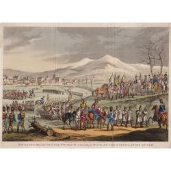
Napoleon Receiving The Sword of General Mack, on the Capitulation of Ulm.
An interesting historical engraving. Engraved by George Cruikshank from the original design of C. Vernet, executed at Paris by I. Duplessi Bertaux.Published on December 2...
Date: London, 1823
Selling price: ????
Please login to see price!
Sold in 2019

Napoleon Forcing the Passage of the Bridge of Arcola.
"Napoleon Forcing the Passage of the Bridge of Arcola."Engraved by George Cruikshank from the original design of C. Vernet, executed at Paris by I. Duplessi Ber...
Date: London, 1823
Selling price: ????
Please login to see price!
Sold in 2020
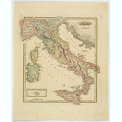
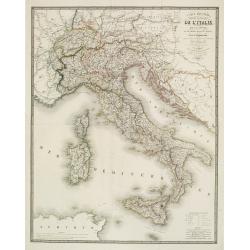
Italy.
Fielding Lucas's 1823 elegantly engraved map of Italy. Fielding Lucas' fine work distinguished him as one of the best publishers of his era. His maps are printed on a hig...
Date: Baltimore, 1823
Selling price: ????
Please login to see price!
Sold in 2019
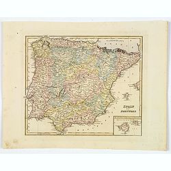
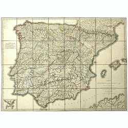
Spain and Portugal.
Fielding Lucas's 1823 elegantly engraved map of Spain & Portugal, with an inset of the islands of Majorca and Minorca. Fielding Lucas' fine work distinguished him as ...
Date: Baltimore, 1823
Selling price: ????
Please login to see price!
Sold in 2019
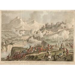
Napoleon & Massena Defeating The Austrian Army, At The Terrible Battle of Roveredo.
Napoleon & Massena defeating The Austrian Army, at The Terrible Battle of Roveredo, engraved by George Cruikshank from the original design of C. Vernet, executed at P...
Date: London, 1823
Selling price: ????
Please login to see price!
Sold in 2020
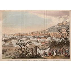
The Attack and Capture of Naples By The French After A Most Obstinate Resistance.
The Attack and Capture of Naples by The French After A Most Obstinate Resistance, engraved by George Cruikshank from the original design of C. Vernet, executed at Paris b...
Date: London, 1823
Selling price: ????
Please login to see price!
Sold in 2020
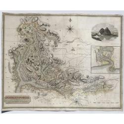
Dumbartonshire Sur'd by Wood for the Atlas of Scotland.
FA fne map of Dumbatonshire, Scotland by John Thomson in 1823. From his Atlas of Scotland published in Edinburgh. It features an inset of the Firth of Clyde and an engrav...
Date: Edinburgh, 1823
Selling price: ????
Please login to see price!
Sold in 2020
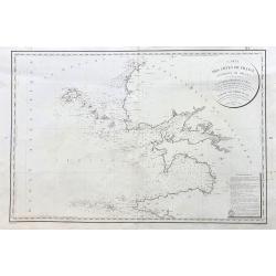
Carte des Cotes de France (environs de Brest) levee en 1816 1817 et 1818
A large sea-chart of the western parts of Finistère in the Bretagne, showing Ouessant, Brest, Plouguerneau, Crozon, Ile de Sein, and Audierne. With fantastic detail ...
Date: Paris, 1823
Selling price: ????
Please login to see price!
Sold in 2023
Carte Routière, Physique et Politique de l? Italie, de la Suisse, et de Parties des Etats Voisins..
Detailed map of Italy, Switzerland, Slovenia, Croatia, Dalmatia and parts of the neighbouring countries.With title above right, and a key and 5 scales at lower right.Engr...
Date: Paris 1824
Selling price: ????
Please login to see price!
Sold
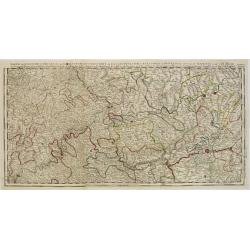
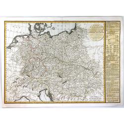
Partie des Estats Des Cercles des quatre Electeurs et Du Haut Rhin ou sont L'Archevesché et Electorat de Treves..
Detailed map of Rhineland-Palatinate and part of the contiguous regions.Towns highlighted in red. Showing Trier, Bonn, Koblenz, Frankfurt and Mainz.Prepared by Henry Seng...
Date: Paris 1824
Selling price: ????
Please login to see price!
Sold
Europe. . .
Attractive map of Europe with decorative borders depicting typical artifacts and produce of the continent. Published in Les jeunes voyageurs en Europe.. . Engraved by J.G...
Date: Brussels, 1824
Selling price: ????
Please login to see price!
Sold in 2013
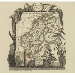
Suede et Norvege.
Attractive map of Norway and Sweden with decorative borders depicting typical artifacts and produce of the continent. Published in Les jeunes voyageurs en Europe.. . Engr...
Date: Brussels 1824
Selling price: ????
Please login to see price!
Sold in 2010
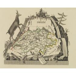
Suisse
Attractive map of Switzerland with decorative borders depicting typical artifacts and produce of the continent. Published in Les jeunes voyageurs en Europe.. . Engraved b...
Date: Brussels, 1824
Selling price: ????
Please login to see price!
Sold in 2020
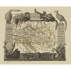
Autriche
Attractive map of Austria with decorative borders depicting typical artifacts and produce of the continent. Published in Les jeunes voyageurs en Europe.. . Engraved by va...
Date: Brussels, 1824
Selling price: ????
Please login to see price!
Sold in 2013
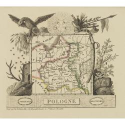
Pologne.
Attractive map of Poland with decorative borders depicting typical artifacts and produce of the continent. Published in Les jeunes voyageurs en Europe.. . Engraved by Van...
Date: Brussels 1824
Selling price: ????
Please login to see price!
Sold in 2010

Prusse
Attractive map of Prussia with decorative borders depicting typical artifacts and produce of the continent. Published in Les jeunes voyageurs en Europe.. . Engraved by J....
Date: Brussels, 1824
Selling price: ????
Please login to see price!
Sold in 2010
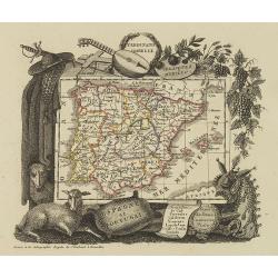
Espagne et Portugal
Attractive map of Spain and Portugal with decorative borders depicting typical artifacts and produce of the continent. Published in Les jeunes voyageurs en Europe.. . Eng...
Date: Brussels, 1824
Selling price: ????
Please login to see price!
Sold in 2015
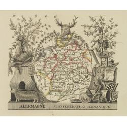
Allemagne (confédération Germanique)
Attractive map of Germany with decorative borders depicting typical artifacts and produce of the continent. Published in Les jeunes voyageurs en Europe.. . Engraved by th...
Date: Brussels, 1824
Selling price: ????
Please login to see price!
Sold in 2011
Carte pour servir à l'histoire de Napoléon et de la Grande Armée. . .
Uncommon map of the Baltic sea to Moscow. Map showing the cities of Stockholm, Petersburg, Varsovie, Moscow. Prepared by A.M. Perrot. Engraved by Berthe.The map was made ...
Date: Paris, 1824
Selling price: ????
Please login to see price!
Sold in 2011
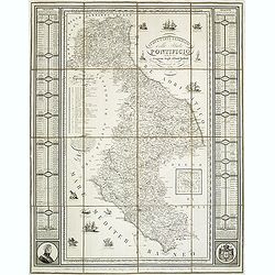
NUOVA CARTA GEOGRAFICA dello stato PONTIFICIO delineata a norma degli ultimi trattati e del Riparto Serritoriale 26 Novembre 1817 ROMA. . .
Rare map of the Papal States, published in 1824 and engraved by Francesco Valenti and published in Rome by L. Riccardi in 1824. Dedicated to the Duke of "Blacas d’...
Date: Rome, L. Riccardi, 1824
Selling price: ????
Please login to see price!
Sold in 2011
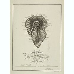
Carte physique de L'Ile de Palma par Leopold de Buch.
Plate III from Atlas des Iles Canaries. Engraved by P. Tardieu in 1824. In lower left corner "Dessiné sur les lieux par Leopold de Buch en 1814".Christian Leop...
Date: Paris, 1824
Selling price: ????
Please login to see price!
Sold in 2013
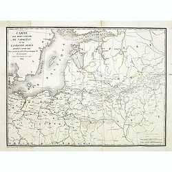
![[Untitled map of a part of Poland and Prussia].](/uploads/cache/35692-250x250.jpg)
[Untitled map of a part of Poland and Prussia].
Large folding map, being upper right part of a multi-sheet map, showing the northern part of Poland with good detail around Gdansk. Published by Jean Claude Dezauche (17...
Date: Paris, ca. 1816-1824
Selling price: ????
Please login to see price!
Sold in 2015
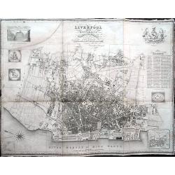
Liverpool and its Environs.
An uncommon plan of Liverpool with excellent detail of the city, docks and surrounding countryside. An extensive key identifies important sites and a small vignette shows...
Date: Liverpool, ca 1824
Selling price: ????
Please login to see price!
Sold in 2018
Carte Generale du Royaume de Prusse. . .
A nice French map, typical of the period, of the Kingdom of Prussia, by Vivien, from the "Atlas Universel Pour servir a l'Etude De la Geographie et de l'Histoire Anc...
Date: Paris, 1824
Selling price: ????
Please login to see price!
Sold in 2021
Nouveau Plan de Moscou 1825 / Dressee par la Commission des batimens pour servir au Guide du Voyageur par G.L. DeLaveau. Moscou, Imprimerie d' Auguste Semen.
This lovely rare authentic antique traveler’s folding guide of Moscow by G.L. De Laveau is dated 1824, a mere twelve years following Napoleon’s invasion, the destruct...
Date: Moscow, A. Semen, 1824
Selling price: ????
Please login to see price!
Sold in 2021

(TWO PRINTS of Eise Eisinga Planetarium in Franeker ) Schynbare beweging der zon en vaste sterren)
Two very rare and large engravings show the interior with an astrological chart on the ceiling in the Eisinga Planetarium, the oldest working Planetarium in the world. Ei...
Date: Arnhem, 1824
Selling price: ????
Please login to see price!
Sold in 2023
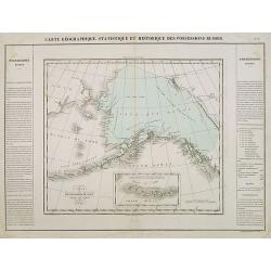
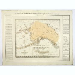
Carte des Possessions Russes.
A very significant, desirable map of Alaska still possessed by Russia. From J.A. Buchon, "Atlas Gégraphique Statistique, historique et chronologique des deux Ameriq...
Date: Paris, 1825
Selling price: ????
Please login to see price!
Sold in 2012

Scenes in London A new game.
A curious game with 18 London scenes. The original slipcase has a hand-colored pictorial label showing the London Thames and in the background St. paul Cathedral, publish...
Date: London, E.Wallis, ca. 1825
Selling price: ????
Please login to see price!
Sold in 2017
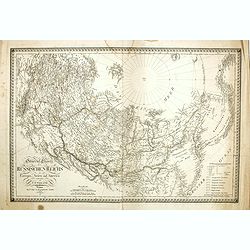
General Charte des Russischen Reichs in Europa, Asien, und America. . .
Uncommon map of Russia, prepared by C.F.Weiland. In the upper right corner the tip of Alaska Major Russian cities are underlined in orange ink lines. To the lower right a...
Date: Weimar, 1825
Selling price: ????
Please login to see price!
Sold in 2014
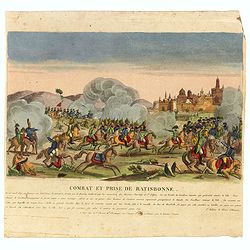
Combat et prise de Ratisbonne.
Print published in "Paris chez la Ve. Chéreau M.de d'estampes, rue St. Jacques N°10, aux deux Colonnes, près la Fontaine St. Séverin". The text below the pr...
Date: Paris, Vve Chéreau, before 1825
Selling price: ????
Please login to see price!
Sold in 2016
Russia in Asia
An attractive map of the eastern part of Russia. Published by Thomson in his "A GENERAL ATLAS...." in Edinburgh in 1825. The map is by James Wyld, the renowned ...
Date: Edinburgh, 1825
Selling price: ????
Please login to see price!
Sold in 2016
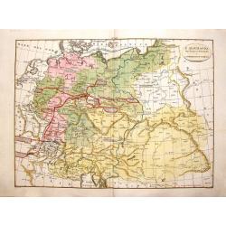
Carte de l'Allemagne Contenant les Etats de la Confédération Germanique, le Royaume de Prusse.
A large, finely detailed map of central Europe, showing the Confederation of the Rhine, which was formed in 1806 by a group of Germans, that decided to throw their nation...
Date: Paris, 1825
Selling price: ????
Please login to see price!
Sold in 2016
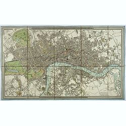
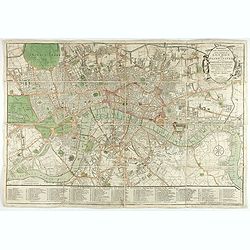
A new Plan of London and Westminster, with the borough of Southwark. 1825.
Beautiful plan of London, Westminster and Southwark, with parks and gardens in green published by James Wyld. To the right of the plan are the famous London docks built i...
Date: London, 1825
Selling price: ????
Please login to see price!
Sold in 2017
Karte der beeden koenidreiche Spanien und Portugal.
Uncommon map of Spain and Portugal published by Johannes Walch.Johann Walch (1757-1824) was cartographer and map publisher active in Augsburg, he was the son-in-law of Jo...
Date: Augsburg, 1825
Selling price: ????
Please login to see price!
Sold in 2019
Carte Geographique, Statistique et Historique des Possessions Russes.
A very significant, desirable map of Alaska still possessed by Russia, From Buchon's Atlas Gégraphique Statistique, historique et chronologique des deux Ameriques et des...
Date: Paris, 1825
Selling price: ????
Please login to see price!
Sold in 2019
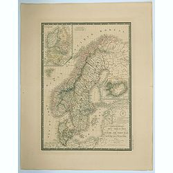
Carte Generale des Royaumes de Suede, de Norvege et de la Danemark.
A fine and detailed large map of the region with insets of Denmark, Faroe Islands, and Iceland. A scroll style title with the embossed royal seal, a keyboard style border...
Date: Paris, 1825
Selling price: ????
Please login to see price!
Sold in 2021

Wormerveer village de la Nord Hollande.
Print showing ice skating in the village Wormerveer situated in the Dutch province Noord-Holland. From “Voyage Pittoresque dans le Royaume des Pays-Bas”, by Mr. De Cl...
Date: Brussels, J. B. A. Jobard, 1825
Selling price: ????
Please login to see price!
Sold in 2023
Bowles's one-sheet pan of the cities of London and Westminster
Bowles detailed map of London was updated regularly through the first decade of the 19th century. In addition to providing large scale detail, Bowles maps are also illust...
Date: London, 1825
Selling price: ????
Please login to see price!
Sold in 2022
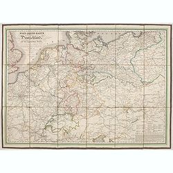
Post-reise-karte von Deutschland und den angränzernden Staaten.
Uncommon post road mapspost route map of Germany, Poland, the Low Countries, Switzerland, Austria and Hungary.
Date: Augsburg, 1826
Selling price: ????
Please login to see price!
Sold in 2021
General Charte des Russischen Reichs. . .
Rare map of Russia, including Poland, Baltic, Ukraine, Siberia, Kurilles and in the lower right corner an inset map of Alaska and Bering Street. Engraved and published by...
Date: Nürnberg, 1826
Selling price: ????
Please login to see price!
Sold in 2014
L'Alemagna dopo il Congresso di Vienna, 1815.
Pleasing hand colored map of Germany and Northern Italy. It was published by Girolamo Tasso in Venice in 1826 and engraved by G.V. Pasquali.
Date: Venice, 1826
Selling price: ????
Please login to see price!
Sold in 2016
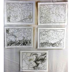
(5 Maps) from “Precis des Evenemens Militares”
A collection of five out a total of 117 specific military events and plans to serve the intelligence of military operations described in the text. These maps are numbered...
Date: Paris, ca 1826
Selling price: ????
Please login to see price!
Sold in 2016
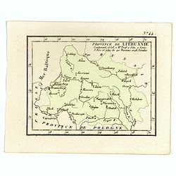
Province de Lithuanie contenant 15 Col. 2 M.on Prof. 2 Sém. 2 Novic. 3 Rés. Et plus de 40 Jésuites.
Rare map of Lithuania from "Atlas Universel indiquant les établissemens des Jésuites: avec la manière dont ils divisent la terre, suivi desévénemens remarquable...
Date: Paris, Ambroise Dupont , 1826
Selling price: ????
Please login to see price!
Sold in 2017
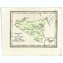
Province de Sicile Contenant 29 Collèges 2.M.ons Prof. 2 Noviciats, et 775 Jés.tes.
Rare map of Sicily from "Atlas Universel indiquant les établissemens des Jésuites: avec la manière dont ils divisent la terre, suivi desévénemens remarquables d...
Date: Paris, Ambroise Dupont , 1826
Selling price: ????
Please login to see price!
Sold in 2017
![Honsdon House & Stanstedbury [2 Litho's].](/uploads/cache/81218-250x250.jpg)
Honsdon House & Stanstedbury [2 Litho's].
Two antique lithographed prints drawn from the original engravings on stone by C.L.Tyler. Published in the second edition of Sir Henry Chauncy's "Historical Antiquit...
Date: Bishop's Stortford, 1826
Selling price: ????
Please login to see price!
Sold in 2020
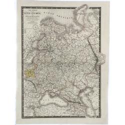
Carte Générale de la Russie d'Europe, du Royaume de Pologne, des environs de Caucase et d'une partie des Pays Adjacents.
A fine large-format 1826 A. H. Brué's map of the European Russia. It shows all of Poland and extends east to the Black Sea to show all of the Crimea, and north to above ...
Date: Paris, 1826
Selling price: ????
Please login to see price!
Sold in 2019
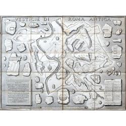
Pianta delle vestigia di Roma. . .
An unusual large-scale map of ancient Rome with names and details. Plans of important buildings are shown looking like broken fragments of stone. An index lists 28 import...
Date: Rome, ca. 1826
Selling price: ????
Please login to see price!
Sold in 2020
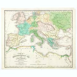
The Mediterranean Sea with the Countries on its Borders.
An interesting and unusual map of the Mediterranean Sea, and her adjoining countries, published in America during the first half of the nineteenth century as part of Hart...
Date: America, ca 1826
Selling price: ????
Please login to see price!
Sold in 2020
L'Empire Russe en Europe et en Asie avec ses acquisitions..
Map showing the extension of the Russian Empire at the beginning of the XIXth century. Several letterpress notations are present on the map.Surrounding letterpress explan...
Date: Paris, 1827
Selling price: ????
Please login to see price!
Sold in 2009