Browse Listings in Europe
![[ Costumes des Scythes royaux ]](/uploads/cache/24476-250x250.jpg)
[ Costumes des Scythes royaux ]
Aquatint depicting "Royal Scythians". Engraved by D.K. Bonatti, after drawings by A. Monticelli. Plate N° 16.From Giulio Ferrario''s work Le Cos...
Date: Milan, 1827
Selling price: ????
Please login to see price!
Sold in 2009
![[Femmes du Taschkent - inhabitants of Turkestan]](/uploads/cache/24479-250x250.jpg)
[Femmes du Taschkent - inhabitants of Turkestan]
Aquatint engraved by D.K. Bonatti, after drawings by C. Bottigella of a family of Turkestan. Plate N° 20.From Giulio Ferrario''s work Le Costume Ancien et Moderne ou His...
Date: Milan, 1827
Selling price: ????
Please login to see price!
Sold in 2009
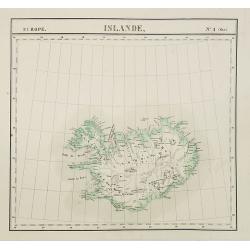
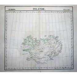
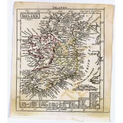
Islande.
PLANO SHEET : Map of Iceland: No. 1.bis covering Iceland, from his famous Atlas Universel.This atlas was one of the most remarkable world atlases ever produced, anticipat...
Date: Brussels, 1825-1827
Selling price: ????
Please login to see price!
Sold in 2016
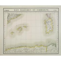
Europe. Isles Baléares et Sardaigne. N.25.
Detailed map including Baleares and Sardinia. Along the lower part the coast line of Algeria.From his famous Atlas Universel . This atlas was one of the most remarkable w...
Date: Brussels, 1825-1827
Selling price: ????
Please login to see price!
Sold in 2013
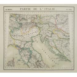
Europe. Partie de la Italie. N°20.
Detailed map including northern part of Italy and Istria and Croatia. In lower left corner part of the island of Corsica.From his famous Atlas Universel . This atlas was ...
Date: Brussels, 1825-1827
Selling price: ????
Please login to see price!
Sold in 2023
![[ Shamanes - Téleuths ].](/uploads/cache/25819-250x250.jpg)
[ Shamanes - Téleuths ].
Aquatint depicting a woman dancing around a camp fire engraved by D.K. Bonatti, after drawings by C. Bottigella of a family of Turkestan. Plate N° 27.From Giulio ...
Date: Milan, 1827
Selling price: ????
Please login to see price!
Sold in 2009
![[ Spitzbergen ]](/uploads/cache/27540-250x250.jpg)
[ Spitzbergen ]
Uncommon aquatint depicting the southern bay of Spitzbergen, engraved by Fumagalli. From Giulio Ferrario's work Le Costume Ancien et Moderne ou Histoire du gouvernement, ...
Date: Milan, 1827
Selling price: ????
Please login to see price!
Sold in 2020
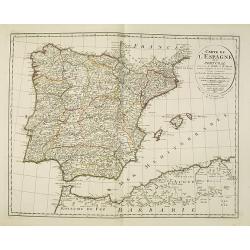
Carte de L'Espagne et du Portugal. . .
Very interesting map of Spain and Portugal including Majorca and Minorca. Buache drew heavenly on the work of Delisle.Philippe Buache de la Neuville was born in Neuville-...
Date: Paris, 1827
Selling price: ????
Please login to see price!
Sold in 2023
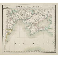
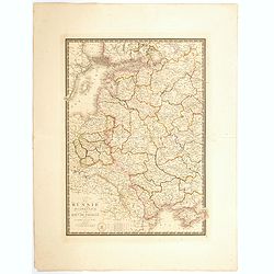
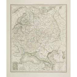
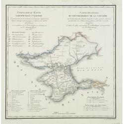
Europe. Partie de la Russie. N°22.
Detailed map of the Crimea region.From his famous Atlas Universel . This atlas was one of the most remarkable world atlases ever produced, anticipating the International ...
Date: Brussels, 1825-1827
Selling price: ????
Please login to see price!
Sold in 2010
![[Costume plate of warriors and a Prince of the Usden Circassiens tribe in the Caucasus ]](/uploads/cache/62340-250x250.jpg)
[Costume plate of warriors and a Prince of the Usden Circassiens tribe in the Caucasus ]
Aquatint costume plate of a Cabarde prince and of a Usden. The person most right presents a Khan Circassian. Plate N° 11. From Giulio Ferrario's work Le Costume ancien e...
Date: Milan, 1827
Selling price: ????
Please login to see price!
Sold
![[Costume plate of various Circassians classes. ]](/uploads/cache/62341-250x250.jpg)
[Costume plate of various Circassians classes. ]
Aquatint costume plate of various Circassians classes designed by Mr. Pelagio Palagi. The most left and right figures are two of the Kuban Circassians and the one second ...
Date: Milan, 1827
Selling price: ????
Please login to see price!
Sold
![[Costume plate of Circassian women from the Caucasus]](/uploads/cache/62342-250x250.jpg)
[Costume plate of Circassian women from the Caucasus]
Aquatint costume plate of Circassian women from the Caucasus, designed by Mr. Pelagio Palagi. Plate N°13.From Giulio Ferrario's work Le Costume ancien et moderne ou hist...
Date: Milan, 1827
Selling price: ????
Please login to see price!
Sold
![[Costume plate of dancing Circassians - Caucasus]](/uploads/cache/62343-250x250.jpg)
[Costume plate of dancing Circassians - Caucasus]
Aquatint costume plate of dancing Circassians in the Caucasus, designed by Mr. Pelagio Palagi. Plate N°14.From Giulio Ferrario's work Le Costume ancien et moderne ou his...
Date: Milan, 1827
Selling price: ????
Please login to see price!
Sold
![[Costumes des Scythes - Tartarie]](/uploads/cache/62345-250x250.jpg)
[Costumes des Scythes - Tartarie]
Aquatint printed by D. Bonatti. After a design of A. Monticelli.Published in "Le Costume Ancien et Moderne ou Histoire du gouvernement, de la milice, de la religion,...
Date: Milan, 1827
Selling price: ????
Please login to see price!
Sold in 2017
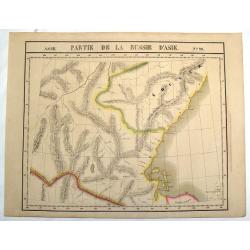
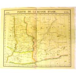
Asie, Partie de la Russie D'Asie, No. 26.
Large, hand-colored, lithographed map of the Khabarovsky Kray Oblest of Russia. Important ,as it probably was, at the time, the most detailed and largest map of this v...
Date: Brusselles, 1827
Selling price: ????
Please login to see price!
Sold in 2013
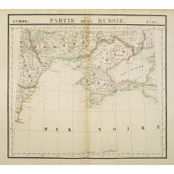
Europe. Partie de la Russie. N°22.
Detailed map of the Crimea region.From his famous Atlas Universel . This atlas was one of the most remarkable world atlases ever produced, anticipating the International ...
Date: Brussels, 1825-1827
Selling price: ????
Please login to see price!
Sold in 2010
Islande N° 1
Highly detailed and important map Iceland. Shows the entire island with many towns, glaciers, rivers, bays,...Vandermaelen accomplished the first atlas with map of the wo...
Date: Brussels, 1827
Selling price: ????
Please login to see price!
Sold in 2011
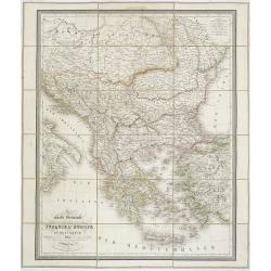
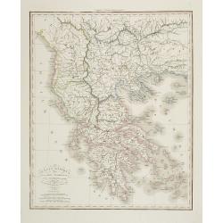
Carte Générale de la Turquie d'Europe et de la Grèce. . .
Map of Greece, including the regions of Romania, Bulgaria, Bosnia, Servia and part of the Black Sea with the western part of Turkey including Constantinople. Published a...
Date: Paris, 1827
Selling price: ????
Please login to see price!
Sold in 2011
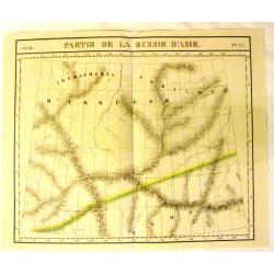
Asie, Partie de la Russie D'Asie No.24.
Large, hand-colored, lithographed map of Irkutsk and the Lake Baikal region of Russia. Important ,as it probably was, at the time, the most detailed and largest map of th...
Date: Brusselles, 1827
Selling price: ????
Please login to see price!
Sold in 2013

Les Islandais.
Showing the traditional hairstyle of the women of Iceland. From Giulio Ferrario's work Le Costume ancien et moderne ou histoire du gouvernement, de la milice, de la relig...
Date: Milan, 1827
Selling price: ????
Please login to see price!
Sold in 2018
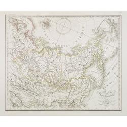
![[67 sheets - The Russian Empire in EUROPE & ASIA ]](/uploads/cache/35290-250x250.jpg)
[67 sheets - The Russian Empire in EUROPE & ASIA ]
A set of 67 maps covering the Russian Empire at time of publication. From his famous Atlas Universel . This atlas was one of the most remarkable world atlases ever produc...
Date: Brussels, 1825-1827
Selling price: ????
Please login to see price!
Sold in 2014
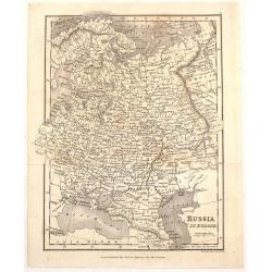
Mawman's Russia in Europe.
Fine little map of "Russia in Europe" published by J. Mawman & the Other Proprietors" in London in 1827. It was engraved by J. Neele.
Date: London, 1827
Selling price: ????
Please login to see price!
Sold in 2015
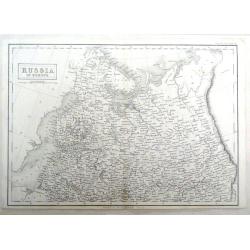
Russia in Europe, Northern Part.
Detailed map of Northern Russia in Europe by Sidney Hall in 1827, published in London. It includes "Russian Lapland".
Date: London, 1827
Selling price: ????
Please login to see price!
Sold in 2016
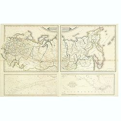
Asie, Partie de la Russie d'Asie, No.21.
Fine, large map of Russia by Philippe Vandermaelen (1795-18690, the well known Belgian geographer. It is from the Universal Atlas published in 1827.Featured is "PART...
Date: Brussels, 1827
Selling price: ????
Please login to see price!
Sold in 2015
Asie, Partie de la Russie d'Asie, No.17.
Fine, large map of Russia by Philippe Vandermaelen (1795-18690, the well known Belgian geographer. It is from the Universal Atlas published in 1827.Featured is "PART...
Date: Brussels, 1827
Selling price: ????
Please login to see price!
Sold in 2015
Asie, Partie de la Russie d'Asie, No.26.
Fine, large map of Russia by Philippe Vandermaelen (1795-18690, the well known Belgian geographer. It is from the Universal Atlas published in 1827.Featured is "PART...
Date: Brussels, 1827
Selling price: ????
Please login to see price!
Sold in 2015
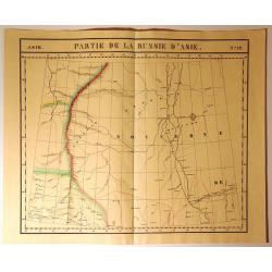
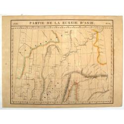
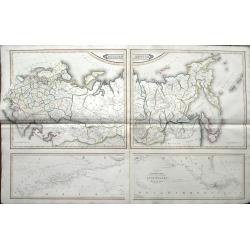
Partie de la Russie d'Asie, No. 12
From Vandemaelen’s “Atlas Universel”. This monumental work was the first atlas of the world with all maps on the same scale (about one inch to 26 miles), and the fi...
Date: Brusselles, 1827
Selling price: ????
Please login to see price!
Sold in 2015
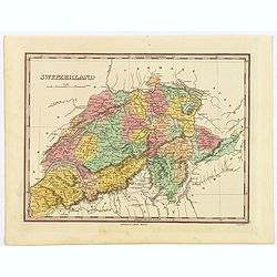
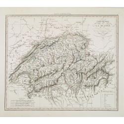
Switzerland.
A beautiful example of Finley's 1827 map of Switzerland. With Finley's classic minimalist style, this map identifies cities, forests, river systems, swamps and mountains....
Date: Philadelphia, 1827
Selling price: ????
Please login to see price!
Sold in 2019
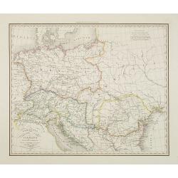
Carte de la Russie occidentale et du Royme. de Pologne par A. Brue, Geographe du Roi . . .
A large folio steel engraved map of Russia and Poland from his the Brue "Universal Atlas of physical geography, politics, ancient & modern." It shows wester...
Date: Paris, 1827
Selling price: ????
Please login to see price!
Sold in 2020
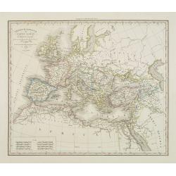
Imperium Romanum ou Empire Romain . . .
Detailed map of the ancient Roman Empire covering southern Europe, North Africa and part of Asia, prepared by A. H. Basset, rue Saint-Jacques, no. 64, Paris and published...
Date: Paris, A.H. Basset, 1828
Selling price: ????
Please login to see price!
Sold in 2009
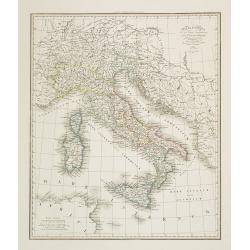
Italia Antiqua . . .
Detailed map of Ancient Italy, including Sardinia and Corsica, published by A. H. Basset, rue Saint-Jacques, no. 64, Paris and published in Atlas classique et Universel d...
Date: Paris, A.H. Basset, 1828
Selling price: ????
Please login to see price!
Sold in 2023
Grecia Antiqua . . .
Detailed map of Ancient Greece, prepared by A. H. Basset, rue Saint-Jacques, no. 64, Paris and published in Atlas classique et Universel de Géographie . . . .The engrave...
Date: Paris, A.H. Basset, 1828
Selling price: ????
Please login to see price!
Sold in 2022
Germania pannonia d'Acia et Sarmatia ad Juventutis Institutionem . . .
Map of Ancient central Europe, prepared by A. H. Basset, rue Saint-Jacques, no. 64, Paris and published in Atlas classique et Universel de Géographie . . . .The engraver...
Date: Paris, A.H. Basset, 1828
Selling price: ????
Please login to see price!
Sold in 2009
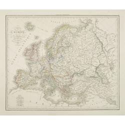
Carte de l'Europe . . .
Detailed map of Europe, prepared by A. H. Basset, rue Saint-Jacques, no. 64, Paris and published in Atlas classique et Universel de Géographie . . . .The engraver of the...
Date: Paris, A.H. Basset, 1828
Selling price: ????
Please login to see price!
Sold in 2009
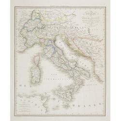
Italie et Royaume d'Illyrie . . .
Detailed map of Italy, prepared by A. H. Basset, rue Saint-Jacques, no. 64, Paris and published in Atlas classique et Universel de Géographie . . . .The engraver of the ...
Date: Paris, A.H. Basset, 1828
Selling price: ????
Please login to see price!
Sold in 2023
Carte routière de la Suisse . . .
Road map of Switzerland, prepared by A. H. Basset, rue Saint-Jacques, no. 64, Paris and published in Atlas classique et Universel de Géographie . . . .The engraver of th...
Date: Paris, A.H. Basset, 1828
Selling price: ????
Please login to see price!
Sold
Scandinavie ou Suède et Norwège et Royaume de Danemark . . .
Detailed map of Sweden, Norway, Finland and Denmark, prepared by A. H. Basset, rue Saint-Jacques, no. 64, Paris and published in Atlas classique et Universel de Géograph...
Date: Paris, A.H. Basset, 1828
Selling price: ????
Please login to see price!
Sold in 2010
Russie d'Europe . . .
Detailed map of the European part of Russia, including the Black Sea region, prepared by A. H. Basset, rue Saint-Jacques, no. 64, Paris and published in Atlas classique e...
Date: Paris, A.H. Basset, 1828
Selling price: ????
Please login to see price!
Sold in 2009
Russie d'Asie. . .
Detailed map of Siberia, China and part of Alaska, prepared by A. H. Basset, rue Saint-Jacques, no. 64, Paris and published in Atlas classique et Universel de Géographie...
Date: Paris, A.H. Basset, 1828
Selling price: ????
Please login to see price!
Sold in 2010
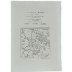
Carte générale du gouvernement de la Tauride. . .
Very rare map of Crimea with title in Russian and French from the atlas by Vasilii Petrovich PIADYSHEV [PIADISCHEFF] (1769-1836 Functionary of the 6th Rank.) : Geografice...
Date: St.Petersburg, Topographic Depot, 1828
Selling price: ????
Please login to see price!
Sold in 2010
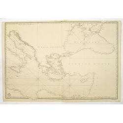
(Chart centered on the Eastern Mediterranean and Black Sea.)
Very detailed chart centered on Greece and Turkey, with the Black Sea and Southern part of Italy. Engraved by Besançon, prepared by Charles-François Beautemps-Beaupré....
Date: Paris, c.1828
Selling price: ????
Please login to see price!
Sold in 2016
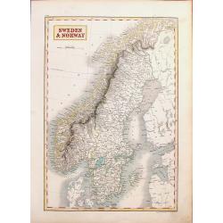
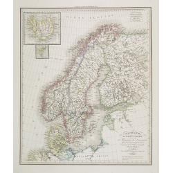
Sweden & Norway.
A striking hand-colored engraving featuring Sweden & Norway. It was engraved by Syd Hall and published in "A NEW GENERAL ATLAS" by Longman, Rees, Brown &...
Date: London, 1828
Selling price: ????
Please login to see price!
Sold in 2018
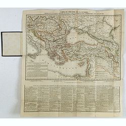
Carte du théatre de la guerre, comprenant la Turquie d'Europe et d'Asie, la Grèce entière et pays limitrophes, avec les routes. . .
Rare map of the Black Sea are, with the Caucasus, Turkey, Greece and Ukraine. Printed from two copper plates. Lower part containing "Suite de la description des prov...
Date: Paris, H. Langlois, fils, 1828
Selling price: ????
Please login to see price!
Sold in 2020
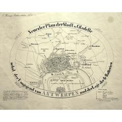
Neuester Plan der Stadt und Citadelle nebst der Umgegend von ANTWERPEN und der Lage der fr. Batterien.
Curious and apparently rare plan of Antwerp and surroundings, published in "Hennig's Bilderschätze". With two keys 1-15 and 1-6 identifying buildings and forti...
Date: Prague, ca. 1828
Selling price: ????
Please login to see price!
Sold in 2015
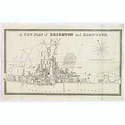
A new plan of Brighton and Kemp-Town.
An attractive and scarce town plan of Brighton and Kemp Town towards the end of the reign of George IV in 1828. You see development all along Kings Road and Marine Parade...
Date: London, 1828
Selling price: ????
Please login to see price!
Sold in 2020
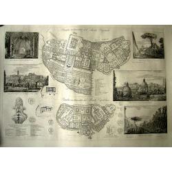
Pianta restaurata del Monte Quirinale.
Famous and rare plan of the Monte Quirinale in Rome. Engraved by Vespignani, designed by Rossini. Large sheet, with 2 detailed plans of the Monte Quirinale and Monte Capi...
Date: Italy, 1827-1829
Selling price: ????
Please login to see price!
Sold in 2011
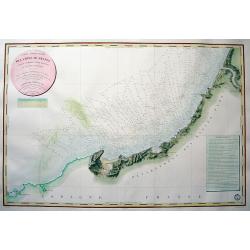
CARTE DES CÔTES DE FRANCE PARTIE COMPRISE ENTRE BAYONNE ET LA CÒTE D'ESPAGNE...
Highly decorative and scarce large-scale engraved seachart of the French and Spanish region at the Bay of Biscay / Coasts of Cantabria. Drawn by Besancon, engraved by Mic...
Date: Paris, 1829
Selling price: ????
Please login to see price!
Sold in 2010
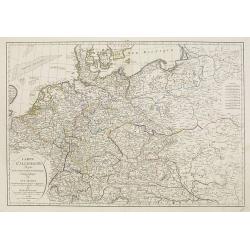
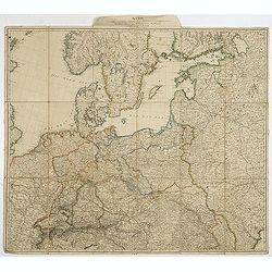
Carte d'Allemagne dressee sur les observations astronomiques et geographiques. . .
Uncommon map published by Dezauche after G. de l'Isle however updated according the Treaty of Paris of 1815, who was signed on 20 November 1815 following the defeat and s...
Date: Paris, 1829
Selling price: ????
Please login to see price!
Sold in 2012
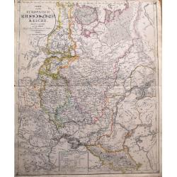
Charte von dem Europaeisch-Russischen Reiche...
Highly detailed map of Eastern Europe, from Finland to the Caspian Sea, centered on Moscow. Includes the Baltic's and the Ukraine. With a legend indicating the number of ...
Date: Leipzig, 1829
Selling price: ????
Please login to see price!
Sold in 2014
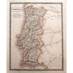
Portugal.
Large and detailed steel-engraved map of Portugal with original outline handcoloring. A fine map, nicely engraved. Extends to show the Spanish cities of Vigo, Truxillo, C...
Date: London, 1829
Selling price: ????
Please login to see price!
Sold in 2014
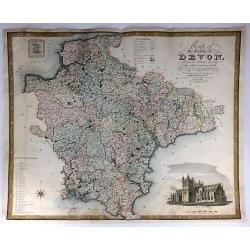
Map of the County of Devon, from an Actual Survey, Made in the Years 1825 & 1826
A very large map of the County of Devon by Christopher Greenwood, published by Greenwood & Co. It has an inset views of Exeter Cathedral and Lundy Island. The brother...
Date: London, 1829
Selling price: ????
Please login to see price!
Sold in 2016
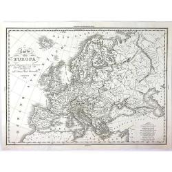
Carta Dell' Europa da Fare d'llustrazione al Nuovo Dizionario Geografico Universale....
A strikingly attractive and detailed copper engraved map of Antonelli's 1829 map of the whole European Continent. This large map provides excellent topographic details on...
Date: Venice, 1829
Selling price: ????
Please login to see price!
Sold in 2016
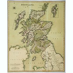
Scotland.
Large folding map of Scotland, published by Henry Teesdale in London. In full body color. Map is detailed with many cities, towns and villages, lochs, main roads, and mou...
Date: London, ca 1829
Selling price: ????
Please login to see price!
Sold in 2018
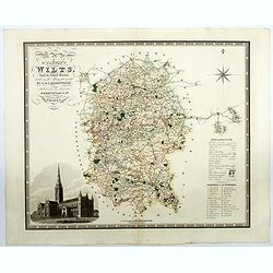
Map of the County of Wilts from an actual survey in the years 1919 & 1820. . .
A superb large scale map of the county of Wiltshire published by the Greenwood brothers. The brothers were surveyors and publishers and undertook the survey of most of th...
Date: London, 1829
Selling price: ????
Please login to see price!
Sold in 2021
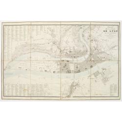
Plan de la Ville de Lyon, et ses environs, réduit d'apres les meilleurs levés, corrigé, augmenté et gravé d'après des plans particuliers et des reconoissances faites sur les lieux.
With the title at upper right, an alphabetical street index at upper left, an index of other features at lower left and right, and a scale of metres at lower right, the r...
Date: Lyon, chez Midan libraire, 1830
Selling price: ????
Please login to see price!
Sold

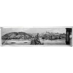
Vue de Vienne prise du cote du chateau de Schonbrunn.
Spectacular view of Vienna. Engraved by Schwartz, after a design of Hügl. Published by Bannee & Schrot, active in Rue du Mail, Paris.
Date: Paris c.1830
Selling price: ????
Please login to see price!
Sold
![[No title] Russland. Gouv. 31. Taurien und 31a das Land der Tschernomorkischen Kosaken.](/uploads/cache/28947-250x250.jpg)
[No title] Russland. Gouv. 31. Taurien und 31a das Land der Tschernomorkischen Kosaken.
Map depict the area north of the Black Sea, including the sea of Azov and the cities of Akhmetschet, Kaffa, Jekaterinodar, Kherson, etc.From "W. E. A. von Schliebens...
Date: Leipzig, G. J. Göschen, ca 1825-1830
Selling price: ????
Please login to see price!
Sold in 2013
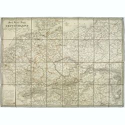
Post Reise Karte durch Deutschlandund die Angraenzenden Staaten. . .
post road maps map of Germany, Poland, the Low Countries, Switzerland and Austria. Folding map dissected in 8 sections, canvas mounted. The map is showing incredible deta...
Date: Vienna, 1830
Selling price: ????
Please login to see price!
Sold in 2011

Vue du Kremlin.
Lithography showing the Kremlin in Moscow.
Date: Paris, 1830
Selling price: ????
Please login to see price!
Sold in 2014
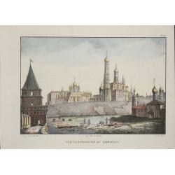
Vue intérieure du Kremlin.
Lithographie shows the Kremlin in Moscow.
Date: Paris, 1830
Selling price: ????
Please login to see price!
Sold in 2014
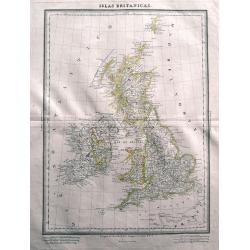
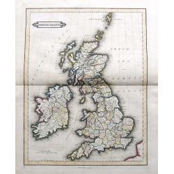
Islas Britanicas.
Very rare Spanish map of the British Isles by Domingo Estrue. With the longitudes east of Madrid. Very detailed map with towns, areas, roads, and many islands shown. Thi...
Date: Madrid, 1830
Selling price: ????
Please login to see price!
Sold in 2014
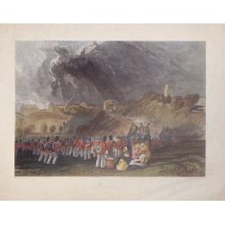
Winchelsea, Sussex.
Hand-colored steel engraving by J. Henshell after J.M.W. Turner featuring a scene of Winchelsea, Sussex.
Date: London, 1830
Selling price: ????
Please login to see price!
Sold in 2016
![[No title, showing Majorca, minorca and part of the coast of Algaria.]](/uploads/cache/35723-250x250.jpg)
[No title, showing Majorca, minorca and part of the coast of Algaria.]
Very detailed folding map with map of Majorca, Minorca and part of the coast of Algeria. In upper left Spanish coast with Barcelona.
Date: France, c.1830
Selling price: ????
Please login to see price!
Sold in 2015
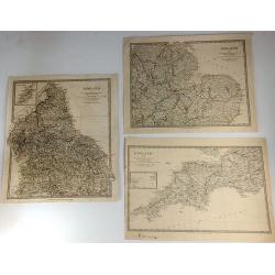
Three S.D.U.K. Maps - England I, England III & England IV
Three detailed maps of England by S.D.U.K. published in London in 1830 by Chapman & Hall and engraved by John Walker. “England I” covers Northumberland, Cumberla...
Date: London, 1830
Selling price: ????
Please login to see price!
Sold in 2016
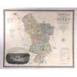
Map of the County of Derby, from an Actual Survey made in the Years 1824 & 1825. By C. & I. Greenwood.
A large map with decorative title at upper right, and a large vignette view of Chatsworth House at lower left. Published by Greenwood & Co. in London in 1830. Engrav...
Date: London, 1830
Selling price: ????
Please login to see price!
Sold in 2016
Lengyel Fold
Small Hungarian map of Poland and Lithuania. Major cities and towns depicted in red, mountains, rivers, woodlands and forests are also highlighted in color.
Date: ca. 1830
Selling price: ????
Please login to see price!
Sold in 2016
Prag (without a title).
A rare, fascinating view of Prag, from the "Buchhandlung of A. Borroschs", engraved by J. Hyrtl in Vienna, 1830.
Date: Vienna, 1830
Selling price: ????
Please login to see price!
Sold in 2018
Karte des mittlern und östlichen Europa, von der Seine bis an der Dnieper. . .
Detailed map of the north west of Europe centered on Poland and Lithuania. The map is prepared by D.G. Reymann and published in Berlin by Simon Schropp & Co.A road sy...
Date: Berlin, ca. 1830
Selling price: ????
Please login to see price!
Sold in 2018
British Islands
Daniel Lizars fine map of the British Isles, pubslished by his son William Hole Lizars. With main roads, counties, cities, etc.
Date: Edinburgh, ca. 1830
Selling price: ????
Please login to see price!
Sold in 2019
Russian Empire / Chart of the communication between the archipelago and Black Sea.
Large 2-sheet map (from 4 plates) of the Russian Empire, pubslished by Daniel Lizars son, William Hole Lizars. The unusual map shows Russia in great detail with many plac...
Date: Edinburgh, ca 1830
Selling price: ????
Please login to see price!
Sold in 2019
Plan de la Bataille de Kliszow.
A lithographed plan of the Battle of Kliszów, which took place on July 19, 1702 in Ma Opolska during Great Northern War. The Swedish army, under command of Charles XII,...
Date: Paris, ca 1830
Selling price: ????
Please login to see price!
Sold in 2021
![England [sheet IV].](/uploads/cache/44907-250x250.jpg)
England [sheet IV].
A single sheet (4) from a larger set of maps comprising England & Wales, produced for the Society for the Diffusion of Useful Knowledge (S.D.U.K.) in London in 1830. ...
Date: London, 1830
Selling price: ????
Please login to see price!
Sold in 2020
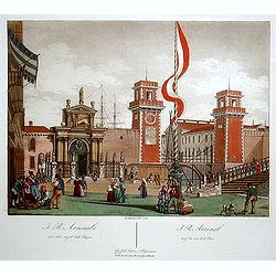
J.R. Arsenale (Venice)
A superbly hand colored aquatint depicting the arsenal of Venice. It provides an excellent view of the architecture. Quite decorative.
Date: Venic, 1831
Selling price: ????
Please login to see price!
Sold in 2011
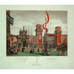
J.R. Arsenal. (Venice)
Superbly hand colored aquatint showing the arsenal of Venice. It provides a lovely view of the architecture.
Date: Venice 1831
Selling price: ????
Please login to see price!
Sold
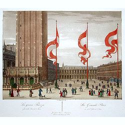
La Grande Place. (Venice)
"Superbly hand colored aquatint showing the ""Grande Place"" of Venice. It provides a lovely view of the architecture and the people walking in f...
Date: Venice 1831
Selling price: ????
Please login to see price!
Sold
Carta Topografica del lago di como e delle tre-Pievi.
A uncommon postal map centered on the lake of Como. Engraved by Giuseppe Pezze.
Date: Milan, c. 1831
Selling price: ????
Please login to see price!
Sold in 2011
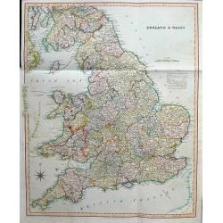
England & Wales
Large and highly detailed map of England & Wales, from Edinburgh to the French coast. Includes ferries to Ireland and Isle of Man, streets with distances between town...
Date: London, 1831
Selling price: ????
Please login to see price!
Sold in 2016
Russian empire. / Chart of the communication between the archipelago and black sea.
Printed on 2 sheets, each sheet has two maps printed from different copper plates. The lower map at 1:400,000 scale and includes northern part of the Black Sea with, Hell...
Date: Edinburg, 1831
Selling price: ????
Please login to see price!
Sold in 2014
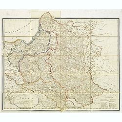
Charte von Polen nach seiner gegenwärtigen Eintheilung in das neue Königreich Polen, die übrigen russischen Besitzungen, das preussische. . . 1831
Rare folding case map of Poland and Lithuania for the year 1831. Very detailed, including a road system and a key in lower right corner. Published in Vienna, by the cousi...
Date: Vienna, 1831
Selling price: ????
Please login to see price!
Sold in 2012
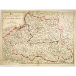
Carte des Etats de Pologne et du Grand Duché de Lithunanie.
Uncommon map of Poland prepared by Eustache Hérisson (1759-18.. ) and engraved by Cordier. The map was published by the last family member of the Jean publishing firm of...
Date: Paris, 1831
Selling price: ????
Please login to see price!
Sold in 2013