Browse Listings in Europe
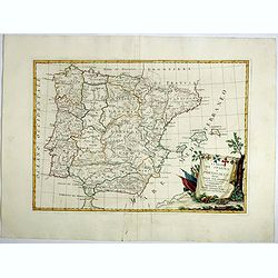
Li Regrni di Spagna E Portogallo . . .
Map of Spain and Portugal from "Atlas Novissimo" printed in Venice between 1776 and 1785. The map was issued in Zatta's Atlas Novissimo a monumental four volume...
Date: Venice, 1775
Selling price: ????
Please login to see price!
Sold in 2017
L'Estremadura e la Castiglia Nuova . . .
Map of the regions of Castille and Estremadura regions of west/central Spain by Antonio Zatta. The cities of Madrid and Toledo are depicted, as is the western border of P...
Date: Venise, 1775
Selling price: ????
Please login to see price!
Sold in 2018
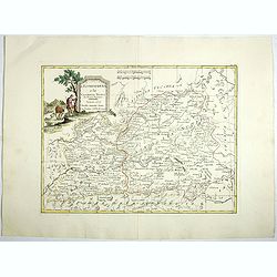
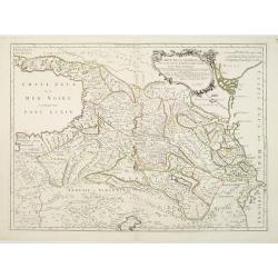
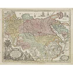
Rare Russian Map (Untitled).
Very interesting, rare, Russian map including parts of the Sverdlovsk and Rostov Oblests (Russian provinces or states). Including parts of the Black and Azov Seas. This...
Date: Russia, 1775
Selling price: ????
Please login to see price!
Sold in 2017
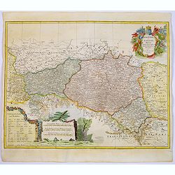
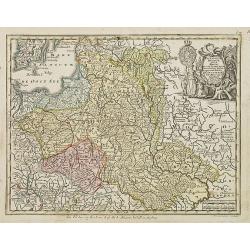
Lubomeriae Et Galliciae Regni Tabula Geographica: Cum Priv. Sac. Caes. Maiestatis Impensis Homannianorum Haeredum . . .
A rare map of the Kingdom of Galicia and Lodomeria prepared by F.L. Güssefeld, (1744-1808), who was a cartographer from Osterburg, studied at Brandenburg, worked in Weim...
Date: Nuremberg, 1775
Selling price: ????
Please login to see price!
Sold in 2017
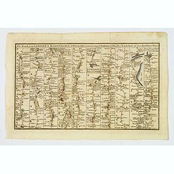
The Road from London to Barnstable, in Devonshire, commencing at Andover, in the road to the Lands End, also from Barnstable to Truro.
A highly detailed late eighteenth century road map, running left to right, commencing at Andover in Hampshire and continuing on to Barnstable in north Devonshire. The map...
Date: London, 1775
Selling price: ????
Please login to see price!
Sold in 2021

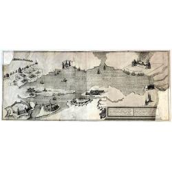
A General View of the City of London, next the River Thames | Vue Generale de la Ville de Londres, du côté de la Tamise.
Rare bird's eye view of London with an imense amount of details, buildings, ships, etc. Shows the Tower on the right, old London Bridge in the centre with the Monument to...
Date: London, 1775
Selling price: ????
Please login to see price!
Sold in 2019
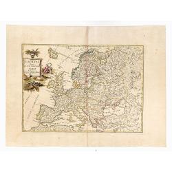
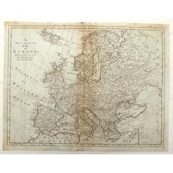
L'Europa divisa Ne Suoi Principali Stati.
Original outline color, with decorative colored title cartouche to upper left corner. Double page map of Europe. Blank on verso.
Date: Venice, 1775
Selling price: ????
Please login to see price!
Sold in 2020
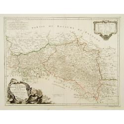
Carte de la Pologne Autrichienne Contenant La Russie Rouge et la partie méridionale du Palatinat de Cracovie..
Detailed map of Poland, showing the area east of Krakow until Ukraine.Santini gives credit to Homann Heirs in the cartouche.
Date: Venise 1776
Selling price: ????
Please login to see price!
Sold
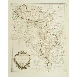
Carte de la Lithuanie Russienne qui comprend les Palatinats de Livonie de Witepsk, de Miscislaw..
Detailed map of Belarus, Latvia with the river Dnepr. Included are towns as Smolensk, Orsa, Minsk, etc.Santini gives credit to Homann Heirs in the cartouche. °
Date: Venise 1776
Selling price: ????
Please login to see price!
Sold
Carte de la Pologne Autrichienne contenant La Russie Rouge et la partie méridionale du Palatinat de Cracovie ..
Detailed map with Krakow, including the areas of Malopolskie and Podkarpackie and including present-day Ukraine.Santini gives credit to Homann Heirs in the cartouche. Mal...
Date: Venise, 1776
Selling price: ????
Please login to see price!
Sold in 2008
Carte de la Géorgie &c. des pays situés entre la Mer Noire et la Mer Caspienne..
Detailed map of Georgia, Armenia and Azerbaijan.Santini gives credit to Homann Heirs in the cartouche.
Date: Venise 1776
Selling price: ????
Please login to see price!
Sold
Carte de la Lithuanie Russienne qui comprend les Palatinats de Livonie, de Witepsk, de Miscislaw, et un partie de ceux de Polock et de Minsk..
Detailed map of the areas along the river Dnieper and Duna.Santini gives credit to Homann Heirs in the cartouche.
Date: Venise, 1776
Selling price: ????
Please login to see price!
Sold in 2012
Carte de la Lithuanie Prussienne qui comprend les Palatinats de Livonie, de Witepsk, de Liscislaw, et une partie de ceux de Polock et de Minsk cédés par la Pologne à la Russie. Dressée sur l'Exemplaire des Héritiers Homann 1775.
Detailed map of the areas along the river Dnieper and Duna. Santini gives credit to Homann Heirs in the cartouche.The map was prepared by the Venetian cartographer and pu...
Date: Venice, 1776
Selling price: ????
Please login to see price!
Sold in 2009
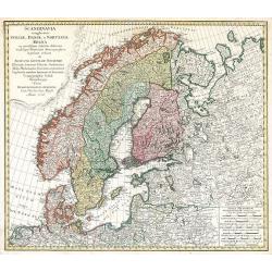
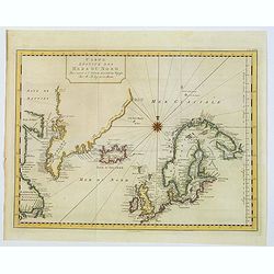
Scandinavia complectens Sveciae, Daniae et Norvegiae Regna ...
Scandinavia by Homann Heirs
Date: Nuremberg, 1776
Selling price: ????
Please login to see price!
Sold in 2009
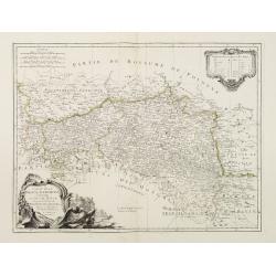
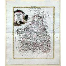
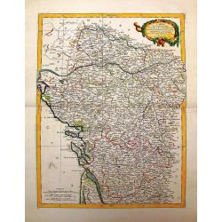
Li Governi di Guyenna e Guascogna con quello di Bearn e Bassa Navarra
Map of the Bourdeaux region of France, including the cities of Bourdeaux, Marmande, Tonneins, and Bayonne. To the south, the Navarra region of Spain along with the Pyrene...
Date: Venice, 1776
Selling price: ????
Please login to see price!
Sold in 2010
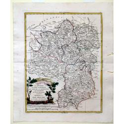
Li Governi del Limosin, Quercy, E Preigord Di Nuoca Projezione.
Map of the regions Limousin, Quercy and Périgord in southwest France different colors are used to outline the three regions and the titles in bold lettering further dist...
Date: Venice, 1776
Selling price: ????
Please login to see price!
Sold in 2010
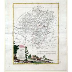
Li Governi del Berri, del Nivernois, della Marche, del Bourbonnois e dell \'Auvergne Di Nvoua Projezione.
Map of five regions in central France including the province Berry, most famous for the 14-15th century illuminated manuscript, "Les Trés Riches Heures du Dec de Be...
Date: Venice, 1776
Selling price: ????
Please login to see price!
Sold in 2010
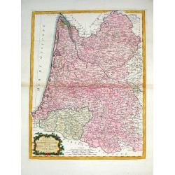
Li Governi Di Lorenza, Barr, ed Alsazia Di Nuova Projecione.
Map of three regions in northeastern France: Barrois, Lorraine and Alsace. Barrois is a "pays" and in the Middle Ages the region was a part of the duchy of Bar....
Date: Venice, 1776
Selling price: ????
Please login to see price!
Sold in 2010
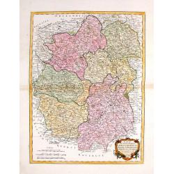
Li Governi dell\'Isola Di Francia ED Orleanois Di Nuova Projezione.
Map of the region surrounding Orleans France by Antonio Zatta. Map includes major cites such as Chartres, Fontainebleau and Beauvais and rivers systems. A bold cartouche ...
Date: Venice, 1776
Selling price: ????
Please login to see price!
Sold in 2010
Li Governi della Fiandra Francese, d\'Artois, di Picardia, del Boulonois di Nuova Projezione.
Map of Northern France by Antonio Zatta. This wonderfully detailed composition includes major cites such as Calais, Abbeville, and Dunkirk, and the northern coastline of ...
Date: Venice, 1776
Selling price: ????
Please login to see price!
Sold in 2010
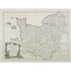
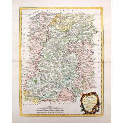
Li Governi di Normandia del Maine e Perche di Nuova Projezione.
Map of the Normandy Coast of France by Antonio Zatta. This detailed map depicts major cities such as Rouen, Ambriere and Mortagne, and the off coast islands of Jersey, Gu...
Date: Venice, 1776
Selling price: ????
Please login to see price!
Sold in 2010
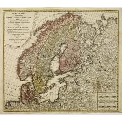
Scandinavia complectens sueciae, Daniae et Norvegiae. . .
Detailed map of Scandinavia, covering Sweden, Denmark, and Norway. Published by the Homann Heirs.
Date: Nuremberg, 1776
Selling price: ????
Please login to see price!
Sold in 2011
L'Estremadura e la Castiglia Nuova Di Nuova Projezione. . .
Map of the regions of Castille and Estremadura regions of west/central Spain by Antonio Zatta. The cities of Madrid and Toledo are depicted, as is the western border of P...
Date: Venice, 1776
Selling price: ????
Please login to see price!
Sold in 2010
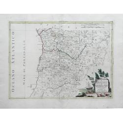
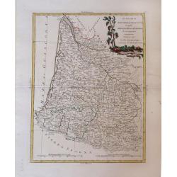
Il Portogallo Cioe le Provincie di Entredouro, e Minho, Traz-os-Montes, e Beira Di Nuova Projezione. . .
Map of the provinces of Minho, Biera, Tras-os-Montes e Alto Duoro and Beira, of northern Portugal, by Antonio Zatta. Towns, villages, forests, mountains and rivers of the...
Date: Venice, 1776
Selling price: ????
Please login to see price!
Sold in 2010
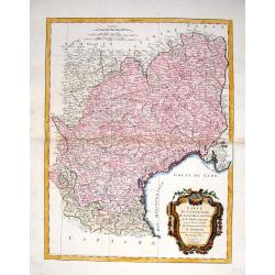
Carte du Gouvernement de Champagne et Brie
This large, very detailed, copper engraved map of French provinces is based on the earlier map by Bonne. It shows forests, cities, towns, mountains and roads and is decor...
Date: Venice, 1776
Selling price: ????
Please login to see price!
Sold in 2014
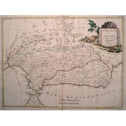
Andalusia e Granada Di Novissima Projezione.
Double page map of Southern Spain with the cities of Seville, Granada and Malaga and including Gibraltar. The pictorial title cartouche shows a farmer with his cattle. Fr...
Date: Venice, 1776
Selling price: ????
Please login to see price!
Sold in 2017
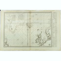
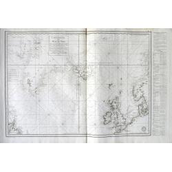
Carte réduite des Mers du Nord Comprise entre le 48° et le 72° Degré de Latitude Septle et entre le lle Degré de Longitude Orientale et le 61e. . .
Uncommon sea of the North Atlantic, published by the French Dépot de la Marine. Including the coasts of Scandinavia, the Baltic Sea, British Isles, Iceland, Greenland a...
Date: Paris, 1776
Selling price: ????
Please login to see price!
Sold in 2018
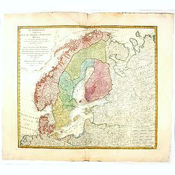
Scandinavia complectens sueciae, Daniae et Norvegiae. . .
A detailed map of Scandinavia covering Sweden, Denmark, and Norway. Published by the Homann Heirs.
Date: Nuremberg, 1776
Selling price: ????
Please login to see price!
Sold in 2019
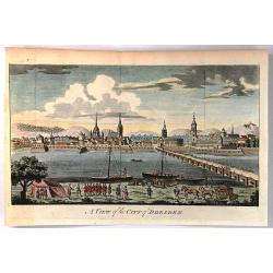
A view of the City of Dresden
Engraved city view looking across the river to Dresden. Military and commercial activities are shown on the near shore with many buildings on the far shore of the Elber R...
Date: London, 1776
Selling price: ????
Please login to see price!
Sold in 2016
Carte Réduite des Mers du Nord . . .
A highly interesting large-scale sea chart of the North Atlantic. Extends from Labrador until Sweden. Shows the coasts of Scandinavia, the Baltic Sea, British Isles, Icel...
Date: Paris, 1776
Selling price: ????
Please login to see price!
Sold in 2018
Li Governi di Guyenne e guascogna con quello de Bearn e Bassa Navarra. . .
A map of the Bordeaux region of France, including the cities of Bordeaux, Marmande, Tonneins, and Bayonne. To the south, the Navarra region of Spain along with the Pyrene...
Date: Venice, 1776
Selling price: ????
Please login to see price!
Sold in 2021
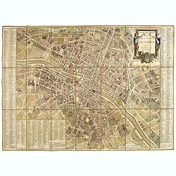
Plan routier de la Ville et Faubourg de Paris.
Grid plan. On both sides of the map, an alphabetical map of the streets Updates: North, opening of Thiroux Street, new name of St. Anne Street, which becomes rue Poissonn...
Date: Paris, 1776
Selling price: ????
Please login to see price!
Sold
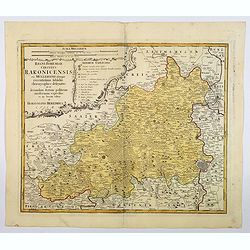
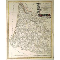
Regni Bohemiae Circulus Rakonicensis . .
A nice large-scale map of the Rakovnik region, north and west of Prague in the Czech republic. Published by Homann Heirs in the mid-eighteenth century in Nuremberg. From ...
Date: Nuremburg, 1776
Selling price: ????
Please login to see price!
Sold in 2021
Carte Reduite des Mers du Nord. . .
A scarce example of this attractive chart of the north Atlantic, including, Scandinavia, Iceland, Greenland, parts of Canada &c., from Prevost's 'Histoire Generale de...
Date: Amsterdam, 1776
Selling price: ????
Please login to see price!
Sold in 2019
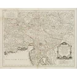
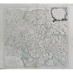
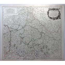
Partie Meridionale du cercle D'Autriche. . .
Uncommon, finely and crisply engraved map with large decorative title cartouche.Very detailed sheet that is centered roughly on Trieste and extends in to the mouth of the...
Date: Venice 1777
Selling price: ????
Please login to see price!
Sold in 2017
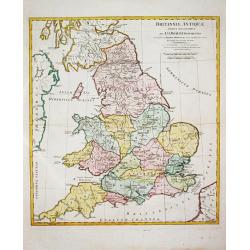
Brittanniae Antiquae Tabula Geographica.
John Horsley's map of antique England, published in ' A Complete Body of Ancient Geography'.
Date: London, R. Sayer and J. Bennett, 1777
Selling price: ????
Please login to see price!
Sold in 2011
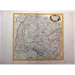
Carte du Gouvernement de Normandie avec celui du Maine et Perche projettée et assujettie aux observat. À Paris par M. Bonne Mtre Mathémat. À Paris 1771.
A general map of Normandy, Maine and Perche describing these different regions. Published by P. Santini map, an Italian map publisher who worked in Venice. Notable works...
Date: Venice, 1777
Selling price: ????
Please login to see price!
Sold
Li Governi Di Sciampagna E Brie Di Nuiva Projezione
This map of France highlights the Champagne and Brie regions in the northeastern part of the country. Each of these cities derives their names from the sparkling wine and...
Date: Venice, 1777
Selling price: ????
Please login to see price!
Sold in 2010
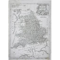
A New and Accurate Map of England. . .
A finely detailed, small scale map of England by Thomas Bowen. Emmanuel Bowen was one of the leading English mapmakers of the eighteenth-century, and was cartographer to ...
Date: London, c.1777
Selling price: ????
Please login to see price!
Sold in 2010
Carte dy Gouvernement de L'Isle de France et de L'Orleanois
A large, beautiful map of France's most populous province, centered around Paris. It is decorated by a large title cartouche. Francois [Francesco] Santini was a Venetian...
Date: Venice, 1777
Selling price: ????
Please login to see price!
Sold in 2014
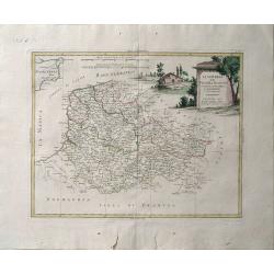
Carte des Gouvernements D'Anjou et du Saumurois.
A beautiful example of Rigobert Bonne's decorative map of the famous French "Chateau" wine-making region, hugging the Loire Valley. It was included in Santini's...
Date: Venice, 1777
Selling price: ????
Please login to see price!
Sold in 2015
Carte du Gouvernement de Guienne et Gascogne avec Celui de Bearn et Basse Navarre.
Striking Venetian edition of a copper engraved map of Guyenne and Gascogne in southwestern France, the home of Armagnac and Foie Gras. Bonne created the map. Francois or ...
Date: Vienna, 1777
Selling price: ????
Please login to see price!
Sold in 2014
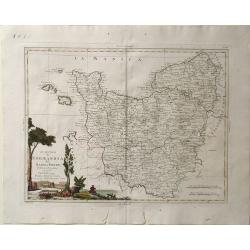
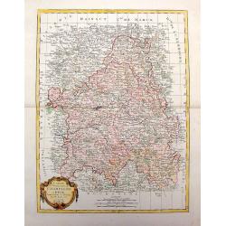
Carte des Gouvernements de Languedoc, de Foix et de Roussillon.
Striking large copper engraved map of the governments of Languedoc, Roussiloon de Foix and eastern Guienne. Lovely colorful floral title cartouche. Francois or Paolo Sa...
Date: Vienna, 1777
Selling price: ????
Please login to see price!
Sold in 2013
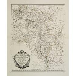
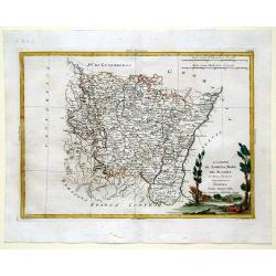
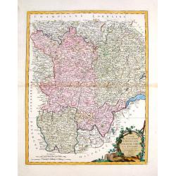
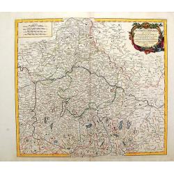
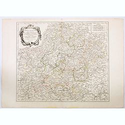
Carte des Gouvernements du Berri, du Nivernois, de la Marche, du Bourbonnois, du Limosin et de L'Auvergne.
Striking large map of central France including Limoges, Moulins. It was based on a smaller map by R. Bonne in 1771. It features a Rococco cartouche. Francois or Paolo San...
Date: Venice, 1777
Selling price: ????
Please login to see price!
Sold in 2016
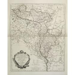
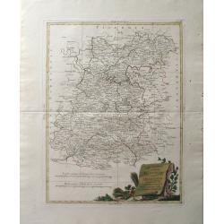
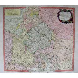
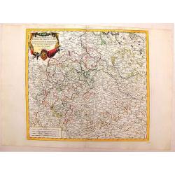
Carte des Gouvernements de Bourgogne, de Franche Comte et de Lyonnois.
Impressive large map of French provinces, including Lyon, Dijon, and Besancon, and the border with Switzerland. It was based on a smaller map by Bonne in 1771. It feature...
Date: Venice, 1777
Selling price: ????
Please login to see price!
Sold in 2014
A New & Accurate Map of Europe, Drawn from the best Authorities.
Detailed map of Europe engraved by Thomas Bowen for "BANKES'S NEW SYSTEM OF GEOGRAPHY" in LONDON IN 1777. Iceland is oversized.
Date: London, 1777
Selling price: ????
Please login to see price!
Sold in 2017
An Accurate Map of the County of Monmouth, Divided Into Hundreds
This attractive map of the county of Monmouth identifies major roads, villages, churches, and castles, it is by Emanuel Bowen, and was published for Robert Sayer in Londo...
Date: London, 1777
Selling price: ????
Please login to see price!
Sold in 2017
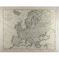
A New & Accurate Map of Europe, Drawn from the Best Authorities.
A fine engraved map including all of Europe, Iceland, the Mediterranean, and the Barbary Coast, by Thomas Bowen in England in 1777. From “A New & Accurate Map of E...
Date: London, 1777
Selling price: ????
Please login to see price!
Sold in 2018
Carte de la Republique des Suisses.
A fine detailed map of Switzerland featuring the cantons. The map was engraved by J.E.. Hauman in Paris in 1777, and was published by Chez Mondhare. The map features a de...
Date: Paris, 1777
Selling price: ????
Please login to see price!
Sold in 2019
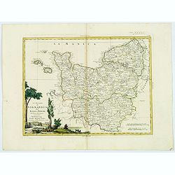
Li Governi di Normandia del Maine e Perche. . .
An attractive map that encompasses all of Normandie with the semi-autonomous English Channel Islands islands of Alderney, Jersey & Guernsey, Maine in the French provi...
Date: Venice, 1777
Selling price: ????
Please login to see price!
Sold in 2021

Li Governi di Normandia del Maine e Perche.
A pleasant map shows all of Normandie with its islands: Maine in the french province of Pays de la Loire and Berche in the region of Bourgogne-Franche-Comté. Features a...
Date: Venice, 1777
Selling price: ????
Please login to see price!
Sold in 2023
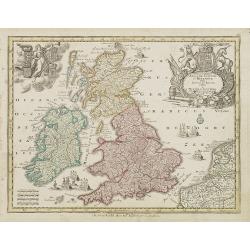
Accuratiffima Angliae Scotiae et Hiberniae. . .
Miniature map of the United Kingdom with Scotland and Ireland, a reduction of Seutter''s folio map.From Atlas Minor, here published by Johann Martin Will, with his addres...
Date: Augsburg, J.M.Will, 1778
Selling price: ????
Please login to see price!
Sold in 2023
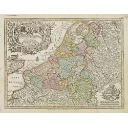
XVII Provinciae Belgii five Germaniae inferioris. . .
Miniature map of the Belgium, Luxemburg, the Netherlands, a reduction of Seutter''s folio map.From Atlas Minor, here published by Johann Martin Will, with his address in ...
Date: Augsburg, J.M.Will, 1778
Selling price: ????
Please login to see price!
Sold in 2008
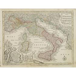
Nova totius Italiae cum adjecentibus majoribus et minorib Insulis. . .
Miniature map of Italy, a reduction of the appropriate part of Seutter''s folio map of the Americas, drawn by Albert Seutter. An unusual looking map, its projection givin...
Date: Augsburg, J.M.Will, 1778
Selling price: ????
Please login to see price!
Sold in 2022
Regni Hungariae. . .
Miniature map of Hungary.From Atlas Minor, here published by Johann Martin Will, with his address in bottom center of the map.The cartouche is left uncolored in order to ...
Date: Augsburg, J.M.Will, 1778
Selling price: ????
Please login to see price!
Sold in 2022
Polonia regnum ut et magni Ducat Lithuania. . .
Miniature map of Poland, a reduction of the appropriate part of Seutter's folio map. Engraved by Tobias Conrad Lotter.From Atlas Minor, here published by Johann Martin Wi...
Date: Augsburg, J.M.Will, 1778
Selling price: ????
Please login to see price!
Sold in 2009
Imperium Russiae Magnae. . .
Miniature map of Russia, a reduction of the appropriate part of Seutter's folio map.From Atlas Minor, here published by Johann Martin Will, with his address in bottom cen...
Date: Augsburg, J.M.Will, 1778
Selling price: ????
Please login to see price!
Sold in 2008
Imperium Romano Germanicum. . .
Miniature map of the German Empire, a reduction of Seutter''s folio map.From Atlas Minor, here published by Johann Martin Will, with his address in bottom center of the m...
Date: Augsburg, J.M.Will, 1778
Selling price: ????
Please login to see price!
Sold in 2008
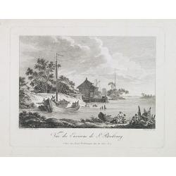
Vue des environs de St. Petersbourg.
Engraved by de Menchy after a drawing made after nature by Le Prince.
Date: Paris, 1778
Selling price: ????
Please login to see price!
Sold in 2009
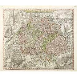
Nova Totius Helvetiae cum suis subditis ac sociis tab. Geogr. . .
Detailed map of Switzerland divided up it its cantons. This one of the most decorative maps of Switzerland published in the eighteenth century, with many engraved place n...
Date: Augsburg, 1778
Selling price: ????
Please login to see price!
Sold in 2011
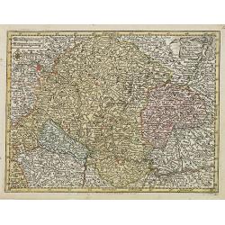
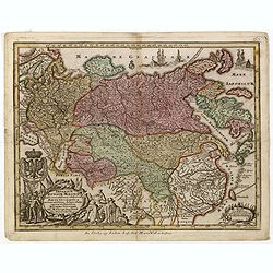
Le Cercle de Baviere...
Attractive copper-engraved map of lower Bavaria. Extends to show parts of Austria and the Czech Republic. Shows the area between Pilsen, Linz, Bayreuth, Ingolstadt, Salzb...
Date: Venice, 1778
Selling price: ????
Please login to see price!
Sold in 2011
Le Cercle de Baviere.
Fine copper engraved map of Baveria and Austria featuring Salzburg, Passau, Ingollstat & Regensberg. It is from the Italian edition of Vaugondy's map from "Atlas...
Date: Venice, 1778
Selling price: ????
Please login to see price!
Sold in 2015
Duche de Savoye qui comprend le Chablais, le Fossigny, Le Genevois...
Fine map of the area, extending from Lake Geneva southwards, including Aosta, Aix-les-Bains, Chambéry, Annecy, Chamonix, etc. Very nice depiction of the mountains and va...
Date: Venice, 1778
Selling price: ????
Please login to see price!
Sold in 2012
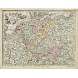
Partie Meridionale du Cercle de Haute Saxe.
Hand Colored map of Upper Saxony in Germany around the city of Leipzig. Also, parts of Czechoslovakia. With a fine decorative title cartouche. From the Italian edition of...
Date: Venice, 1778
Selling price: ????
Please login to see price!
Sold in 2014
Cercle de Souabe.
Large, highly detailed map of Swabia, Germany, flanked with western Austria and part of Switzerland. From the Italian edition of Vaugondy's map. Decorated with fine Rococ...
Date: Venice, 1778
Selling price: ????
Please login to see price!
Sold in 2016
Imperium Russiae Magnae. . .
Miniature map of Russia, a reduction of the appropriate part of Seutter's folio map.From Atlas Minor, here published by Johann Martin Will, with his address in bottom cen...
Date: Augsburg, J.M.Will, 1778
Selling price: ????
Please login to see price!
Sold in 2015
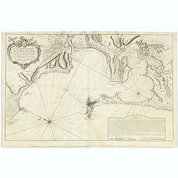
Carte Hydrographique de la Baye de Cadix.
Sea of the Bay of Cadix .Relief shown by hachures. Depths shown by soundings. Below engraved seal of Depot General de la Marine. Prepared under the direction of Duc de C...
Date: Paris, 1778
Selling price: ????
Please login to see price!
Sold in 2018
Le Cercle de Baviere. . .
A pleasant Bavarian map showing the area north (to Bayreuth) and south (to Kitzbühel) of the Danube between Dillingen in the west and Grein in the east. Decorative title...
Date: Paris, 1778
Selling price: ????
Please login to see price!
Sold in 2019
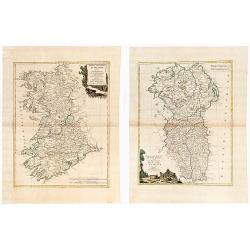
(IRELAND). Parte Del Regno D'Irlanda, cioe' Le Provincie D'Ulster, E Leinster. / Parte Del Regno D'Irlanda, cio+¿ Le Provincie Di Connaught, E Munster Di Nuova Projezione.
Together 2 sheets. Each image c. 31 x 41 cm. Original outline color, both with decorative colored title cartouches. Ireland shown on two double page maps. The first map s...
Date: Venice: Antonio Zatta. 1778
Selling price: ????
Please login to see price!
Sold in 2020
Cercle de Franconie qui comprend Les Eveches de Wurtzbourg. . .
A striking and highly detailed copper engraved map depicting a section of the German region of Franken (Franconia). The map gives several details concerning cities, villa...
Date: Venice, 1778
Selling price: ????
Please login to see price!
Sold in 2021
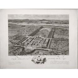
Plan perspective de l'École royale militaire.
A decorative bird's eye view of the complex of the French military school in Paris.
Date: Paris, 1778
Selling price: ????
Please login to see price!
Sold in 2022
Nova Totius Helvetiae cum suis subditis ac sociis tab. Geogr. . .
Detailed map of Switzerland divided up it its cantons. This one of the most decorative maps of Switzerland published in the eighteenth century, with many engraved place n...
Date: Augsburg, 1778
Selling price: ????
Please login to see price!
Sold in 2021
Vista oriental de la ciudad de Chinchilla.
Scarce city view from "ATLANTE ESPAÑOL - Don Bernardo Espinalt y Garcia" engraved by Palomino, showing Chinchilla de Monte Aragón in Albacete. Numerous buildi...
Date: Madrid, 1779
Selling price: ????
Please login to see price!
Sold
Vista oriental de la ciudad de Villena.
Scarce city view from "ATLANTE ESPAÑOL - Don Bernardo Espinalt y Garcia" engraved by Palomino, showing Villena, a strategic important city close to Alicante. N...
Date: Madrid 1779
Selling price: ????
Please login to see price!
Sold in 2008
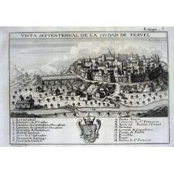
Vista septentrional de la ciudad de Tervel.
Scarce city view from "ATLANTE ESPAÑOL - Don Bernardo Espinalt y Garcia" engraved by Palomino, showing Tervel and its strong city walls. Numerous buildings are...
Date: Madrid, 1779
Selling price: ????
Please login to see price!
Sold
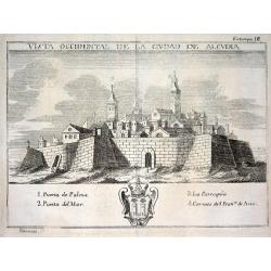
Vista occidental de la ciudad de Alcudia.
Scarce city view from "ATLANTE ESPAÑOL - Don Bernardo Espinalt y Garcia" engraved by Palomino, showing Alcudia, a town in the northern part of the Balearic Isl...
Date: Madrid, 1779
Selling price: ????
Please login to see price!
Sold
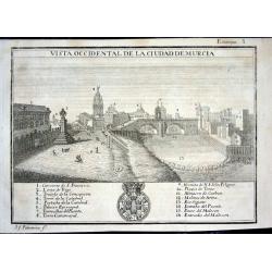
Vista occidental de la ciudad de Murcia
Scarce city view from "ATLANTE ESPAÑOL - Don Bernardo Espinalt y Garcia" engraved by Palomino, showing Murcia as seen from the East. Numerous buildings are nam...
Date: Madrid 1779
Selling price: ????
Please login to see price!
Sold
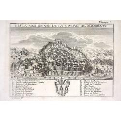
Vista meridional de la ciudad de Albarracin
Scarce city view from "ATLANTE ESPAÑOL - Don Bernardo Espinalt y Garcia" engraved by Palomino, showing Albarracin in Teruel, Aragon. Numerous buildings are nam...
Date: Madrid 1779
Selling price: ????
Please login to see price!
Sold
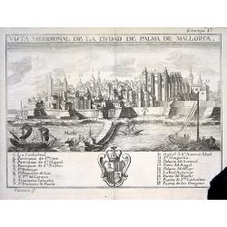
Vista meridional de la ciudad de Palma de Mallorca
Scarce city view from "ATLANTE ESPAÑOL - Don Bernardo Espinalt y Garcia" engraved by Palomino, showing Palma de Mallorca from its seaside including 3 sailing s...
Date: Madrid 1779
Selling price: ????
Please login to see price!
Sold

Mapa del Reyno de Murcia dividido en sus partidos
Scarce map of the area around Murcia from "ATLANTE ESPAÑOL - Don Bernardo Espinalt y Garcia" engraved by Palomino. Includes many placenames, a large title cart...
Date: Madrid 1779
Selling price: ????
Please login to see price!
Sold