Browse Listings in Europe
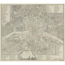
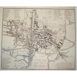
A Plan of the City of Paris.
Nicely detailed 18th century map of Paris, published in A collection of plans of the most capital cities of every empire, kingdom and electorate in Europe and some remark...
Date: London, 1771
Selling price: ????
Please login to see price!
Sold in 2009
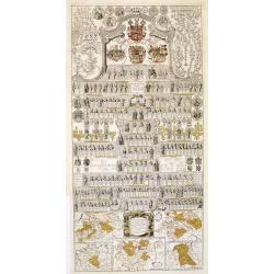
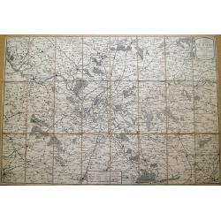
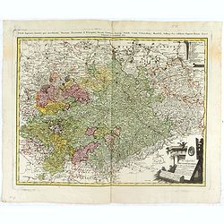
Vorstellung der Sächsischen Historie daraus die ge sämtlichen Regenten.
A decorative plate with hundreds of Kings of Saxony; with in bottom five maps of the region of Saxony during different periods.The map in lower right showing the foundati...
Date: Berlin, 1771
Selling price: ????
Please login to see price!
Sold in 2013
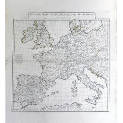
Germanie, France, Italie, Espagne, Isles Britanniques,; Dans un Age intermediaire de l'Anciene Geographie et de la Moderne
A beautiful 18th century map of Europe by Jean Baptiste Bourguignon D'Anville, showing the areas of ancient civilizations of Europe. Areas of ancient civilization shown i...
Date: Paris, 1771
Selling price: ????
Please login to see price!
Sold in 2010
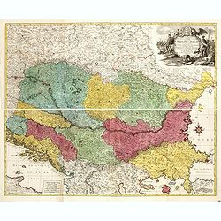
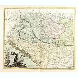
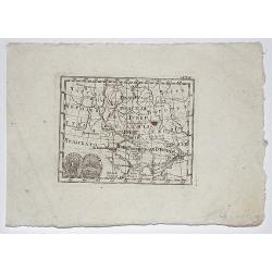
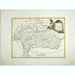
Carte Geographique du Theatre de la Guerre en General representant le Royaume de Hongarie la Principauté de Transylvanie, et les Royaumes de Croacie, de Dalmacie, de Esclavonie, de Bosnie, de Servie . . .
Carte Geographique du Theatre de la Guerre en General representant le Royaume de Hongarie la Principauté de Transylvanie, et les Royaumes de Croacie, de Dalmacie, de Esc...
Date: Augsburg, 1771
Selling price: ????
Please login to see price!
Sold in 2021
Partie Orientale de l'Empire de Russie.
A fine map of eastern Russia by Bonne in Paris in 1771. Published by Chez Lattre. This is one of two maps featuring all of Russia. Features decorative title cartouche.Rig...
Date: Paris, 1771
Selling price: ????
Please login to see price!
Sold in 2017
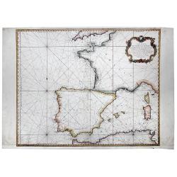
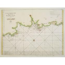
Carte Reduite Des Costes de France, De Portugal, et D'Espagne sur l'Ocean et sur la Mediterranee. 1771.
A detailed chart of the coastline of south western Europe. Coastal detail only, interiors left blank. Decorative cartouche. Rhumb lines , published by the French Hydrogra...
Date: Paris, 1771
Selling price: ????
Please login to see price!
Sold in 2020
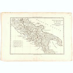
Partie Septentrionale du Royaume de Naples.
Map of the Northern part of the Kingdom of Naples, by Rigobert Bonne.
Date: Paris, 1771
Selling price: ????
Please login to see price!
Sold in 2022
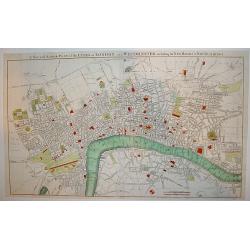
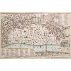
A New and Accurate Plan of the Cities of London and Westminster, including the New Roads & Buildings.
A large, attractive and nicely detailed plan of London as seen in the early 1770?s. A scarce piece.John Andrews produced only a small number of works and is primarily rec...
Date: London, c. 1772
Selling price: ????
Please login to see price!
Sold
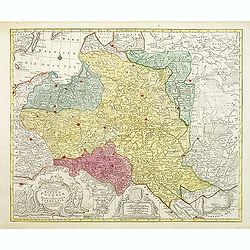
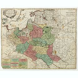
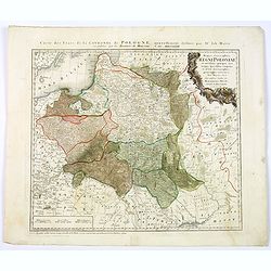
Mappa geographiaca .. regnum Poloniae et .. Lithuaniae ..
Uncommon map of Poland. T.C. Lotter married M. Seutter's daughter in 1740 and succeeded him in 1756. Lotter used the copperplate of Seutter, he only changed the name.
Date: Augsbourg, 1772
Selling price: ????
Please login to see price!
Sold
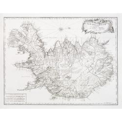
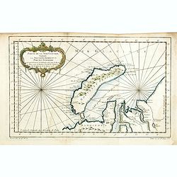
Nyt Carte over Island..
Very rare map of Iceland, important map as it is the first map to show Rekjavik. Engraved by Jonas Haas, signed and dated 1772. Prepared by n, Professor John Erichsen (17...
Date: Aar 1771 - 1772
Selling price: ????
Please login to see price!
Sold
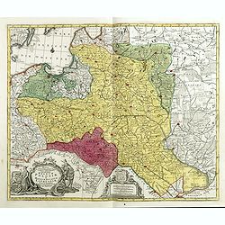
Le ROYAUME de POLOGNE Comprenant les Etats de Pologne et de Lithuanie, divisez en Province et Subdivisez en Palatinats. . .
Extends from about Vienna in the west to east of the Crimea and north to include the present day Baltic States. It includes all of the present day Ukraine.The map was fir...
Date: Paris, ca. 1742 - 1772
Selling price: ????
Please login to see price!
Sold in 2009
Plan de Varsovie levé par ordre de son Exc.e Mr. Le C.te Bielinski grand Maréchal de la couronne didié à son exc.e Mr. Le c.te Wielhorski. . .
Giovanni Antonio Rizzi-Zannoni (1736-1814) published in 1772 in Paris his famous map of Poland. This map was published in the form of an atlas, but could be easily assemb...
Date: Paris, 1772
Selling price: ????
Please login to see price!
Sold in 2009
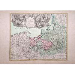
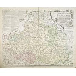
Le Royaume de Prusse Suivant les Nouvelles Observations.
George Louis le Rouge map of northern Poland, showing region along Baltic Sea.
Date: Paris, 1772
Selling price: ????
Please login to see price!
Sold in 2010
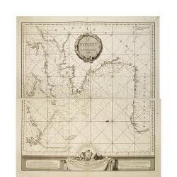
Le Ponant.
in two sheets. The chart depicts the Channel, including a detailed rendering of the south coast of England, the west coast of France and the north coast of Spain, includ...
Date: Le Havre, J.B. Patry, 1772
Selling price: ????
Please login to see price!
Sold in 2010
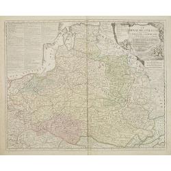
Le ROYAUME de POLOGNE Comprenant les Etats de Pologne et de Lithuanie, divisez en Province et Subdivisez en Palatinats. . .
Extends from about Vienna in the west to east of the Crimea and north to include the present day Baltic States. It includes all of the present day Ukraine. The map was fi...
Date: Paris, ca. 1742 - 1772
Selling price: ????
Please login to see price!
Sold in 2017
XVIII Fle L'indicateur fidele du voyageur François.
Fine post road mapsroad map of the Provence from "L'Indicateur fidèle ou guide des voyageurs, qui enseigne toutes les routes royales et particulières de la France,...
Date: Paris, 1772
Selling price: ????
Please login to see price!
Sold
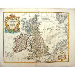
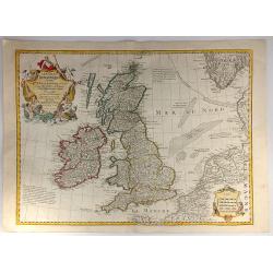
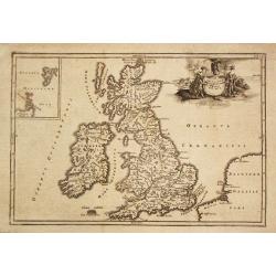
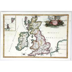
Les Isles Britanniques ou Sont le Royaumes d\'Angleterre .
Showing the British Isles and Ireland. It was published by Phillipe Buache in France in 1772. The map features two large Renaissance cartouches. Guillaume de l'Isle (167...
Date: Paris, 1772
Selling price: ????
Please login to see price!
Sold in 2013
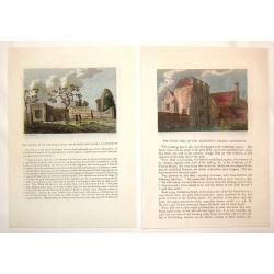
(2 Engravings) The Chapel of St. Pancrace, in St. Augustine's Monastery, Canterbury & The Great hall of the Archbishop's Palace, Canterbury
Two hand-colored, copper engravings of Canterbury architecture from Grose's "The Antiquities of England and Wales". Includes text concerning the location on the...
Date: London, 1772
Selling price: ????
Please login to see price!
Sold in 2016
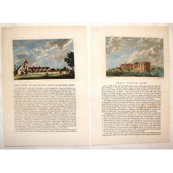
(2 Engravings) Leeds Castle, Kent & The Priory of Davyngton, Neat Faversham, Kent.
Two hand-colored, copper engravings featuring antique architectural buildings in Kent. These Prints are from Grose's "The Antiquities of England & Wales" an...
Date: London, 1772
Selling price: ????
Please login to see price!
Sold in 2016

The Troelfth Cake. - Le Gateau Des Rois ...
A dramatic cartographic curiosity illustrating the division of northern Europe effected by the first partition of Poland, in which the map, shown on a large canvas is tor...
Date: London, 1772
Selling price: ????
Please login to see price!
Sold in 2014
A PLAN OF THE CITY AND LIBERTIES OF LONDON; SHEWING THE EXTENT OF THE DREADFUL CONFLAGRATION IN THE YEAR 1666.
Based on Wenceslaus Hollar's 1666 map of the Great Fire of London. A highly detailed map of the City of London and its environs, designed to show the vast extent of the G...
Date: London, 1772
Selling price: ????
Please login to see price!
Sold in 2015
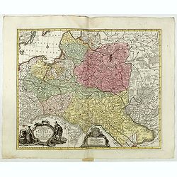
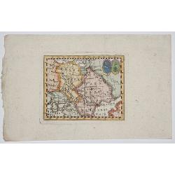
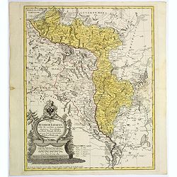
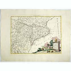
Le Royaume de Hongrie la Transilvanie L'Esclavonie la Croatie et la Bosnie.
Fine map of Hungary, Slovakia, Romania, etc. with a splendid cartouche of an elephant, a crocodile and a canon and canon balls in the forefront and an array of flags amid...
Date: Paris, 1772
Selling price: ????
Please login to see price!
Sold in 2019
Mappa geographiaca ex novisimis observationibus repraesentans regnum Poloniae et Magnum Lithuaniae . . .
Uncommon map of Poland. Tobias Conrad Lotter married Matthias Seutter's daughter in 1740 and succeeded him in 1756. Lotter used the copperplate of Seutter, he only change...
Date: Augsburg, 1772
Selling price: ????
Please login to see price!
Sold in 2015
Mappa Geographica ex novissimis observationibus repraesentans Regnum Poloniae Et Magnum Ducatum Lithuaniae.
Uncommon map of Poland, Latvia, Lithuania, Estonia and Belarus. Below coats of arms of Stanislaw August Poniatowski (1732-1798) the last King and Grand Duke of the Polish...
Date: Augsburg, ca. 1772
Selling price: ????
Please login to see price!
Sold in 2015
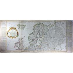
A New and Accurate Map of Europe. Divided into its Empires, Kingdoms, States and Republics. . .
An exceptional example of the top two sheets of this wall map size 4-sheet map of Europe. Includes extensive text and tables on either side of the map. This map of the ...
Date: London, 1772
Selling price: ????
Please login to see price!
Sold in 2016
Les Isles Britanniques ou sont le Rme. d'Angleterre Tire de Sped Celuy d'Ecosse...
Originally issued in 1702 by Delisle, this influential map of the British Isles map has his characteristic crisp style and topographical detail. On the right hand side th...
Date: Paris, 1772
Selling price: ????
Please login to see price!
Sold in 2016
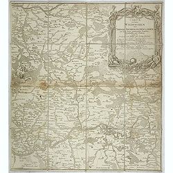
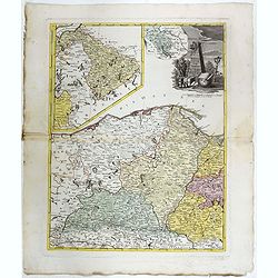
Carte von denen Wiedischen und Nieder Isenburgischen Landen mit den daran gräntzenden Landen, Ortschaften und Flüssen, nebst dem Prospect vom Schloß und Flecken Isenburg. . .
The right hand sheet of a 2-sheet map of Wiedische and Isenburg land. Shows the course of the River Lahn from the mouth into the Rhine near Nassau, Montabaur, Limburg. To...
Date: Frankfurt am Main, 1772
Selling price: ????
Please login to see price!
Sold in 2021
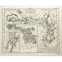
Nouvelle Representation des Cotes Nord et Est de L'Asie. . .
An interesting map with three overlaid maps on one sheet. Shows northern coast of Europe and Asia possibly focusing on the idea of a North East Passage. Japan (Nippon) an...
Date: Paris, 1772
Selling price: ????
Please login to see price!
Sold in 2023
Carte nouvelle du Royaume de Pologne . . .
Uncommon map of the Poland kingdom by Matthieu Albert Lotter (1741-1810), who worked with his father Tobias Conrad and succeeded to his business. Lotter Jr. Gives credit ...
Date: Augsburg, 1772
Selling price: ????
Please login to see price!
Sold in 2019
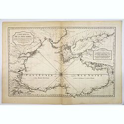
Carte Reduite de la Mer Noire. . .
Bellin's classic chart of the Black Sea that was ordered by M. de Boynes, Secretary of State of the Department of the Navy (Depot de la Marine) for use by official French...
Date: Paris, ca 1772
Selling price: ????
Please login to see price!
Sold in 2019
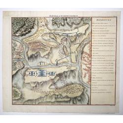
Battle of Stavoutschan.
A beautiful map showing the Battle of Stavutschan during the Russian-Austrian Turkish War (1736-39). Engraved by J. Mynde. From Manstein, Chr. H. v.', "Mémoires his...
Date: London, 1772
Selling price: ????
Please login to see price!
Sold in 2020
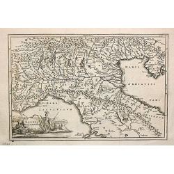
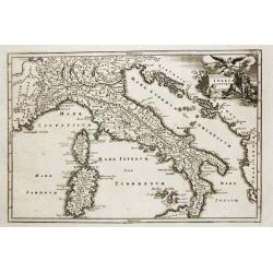
Gallia Cisalpina.
Christoforus Cellearius (1638-1707), geographer. Geographia Antiqua, 1686-1812, Notitia orbis antiquis sive geographia plenior, 1703.A map of northern Italy. From "N...
Date: Leipzig, 1773
Selling price: ????
Please login to see price!
Sold
Insularum Britannicarum Facies Antiqua.
Christoforus Cellearius (1638-1707), geographer. ' Geographia Antiqua', 1686-1812
Date: Leipzig, 1773
Selling price: ????
Please login to see price!
Sold in 2008
Carte des environs de Paris, suivant les nouvelles observations par J. Laurent,...
Highly detailed map of Paris and environs printed by Mondhare. Includes many small villages which are now actually within the Paris city limits... Extends from Vernon an...
Date: Paris, 1773
Selling price: ????
Please login to see price!
Sold in 2013
NEW MAP OF THE CITY OF OXFORD
A scarce 18th century plan of the City of Oxford. The work is finely rendered and contains exceptional detail. Three separate legends identify important town sites. Unive...
Date: London, dated 1773
Selling price: ????
Please login to see price!
Sold
Italia Antiqua.
Christoforus Cellearius (1638-1707), geographer. ' Geographia Antiqua', 1686-1812
Date: Leipzig, 1773
Selling price: ????
Please login to see price!
Sold
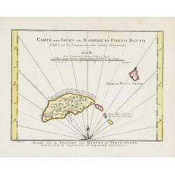
Carte des Isles de Madere et Porto Santo.
An uncommon issue of this very nice map of the Island of Madera and Porto Santo.With French text in title cartouche and an additional title in Dutch underneath the map.
Date: Amsterdam, 1773
Selling price: ????
Please login to see price!
Sold
3. Carte Particuliere Des Costes De Bretagne Qui comprend Morlaix Saint Paul de Leon les Sept Isles et l'Isle de Bas..
Large-scale sea chart covering the French coast Brittany.With compass rose, rhumb lines and distance scale.Published by the Depot Générale de la marine with stamp and P...
Date: Paris, c.1773
Selling price: ????
Please login to see price!
Sold
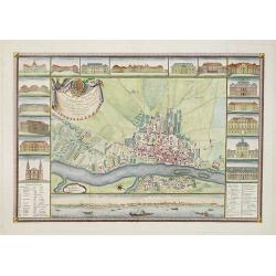
Plan de la ville de Geneve dedié aux très magnifiques très honorès seigneurs. . .
Scarce and beautiful town-plan of Geneva. Two inset plan, in the upper right corner "Plan de Geneva numbered key (1-56) to the important buildings and streets in tow...
Date: Paris, 1773
Selling price: ????
Please login to see price!
Sold in 2012
Chorographie de la Vieille et Nouvelle Castille. . .
The text has been engraved by Herault and the map by Maurille-Antoine Moithey. Embellished with a decorative title cartouche.
Date: Paris, ca. 1773
Selling price: ????
Please login to see price!
Sold in 2015
Chorographie de Royaumes d'Aragon, de Navarre et de la Province de Biscaye. . .
The text has been engraved by Herault and the map by Maurille-Antoine Moithey. Embellished with a decorative title cartouche.
Date: Paris, ca. 1773
Selling price: ????
Please login to see price!
Sold in 2015
Carte d'Espagne. . .
Map of Spain and Portugal engraved by J.E.J. Vallet.
Date: Paris, ca. 1773
Selling price: ????
Please login to see price!
Sold in 2015
Insularum Britannicarum Facies Antiqua
A fine copperplate map of ancient Britain by Christophorus Cellarius in 1773. The Orkney and Shetland islands are shown in an insert at the top left corner. The decorativ...
Date: Leipzig, 1773
Selling price: ????
Please login to see price!
Sold in 2019
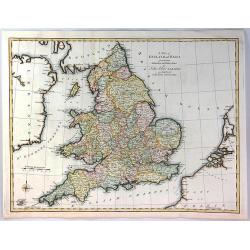
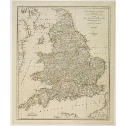
A Map of England and Wales from the Latest Authorities and Observations
A fine map of England and Wales by John Blair L.L.D. & F.R.S. issued as a Supplement to his Tables of Chronology. The Counties of England, and Wales are all separatel...
Date: London, 1773
Selling price: ????
Please login to see price!
Sold in 2018
(Baltic States and Russia)
A copperplate Russian map of the Baltic States and surrounding country of St. Petesburg.Taken from "General Map of the Russian Empire and Maps of Provinces" whi...
Date: Skt. Peterburg, 1761-1773
Selling price: ????
Please login to see price!
Sold in 2017
Sourthen Russia, Ukraine, Belarus, Novo Russia/ Novorossiya.
Copperplate map of southern Russia, Ukraine, Belarus, Novo Russia (aka Novorossiya). Taken from "General Map of the Russian Empire and Maps of Provinces" which ...
Date: St. Petersburg, 1761-1773
Selling price: ????
Please login to see price!
Sold in 2017
RUSSIA, UKRAINE.
Copperplate map of southern eastern european Russia. Taken from "General Map of the Russian Empire and Maps of Provinces" which contained a general map of the E...
Date: St. Petersburg, 1761-1773
Selling price: ????
Please login to see price!
Sold in 2017
!['Finljandskoi' [St.Petersburg Region]](/uploads/cache/98745-250x250.jpg)
'Finljandskoi' [St.Petersburg Region]
A colored copperplate map of St. Petersburg and surrounding country, in Cyrillic . Taken from "General Map of the Russian Empire and Maps of Provinces" which co...
Date: St. Petersburg, 1761-1773
Selling price: ????
Please login to see price!
Sold in 2019
Mappa Geographica Regni Poloniae ex novissimis quot quot sunt mappis. . .
A map of Poland, Lithuania and Belarus, first published in 1750 by Homann Heirs, and now re-issued in 1773. Coastline includes all between Riga and Gdansk. Map is based o...
Date: Nuremberg, 1773
Selling price: ????
Please login to see price!
Sold in 2018
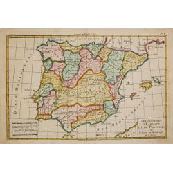
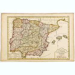
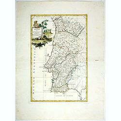
Le Royaume d'Espagne et celui de Portugal.
Rigobert Bonne (1727-1795), French cartographer. His maps are found in a.o. Atlas Moderne (1762), Raynal's Histoire Philos. du Commerce des Indes (1774) and Atlas Encyclo...
Date: Paris, 1774
Selling price: ????
Please login to see price!
Sold
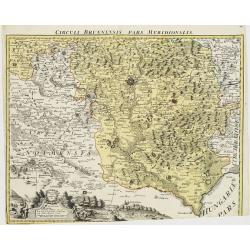
Circuli Brunnensis Pars Meridionalis.
Johann Baptist Homann's well-engraved and detailed map of the present-day South Moravia region centered on Brno, with decorative cartouche at the bottom.Johann Baptist Ho...
Date: Nuremberg 1770 - 1774
Selling price: ????
Please login to see price!
Sold in 2008
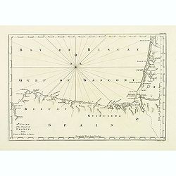
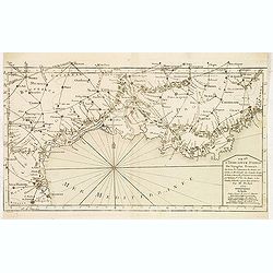
12th Chart of the coast of France from Contis to Bilbao in Spain.
Map of the Gulf of Gascony with Bilbao, st. Sebastian, St. Jean de Luz, Biarritz, Bayonne up to Contis. From his atlas "A Description of the maritime parts of France...
Date: London, 1774
Selling price: ????
Please login to see price!
Sold in 2011
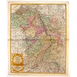
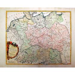
Sedes ac Theatrum Bellorum in Regionibus Rheni, Mosae ac Mosellae.
Striking, highly detailed copper engraved map of the Netherlands, Belgium and parts of Germany. Adorned with a large Rococo style double title and scale cartouche. The Lo...
Date: Augsburg, 1774
Selling price: ????
Please login to see price!
Sold in 2016
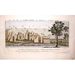
The South View of Easby Abbey near Richmond in York, 1721.
Landscape view of historic castle in Great Britain, original engraved in the early 18th century, and reissued in 1774 as part of a set popularly known as Buck's Antiquiti...
Date: London, 1774
Selling price: ????
Please login to see price!
Sold in 2018
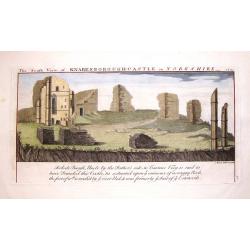
The South View of Knaresborough Castle in Yorkshire, 1721.
Landscape views of historic castles in Great Britain, originally engraved in the early 18th century, and reissued in 1774 as part of Antiquities, a compendium of views of...
Date: London, 1774
Selling price: ????
Please login to see price!
Sold in 2019

The North view of Begeham Abbey, in the County of Sussex.
Landscape view of historic castle in Great Britain, original engraved in the early 18th century, and reissued in 1774 as part of a set popularly known as Buck's Antiquiti...
Date: London, 1774
Selling price: ????
Please login to see price!
Sold in 2017
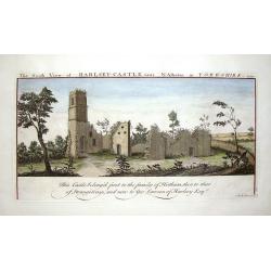
The South View of Harlsey Castle Near N. Allerton in Yorkshire, 1721.
Landscape view of historic castle in Great Britain, original engraved in the early 18th century, and reissued in 1774 as part of a set popularly known as Buck's Antiquiti...
Date: London, 1774
Selling price: ????
Please login to see price!
Sold in 2018
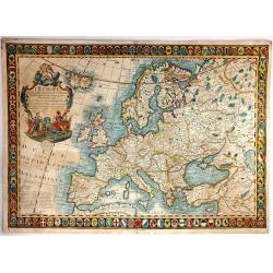
L'Europe Divisee Dans Ses Principaux Etats
A large, striking example of the 1774 edition of the Guillaume Danet, a very decorative map of Europe, surrounded as it is by 110 coats of arms, showing the various state...
Date: Paris, 1774
Selling price: ????
Please login to see price!
Sold in 2016

Special Carte von dem Netz und Warthe Bruche nebst daran gränzenden Landsbergschen gantzen, wie auch einem theile des Friedeberg und Königsbergschen Creises.
A MORE THAN 2 METERS MANUSCRIPT MAP OF WEST-CENTRAL POLANDIn top a large compass rose and south is interestingly oriented to the top. The river Oder is to the utmost righ...
Date: Poland, 1774
Selling price: ????
Please login to see price!
Sold
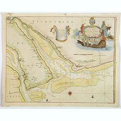
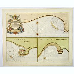
A New and Exact Survey of the River Dee or Chester-Water. . .
An English sea chart by Grenville Collins, depicting (in part) the coastlines and sands of The Wirral, Cheshire, Lancashire and Flintshire, and the River Dee estuary. The...
Date: London, ca 1774
Selling price: ????
Please login to see price!
Sold in 2020
Burlington Bay, Scarborough & Hartlepool.
An impressive sea chart of the north England areas of Hartlepool, Scarborough and Burlington Bay. From Greenville Collins, the Hydrographer to the King (George III), from...
Date: London, ca 1774
Selling price: ????
Please login to see price!
Sold in 2019
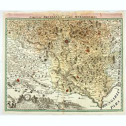
Circuli Brunnensis Pars Meridionalis.
Johann Baptist Homann's well-engraved and detailed map of the present-day South Moravia region centred on Brno, with decorative cartouche at the bottom.Johann Baptist Hom...
Date: Nuremberg 1770 - 1774
Selling price: ????
Please login to see price!
Sold in 2020
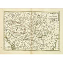
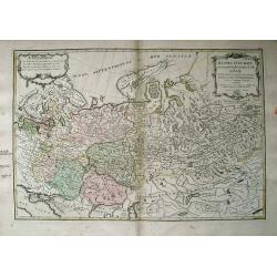
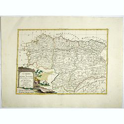
Le Royaume de Hongarie, Divisé en Haute et Basse Hongrie Transilvanie Esclavonie et Croatie. . .
Map of Hungary, part of Poland, Bosnia, Serbia, Bulgaria, prepared by Janvier. From Jean Lattré, "Atlas Moderne ou Collection de Cartes sur Toutes les Parties du Gl...
Date: Paris, 1775
Selling price: ????
Please login to see price!
Sold in 2011
Itinéraire anglois containing the great, direct and cross roads, through England and Wales. . .
Uncommon and detailed map of England and Wales.
Date: London, Sayer and Bennett, 1775
Selling price: ????
Please login to see price!
Sold in 2011
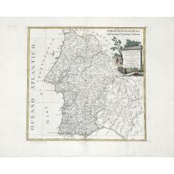
L'Estremadura di Portogallo Alentejo, ed Algarve. . .
Map of the regions of Algarve and Alentejo of Southwestern Portugal by Antonio Zatta. The city of Lisbon is depicted along the western coast, as are the other towns, vill...
Date: Venice, 1775
Selling price: ????
Please login to see price!
Sold in 2010
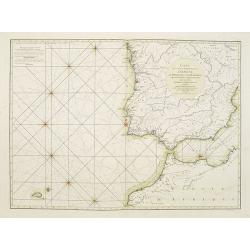
Carte des Côtes occidentales d'Espagne de Portugal et de Barbarie.
Rare French of Spain, Portugal, Gibraltar and part of Morocco. Prepared by Jacques-François L'Abbé Dicquemare (1733-1789). Latitude and longitude scales, compass rose ...
Date: Paris, ca. 1775
Selling price: ????
Please login to see price!
Sold in 2015
Germania Antiqua in Quator Magnos Populus.
A large, detailed, copper engraved map of antique Germany, Poland, and Low Countries that Vaugondy created. It has a large decorative Rococo cartouche. Francois or Paolo ...
Date: Venice, 1775
Selling price: ????
Please login to see price!
Sold in 2015
Russie d'Europe avec la Partie la plus Peuplee de celle d'Asie...
Interesting map covering from Poland and the Baltics, eastward as far as Siberia, with Jenisseisk/Krasnojarsk. Extends to the Black Sea and includes Nouvelle Zembla. Very...
Date: Paris, c1775
Selling price: ????
Please login to see price!
Sold in 2013
Carte du Détroit de Waeigats ou de Nassau.
An interesting map of the Northern passage in Russia.Prepared by Jacques Nicolas Bellin after Dutch sources and included in Prévost d' Exile's "Histoire des Voyages...
Date: Paris, 1738-1775
Selling price: ????
Please login to see price!
Sold in 2014
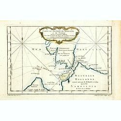
Partie de la Mer Glaciale, contenat le Nouvelle Zemble et le Pais des Samoiedes.
An interesting map of the Nova Zembla and part of the Northeast passage .Prepared by Jacques Nicolas Bellin after Dutch sources and included in Prévost d' Exile's "...
Date: Paris, ca 1775
Selling price: ????
Please login to see price!
Sold in 2014
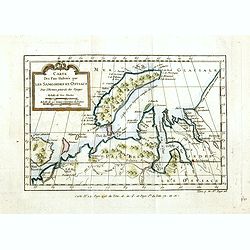
Carte des Païs Habités par les Samojedes et Ostiacs.
An interesting map of the Nova Zembla and the coast of northern Russia .Prepared by Jacques Nicolas Bellin after Dutch sources and included in Prévost d' Exile's "H...
Date: Paris, 1738-1775
Selling price: ????
Please login to see price!
Sold in 2014
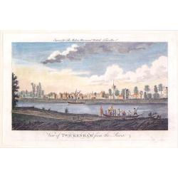
View of Twickenham from the River.
A playful river view of the village of Twickenhan in Middlesex. In th e foreground is the River Thames with two pleasure craft.
Date: London, 1775
Selling price: ????
Please login to see price!
Sold in 2019
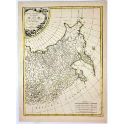
Der südliche Theil Ober-Saechsischen . . .
Kingdom of Prussia, today part of the Polish, Lithuanian and Russian territories.
Date: Augsburg, 1775
Selling price: ????
Please login to see price!
Sold in 2016
Borussiae Occidentalis tabula.
Map covering the region along the Baltic Sea from Prussia to northern Poland after F.L. Güssefeld. Beautiful ornamental title cartouche in upper right.
Date: Nuremberg, ca.1775
Selling price: ????
Please login to see price!
Sold in 2016
Charte von Russisch Litauen, ...
An uncommon map of Belarus, together with parts of the Ukraine and Lithuania. Shows the rivers Dnieper and Dwiner.
Date: Nuremberg, 1775
Selling price: ????
Please login to see price!
Sold in 2017
Regno Di Portogallo.
Map from "Atlas Novissimo" printed in Venice between 1776 and 1785. The map was issued in Zatta's Atlas Novissimo a monumental four volume work and one of the l...
Date: Venise, 1775
Selling price: ????
Please login to see price!
Sold in 2018
![Il Portogallo Cioé le provincie . . . [with] L'Estremadura Di Portogallo alentejo . . .](/uploads/cache/39014-250x250.jpg)
Il Portogallo Cioé le provincie . . . [with] L'Estremadura Di Portogallo alentejo . . .
Two maps of north and South Portugal from "Atlas Novissimo" printed in Venice between 1776 and 1785. The map was issued in Zatta's Atlas Novissimo a monumental ...
Date: Venise, 1775
Selling price: ????
Please login to see price!
Sold in 2017
Andalusia e Granada.
Fine map of Southern Spain with the cities of Seville, Granada and Malaga, including Strait of Gibraltar. Shows administrative boundaries, major cities, villages, rivers ...
Date: Venise, 1775
Selling price: ????
Please login to see price!
Sold in 2017
La Catalogna, li regni di Aragona . . .
Double page map of Catalonia and Aragon from "Atlas Novissimo" printed in Venice between 1776 and 1785. The map was issued in Zatta's Atlas Novissimo a monument...
Date: Venise, 1775
Selling price: ????
Please login to see price!
Sold in 2017
Li Regrni di Galizia, Asturies, Leon, Castiglia Vecchia . . .
Map of The Basque Country in the western Pyrenees that straddles the border between France and Spain on the Atlantic coast. From "Atlas Novissimo" printed in Ve...
Date: Venise, 1775
Selling price: ????
Please login to see price!
Sold in 2017