Browse Listings in Europe
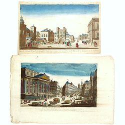
Two opticals of London.
Two optical prints of London, being : "Vue de l'Hotel Royal des Gardes du Corps a pied vis a' vis la Salle Blanche a manger a Londres" and "Vue de L'Hotel ...
Date: Paris c.1780
Selling price: ????
Please login to see price!
Sold in 2016
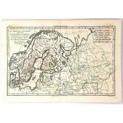
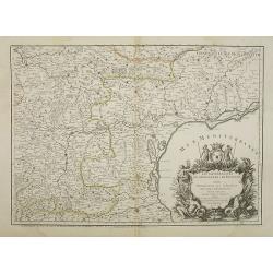
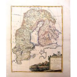
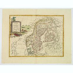
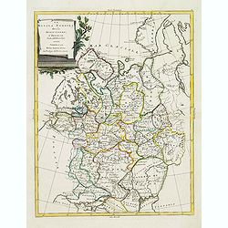
Le Nord de L'Europe...
A fine map of Northern Europe and European Russia. It includes present day Norway, Sweden, Denmark, Finland and parts of Russia, by Rigobert Bonne for G. Raynal’s “AT...
Date: Paris, 1780
Selling price: ????
Please login to see price!
Sold in 2018
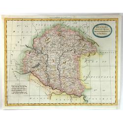
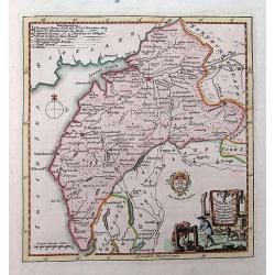
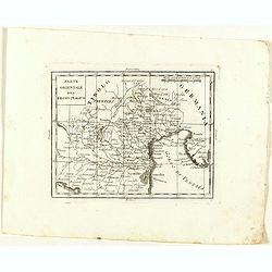
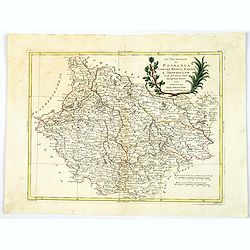
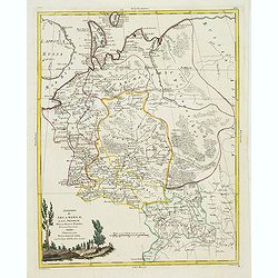
Hungary with Part of the Adjoining Principalities &c.
A fine late 18th century copper engraved map of Hungary and Romania published in 'Barlow's General History of Europe'.Thomas Bowen was an English engraver of charts. He w...
Date: London, 1780
Selling price: ????
Please login to see price!
Sold in 2016
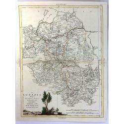
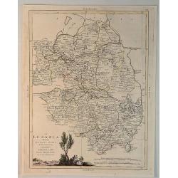
La Lusazia Divisa Nesuoi stati de Nuova Projezione
Lusatia is a historical region between the rivers Bóbr (a tributary of the Oder ) and Kwisa, and the River Elbein Saxony, in Germany, the Eastern Atlantic and Brandenbur...
Date: Venice, 1780
Selling price: ????
Please login to see price!
Sold in 2016
Cumberland drawn from the best surveys,...
An attractive and finely engraved 18th century map of Cumberland. Main cities are shown connected with roads. Borough towns and market towns are indicated, as well as par...
Date: London, ca. 1780
Selling price: ????
Please login to see price!
Sold in 2016
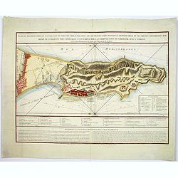
Plan du promontoire de la ville et du port de Gibraltar avec les ouvrages faits depuis le dernier siège. . .
Published in Paris, this attractive map of Gibraltar, on the very tip of the Iberian Peninsula, includes a wealth of information, much of it concerning the Spanish siege ...
Date: Paris, ca 1780
Selling price: ????
Please login to see price!
Sold in 2017
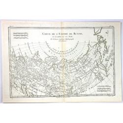
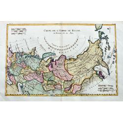
Carte de L'Empire de Russie
An example of Rigobert Bonne and Guillaume Raynal's 1780 map of the Russian Empire. It shows the entire Russian Empire stretching from Europe to the Behring Strait, as we...
Date: Paris, 1780
Selling price: ????
Please login to see price!
Sold in 2017
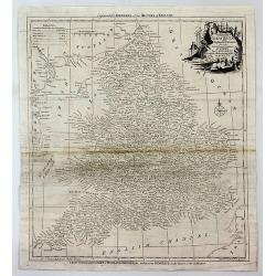
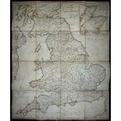
Accurate Map of That District of Great Britain Called England & Wales...
A very detailed map of Great Britain by Thomas Kitchin, from Walpoole's New & Complete British Traveller, published in 1784.The map shows the counties and identifies ...
Date: London, ca. 1780
Selling price: ????
Please login to see price!
Sold in 2017
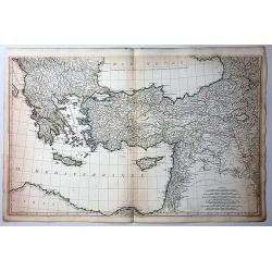
Bottom Part Only of Huge Map centering on Greece.
A large bottom portion of a huge map centering on Greece. The original map was about 41" x 32".This section covers the area between Libya and Iraq on the south ...
Date: Anon, ca. 1780
Selling price: ????
Please login to see price!
Sold in 2017
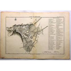
Plan de Bergame.
Bergamo (Bergame) is an Italian town, the capital of the province of the same name, located in Lombardy. It is about 50 km north-east of Milan. This plan by Jerome de la ...
Date: Paris, ca. 1780
Selling price: ????
Please login to see price!
Sold in 2018
Parte Occidentale dell Impero Romano ....
The western part of the Ancient Roman Empire by Anville. It covers the areas of England (Bretagna), Ireland (Hybernia), France (Gallia) and Germania.Jean Baptiste Bourgu...
Date: Paris, ca. 1780
Selling price: ????
Please login to see price!
Sold in 2017

Vue Perspective de la Place des Victoires.
Optical print of Place des Victoires in Paris.
Date: Paris, 1780
Selling price: ????
Please login to see price!
Sold in 2018
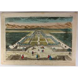
Vue General du Chateau de Monseigneur le Duc de Richelieu en Poitou.
Optical print of Place des Victoires in Paris. Basset was a well-known publisher of optical prints, established in rue St Jacques in Paris. In the 18th century the optica...
Date: Paris, 1780
Selling price: ????
Please login to see price!
Sold in 2018
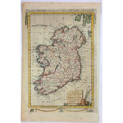
A New and Correct Map of Ireland from the Latest Surveys of That Kingdom.
A fine detailed map of Ireland by John Hamilton Moore in London in 1780. It is from "MOORE'S NEW AND COMPLETE COLLECTION OF VOYAGES AND TRAVELS". Engraved for B...
Date: London, 1780
Selling price: ????
Please login to see price!
Sold in 2019
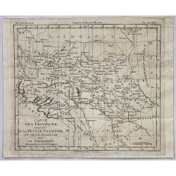
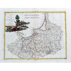
Carte des Provinces Annexees a la Petite Pologne et de la Gallicie avec la Lodomerie Demembrees de la Pologne.
An interesting regional map of Poland and Lithuania, extending from the Karpathian Mountains and Bessarabia to Kiev on the Dniepr, Brescz on the Bug and centered on the p...
Date: Paris, 1780
Selling price: ????
Please login to see price!
Sold in 2018
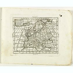
Europa secondo le ultime osservazioni dell' Academia reala delle Scienze.
Rare map of Europe, from "Atlante Novissimo ad uso Dei Giovani Studiosi Contenuto In Carte XXVII.", published by Giovanni Zempel in Rome, ca. 1780.The map is ba...
Date: Rome, 1780
Selling price: ????
Please login to see price!
Sold in 2022
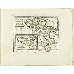
L'Italia Meridionale presa da quella del Sig. Zannomi.
Rare map of Southern part of Italy with inset of Sicily, from "Atlante Novissimo ad uso Dei Giovani Studiosi Contenuto In Carte XXVII.", published by Giovanni Z...
Date: Rome, 1780
Selling price: ????
Please login to see price!
Sold in 2018
Parte Orientale del Regno Italico.
Rare map of north western Italy with Trieste region and Venice and it's bay, from "Atlante Novissimo ad uso Dei Giovani Studiosi Contenuto In Carte XXVII.", pub...
Date: Rome, 1780
Selling price: ????
Please login to see price!
Sold in 2022
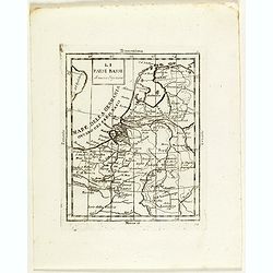
Li Paesi Bassi di Nuova Projezione.
Rare map of the Netherlands, from "Atlante Novissimo ad uso Dei Giovani Studiosi Contenuto In Carte XXVII.", published by Giovanni Zempel in Rome, ca. 1780.The ...
Date: Rome, 1780
Selling price: ????
Please login to see price!
Sold in 2018
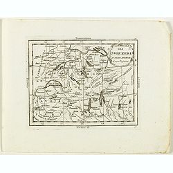
Gli Svizzeri e stati Anessi di nuova Projezione.
Rare map of Switzerland, from "Atlante Novissimo ad uso Dei Giovani Studiosi Contenuto In Carte XXVII.", published by Giovanni Zempel in Rome, ca. 1780.The map ...
Date: Rome, 1780
Selling price: ????
Please login to see price!
Sold in 2018
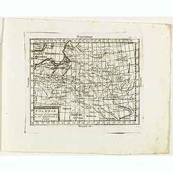
Polonia Secondo le Osservazioni dell' Accademia di Parigi.
Rare map of Poland, from "Atlante Novissimo ad uso Dei Giovani Studiosi Contenuto In Carte XXVII.", published by Giovanni Zempel in Rome, ca. 1780.The map is ba...
Date: Rome, 1780
Selling price: ????
Please login to see price!
Sold in 2019
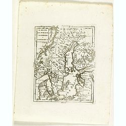
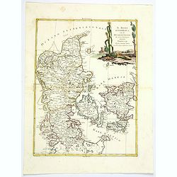
Li regni di svezia Norvegia e Danimarca.
Rare map of Scandinavia, from "Atlante Novissimo ad uso Dei Giovani Studiosi Contenuto In Carte XXVII.", published by Giovanni Zempel in Rome, ca. 1780.The map ...
Date: Rome, 1780
Selling price: ????
Please login to see price!
Sold in 2018
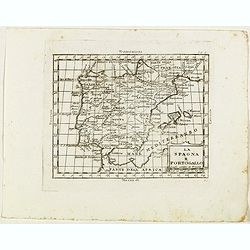
La Spagna e Portogallo.
Rare map of Spain and Portugal, from "Atlante Novissimo ad uso Dei Giovani Studiosi Contenuto In Carte XXVII.", published by Giovanni Zempel in Rome, ca. 1780.T...
Date: Rome, 1780
Selling price: ????
Please login to see price!
Sold in 2019
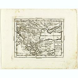
Turchia in Europa . . .
Rare map of Black Sea with Greece and Turkey, from "Atlante Novissimo ad uso Dei Giovani Studiosi Contenuto In Carte XXVII.", published by Giovanni Zempel in Ro...
Date: Rome, 1780
Selling price: ????
Please login to see price!
Sold in 2020
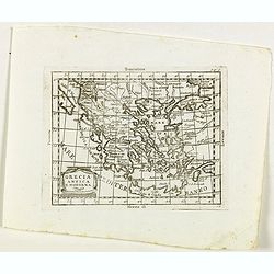
Grecia Antica e Moderna.
Rare map of Greece, from "Atlante Novissimo ad uso Dei Giovani Studiosi Contenuto In Carte XXVII.", published by Giovanni Zempel in Rome, ca. 1780.The map is ba...
Date: Rome, 1780
Selling price: ????
Please login to see price!
Sold in 2020
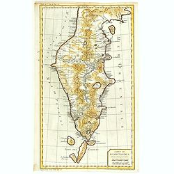
Carte du Kamtchakta Dressée et Gravée par Laurent. . .
An early detailed map of the Kamchatka peninsula, based on the work of Stepan Petrovich Krasheninnikov, who travelled in the area 1737-1741.Drawn and engraved by Laurent ...
Date: Paris, 1757 - 1780
Selling price: ????
Please login to see price!
Sold in 2018
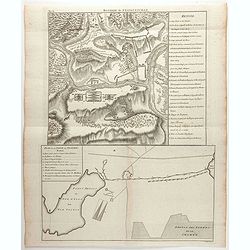
Plan de Gibraltar attaqué par terre et par mer par l'armee espagnole et francaise aux ordres de M. le duc de Crillon, en presence de Mgr le duc d'Artois, d'apres les dessins d'un ingenieur en chef de l'armee. . .
A separately published map of Gibraltar, on the very tip of the Iberian Peninsula, includes a wealth of information about positions of French battle ships concerning the ...
Date: Paris, ca 1780
Selling price: ????
Please login to see price!
Sold in 2018
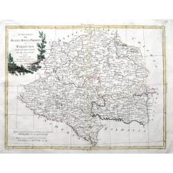
Le Royaume de Pologne, divise en ses duches et Provinces, et subdivise en Palatinats.
This is a fine map of the Kingdom of Poland by Robert de Vaugondy. It depicts the different Palantinates or administrative division of Poland and Lithuania as well as par...
Date: Paris, 1780
Selling price: ????
Please login to see price!
Sold in 2019
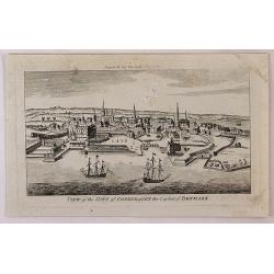
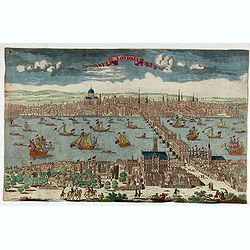
View of the City of Copenhagen, the Capital of Denmark.
A fine panoramic city view map of Copenhagen, Denmark. It features detailed sailing ships in the foreground. From "THE LADY'S MAGAZINE", published monthly in Lo...
Date: London, 1780
Selling price: ????
Please login to see price!
Sold in 2018
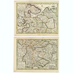
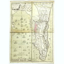
(2 maps) 'T Noorderdeel van Moscovie / T Zuider-Deel van Moscovie.
A nice pair of Russian maps detailing the regions from Moscow south to the Black Sea and the Sea of Azof, and from north of Moscow to the White Sea and Russian Lappland. ...
Date: Deventer, ca 1780
Selling price: ????
Please login to see price!
Sold in 2019

A View of Madrid the Capital of Spain.
A detailed and attractive copperplate perspective view of Madrid, published in London for Middleton's Complete System of Geography. Shows figures in the foreground, pleas...
Date: London, ca 1780
Selling price: ????
Please login to see price!
Sold in 2019
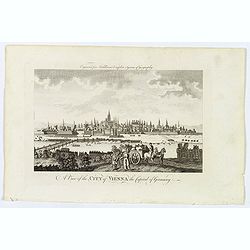
A View of the City of Vienna the Capitol of Germany.
A detailed and attractive copperplate perspective view of the walled city of Vienna, the capitol of the Austro-Hungarian Empire, published in London for Middleton's Compl...
Date: London, ca 1780
Selling price: ????
Please login to see price!
Sold in 2020
Europa veteribus nota. L'Europe Ancienne.
Rarely seen map of ancient Europe. Filled with old names and details. Text panel to the left. With a decorative title cartouche. Engraved by Moithey and Herault.
Date: Paris, ca. 1780
Selling price: ????
Please login to see price!
Sold in 2019
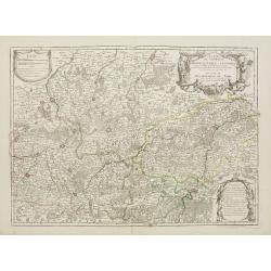
Il Circolo della Bassa Sassonia divisio ne Suoi Stati. . .
An attractive map of Lower Saxony by Antonio Zatta, from the Atlante Novissimo atlas. The map is engraved with great care and skill, and is embellished with a lovely larg...
Date: Venice, 1780
Selling price: ????
Please login to see price!
Sold in 2021
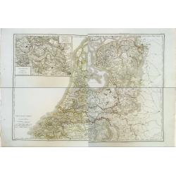
Province-Unies en 4 Feuilles.
Rare wall map sized map in 4 sheets of the Netherlands, with inset map of a large part of Zeeland. Finely engraved and highly detailed and complete map on thick paper. Ve...
Date: Paris, 1780
Selling price: ????
Please login to see price!
Sold in 2020

Vue Perspective de L'Entrée du Parc du Prince de Manheim en Allemagne.
A perspective view of the Royal Park in Manheim by Basset, a well-known publisher of optical prints, established in rue St.Jacques in Paris. In the eighteenth and ninetee...
Date: Paris, 1780
Selling price: ????
Please login to see price!
Sold in 2023
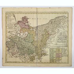
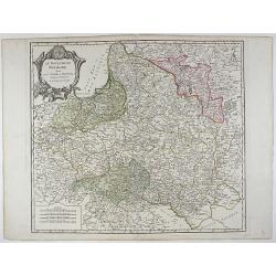
Der nordliche Theil des Obersachsischen Kreises oder die Mark Brandenburg und das Herzogthum Pommern.
A detailed map of the upper Saxon circle with Brandenbourg, Pommern, in Germany. Complete with a table of notes and explanations, and a scroll cartouche containing the me...
Date: Nuremberg, ca 1780
Selling price: ????
Please login to see price!
Sold in 2021
La Lusanzia Divisa Nesuoi Stati di Nouva Projezione.
A fine detailed map of Lustia, Poland and Germany by Zatta in 1790. It features a pleasing hand-colored cartouche.Antonio Zatta (1775-1797) was the most prominent Italian...
Date: Venice, 1780
Selling price: ????
Please login to see price!
Sold in 2020
Carte de l'empire de Russie en Europe et en Asie.
An interesting 18th century map of Russia, from the Black Sea until Alaska. Shows major towns, regions, rivers, and mountains. Also curious islands in the northern Pacifi...
Date: Paris, ca. 1780
Selling price: ????
Please login to see price!
Sold in 2020
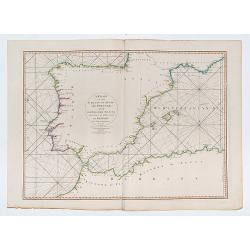
A Chart of the Coasts of Spain and Portugal, with the Balearic Islands, and Part of the Coast of Barbary.
Double page chart of the seas surrounding Spain and Portugal.
Date: London, 1780
Selling price: ????
Please login to see price!
Sold in 2023

Vue Perspective du Palais du Duc d'Aveiro a Lisbonne.
Perspective view of the Palace of the Duke of Aveiro in Lisbon. A well-known publisher of optical prints, established in rue St.Martin in Paris.In the eighteenth and nine...
Date: Paris, 1780
Selling price: ????
Please login to see price!
Sold in 2021
Bataille de Stavoutschan
Shows the battle of Stavutschan during the Russo-Austrian Turkish War (1736-39). Right legend of A-V. Taken from Chr. H. v. Manstein, "Mémoires historiques, polit...
Date: Paris, c.1780
Selling price: ????
Please login to see price!
Sold in 2020
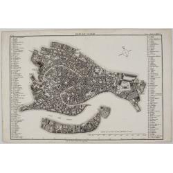
Plan de Venise.
A rare and extremely detailed plan of the city of Venice, Italy. Plazas, streets, fountains, public places, antiquities, schools and notable palaces are all identified by...
Date: Paris, 1780
Selling price: ????
Please login to see price!
Sold in 2020
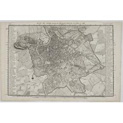
Plan de Rome. . .
A rare and extremely detailed plan of the city of Rome, Italy. This map is a reduced version of J. B. Nolli’s famous 1748, 12 sheet map of Rome. It includes; Plazas, st...
Date: Paris, 1780
Selling price: ????
Please login to see price!
Sold in 2020
Das Herzogthum Ober und Nieder Baiern in seine Aemter oder Gerichter eingetheilt, nebst allen darinn liegenden und angrænzenden Lændern / Neu in 4 Blatt herausgegeben von Gebrüder Lotter in Augsburg
Folding map of The Duchy of Upper and Lower Bavaria. Including Regensburg, München, Salzburg in Austria. In very attractive colors.More about folding maps. [+]
Date: Augsburg, 1780
Selling price: ????
Please login to see price!
Sold in 2021
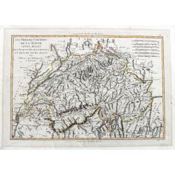
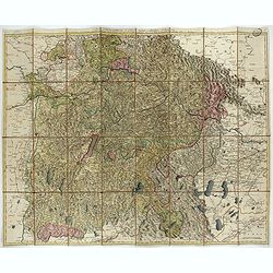
Les Treize Cantons de la Suisse, leurs allies, les sujets de ces Cantons; et ceux de leurs allies.
Attractive map with decorative coloring. Published in an atlas by Rigobert Bonne, engraved by André. Shows Switzerland and its bordering areas. Including parts of north...
Date: Paris, 1780
Selling price: ????
Please login to see price!
Sold in 2021
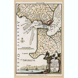
A Plan of the City of Lisbon with the Harbour, Forts, Depths of Water and Country adjacent.
A lovely small plan of the city and immediate surrounds of the Portuguese capitol, complete with a mileage scale, compass rose and a decorative title vignette in the lowe...
Date: London, ca 1780
Selling price: ????
Please login to see price!
Sold in 2021
Londres.
Decorative print of London.
Date: Paris, ca. 1780
Selling price: ????
Please login to see price!
Sold in 2022
![[Map of Switzerland Lucerne canton.]](/uploads/cache/47454-250x250.jpg)
[Map of Switzerland Lucerne canton.]
Map sheet from a multi-sheet map of Switzerland. In the center Sempacher See and Lucerne.
Date: Germany, ca. 1780
Selling price: ????
Please login to see price!
Sold in 2025
BELGIUM.
Map of the southern part of Belgium and the northern part of France. Brussels in the north, Mons in the south, Huy in the east and Tournay/Douai in the west.
Date: Paris 1781
Selling price: ????
Please login to see price!
Sold
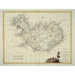
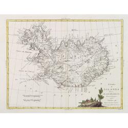
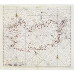
L'Isola d'Icelanda Divisa Ne Suoi Distretti Di nuova Projezione
A very attractive map of Iceland, with a decorative title cartouche to the bottom right hand corner depicting a walled village amongst trees.
Date: Venice, 1781
Selling price: ????
Please login to see price!
Sold
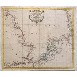
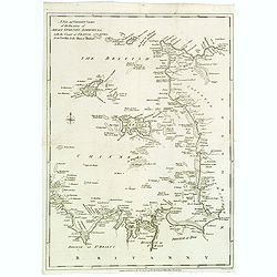
A Chart of the Northern Ocean between the coasts of England and the United Provinces belonging tot the States General
Printed for R. Baldwin at the Rose Pater Noster Row. From London Magazine January 1781. Map of the Noth Sea or Northern Ocean with the coasts of Dorset, Hampshire, Succes...
Date: London, 1781
Selling price: ????
Please login to see price!
Sold in 2013
Les Généralitez de Montauban et de Toulouse . . .
Detailed map of the southwest of France, including the towns of Carcassonne, Perpignan, including the Royal Canal.Avec Privilège du Roy.
Date: Paris, 1781
Selling price: ????
Please login to see price!
Sold
L'Isola d'Icelanda Divisa Ne Suoi Distretti Di nuova Projezione.
A very attractive map of Iceland, with a decorative title cartouche to the bottom right hand corner depicting a walled village amongst trees. Published in Zatta's "A...
Date: Venice, 1781
Selling price: ????
Please login to see price!
Sold in 2017
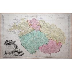
Carte des Etats de Boheme . . .
Louis Brion de la Tour map of Bohemia (Czech Republic), city of Prague is in the center of the map.
Date: Paris, 1781
Selling price: ????
Please login to see price!
Sold in 2010
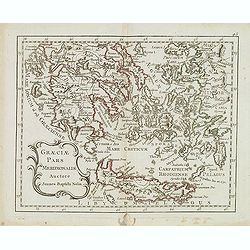
Graeciae pars meridionalis auctore. . .
Rare map of Greece and the most western coastline of Turkey, prepared by Nolin and published by L.J. Mondhare for his Atlas Général a l'usage des colleges et maisons d'...
Date: Paris, 1781
Selling price: ????
Please login to see price!
Sold in 2017
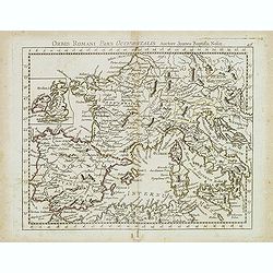
Orbis Romani Pars Ocidentalis. . .
Map of the ancient Roman Empire, prepared by Nolin and published by L.J. Mondhare for his Atlas Général a l'usage des colleges et maisons d'education.. Louis Joseph Mon...
Date: Paris, 1781
Selling price: ????
Please login to see price!
Sold in 2023
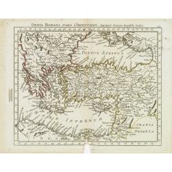
Orbis Romani Pars Orientalis. . .
Unusual map of Ancient Turkey, including a curiously shaped Cyprus, prepared by Nolin and published by L.J. Mondhare for his Atlas Général a l'usage des colleges et mai...
Date: Paris, 1781
Selling price: ????
Please login to see price!
Sold in 2023
La Svezia Divisa Ne\' Suoi Regni di Nuuva Projezione
A lovely decorative map of Sweden, Finland and Laponia (Lapland). It has a pleasing, scenic title cartouche. Zatta (1775-1797) was the most prominent Italian map publish...
Date: Vienna, 1781
Selling price: ????
Please login to see price!
Sold in 2013

Charles II Concealed in the Oak.
Interesting hand-colored copper engraving from "RUSSELL'S HISTORY OF ENGLAND" in 1781. It was engraved by White after a picture by Wade.
Date: London, 1781
Selling price: ????
Please login to see price!
Sold in 2016
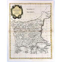
Le Provincie di Bulgaria, e Rumelia Tratte dalla carte dell' Impero Ottomano del Sig Rizzi Zanoni
A copper engraving, in delightful original outline color, featuring both Bulgaria & Romania. A decorative map by the northern Italian cartographer; Antonio Zatta, and...
Date: Venice, 1781
Selling price: ????
Please login to see price!
Sold in 2018
Parte Orientale Dell Elvezia Divisa Ne' Suoi Cantoni.
Parte Orientale Dell Elvezia Divisa Ne' Suoi Cantoni. Eastern Switzerland from Lake Constance (Bodensee) south to Lago Maggiore and Lago di Lugano. Cantons shown: Schaffh...
Date: Venice, 1781
Selling price: ????
Please login to see price!
Sold in 2016
The Roads of Great Britain. Itineraire de la Grande Bretagne. Published as the Act directs Jan 1st 1781 By William Faden Succr to the late T Jefferys Geographer to the King, Charing Cross
A rare example of Faden's desirable folding map 'Roads of Great Britain' in its first edition of 1781.Covering from Scotland to Cornwall, this large pocket map was design...
Date: London, 1781
Selling price: ????
Please login to see price!
Sold in 2017
A New and Correct Chart of the Islands of Jersey, Guernsey, Alderney...
A detailed map of the Channel Islands, and sections of Brittany and Normandy, from the Neville to the Isles of Brehat. Included in the Political Magazine , engraved by Lo...
Date: London 1781
Selling price: ????
Please login to see price!
Sold in 2016
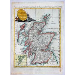
A New and Correct Map of SCOTLAND, Drawn from the Latest Surveys of that Party of Great Britain.
A fine copperplate map from “Barnard's New Complete and Authentic History of England”, published in London by Edward Barnard in 1781-1783.It features a marine cartouc...
Date: London, 1781
Selling price: ????
Please login to see price!
Sold in 2019
Li Regni di Svezia, Danimarca e Norvegia. . .
Antonio Zatta's detailed map of Sweden, Denmark, Norway and Finland, embellished with a delicately colored title cartouche depicting fishermen hauling in their nets. Show...
Date: Venice, 1781
Selling price: ????
Please login to see price!
Sold in 2019
Il Regno di Danimarca con il Ducato di Sleswik. . .
A delicate and finely engraved map of Denmark by Antonio Zatta, published in Venice towards the end of the eighteenth century. The map is enhanced by a delightful title c...
Date: Venice, 1781
Selling price: ????
Please login to see price!
Sold in 2019
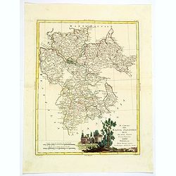
Li Palatinati di Posnania Gniesno, Brzesc, Kalisz e Inowroclaw. . .
An attractive and detailed map of part of Western part of Poland centered on Poznan. The decorative and large pictorial title cartouche is fully colored. Published in Zat...
Date: Venice, 1781
Selling price: ????
Please login to see price!
Sold in 2019
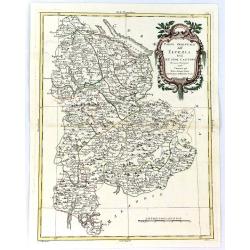
Li Palatinati della Russia Rossa Podolia e Wolhynia Tratta dall' Atlante Polaco del Sigr. Rizzi Zanoni.
A very detailed map of the Western Ukraine and a small part of Poland. With the the Voivodeships of Ruthenia, Podole and Volhynia. It includes Ternopil, Lviv, Lublin, Luz...
Date: Venice, ca 1781
Selling price: ????
Please login to see price!
Sold in 2019
Il Regno die Pussia con la Prussia Polacca...
Italian copper engraved map of parts of Poland including Danzig (Gdansk), the Russian enclave of Kaliningrad, the Baltic Sea with the Lithuanian coasts. With many place n...
Date: Venice, 1781
Selling price: ????
Please login to see price!
Sold in 2020
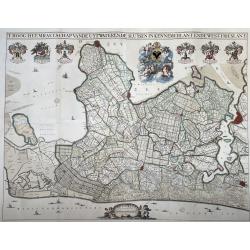
T Hoogh-Heemraetschap van de Uytwaterende Sluysen in Kennemerlant ende West-Frieslant’
A very large format wall map of the province of North Holland made and published for the district water board of Kennemerland and West Friesland, on four leaves, combined...
Date: Amsterdam, 1781
Selling price: ????
Please login to see price!
Sold in 2021
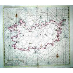
Nieuwe en seer Accurate Paskaart van het Eyland Yslandt In het Groot
Printed in 1782, a scarce original chart of Iceland published by the renowned Amsterdam map and chart publishing dynasty founded by Johannes van Keulen. This chart replac...
Date: Amesterdam (1750) 1782
Selling price: ????
Please login to see price!
Sold
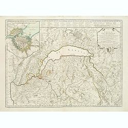
Carte du lac de Genève et des pays circonvoisins..
Map centered on Lake Geneva. In upper left corner inset map of Geneva.Complete title: Carte du lac de Geneve et des pays circonvoisins où se trouvent les frontieres de F...
Date: Paris, 1782
Selling price: ????
Please login to see price!
Sold
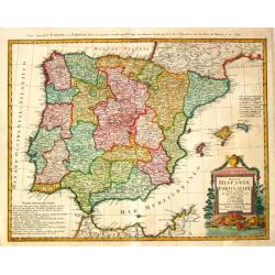
Regnorum Hispaniae et Portugalliae Tabula generalis.
Homann Heirs (of Johann Baptist and Johann Christof) published: Grosser Atlas, 1731, 1737. Geogr. Maior, 1759, Atlas Homannianus, 1762.Lopez?s map of the Iberian peninsul...
Date: Nurnberg, 1782
Selling price: ????
Please login to see price!
Sold
Nieuwe en seer Accurate Paskaart van het Eyland Yslandt In het Groot..
Printed in 1782, a scarce original chart of Iceland published by the renowned Amsterdam map and chart publishing dynasty founded by Johannes van Keulen. This chart replac...
Date: Amesterdam (1750) 1782
Selling price: ????
Please login to see price!
Sold in 2009
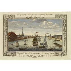
A perspective view of Petersburg, the capital of Russia.
Fine decorative view of St. Petersburg, made for George H. Millar's New and Universal system of Geography , published by Thornton.
Date: London, 1782
Selling price: ????
Please login to see price!
Sold in 2011
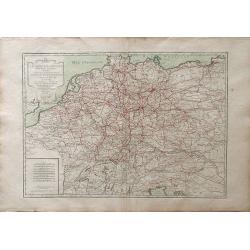
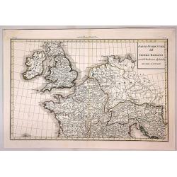
L\'Empire d\'Allemagne divise en fes principaux Etats, ou font exactement remarquees Toutes Les Routes des Postes et Chariots de Poste de L\'Empire
A fine map of the German empire of north and central Europe, showing the areas of northwestern France, Belgium, Netherlands, northern Italy, Switzerland, Luxembourg, Aust...
Date: Paris, 1782
Selling price: ????
Please login to see price!
Sold in 2010
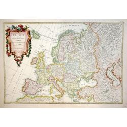
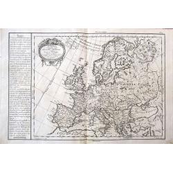
L'Europe divisée en ses principaux Etats.
A beautiful example of Jean Janvier's decorative map of the Europe. Covers from Iceland to the Caspian Sea and from North Africa to the Arctic. Divided into countries and...
Date: Paris, 1782
Selling price: ????
Please login to see price!
Sold in 2012
Governo di Arcangelo, e sue Provincie Nella Russia Europea . . .
Map shows the island Nova Zembla and the government of Archangel, Jarensk and Chlynow. Engraved by G. Zuliani and G. Pitteri.Published in Zatta's 'Atlante Novissimo'. Dec...
Date: Venice, 1782
Selling price: ????
Please login to see price!
Sold in 2012
La Russia Europa divisa Ne'suoi Governi e Provincie . . .
An attractive and detailed map of Western Russia with Lapland. Decorative and large pictorial cartouche is fully colored.Published in Zatta's' Atlante Novissimo'. Engrave...
Date: Venice, 1782
Selling price: ????
Please login to see price!
Sold in 2012