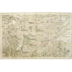
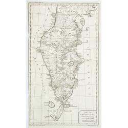
Browse Listings in Europe
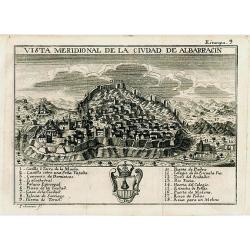
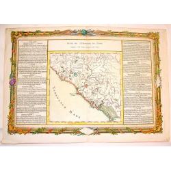
Vista meridional de la ciudad de Albarracin
Scarce and very decorative city view published in "ATLANTE ESPAÑOL - Don Bernardo Espinalt y Garcia" engraved by Palomino, showing Albarracin in Teruel, Aragon...
Date: Madrid, 1779
Selling price: ????
Please login to see price!
Sold in 2008
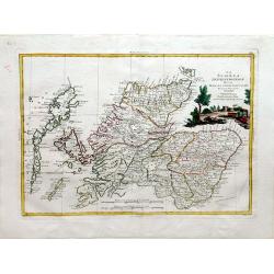
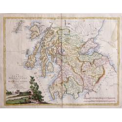
La Scozia Settentrionale Divisa Nelle Sue Contee Particolari
This is a top half of a two sheet map of Scotland showing northern Scotland by Antonio Zatta, engraved by Pitteri. Shows regions of Strathnavern, Ross-shire, Inverness, M...
Date: Venice, 1779
Selling price: ????
Please login to see price!
Sold in 2010
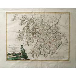
La Scozia Meridionale divisa Nelle sue Contee Particolari di Nuova Projezione.
A detailed map of regions in Scotland by Antonio Zatta. Depicts major cities such as Carrick, Galloway, and Perth, and major river systems in the area. This map also show...
Date: Venice, 1779
Selling price: ????
Please login to see price!
Sold in 2010
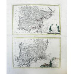
Provincia di Essex di nuova Projezione / Provincia di Middlesex di nuova Projezione. . .
Maps of Essex county (top) and Middlesex county (bottom), a former county, both located in the Southeast Greater London region by Antonio Zatta. The cities of Kingston an...
Date: Venice, 1779
Selling price: ????
Please login to see price!
Sold in 2010
La Scoza Meridionale Divisa Nelle Sue Contee Particolari Di Nuova Projezionev Venezia 1779 Autonio Zatta
Attractive map of Southern Scotland by Antonio Zatta engraved by Giovanni Marco Pitteri one of Italy’s greatest engravers.A copper engraving with beautiful hand colorin...
Date: Venice, 1779
Selling price: ????
Please login to see price!
Sold in 2018

Carte des provinces-unies connue sous le nom d'Hollande dressée sur les nouvelles observations ordonnée par les etats généraux par J. B. de la Fosse. . . 1779
Rare map of the Netherlands prepared by Jean-Baptiste Delafosse. North Sea is filled with ships. Louis Joseph Mondhare was active in Paris and published several smaller a...
Date: Paris, 1779
Selling price: ????
Please login to see price!
Sold in 2012
![A map of the Kingdom of Ireland showing the archbishopricks, bishopricks, cities, boroughs, market towns, villages, barracks, mountains [. . .] by J. Rocque, chorographer to His Majesty.](/uploads/cache/92786-250x250.jpg)
A map of the Kingdom of Ireland showing the archbishopricks, bishopricks, cities, boroughs, market towns, villages, barracks, mountains [. . .] by J. Rocque, chorographer to His Majesty.
A dramatic large four sheet map, (here on two joined sheets) from Sayer's large Atlas of 1779.Rocque was Topographer to the Prince of Wales and attained his new title aft...
Date: London, 1779
Selling price: ????
Please login to see price!
Sold in 2015
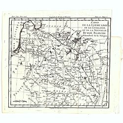
Carte de la Lithuanie, de la Courlande, et de la nouvelle Russie Blanche démembrée de la Pologne.
A map of the Lithuania territories of Louis Brion de la Tour, from the work "Histoire universelle depuis le commencement du monde jusqu a present" published in ...
Date: Paris, 1779
Selling price: ????
Please login to see price!
Sold in 2019
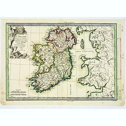
L'Irlande. . .
An attractive map of Ireland, prepared by M. Philippe, embellished with a decorative title cartouche. Drawn and engraved by Vallet and Moithey. With a scale of miles, and...
Date: Paris, 1779
Selling price: ????
Please login to see price!
Sold in 2018
Le Voyageur François, ou la Connoissance de l'Ancien et du Nouveau Monde. Tome XXII.
With folding map of Poland (180 x 220mm.)
Date: Paris, L.Cellot, 1779
Selling price: ????
Please login to see price!
Sold in 2019
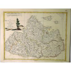
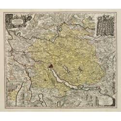
La Moravia Divisa Ne Suoi Circoli. . .
A handsome map of Moravia that is part of the present-day Czech Republic. The map is focused roughly on Wischau and is filled with details of roads, towns and pictorial t...
Date: Venice, 1779
Selling price: ????
Please login to see price!
Sold in 2021
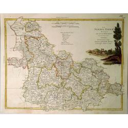
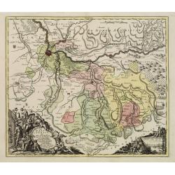
La Slesia InferE Divisa ne Principati di Nuova Projezione.
A handsome map of South Western Poland divided into its provinces. Filled with details of roads, towns and pictorial topography, and features a lovely pastoral title cart...
Date: Venice, 1779
Selling price: ????
Please login to see price!
Sold in 2020
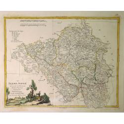
La Slesia Super Divisa ne Suoi Principati di Nuova Projezione.
A striking map of Upper Silesia divided into its principalities. This is now South-Eastern Poland. Features pleasing topographical title cartouche. Antonio Zatta (1757–...
Date: Venice, 1779
Selling price: ????
Please login to see price!
Sold in 2019
L'Angleterre... par Mr. Philippe. . .
An unusual copper engraved map of England, also showing parts of Ireland. Filled with places names in England. Decorative title cartouche. With a curious climatalogical s...
Date: Paris, 1779
Selling price: ????
Please login to see price!
Sold in 2020
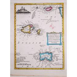
Antique map of the Channel Islands.
A nice antique map of the Channel Islands, published in the English Gentleman's Magazine. Inset at top left of Cornet Castle. Mileage scale.
Date: London, 1779
Selling price: ????
Please login to see price!
Sold in 2020
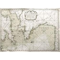
Carte de la Manche des costes de France parties de celle d'Espagne jusqu'au Cap Orgetal.
A very rare sea-chart of the Channel between England and France, including the Bay of Biscay with the coasts of northern Spain, and even a small tip of Ireland. A very ap...
Date: Bordeaux, 1779
Selling price: ????
Please login to see price!
Sold in 2021
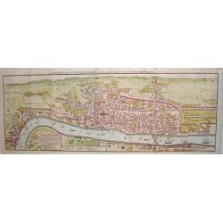
London and Westminster in the Reign of Queen Elizabeth Anno Dom 1563.
A rare 18th century pull out town plan of London, as it was known during the time of Elizabeth I. This work is very much patterned after the famous first large scale plan...
Date: London, 1780
Selling price: ????
Please login to see price!
Sold

A general view of the city of Amsterdam from the Ye.
"A so-called optical print. In the eighteenth and nineteenth centuries there were many popular speciality establishments in Paris, Augsburg and London, which produce...
Date: London 1780
Selling price: ????
Please login to see price!
Sold
Pagi Basileensis qui pars est reipublicae Helvetiorum..
Detailed map of Basle Canton, centered on Basel and Rheinfelden.With fine title cartouche with panoramic view of Basel and heraldic figures like Neptune's, Mercury, Justi...
Date: Augsburg 1780
Selling price: ????
Please login to see price!
Sold in 2013
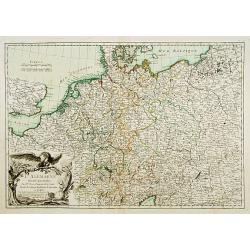
L'Alemagne divisée... / Carte de l'Empire d'Alemagne?
2 decorative maps of Germany with nice title cartouches.
Date: Paris c.1780
Selling price: ????
Please login to see price!
Sold
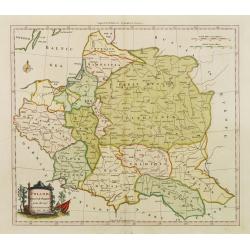
(Map of Poland and Prussia.)
Map centered on the Baltic depicting Prussia and North Poland.
Date: Paris c.1780
Selling price: ????
Please login to see price!
Sold
Theatrum Historicum.. Romani tu Barbarorum.. Pars Occidentalis..
Showing the Roman Empire by G. de l'Isle, French cartographer, pupil of Cassini, called Father of Modern Geography. In upper left hand corner the Western hemisphere. Engr...
Date: Paris, 1780
Selling price: ????
Please login to see price!
Sold in 2008
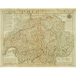
Carte de Suisse ou sont les Cantos de ..
General map of Switzerland with all the cantons good detail. In upper part 24 coats of arms of the different cantons.
Date: Paris, 1780
Selling price: ????
Please login to see price!
Sold in 2014
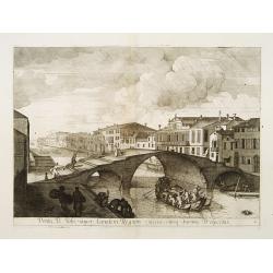
Pontis D. Jobi super Canalem Regium extensi eiusq vicinic Prospectus.
Decorative and dramatic engraved print of a bridge in Venice. Published by Domenico Lovisa (c.1690-c.1750), and engraved by Sipion Feramosca.
Date: Venice 1780
Selling price: ????
Please login to see price!
Sold

Cour des Lions dans le Palais..a Granada.
In the eighteenth and nineteenth centuries there were many popular speciality establishments in Paris, Augsburg and London which produced optical viewing devices and spec...
Date: Italy / France 1780
Selling price: ????
Please login to see price!
Sold
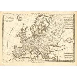
L' Europe
Rigobert Bonne (1727-1795), French cartographer. His maps are found in a.o. Atlas Moderne (1762), Raynal's Histoire Philos. du Commerce des Indes (1774) and Atlas Encyclo...
Date: Paris, c. 1780
Selling price: ????
Please login to see price!
Sold
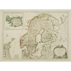
Les Royaumes de Suede et Norwege divisés par Provinces..
Detailed map of Scandinavia, with inset of Iceland. The author is M. Janvier.
Date: Venise, ca. 1780
Selling price: ????
Please login to see price!
Sold
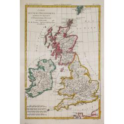
Carte des Isles Britanniques.
Rigobert Bonne (1727-1795), French cartographer. His maps are found in a.o. Atlas Moderne (1762), Raynal's Histoire Philos. du Commerce des Indes (1774) and Atlas Encyclo...
Date: Paris, c. 1780
Selling price: ????
Please login to see price!
Sold in 2018
Le Nord de l'Europe.
Rigobert Bonne (1727-1795), French cartographer. His maps are found in a.o. Atlas Moderne (1762), Raynal's Histoire Philos. du Commerce des Indes (1774) and Atlas Encyclo...
Date: Paris, c. 1780
Selling price: ????
Please login to see price!
Sold in 2009
Poland Corrected & Improve'd from the best authorities..
Uncommon map of Poland, prepared by John Barber, and engraved for and published in William Guthrie's new Geographical Grammer.With typical 18th century title cartouche lo...
Date: London 1780
Selling price: ????
Please login to see price!
Sold
Delineatio Pagi Tigurini ex observationibus recentissimis et accuratissimis : accedit seorsim in tabella dominum Sax et Forsteck.
Detailed map centered on Zurich. With very fine cartouches, upper right 36 coats of arms of cities in the region.Engraved by Tobias C. Lotter.
Date: Augsburg 1780
Selling price: ????
Please login to see price!
Sold in 2023
Pagi Basileensis qui pars est reipublicae Helvetiorum..
Detailed map of Basle Canton, centred on Basel and Rheinfelden.With fine title cartouche with panoramic view of Basel and heraldic figures like Neptune's, Mercury, Justit...
Date: Augsburg, 1780
Selling price: ????
Please login to see price!
Sold in 2022

J.Anckerstöm a killer of King Gustave III.
Decorative aquatint engraving after Witterquits.
Date: Augsburg 1780
Selling price: ????
Please login to see price!
Sold
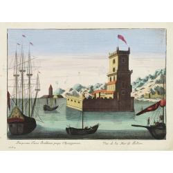
Prospectus Turris Bethlemi prope Ulyssipponem - Vue de la Tour de Bellem.
Optical view of the Belém Tower located in the Belém district of Lisbon, Portugal.In the eighteenth and nineteenth centuries there were many popular speciality establis...
Date: Italy 1780
Selling price: ????
Please login to see price!
Sold
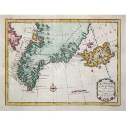
Groenland.
Date: Amsterdam, 1780
Selling price: ????
Please login to see price!
Sold
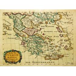
Carte de la Grece dressée sur un grand nombre de memoires..
Detailed copper-engraved map of Greece with its neighboring countries, including southern Italy and part of Cyprus. Relief shown pictorially. With large decorative title ...
Date: Paris, 1780
Selling price: ????
Please login to see price!
Sold in 2009
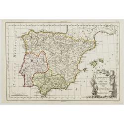
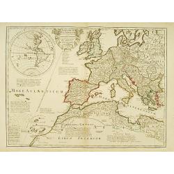
Imperii Romani Pars Occidentalis. Hispania. L'Espagne..
Detailed map of the Hibernian Peninsula and Baleares islands, showing also southwestern part of France.Decorative title cartouche in the lower right corner.
Date: Paris, ca 1780
Selling price: ????
Please login to see price!
Sold
Partie de Turquie en Europe.
Nicolas Sanson (1600-67), ' father of the French cartography' and founder of the Sanson firm. Atlas ' Cartes générales de toutes les parties du Monde', 1658-70 and a po...
Date: Paris, c. 1780
Selling price: ????
Please login to see price!
Sold
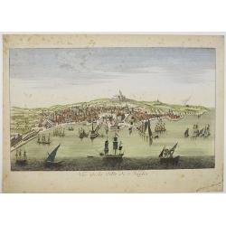
![VUE DE MALTE. [View of Malta -Valetta].](/uploads/cache/24719-250x250.jpg)
VUE DE MALTE. [View of Malta -Valetta].
A so-called optical print. A very decorative and extremely rare view of Valetta, seen from the sea. The mirror-image title in top reads :Vue de la partie sud est de la vi...
Date: Paris, 1780
Selling price: ????
Please login to see price!
Sold in 2008
Vue de Malte.
Uncommon optical print of the harbour viewof Valletta on Malta. Text in French. Basset was a well-known publisher of optical prints, established in Paris, rue St.Jacques....
Date: Paris, 1780
Selling price: ????
Please login to see price!
Sold in 2013
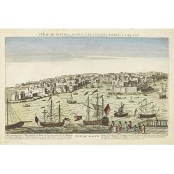
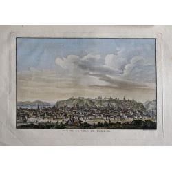
Vue de la ville de Naples.
A so-called optical print showing a panoramic view of Naples with a busy harbour.More about optical prints.
Date: Paris, c. 1780
Selling price: ????
Please login to see price!
Sold in 2016
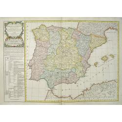
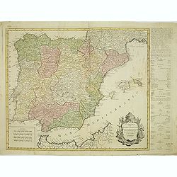
Carte des Royaumes d' Espagne et de Portugal divisés par . . .
A detailed map of Spain and Portugal. Embellished with an attractive title-cartouche. Published by Charles François Delamarche (1740-1817), a Paris-based geographer and ...
Date: Paris, 1780
Selling price: ????
Please login to see price!
Sold in 2016
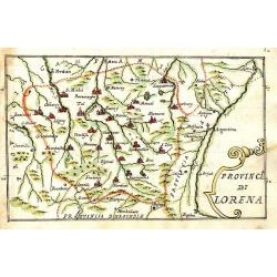
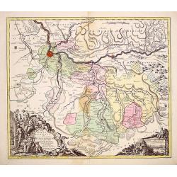
Provincia di Lorena.
Scarce manuscript map of the Lorraine region. Includes the cities of Metz, Verdun, Nancy,... Finely executed and detailed map by an Italian hand, showing the cities repre...
Date: 1740-1780
Selling price: ????
Please login to see price!
Sold in 2009
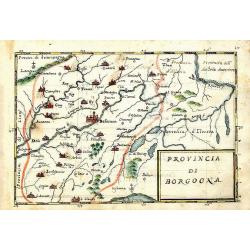
Provincia di Borgogna.
Rare manuscript map of the French border to Switzerland. Centered on Besancon, including the Lake de Geneva in Switzerland. Finely executed and detailed map by an Italia...
Date: c. 1740-1780
Selling price: ????
Please login to see price!
Sold in 2013
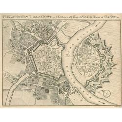
Plan of Dresden, Capital of Saxony.
Small plan of Dresden.
Date: 1780
Selling price: ????
Please login to see price!
Sold in 2010
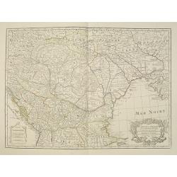
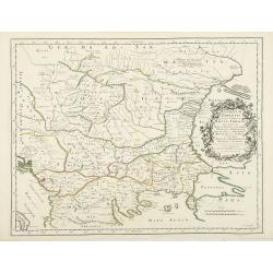
Carte de la Hongrie et Partie Septentrionale de la Turquie. . .
Showing the region between the Gulf of Venice and Croatia to the Black Sea, including Bulgaria, Romania, Macedonia, Ukraine, Hungary, and part of Poland and Bohemia.Decor...
Date: Paris, 1780
Selling price: ????
Please login to see price!
Sold in 2023
Montlouis.
Montlouis (Languedoc-Roussillon).
Date: Paris, ca. 1780
Selling price: ????
Please login to see price!
Sold in 2011
Carte du Kamtchakta. . .
An early detailed map of the Kamchatka peninsula, based on the work of Stepan Petrovich Krasheninnikov, who travelled in the area 1737-41.Drawn and engraved by Laurent fo...
Date: Paris, 1780
Selling price: ????
Please login to see price!
Sold in 2010
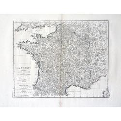
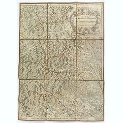
La France Divisee en Provinces et en Generalites Dont le plan est selui de l'ancienne Gaule. . .
A beautiful, large scale, highly detailed, 18th century map of France modeled on a plan of ancient Gaul by Jean Baptiste Bourguignon D'Anville, with major boundaries colo...
Date: Paris, 1780
Selling price: ????
Please login to see price!
Sold in 2010
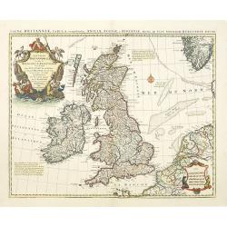
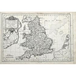
Magnae Britanniae Tabula, comprehendens Angliae, Scotiae ac Hiberniae.
The 1702 Delisle general map of the British Isles, copied by Pierre Mortier in 1702 and here in a second state with the address of Jean Covens and Cornelis Mortier.The Am...
Date: Amsterdam, ca. 1780
Selling price: ????
Please login to see price!
Sold in 2010

J.Anckerstöm a killer of King Gustave III.
Uncommon and decorative aquatint full length portrait of J.Anckerstöm. This aquatint by T.C. Lotter was made after a design of Witterquits.Gustav III (1746 – 1792) was...
Date: Augsburg, 1780
Selling price: ????
Please login to see price!
Sold in 2014
Los reynos de España y Portugal, según las últimas y nuevas observaciones de las Academias de Paris y de Londres.
Very rare, likely separately issued map of Spain and Portugal with text in Spanish. Based on a map by William Faden from London.
Date: Spain or London, c.1780
Selling price: ????
Please login to see price!
Sold in 2023
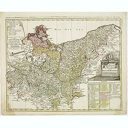
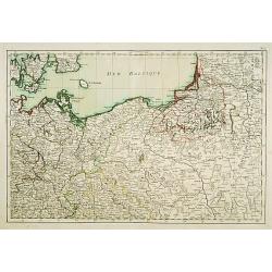
Der Nordliche Theil des Obersachsischen Kreises oder die Mark Brandenburg und das Herzogthum Pommern
Detailed map of Northern Germany, including Pomerania, Rugen, Brandenburg, etc. Centered on Berlin and the Oder River, it shows towns, roads, rivers, lakes, mountains, is...
Date: Nuremberg, 1780
Selling price: ????
Please login to see price!
Sold in 2012
A View of the Royal Exchange , London. Vue de la bourse royal a Londres. . .
So-called optical print of London with a view of Cornhill and the Exchange, with St. Paul's visible in the distance - horse-drawn traffic laboring along the road.The imag...
Date: Paris, ca. 1780
Selling price: ????
Please login to see price!
Sold in 2023

Hotel des Monnoies, Projete sur le Terrein de l'Hotel de Conty
Very large copper engraving featuring a view of the Hotel de Monnaies, a C-shaped mansion with steps outside the courtyard. The engraver was Claude Rene Gabriel Poulleau ...
Date: Paris, c1780
Selling price: ????
Please login to see price!
Sold in 2020
Carte de Moscovie.
Important,very large map of the Russian Empire in Europe. The copper engraved map covers present-day Russia, Lithuania, Estonia, Poland, Lapland, Lavia and part of Scandi...
Date: Paris, 1780
Selling price: ????
Please login to see price!
Sold in 2016
Suite de L'Histoire de Rome, Depuis L'An 3565 Jusqu'a l'An 3591.
Pleasant hand-colored copper engraved map of ancient Rome. With lovely floral ribboned border, engraved separately. Text in French. Louis Charles Desnos (1725-1805) was ...
Date: Paris, 1780
Selling price: ????
Please login to see price!
Sold in 2015
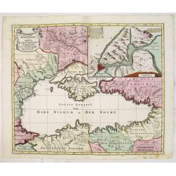
Nova Mappa Maris Nigri et Freti Constantino Politani. . .
Decorative and uncommon map the Black Sea region. In upper left hand corner an inset map (200x280) of the Bosporus including Istanbul. Title engraved onto a drape-style c...
Date: Augsburg, 1780
Selling price: ????
Please login to see price!
Sold in 2015
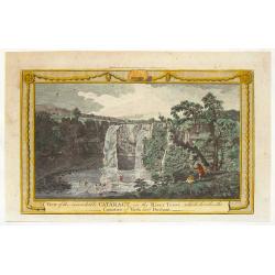
View of the Remarkable Cataract on the River Teese, Which Divides the Counties of York and Durham.
Fine hand-colored, copper engraved print of an inviting view of a waterfall being viewed by two spectators and two fishermen. The print was engraved for "The Complet...
Date: London, c. 1780
Selling price: ????
Please login to see price!
Sold in 2015
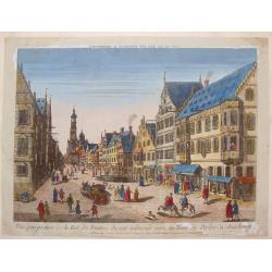
Vue Perspective de la Rue des Peintres du Cote Inferieur Vers la Tour de Perlac à Augsbourg.
A striking copper engraved print of the streets of Augsbourg, printed in Paris by Jacques Chereau. "Vue’D’Optique" optical view prints are views used in a ...
Date: Paris, 1780
Selling price: ????
Please login to see price!
Sold in 2013
Vue de la Partie Septentrionale du Fosse et des Murs D'Ausbourg Qui Separent la Basse Ville du Faubourg St. Jacques.
A striking copper engraved print of the river separating Augsburg, Germany from Faubourg, printed in Paris by Basset."Vue’D’Optique" optical view prints are...
Date: Paris, 1780
Selling price: ????
Please login to see price!
Sold in 2016
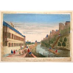
'T Gesiaht van 't Binnen Hof Siende na de Zaal en Fransche Kerk Vue du Dedans de la Cour Vers la Sale &. l'Eglise Françoise
Decorative bird's-eye view of 't Binnen Hof in The Hague.In the eighteenth and nineteenth centuries there were many popular speciality establishments in Paris, Augsburg a...
Date: Italy, ca. 1780
Selling price: ????
Please login to see price!
Sold in 2014
Vue de la Ville de Tobolsk.
Representation of the city Tobolsk in Russia. Engraved by François Denis Nee, after Nicolas Louis de Lespinasse (1737-1808). Published in "Historique physique, mora...
Date: 1780
Selling price: ????
Please login to see price!
Sold in 2014
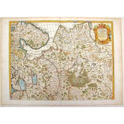
Golfo di Finlandia colle Provincie della Finlandia russa, Carelia, Ingria, Estonia, Nylandia.
Detailed map of the Gulf of Finland, with St. Petersburg in the east. With Helsinki, Tallinn and Haapsalu in Estonia.
Date: Venice, 1780
Selling price: ????
Please login to see price!
Sold in 2014
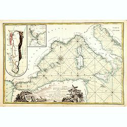
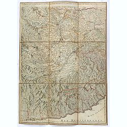
.Carte reduite de la partie occidentale de la mer Mediterranée.
Scarce chart of the Mediterranean published by André Basset. With insets of "Detroit de Gibraltar." and "Plan de Gibraltar". According to the title &...
Date: Paris, 1780
Selling price: ????
Please login to see price!
Sold in 2016
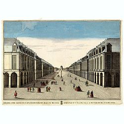
Delineatio Alicuyus Spatii Petersburgi in Russia. / Dibuxo d'una plaça a Petersburg en Russia.
Print of a street in Petersburg in Russia.By Giuseppe Remondini (1745-1811) was a well-known Italian publisher of optical prints. In the eighteenth and nineteenth centuri...
Date: Augsburg, 1780
Selling price: ????
Please login to see price!
Sold in 2016

Prospectus partis interioris Templi Carthusiae Papiensis in Italy / Vue perspective du dedans de L'eglise des Chartreux de Pavie en Italie.
So called optical print by the famous Italian publishing firm Remondini.Giuseppe Antonio Remondini (1634 -1711), around 1660, founded a printing office where he developed...
Date: Bassano del Grappa, 1780
Selling price: ????
Please login to see price!
Sold in 2015
![[Marco square in Venice.]](/uploads/cache/36224-250x250.jpg)
[Marco square in Venice.]
So called optical print by the famous Italian publishing firm Remondini.Giuseppe Antonio Remondini (1634 -1711), around 1660, founded a printing office where he developed...
Date: Bassano del Grappa, 1780
Selling price: ????
Please login to see price!
Sold in 2015
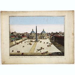
Prospectus Magni Fori, vulgo Piazza del Popolo, Rome. Veduta della gran Piazza del Popolo, in Roma. N 4.
View of Rome with the Piazza del Popolo. So called optical print by the famous Italian publishing firm Remondini.Giuseppe Antonio Remondini (1634 -1711), around 1660, fou...
Date: Bassano del Grappa, 1780
Selling price: ????
Please login to see price!
Sold in 2015
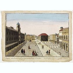
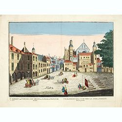
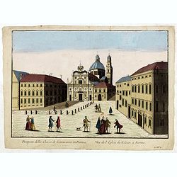
Prospetto della Piazza grande con li suoi condotti di aque, ed' imondizie in Parma.
View of Giuseppe Garibaldi square in Parma, with captions in Italian and French below image, without address. “Ll. No. 1” in lower right bottom. So called optical pri...
Date: Bassano del Grappa, 1780
Selling price: ????
Please login to see price!
Sold in 2015
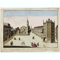
Prospetto della Chiesa Cattedrale con sua piazza con l'antica Capella in Parma.
View of Piazza Duomo con il Battistero in Parma, with captions in Italian and French below image, without address. “Ll. No. 2” in lower right bottom. So called optica...
Date: Bassano del Grappa, 1780
Selling price: ????
Please login to see price!
Sold in 2015
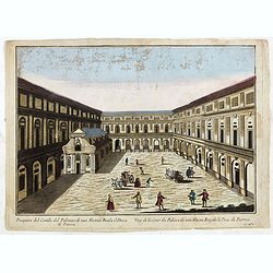
Prospetto del Cortile del Palazzo di sua Altezza Reale il Duca di Parma.
View of the Palace of the Duc of Parma, with captions in Italian and French below image, without address. “Ll. No. 3” in lower right bottom. So called optical print b...
Date: Bassano del Grappa, 1780
Selling price: ????
Please login to see price!
Sold in 2015
Prospetto della Chiesa di S. Gioavanni in Parma.
View of the S. Giovanni Church in Parma, with captions in Italian and French below image, without address. “Ll. No. 4” in lower right bottom. So called optical print ...
Date: Bassano del Grappa, 1780
Selling price: ????
Please login to see price!
Sold in 2015
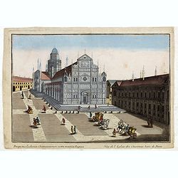
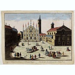
Prospectus Ecclesiae chartusianorum extra moenia Papiae. Vue de l'eglise des Chartreux hors de Pavie.
View of the Pavia Cathedral, with captions in Italian and French below image. So called optical print by the famous Italian publishing firm Remondini.Giuseppe Antonio Rem...
Date: Bassano del Grappa, 1780
Selling price: ????
Please login to see price!
Sold in 2015
Prospectus Ecclesiae Carmelitarum, et SS Trinitatis Papiae. Vue des Eglise des Carmes, et de la Trinité Pavie
View of the Church Of Santa Maria Del Carmine in Pavia, with captions in Italian and French below image. "Z N° 1." in lower left corner.So called optical print...
Date: Bassano del Grappa, 1780
Selling price: ????
Please login to see price!
Sold in 2015
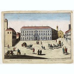
Prospectus Collegii Borromaei Papaiae. Vue du Collége Borromée a Pavie.
View of the Collegio Borromeo in Pavia, with captions in Italian and French below image. "Z N° 2." in lower left corner.So called optical print by the famous I...
Date: Bassano del Grappa, 1780
Selling price: ????
Please login to see price!
Sold in 2015
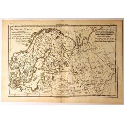
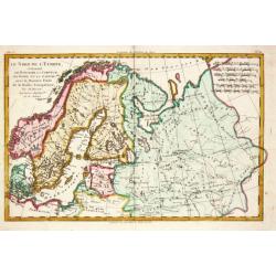
Le Nord de L'Europe
A fine map of Northern Europe and European Russia. It covers the modern day countries of Norway, Sweden, Finland, Denmark, and Finland as well as parts of Russia (includi...
Date: Paris, 1780
Selling price: ????
Please login to see price!
Sold in 2015
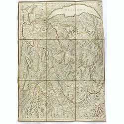
Les duchés de Savoye, de Genevois, de Chablais, les comtés de Maurienne, de Tarentaise et la baronie de Faucigny, le bailliage de Gex et la Seigneurie de Genève.
Uncommon folding case map showing the region of Pays de Gex et le Genevois, le Chablais et le Faucigny, la Savoie, la Maurienne et la Tarentaise. Prepared by H.Jaillot an...
Date: Paris, ca. 1780
Selling price: ????
Please login to see price!
Sold in 2016
Les Estats de Savoye et de Piémont. Le Dauphiné, la Bresse partie de Linois et de la Provence
Uncommon folding case map showing the region of Pays de Gex et le Genevois, le Chablais et le Faucigny, la Savoie, la Maurienne et la Tarentaise. Prepared by H.Jaillot an...
Date: Paris, ca. 1780
Selling price: ????
Please login to see price!
Sold
La Principauté de Piémont, les Marquisatsde Saluce et de Sueze, les Comtés de Nice et d'Ast, le Montferrat.
Uncommon folding case map showing the region of Pays de Gex et le Genevois, le Chablais et le Faucigny, la Savoie, la Maurienne et la Tarentaise. Prepared by H.Jaillot an...
Date: Paris, ca. 1780
Selling price: ????
Please login to see price!
Sold in 2016