Browse Listings in Europe
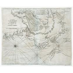
A Chart of the Seacoasts of Ireland from Dublin to London Derry.
Map showing the Irish coast from Dublin heading northeast to the city of Londonderry. The inset, partitioned with a leafy garland, details the passageway leading to Londo...
Date: London, 1750
Selling price: ????
Please login to see price!
Sold in 2010
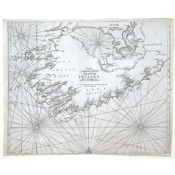
The Southwest Coast of Ireland from Dungarvan to the River Shannon.
Map showing the southwest coast of Ireland and cities within Waterford, Cork and Kerry counties. An inset at the top of the map, divided with a leafy garland, details the...
Date: London, 1750
Selling price: ????
Please login to see price!
Sold in 2010
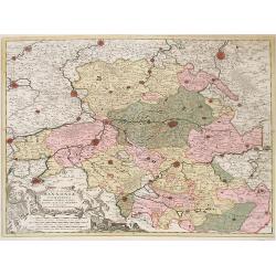
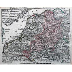
Nova et Accurata Hannonia Comitatus.
Detailed map of Belgium region centered around the city of Bergen Mons (Mons) in the center area of map. Also includes the cities of Douay (Douai), Valencienne and Brusse...
Date: Antwerp, 1720-1750
Selling price: ????
Please login to see price!
Sold in 2010
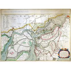
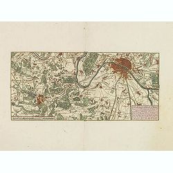
Tabula Castelli ad Sanflitam, qua fimul inundati agri, alluvio nes, fossae, alvei, quae Bergas ad Zomam et Anverpiam interjacent, annotantur. . .
Fine, beautifully colored map of the Antwerp region of Belgium. Fleets of ships are depicted sailing in and out of the city of Antwerp. The city of Bergen op Zoom is also...
Date: Amsterdam, c. 1750
Selling price: ????
Please login to see price!
Sold in 2010
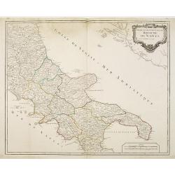
Partie septentrionale du Royaume de Naples.
Map of the southern part of Italy with Naples.
Date: Paris, c.1750
Selling price: ????
Please login to see price!
Sold in 2011
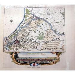
PLAN EN PROFIL DER BEROEMDE STADT DANTZIG derselver WERDERS, en omleggende Landen,...
SCARCE map of Danzig (Gdansk) in Poland. Superbly engraved and very detailed map of the city and its surroundings, showing small towns with single buildings, fields, woo...
Date: Amsterdam, ca. 1750
Selling price: ????
Please login to see price!
Sold in 2010
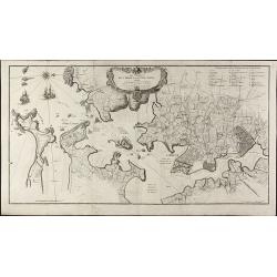
Les Environs de l'orient et du Port Louis. Dédiés à Monseigneur le comte d'Argençon Ministre et Secretaire d'Etat de la Guerre
A very large and rare map of Port Louis and Lorient by Le RougeThe copper engraved map published by G. L. le Rouge in 1750 and printed from two plate. It shows the area a...
Date: Paris, 1750
Selling price: ????
Please login to see price!
Sold in 2010
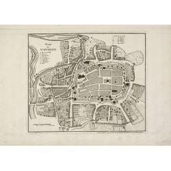
Plan de Schweidniz.
A rare plan of Schweidnitz (today Swidnicaat) in Silesia by Le Rouge. Showing the fortified city. With a key from A to H. We only could locate one copy of this plan in th...
Date: Paris, 1750
Selling price: ????
Please login to see price!
Sold in 2015
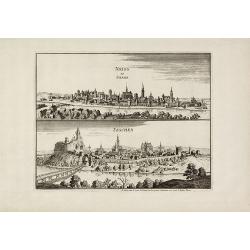
Neiss en Silesia / Teschen.
Very rare city views of Neisse (today Nysa) and Teschen (today Cieszyn) in Silesia after Merian by Le Rouge. Showing the prospects of both cities on one sheet. We only co...
Date: Paris, 1750
Selling price: ????
Please login to see price!
Sold in 2010
Carte Géometrique de la Ville et des Environs de Gene, ou on voit l'Expedition des Imperiaux et Piemontois contre les Genois et leurs alliez, avec les differents Postes, Retranchements, attaques, déffenses, et Mouvements des deux Parties, le tout desine s
RARE and unidentified map of the area around Genoa (Genova) in Italy. Large map, superbly engraved. With an extensive key to the right, identifying numerous fortification...
Date: ca. 1750
Selling price: ????
Please login to see price!
Sold in 2011
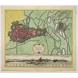
Stadt und Vestung Strasburg samt dem Fort Kehl.
Scarce decorative town-plan of Strasbourg with fine panoramic view of the city.
Date: Nuremberg, 1750
Selling price: ????
Please login to see price!
Sold in 2011
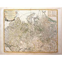
Tabula Geographica qua pars Russiae Magnae. . .
Homann's map is based upon the works of George von Mengden (1628-1702) a Livonian cartographer who worked for Peter the Great and Count Jacob Bruce [Graf Jakov Villimovic...
Date: Nuremberg, after 1750
Selling price: ????
Please login to see price!
Sold in 2010
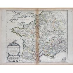
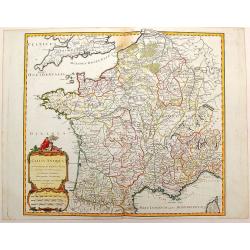
Gallia Antiqua in Provincias et Populos divisa. . .
Large map of Ancient France, divided into provinces, published in de Vaugondy's Atlas Universal. Includes towns, mountains, rivers, lakes and other details. Decorative ti...
Date: Paris, 1750
Selling price: ????
Please login to see price!
Sold in 2010
Tabulae principatus Brandenburgico culmbacensis sive baruthini. . .
Decorative map of Upper Franconia. The map was prepared by J. A. Riediger. From Graefental to Lauf, from Eger to Lichtenfels. Very decorative title cartouche with allegor...
Date: Nuremberg, 1750
Selling price: ????
Please login to see price!
Sold in 2023
Principatus silesiae Schwidnicencis. . .
Detailed map centered on Swidnica, south-west of Breslau (Wroclaw). Published in Atlas Silesiae Id Est Ducatus Silesiae Generaliter Quatuor Mappis Nec Non Specialiter XVI...
Date: Nuremberg, 1750
Selling price: ????
Please login to see price!
Sold in 2011
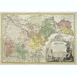
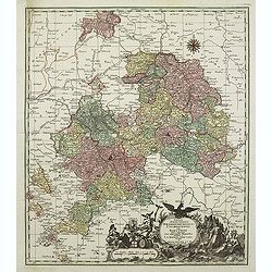
Principatus silesiae Bregensis. . .
Detailed map centered on Brzeg, south east of Breslau (Wroclaw). Published in Atlas Silesiae Id Est Ducatus Silesiae Generaliter Quatuor Mappis Nec Non Specialiter XVI Ma...
Date: Nuremberg, 1750
Selling price: ????
Please login to see price!
Sold in 2011
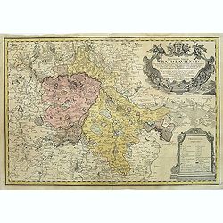
Principatus Silesiae Wratislaviensis exactissima tabula geographica. . .
Beautiful large scale map of Silesia, centered around Breslau (Wroclaw) with the River Oder. Published in Atlas Silesiae Id Est Ducatus Silesiae Generaliter Quatuor Mappi...
Date: Nuremberg, 1750
Selling price: ????
Please login to see price!
Sold in 2011
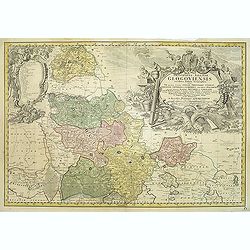
Principatus Silesiae GLOGOVIENSIS novissima Tabula Geographica sistens VI ejusdem Circulos Glogau Freystadt Guhrau Sprottau Grünberg et Schwiebus cum Districtu Polckwitz nee non Liberam Dynastiam Beuthen et Carolath. . .
Detailed map of principality of Grünberg, with an impressive oversized title cartouche depicting the principal coat of arms, gun, spear and game hinting on an area of am...
Date: Nuremberg, 1750
Selling price: ????
Please login to see price!
Sold in 2011
Carte du Diocese de Breslau avec fes IV Arcbidiaco- riats, subdivises en fes cercles archipresbyteriales. . .
Detailed map centered on Breslau (Wroclaw). Beautiful title cartouche in the lower left corner. With a key to the right. Number 4 in left and right lower corners.Publishe...
Date: Nuremberg, 1750
Selling price: ????
Please login to see price!
Sold in 2011
Silesiae Iavoriensis in IV Circulos, Iaver, Hirschberg, Lemberg und Buntzlau divisi ac. . .
Detailed map centered on Jelenia Góra ( Hirschberg), in southwestern Poland. The Sudeten (Sudety) mountains near the Czech border, pictorarily shown.Published in Atlas S...
Date: Nuremberg, 1750
Selling price: ????
Please login to see price!
Sold in 2011
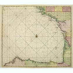
Nieuwe Generale Paskaart van de Bocht van Vrankryk Biscaia en Gallissia tussen I. de Ouessant en C. de Finisterre.
Rare of the Gulf of Biscay including all the south-west coast of France from Brest to the south and continuing along the Spanish coast, including Bilbao, until Ferrol. I...
Date: Amsterdam, ca. 1750
Selling price: ????
Please login to see price!
Sold in 2011
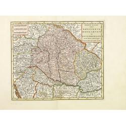
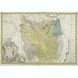
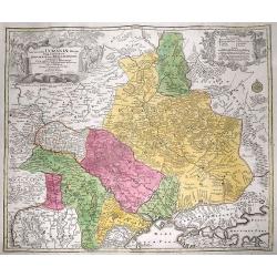
Nieuwe kaart van.. Hongaryen en Sevenbergen. . .
Detailed map of Hungary in attractive full original colors. Isaak Tirion was born in Utrecht ca. 1705. He came to Amsterdam ca. 1725. Tirion published a number of importa...
Date: Amsterdam, 1750
Selling price: ????
Please login to see price!
Sold in 2023
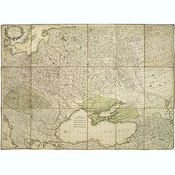
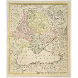
Carte du théatre de la guerre presente entre les Russes, les Polonois et les Turcs. . .
Map of region between the Baltic sea and the Black Sea, published by Jean Lattré and prepared by R. Bonne. The map allowed the French public to follow the Russo-Turkish ...
Date: Bordeaux, c.1750
Selling price: ????
Please login to see price!
Sold in 2011
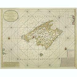
Nieuwe Afteekening van het Eyland Maiorca
So called "Blue-back" sea- of Majorca.Latitude scale, compass rose and system of rhumb lines, soundings, anchorage's, etc. A wealth of cities and information ap...
Date: Amsterdam, 1750
Selling price: ????
Please login to see price!
Sold in 2011
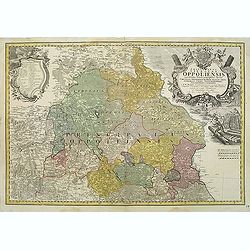
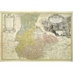
Schlesien Oppeln- 'Principatus Silesiae Oppoliensis exactissima Tabula geographica, sistens Circulos Oppoliensem, Ober-Glogau Gros Strehliz, Cosel, Tost, Rosenberg, Falckenberg & Lubleniz. . .
Detailed map of Southern Poland region of Oppeln. Published in Atlas Silesiae Id Est Ducatus Silesiae Generaliter Quatuor Mappis Nec Non Specialiter XVI Mappis Tot Princi...
Date: Nuremberg 1736 / 1750
Selling price: ????
Please login to see price!
Sold
Principatus Silesiae Teschinensis nova et accurata delineatio distincte insimul exhibens Status minores. . .
Detailed map centered on the Duchy Teschen in Austrian Silesia. Published in Atlas Silesiae Id Est Ducatus Silesiae Generaliter Quatuor Mappis Nec Non Specialiter XVI Map...
Date: Nuremberg, 1736 / 1750
Selling price: ????
Please login to see price!
Sold in 2012
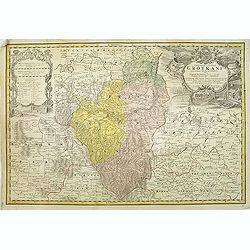
Principatus Silesiae Grotkani exactissima tabula geographica exhibens terram Nissensem simul. . .
Detailed map centered on the region Neisse (Nysa), Grottkau, Ottmachau and Ziegenhals in Poland. Published in Atlas Silesiae Id Est Ducatus Silesiae Generaliter Quatuor M...
Date: Nuremberg, 1736 / 1750
Selling price: ????
Please login to see price!
Sold
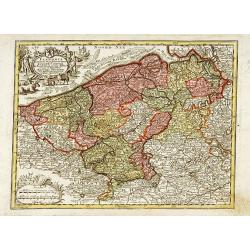
Flandria maximus et pulcherrimus. . .
Flanders: the liberty of Bruges with the island of Cadzand. A decorative map including the towns of Gent, Sluis, Bruges, Ostend, Brussels, Lille, Dunkerque and many other...
Date: Augsburg 1750
Selling price: ????
Please login to see price!
Sold in 2023
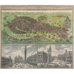
Venetia Potentissima e la più Magnifica...
Striking hand-colored bird's town-plan of Venice with two views of St. Mark's Square (Piazza San Marco), one showing the famous "Gondolas". The detailed plan in...
Date: Augsburg, c.1750
Selling price: ????
Please login to see price!
Sold in 2011
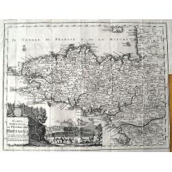
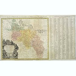
Carta Geografica del Governo della Bretagna.
Attractive and detailed map, showing Brittany divided into its bishoprics and with all towns and cities. Extending to Jersey. With a decorative title cartouche and a view...
Date: Venice, c1750
Selling price: ????
Please login to see price!
Sold in 2011
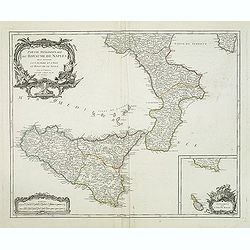
Partie méridionale du royaume de Naples où se trouvent la Calabre et l'isle et royaume de Sicile. . .
Detailed map of Calabria and Sicily, and inset map with Malte Islands. Dated 1750.Ornated with a large title cartouche and a scale cartouche in the left corners. Inset ma...
Date: Paris, 1750
Selling price: ????
Please login to see price!
Sold in 2011
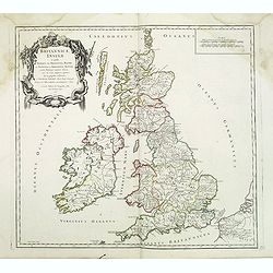
Britannicae, Insulae in quibus Albion sen Britannia Major, . . .
British Isles from his "Atlas Universel".Gilles Robert de Vaugondy (1688–1766), also known as Le Sieur or Monsieur Robert, and his son, Didier Robert de Vaugo...
Date: Paris, 1750
Selling price: ????
Please login to see price!
Sold in 2016
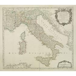
L'Italie qui comprend les états de Piémont. . .
Detailled map of Italy, including the island of Corsica, Sardaigna and Sicily from his "Atlas Universel".Gilles Robert de Vaugondy (1688–1766), also known as ...
Date: Paris, 1750
Selling price: ????
Please login to see price!
Sold in 2018
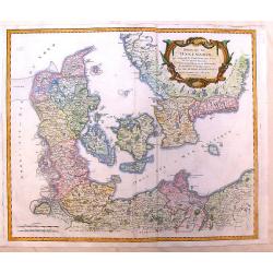
Royaume de Danemark. . .
Detailed map of Denmark, including the Baltic Sea and part of Sweden. Showing towns, rivers, mountains, ports, islands, etc. Large title cartouche, with erased date and p...
Date: Paris, c.1750
Selling price: ????
Please login to see price!
Sold in 2013
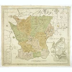
Charta öfwer Skåne. Med Kongl. Maj.ts. nådigste privilegio utgifven af Kongl. Landtmäteri Contoiret.
A scarce map of the district of Skåne in Sweden. A large title cartouche lower right and a key in the lower left corner. The map is a part of a work by Kongl. Landtmäte...
Date: Stockholm, c.1750
Selling price: ????
Please login to see price!
Sold in 2013
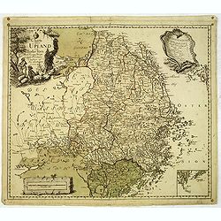
Charta öfwer Upland och Söder Törn. Med Kong. Maj.ts. Nådigste privilegio utgifven af Kongl. Landtmäteri Contoir.
A scarce map of the district of Upland in Sweden. A large title cartouche upper left and a key in the upper right corner. The map is a part of a work by Kongl. Landtmäte...
Date: Stockholm, c.1750
Selling price: ????
Please login to see price!
Sold in 2012
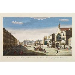
A View of the grand Palace of Westminster. / Vüe du Palais Episcopal de Westminster.
So-called optical print illustrating a perspective view of the old Palace of Westminster where the Lords and Commons met and the square facing it.In the eighteenth and ni...
Date: London, c.1750
Selling price: ????
Please login to see price!
Sold in 2019
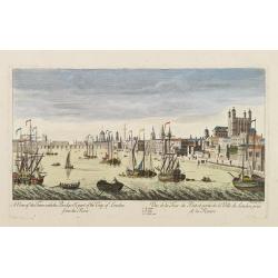
A View of the Tower with the Bridge & part of the City of London from the River. Vue de la Tour du Pont et partie de la Ville de Londres prise de la Riviere.
So-called optical print illustrating part of the city of London, taken from the river Thames. With numbered key list. Engraved by Charpentier.In the eighteenth and ninete...
Date: London, c.1750
Selling price: ????
Please login to see price!
Sold in 2013
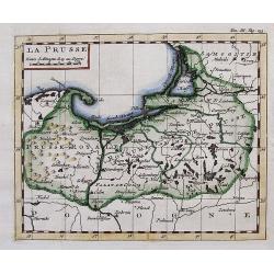
LA PRUSSE.
Interesting small map with parts of today Poland, Kaliningrad Oblast, and Lithuania. Detailed map, includes the cities of Gdansk, Konigsberg (Kaliningrad), Memel (Klaiped...
Date: ca. 1750
Selling price: ????
Please login to see price!
Sold in 2012
A Survey of the City and Suburbs of Bristol Survey'd by John Rocque Land Surveyor at Charing Cross, 1750 / Plan de la Ville et Faubourgs de Bristol Leve par Jean Rocque a Charing Cross a Londres 1750
Rare "carte à figures"- map of Bristol by J. Rocque.A large and detailed copper engraved map of the city and suburbs of Bristol, draw, surveyed and published b...
Date: London, 1750
Selling price: ????
Please login to see price!
Sold in 2012
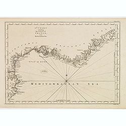
13th Chart including the coast of France, in the mediterranean sea.
Engraved chart of the coast of Provence and Languedoc, France, engraved by Thomas Jeffery's.
Date: London, ca.1750
Selling price: ????
Please login to see price!
Sold
Londinum Londen.
Rare view of London, in nice hand coloring.
Date: Augsburg, 1750
Selling price: ????
Please login to see price!
Sold in 2012
Amplissima Ucraniae Regio, Palatinatus Kioviensem et Braclaviensem...
An uncommon and attractive map of the Ukraine. With excellent detail of the topography, including rivers, hills, etc. Decorated with two attractive cartouches showing...
Date: Augsburg, c1750
Selling price: ????
Please login to see price!
Sold in 2012
Gallia Antiqua in Provincias et Populos Divisa
This large map of the Roman time Gauls (Gallia) dated 1750, was incorporated in the 1st edition of "Atlas Universel" in 1757. With significant portions of Belgi...
Date: Paris, 1750
Selling price: ????
Please login to see price!
Sold in 2015
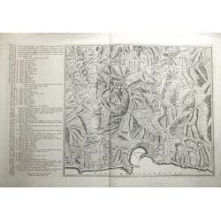
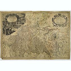
![[No tittle] Folding map centered on the Bodensee, Zurichersee](/uploads/cache/30634-250x250.jpg)
[No tittle] Folding map centered on the Bodensee, Zurichersee
Beautiful and detailed map of the area around the Bodensee, including Konstanz, Liechtenstein, Zurich and Fussen in the east, etc More about folding maps. [+]
Date: Germany, ca. 1750
Selling price: ????
Please login to see price!
Sold in 2013
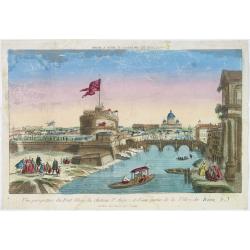
Vue perspective du pont Elian, du château St Ange, et d'une partie de la ville de Rome.
A view of the Castle of St.Angelo and Elian Bridge, with part of the city of Rome. Published by Jacques Chereau, who was a well-known publisher of optical prints, establi...
Date: Paris, ca. 1750
Selling price: ????
Please login to see price!
Sold in 2016
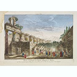
Ruine du Temple de Jupiter Olimpien à Athênes les Turcs en sont aujour d'huy une rue quil leur sert de Marché aux fruits et aux legumes.
Optical print of the ruins of the Temple of Jupiter Olympius in Athenes. This famous temple was build by Antiochus. Published by Jacques Chereau, who was a well-known pub...
Date: Paris, ca. 1750
Selling price: ????
Please login to see price!
Sold in 2016
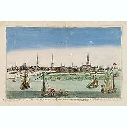
Hambourg, ville d'Allemagne dans le duché de Holstein. . .
Showing the town of Hamburg seen from the river Elbe. Optical print published by Mondhare, who was a well-known publisher of optical prints, established in rue St. Jacque...
Date: Paris, ca. 1750
Selling price: ????
Please login to see price!
Sold in 2015
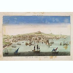
Vue de la ville de Naples. . .
A decorative view of Naples with a busy harbour, published by Basset, who was a well-known publisher of optical prints, established in rue St. Jacques in Paris. In the ei...
Date: Paris, ca. 1750
Selling price: ????
Please login to see price!
Sold in 2014
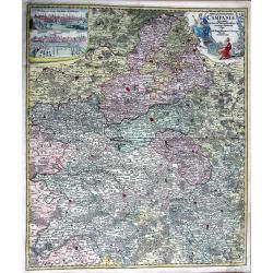
TABULA GEOGRAPHICA CAMPANIAE...
Decorative copper engraved map of Champagne. Very detailed, covering the region Champagne-Ardenne with Reims, Troyes, Châlons, Vitry, and Épernay. With an allegoric tit...
Date: Nuremberg, 1750
Selling price: ????
Please login to see price!
Sold in 2013
Nieuwe kaart van Parys en Versailles met de nabygelegen Landstreek en Plaatsen.
Very detailed map covering the vicinity of Paris from Versailles to Vincennes. Nice detail around Boid de Boulogne and St.Cloud
Date: Amsterdam, 1750
Selling price: ????
Please login to see price!
Sold in 2013
![Kaart van den loop der Rivieren de RHYN, de MAAS de MERWE, en de LEK. . . [together with] Kaart van de beneden Rivier de Maas. . . [together with] Nieuwe kaart van 't Kwartier Nijmegen . . .](/uploads/cache/33462-250x250.jpg)
Kaart van den loop der Rivieren de RHYN, de MAAS de MERWE, en de LEK. . . [together with] Kaart van de beneden Rivier de Maas. . . [together with] Nieuwe kaart van 't Kwartier Nijmegen . . .
1./ Kaart van den loop der Rivieren de RHYN, de MAAS de MERWE, en de LEK... (352x450mm.) A detailed map of the center of the Netherlands, with the rivers Rhine, Maas, de ...
Date: Amsterdam, 1750
Selling price: ????
Please login to see price!
Sold in 2013
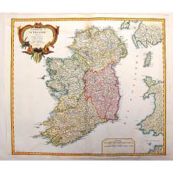
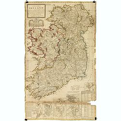
Royaume D'Irelande, Divisee en Ses Quatre Provinces.
A very precise and detailed map of Ireland by "Le Sieur". With large fancy title cartouche and scale table. One of the most beautiful maps of Ireland. Gilles R...
Date: Paris, 1750
Selling price: ????
Please login to see price!
Sold in 2013
Partie Occidentale de L'Empire de Russie
Detailed map of the western part of the Russian Empire, north of the Black & Caspian Seas, Nova Zembla and including most of Finland. Gilles Robert de Vaugondy (168...
Date: Paris, 1750
Selling price: ????
Please login to see price!
Sold in 2014
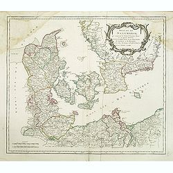
Royaume de Danemarck
Lovely map of Denmark that includes Schleswig-Holstein, the Pomeranian coast and Southern Sweden. Includes a fancy ribboned title cartouche.Gilles Robert de Vaugondy (168...
Date: Paris, 1750
Selling price: ????
Please login to see price!
Sold in 2014
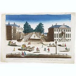
Vue du petit Voorhout une des promenades de La Haye prise du coté du pont Coucamp.
Showing the Voorhout in The Hague. Likely published by J. Chereau, who was a well-known publisher of optical prints, established in rue St.Jacques in Paris. In the eighte...
Date: Paris, ca. 1750
Selling price: ????
Please login to see price!
Sold in 2013
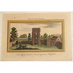
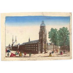
View of Godston Nunnery Near Oxford.
Pleasant hand-colored print of the famous "Godston Nunnery" close to Oxford in Oxfordshire. The print was by Samuel & Nathaniel Buck who sketched the ruins ...
Date: London, c1750
Selling price: ????
Please login to see price!
Sold in 2013
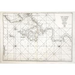
Carte générale des costes de l'Europe sur l'Ocean comprises depuis Dronthem en Norvege jusques au Detroit de Gibraltar.
General chart of the Atlantic coasts of Europe, from Trondheim in Norway to the Straits of Gibraltar. Prepared by Nicolas Bellin and engraved by H. van Loon.
Date: Paris, 1750
Selling price: ????
Please login to see price!
Sold in 2013
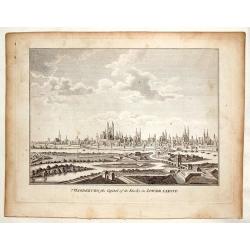
Magdenburg, the Capital of its Duchy in Lower Saxony.
This is a fine copper engraved view of Magdenburg featuring 19 churches with spires, several fortifications and a river system with 10 ships and boats.
Date: Nuremberg, c. 1750
Selling price: ????
Please login to see price!
Sold in 2016
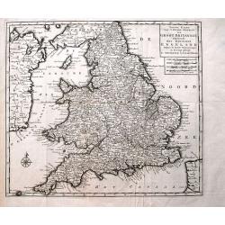
Nieuwe Kaart van 't Zuider Gedeelte van Groot Britannie behelzende Het Koningryk Engeland...
Detailed map of England and Wales, including parts of Ireland. Shows the Picts Wall (Hadrian's Wall)! With a wealth of place names, rivers, roads, areas, etc.
Date: Amsterdam, c1750
Selling price: ????
Please login to see price!
Sold in 2013

Vue Perspective de L'Interieur de L'Eglise des Invalides Prise Dessous les Orgues.
A Vue Optique featuring the interior of the Church of the Invalids in Paris. Jacques Chéreau (1688–1776) was a portrait engraver, printmaker and publisher of optical...
Date: Paris, 1750
Selling price: ????
Please login to see price!
Sold in 2018
ACCURATA ET NOVISFIMA REPRAEFENTATIO ICHNOGRAPHIEA HANNOVERAE.
Double-page engraved plan of Hanover by Tobias Conrad Lotter.Showing all the churches and notable places, with an inset decorative shield in the top right with details ab...
Date: Augsburg, 1750
Selling price: ????
Please login to see price!
Sold in 2014
Plan du siege de Corfu par Terre et par Mer...
This uncommon map depicts the western coast of Corfu, including Kérkira at the time of the siege on July 5th, 1716 against the Turkish marine. Part the Greek coast (prov...
Date: Nuremberg, 1750
Selling price: ????
Please login to see price!
Sold in 2015
Vereinigte Niederlande, Spanische Niederlande, Herzogt. Brabant, Herzogt. Luxemburg, Graefsch. Flandern.
Detailed miniature map published by Tobias Conrad Lotter and Tobias Lobeck in their "Atlas Geographicus portatilis...".
Date: Augsburg, ca. 1750
Selling price: ????
Please login to see price!
Sold in 2014
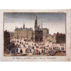
Il Palazzo Publico Della Citta di Amsterdam.
Very pleasing hand colored copper engraving of Amsterdam featuring the Palace.
Date: Venice, 1750
Selling price: ????
Please login to see price!
Sold in 2019
A new map of Ireland divided into its provinces, counties and baronies, wherein are distinguished the bishopricks, borroughs, barracks, bogs, passes, bridges &c. with the principal roads, and the common reputed miles
A magnificent and highly detailed late 18th century map of Ireland, with in lower right corner inset town plans of Dublin, Cork, Limerick, Waterford and Gallway, with pla...
Date: London, 1726-1750
Selling price: ????
Please login to see price!
Sold in 2015
The South East prospect of London, from the Tower to London Bridge.
Optical vue of the River Thames, looking to the west from the Tower of London to London Bridge and St Paul's; animated with a number of boats on the water.
Date: Londo, circa 1750
Selling price: ????
Please login to see price!
Sold in 2022
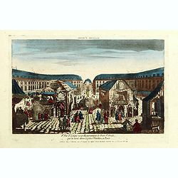
8e Vue d'optique nouvelle représentant la Foire St Ovide qui se tient dans la place Vendôme, à Paris.
Showing the St Ovide fair at the Vendôme Place in Paris. Likely published by J. Chereau, who was a well-known publisher of optical prints, established in rue St.Jacques ...
Date: Paris, ca. 1750
Selling price: ????
Please login to see price!
Sold in 2015
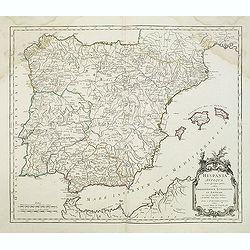
Hispania Antiqua.
Map of ancient Spain and Portugal. Engraved by G. Delahaye. From his "Atlas Universel".Gilles Robert de Vaugondy (1688–1766), also known as Le Sieur or Monsie...
Date: Paris, 1750
Selling price: ????
Please login to see price!
Sold in 2015
Vue Perspective de L'Universite d'Augsbourg Fonde par L'Eveque Julien.
Original antique print published by Chereau in Paris in c1750. This is an optical print, also called “Vue Optique” or “Vue d'Optique”, which were made to be viewe...
Date: Paris, c1750
Selling price: ????
Please login to see price!
Sold in 2019
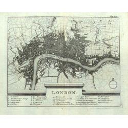
London.
Small French map of London with a key below naming 24 important places within the city. Numerous streets are indicated. Uncommon map, probably dating to around 1700-1750.
Date: Paris, ca. 1700-1750
Selling price: ????
Please login to see price!
Sold in 2016
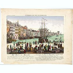
L'interieur du port de marseille...
A so-called optical print. A lively and harbor scene of Marseille, with many people loading a vessel. Engraved by Balthazar Frederic Leizelt.. The image is actually of a...
Date: Augsburg, c. 1750
Selling price: ????
Please login to see price!
Sold in 2016
Tabula Geographica Europae. . .
Interesting map in four sheets, forming a map of Europe, including good detail on Scandinavia, Russia, Poland with a decorative title cartouche, and a Prussian duty stamp...
Date: Berlin, ca. 1750
Selling price: ????
Please login to see price!
Sold in 2017
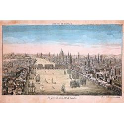
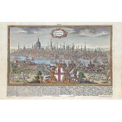
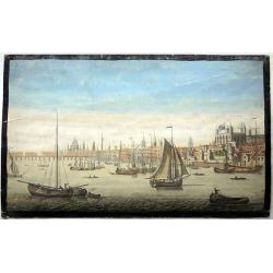
Vue generale de la ville de Londres
A 'bird's-eye' view of London, taken from a point several hundred feet above Tower Bridge. Note: St. Paul's church, the Monument to the fire of London, and Westminster Ab...
Date: Paris, ca 1750
Selling price: ????
Please login to see price!
Sold in 2016
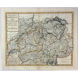
Nuova Carta dei XIII Cantoni degli Svizzeri infieme coi loro Alleati e Sudditi.
Taken from Volume II of Albrizzi's "Atlante Novissimo" after Guillaume de L'Isle. Showing Switzerland divided into its various cantons, with major towns, cities...
Date: Padua, 1750
Selling price: ????
Please login to see price!
Sold in 2016
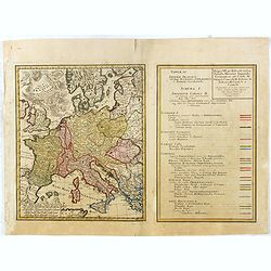
Tab. IV Imperii Francici vel Romano German f. Romani Occid . . .
Uncommon map and table depicting the divisions of Europe, during the reign of the Holy Roman Emperor Charles V.
Date: Nuremberg / 1750
Selling price: ????
Please login to see price!
Sold in 2017
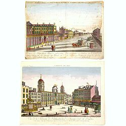
Two Optical prints of London
Two optical prints "Prospect des Admiralitaets Hauses, nebst dem neuen Gebäu für die Quarde zu Pferd" and "Vue de la Maison de Northumberland à Charing ...
Date: Augsburg 1750
Selling price: ????
Please login to see price!
Sold in 2016
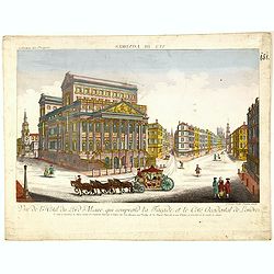
Vue de l Hotel du Lord Maire, qui comprend la Façade, et le Cot' Occidental de Londres.
Shows the famous Lord Mayor's coach driving through London. The Lord Mayor's coach is famous for its role in the Lord Mayor's Show, which is one of the longest establishe...
Date: Augsburg, 1750
Selling price: ????
Please login to see price!
Sold in 2016
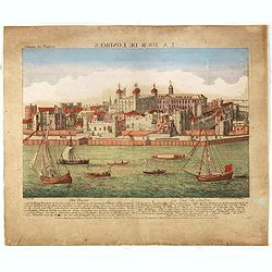
Der Tower La Tour de Londres.
Optical view by J.B. WINCKLER after L. KNYF, German and French captions below, In the eighteenth and nineteenth centuries there were many popular speciality establishment...
Date: Augsburg, 1750
Selling price: ????
Please login to see price!
Sold in 2016
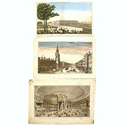
Three Optical prints of London. . .
Three optical prints of London "An Inside View of the Rotundo in London Caff. - Vue interieur de la Rotonde oú le Caffé", with "A View of the Royal Palac...
Date: London, ca. 1750
Selling price: ????
Please login to see price!
Sold in 2016