Browse Listings in Europe
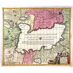
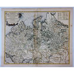
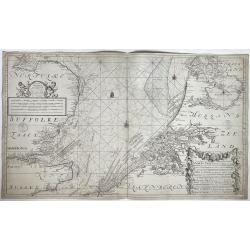
Nova et Accuratissima Maris Caspii....
Highly decorative map showing the Caspian Sea and the countries around it. Main cities / countries around it include: Baky / Baku in Aserbaidschan, Astrakhan / Astrakha...
Date: Augsberg, 1750
Selling price: ????
Please login to see price!
Sold in 2016
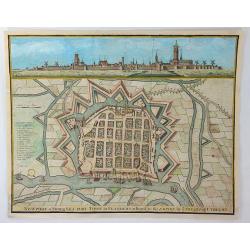
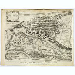
Newport a Strong Sea-Port Town in Flanders, Restored to the Empire by the Treaty of Utrecht.
A hand colored plan of Newport, a sea port town of Flanders from Tindal's Continuation of Mr. Rapin's "HISTORY OF ENGLAND". Engraved by James Basire in London c...
Date: London, ca. 1750
Selling price: ????
Please login to see price!
Sold in 2016
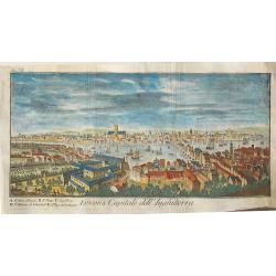
Londra, capitale dell'Inghilterra
A nice copper engraving depicting the city of London, from "Lo stato presente di tutti i paesi e popoli del mondo naturale, politico, e morale", printed in 1750...
Date: Venice, ca 1750
Selling price: ????
Please login to see price!
Sold in 2016
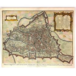
Ghent, a Large City and Castle in Flanders
A very fine bird's-eye plan of the city and fortifications of Ghent and the surrounding countryside in Belgium. A decorative cartouche encloses a detailed key to the map ...
Date: London, 1750
Selling price: ????
Please login to see price!
Sold in 2016
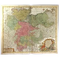
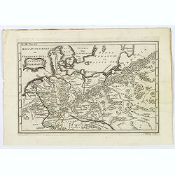
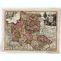
Saxoniae Inferioris circulus, exhibens ducatus Brunswic
This large detailed map of Saxony shows northern Germany with Sachsen Anhalt, Niedersachsen, Mecklenburg Vorpommern, Schleswig, Holstein, Brandenburg, Hamburg, Bremen and...
Date: Augberg, 1750
Selling price: ????
Please login to see price!
Sold in 2016

Carte du Kamtchatka
One of the best maps of the region from the 1700's. Handsome copper engraved map of the Kamtchatka peninsula with excellent detail showing topography, including several l...
Date: Paris, 1750
Selling price: ????
Please login to see price!
Sold in 2016
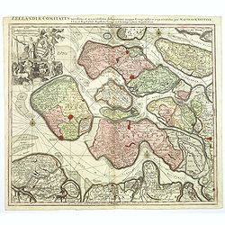
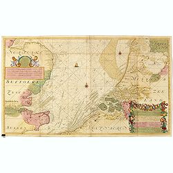
Zeelandiae Comitatus. . .
A scarce map of Zeeland, a section of south-western The Netherlands, published by Matthäus Seutter.Impressive cartouche with coat of arms of Zeeland top left, reflecting...
Date: Augsburg, ca.1750
Selling price: ????
Please login to see price!
Sold in 2017
Artsia cum Finitimis Locis Seden ac Thatrum Belli ...
A fine large map of the Pas-de-Calais / Artois region in northern France, and part of Belgium between Calais, Abeville and Douay, with decorative figural cartouche. By Co...
Date: Nüremburg, 1750
Selling price: ????
Please login to see price!
Sold in 2016
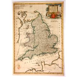
A New and Accurate Map of England.
Fine, very detailed map of England and Wales by Thomas Bowen in about 1750. It has a decorative cartouche with a cannon, a lion, a bust, a globe, and a three-lioned shiel...
Date: London, ca. 1750
Selling price: ????
Please login to see price!
Sold in 2017
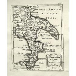
Gross Griechenland oder Apulien, Lucanien und Bruttium.
A rare map of soutern Italy. Shows the area from Apulia to Messina in Sicily, including Salerno, Paestum, Potenza, Bari, Tarent, Lamezia, Crotone, Reggio, and many more w...
Date: Anon, ca. 1750
Selling price: ????
Please login to see price!
Sold in 2018
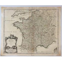
Le Royaume de France Divise Suivant les Gouvernemens Generaux.
A fine politically and topographically detailed 1750 map of France by Robert de Vaugondy. It covers all of France from the English Channel to Corsica and Spain.The map fe...
Date: Paris, 1750
Selling price: ????
Please login to see price!
Sold in 2017
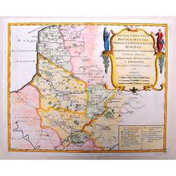
Partie Occidentale de L'Empire de Russie.
A highly detailed map of the Western Part of Russia, extending South to the Caspian and East to Irkurkoy and Ilimskoy. Interesting natural cartouche featuring two bears e...
Date: Paris, 1750
Selling price: ????
Please login to see price!
Sold in 2018
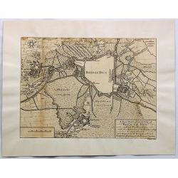
A New Plan of the Town of Bois le Duc and Its Fortifications.
Striking engraved plan showing the city of s'Hertogenbosch in Brabant, Netherlands. The map focuses on the town fortifications and also includes details of the town plan...
Date: London, J. Nourse, 1750
Selling price: ????
Please login to see price!
Sold in 2018
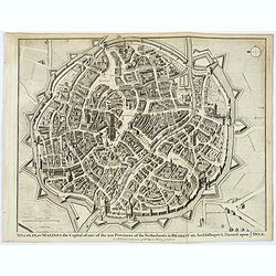
Mechlin, or Malines the Capital of one of the ten Provinces of the Netherlands. . .
A detailed 'bird's eye view of the Belgian city of Mechelen. Streets are named, and houses and buildings are shown in great detail. Prominent buildings shown. City walls ...
Date: London, ca 1750
Selling price: ????
Please login to see price!
Sold in 2020
Cony, a strong City of Piedmont in the States of Savoy.
A detailed 'bird's eye view of the Italian city of Cony (Cuneo) and surrounding fields, farmland rivers and terrain.Houses and public buildings are shown in great detail,...
Date: London, ca 1750
Selling price: ????
Please login to see price!
Sold in 2017
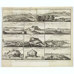
Views of the principal Towns and Castles in Scotland..
A delightful selection of 10 Scottish Towns, Castles, and of The Bass Rock. Towns include Edinburgh, Glasgow, Sterling, Aberdeen, St. Andrews, Montrose, Cannery Town in R...
Date: London, ca. 1750
Selling price: ????
Please login to see price!
Sold in 2021
Partie Orientale de L'Empire de Russie en Asie...
An attractive and detailed map of the northeastern portion of Asia, including Russia, China, the Gobi Desert, etc. Included are cities, villages, rivers, mountain ranges ...
Date: Paris, 1750
Selling price: ????
Please login to see price!
Sold in 2017
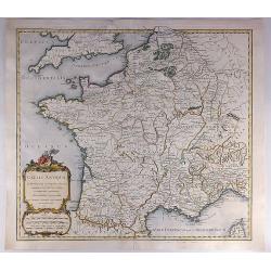
Gallia Antiqua in Provincias et Populos Divisa.
An attractive map of France or 'Gaul'. It features Gallia during ancient Roman times, and extends from the English Channel south as far as the Pyrenees Mountains and Hisp...
Date: Paris, 1750
Selling price: ????
Please login to see price!
Sold in 2023
![[Two maps] Tetrachia Ducatus Geldriae Neomagensis. / Transisalania vulgo Over-Yssel auct. N. ten Have. . .](/uploads/cache/40600-250x250.jpg)
[Two maps] Tetrachia Ducatus Geldriae Neomagensis. / Transisalania vulgo Over-Yssel auct. N. ten Have. . .
[Two maps] Frederick de Wit's very attractive map of the area of Nijmegen in The Netherlands. North is orientated to the upper right. The map is adorned with a banner sty...
Date: Amsterdam, ca. 1680 - 1750
Selling price: ????
Please login to see price!
Sold in 2018
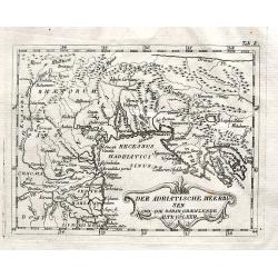
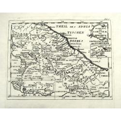
Der Adriatische Meerbusen und die daran graenzende Alte Völker.
A rare map of northern Italy. Shows the area from Brixen to Istria, including Verona, Venice, Trieste, and Pula, by an unidentified and unknown cartographer.
Date: Anon, ca. 1750
Selling price: ????
Please login to see price!
Sold in 2018
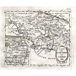
Land der Etrurier und Umbrier.
A rare map of central Italy. Shows the area from Porto Venere until Ancona, including Rome, Pisa, and Siena. An inset map shows the area around Rome. By an unidentified a...
Date: Anon, ca. 1750
Selling price: ????
Please login to see price!
Sold in 2018
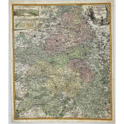
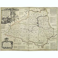
Tabula Geographica Campaniae in Suas Sic Dictas. . .
A map of Champagne, the famous wine provence in France. On the top left are insert views of Reims and Troyes, and a decorative cartouche featuring a king and his subjects...
Date: Nuremberg, ca. 1750
Selling price: ????
Please login to see price!
Sold in 2018
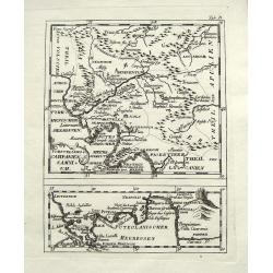
Wohnsitz der Sabiner, und ihrer Abkömlinge.
A rare map of central Italy. Shows the area from Ancona to Benevento, including Rome, Narni, Terni, Ortona, and many more with their old names. An inset map shows the Vel...
Date: Anon, ca. 1750
Selling price: ????
Please login to see price!
Sold in 2018
Vorstellung v. Campanien u. Samnium.
A rare map of the area around Naples. Shows the area from Città di Castello until Salerno. Includes Naples, Nola, Sorrento, islands of Capri and Ischia, and many more wi...
Date: Anon, ca. 1750
Selling price: ????
Please login to see price!
Sold in 2018
Madrit.
Very rare view of Madrid from Johann Friedrich Probst. Printed on two sheets. Different versions of this exceptional, large view of Madrid were produced by the Probst. No...
Date: Augsburg, ca 1750
Selling price: ????
Please login to see price!
Sold in 2021
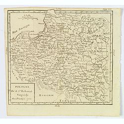
Pologne.
A compact small map of Poland, including Lithuania and Belarus, as they appeared in 1750. Dense detail provided, with topography, place names, rivers and lakes. A nice sm...
Date: Paris, 1750
Selling price: ????
Please login to see price!
Sold in 2019
Antient Germany.
A map of Germany in Roman times, that also shows Denmark and southern tip of Sweden, and parts of eastern Europe. With good map detail, including rivers, regions, towns, ...
Date: London, ca 1750
Selling price: ????
Please login to see price!
Sold in 2019
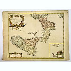
Partie Meridionale du Royaume de Naples. . .
A quite striking map of Sicily, Naples and neighbouring islands, with a large attractive inset of Malta, and extreme southern portion of Sicily, taken from an early editi...
Date: Paris, ca 1750
Selling price: ????
Please login to see price!
Sold in 2019
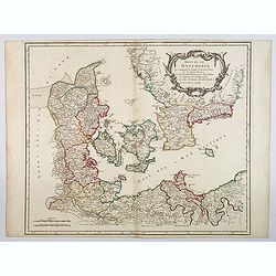
Royaume de Danemark. . .
A nice, detailed map of Denmark, including the Baltic Sea and the lower part of Sweden. Showing towns, rivers, mountains, ports, islands, etc. Adorned with a large title ...
Date: Paris, ca 1750
Selling price: ????
Please login to see price!
Sold in 2020
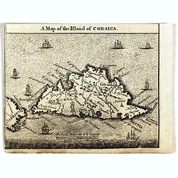
A Map of the Island of Corsica.
Scarce small map of Corsica and part of Sardinia.
Date: England, ca. 1750
Selling price: ????
Please login to see price!
Sold in 2019
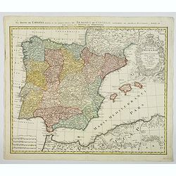
Regnorum Hispaniae et Portugalliae. . .
A beautifully detailed map of Spain and Portugal by Homann. It offers excellent detail of the Iberian Peninsula and the Balearic Islands, plus parts of southwestern Franc...
Date: Nuremberg, ca 1750
Selling price: ????
Please login to see price!
Sold in 2021
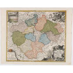
Mappa Geographica Totius Regni Bohemiae In XII Circulos divisae annexisComitatuGlacensi et Districtu Egerano . . .
Uncommon map of the Czech Republic, centered on Prague. Includes four ornate cartouches, coat of arms and a birdseye view of the Bridge across the Moldau River in Prague.
Date: Augsburg, 1750
Selling price: ????
Please login to see price!
Sold in 2020
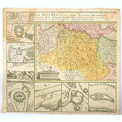
Regnum Bosniae , una cum finitimis Croatiae, Dalmatiae. . .
One half of a large two sheet map that covers from the Dalmatian coast to Walachia to the city of Nissa, including Bosnia, Serbia, Croatia, and parts of Slovenia and Bulg...
Date: Nuremberg, ca 1750
Selling price: ????
Please login to see price!
Sold in 2020
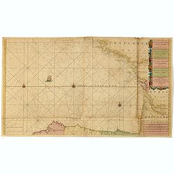
A Correct Chart Of The Sea Coasts Of England, Flanders And Holland Shewing The Sands Shoals Rocks And Dangers, The Bays Harbours Roads Buoys Beacons & Seamarks On The Said Coasts.
Mount & Page's chart of the Channel and contiguous British, Belgian and Dutch Coastlines. The imprint of "W.& J.Mount & T.Page" helps date this part...
Date: London, ca. 1750
Selling price: ????
Please login to see price!
Sold in 2020
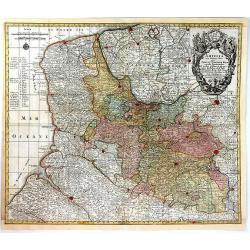
Poloniae Regnum ut et Magni Ducatus Lithuaniae . . .
Detailed map of Poland and the Baltic regions, extending in the south to Ukraine and northern Hungary.Matthaus Seutter the elder first published his "Atlas Geographi...
Date: Augsburg, 1740-1750
Selling price: ????
Please login to see price!
Sold in 2020
Carte de la Tartarie Orientale. . .
A detailed copper engraved map of northeast Asia and Manchuria, showing the island "Sagallan Anga Hata" or "Isle de Bouche Noire". From Prevost's &quo...
Date: Paris, 1750
Selling price: ????
Please login to see price!
Sold in 2021
![[An untitled Sea Chart of South Devon.]](/uploads/cache/46633-250x250.jpg)
[An untitled Sea Chart of South Devon.]
A large scale English Sea Chart of part of southern Devon in SW England. The chart is dominated by a very decorative dedication cartouche highlighting the landing of Will...
Date: London ca 1750
Selling price: ????
Please login to see price!
Sold in 2020
![Carte Generale Inserviente al Teatro della Guerra [...]a Lusazia, la Silesia divisa. . .](/uploads/cache/84695-250x250.jpg)
Carte Generale Inserviente al Teatro della Guerra [...]a Lusazia, la Silesia divisa. . .
A very rare map of the area around Wroclaw and Glatz, extending until Prague, Dresden, and Olomouc. With a title cartouche showing a small view. Further two putti holding...
Date: Venice, ca 1750
Selling price: ????
Please login to see price!
Sold in 2020
Kaart van de Baay van Cadix met de Palan Fortificatien Ten Dienst der Zeevaart opgesteld door William May...
Scarce chart of the Bay of Cadiz, showing with large details towns, settlements, soundings, anchorages, etc., and an inset of the fortifications. There is a very decorati...
Date: Amsterdam, 1750
Selling price: ????
Please login to see price!
Sold in 2023
A Correct Chart of the Sea Coasts of England, Flanders, and Holland…
Nice example of Mount & Page's map of the Channel showing the coastlines of England, Belgium and Holland.Published at first in 1671-1672 in John Seller's 'The English...
Date: London, ca. 1750
Selling price: ????
Please login to see price!
Sold in 2021
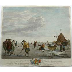
Winter pleasures on the Haarlemmer Lake with Haarlem in the distance.
Engraving By J. Aliamet, Les Amusements De L'Hiver. Rare 18th century Dutch golf engraving by J. Aliamet depicting Dutchman playing the early form of golf on the ice near...
Date: Paris, 1750
Selling price: ????
Please login to see price!
Sold in 2023
Le royaume de Boheme, le Duché de Silésie..
Covering Czech Republic, embellished with decorative title cartouche.
Date: Paris, 1751
Selling price: ????
Please login to see price!
Sold in 2008
Pays-Bas Catholiques.
Nice, detailed, copper engraved map of the region of present day Belgium and Luxembourg. A fine military themed cartouche with a large fancy cartouche. Gilles Robert de V...
Date: Paris, 1751
Selling price: ????
Please login to see price!
Sold in 2015
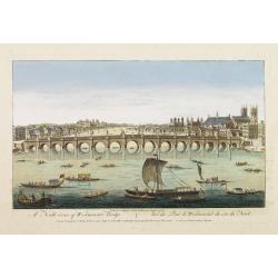
A North viewe of Westminster Bridge.
So-called optical print illustrating a North view of Westminster Bridge with vessels on the River Thames.In the eighteenth and nineteenth centuries there were many popula...
Date: London 1751
Selling price: ????
Please login to see price!
Sold
![Les Ports de, Lisbonne [. . .] Le Detroit de Gibraltar...Cadis](/uploads/cache/90434-250x250.jpg)
Les Ports de, Lisbonne [. . .] Le Detroit de Gibraltar...Cadis
A finely engraved two section map of the Lisbon coast / Setubal area of Portugal and Cadiz / Straights of Gibraltar in Spain. The work contains two elaborate cartouches a...
Date: Paris, ca. 1751
Selling price: ????
Please login to see price!
Sold in 2008
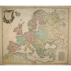
L'Europe divisée en ses principaux Etats?
A detailed map from the Atlas Universel. The map is precisely engraved and not given to the fanciful cartography being promoted by many of the other contemporary French t...
Date: Paris, 1751
Selling price: ????
Please login to see price!
Sold in 2009
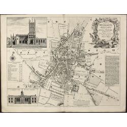
A Plan of Wolverhampton Surveyed in MDCCL By Isaac Taylor and Engraved by Thomas Jefferys Geographer to His Royal Highness the Prince of Wales
Important and rare plan of Wolverhampton by T. JefferysA large and detailed copper engraved plan of Wolverhampton, engraved and published by Thomas Jefferys in 1751 after...
Date: London, 1751
Selling price: ????
Please login to see price!
Sold in 2010
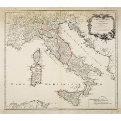
Italia antiqua cum insulius Sicilia, Sardinia et Corsica. . .
Map of Italy, including the islands of Corsica, Sardinia and Sicilia. Published by Robert Vaugondy (son 1723-1886) after a map by Nicolas Sanson.Map shows the ancient div...
Date: Paris, c.1751
Selling price: ????
Please login to see price!
Sold in 2010
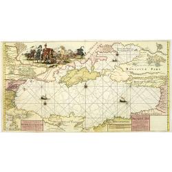
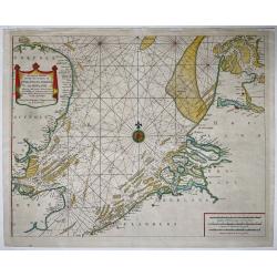
Nieuwe Paskaart van de gehele Swarte Zee Beginnende van Constantinopolen tot Azak opgestelt door G: van Keulen. . .
A highly detailed and rare chart of the Black Sea.A large title cartouche upper left, and a dedication to Peter Alexeowits (the Great).
Date: Amsterdam, 1751
Selling price: ????
Please login to see price!
Sold in 2010
An accurate map of the county Palatine of Durham. . .
Scarce pre-atlas issue of 'The Large English Atlas' map of County Durham, published by John Hinton in 1751. Decorative cartouche around the title. Important and influenti...
Date: London, 1751
Selling price: ????
Please login to see price!
Sold in 2017
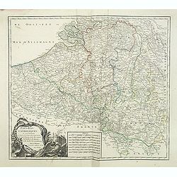
Pays-Bas Catholiques . . .
Detailled map of Belgium from his "Atlas Universel".Gilles Robert de Vaugondy (1688–1766), also known as Le Sieur or Monsieur Robert, and his son, Didier Robe...
Date: Paris, 1751
Selling price: ????
Please login to see price!
Sold in 2011
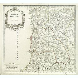
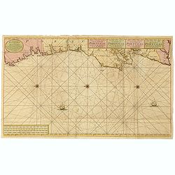
Partie Septentrionale du Royaume de Portugal.
Detailed map encompassing the whole northern half of Portugal from his "Atlas Universel".Gilles Robert de Vaugondy (1688–1766), also known as Le Sieur or Mons...
Date: Paris, 1751
Selling price: ????
Please login to see price!
Sold in 2011
Le Royaume de Hongrie.
Detailed map of Hungary. Including kingdom of Croatia, Bosnia, Serbia and Bulgaria from his "Atlas Universel".Gilles Robert de Vaugondy (1688–1766), also know...
Date: Paris, 1751
Selling price: ????
Please login to see price!
Sold in 2020
Partie Meridionale du Royaume de Portugal.
Detailed map encompassing the whole southern half of Portugal from his "Atlas Universel".Gilles Robert de Vaugondy (1688–1766), also known as Le Sieur or Mons...
Date: Paris, 1751
Selling price: ????
Please login to see price!
Sold in 2011
Charta öfwer Stockholms Stads Belägenhet.
A scarce town-plan of Stockholm. The map was engraved by Georg Biurmans himself and covers a large area around Stockholm including Drottningholm Palace in the west and in...
Date: Stockholm, c.1751
Selling price: ????
Please login to see price!
Sold in 2012
Charta öfwer Stockholm med des malmar och förstäder af Hans Konge Majt. til strandernes anlaggning i nader faststäld den 1. julii 1751.
A scarce town-plan of Stockholm. The map was engraved by Georg Biurmans himself and covers a large area around Stockholm. The major roads are carefully recorded. A large ...
Date: Stockholm, c.1751
Selling price: ????
Please login to see price!
Sold in 2012
Galliae Christianae Belgica Secunda Provinciae Ecclesiasticae Remensis
Nicely detailed copper engraved map covering the southwestern part of France. This map depicts the cities of Amiens, Senlis, Laon, Beauvais and Saint-Omer. Details includ...
Date: Paris, 1751
Selling price: ????
Please login to see price!
Sold in 2014
Galliae Christianae Belgicae Secundae Ecclesiasticae Provinciae Remensis
Very large, decorative title cartouche on an interesting Nolin map of Reims, Amiens & Senlis France. Engraved on copper plates by Dussy.J. B. Nolin 1657-1708)set up h...
Date: Paris, 1751
Selling price: ????
Please login to see price!
Sold in 2014
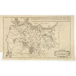
Carte generale des Villes et des Bailliages de la Prusse avec une partie de la Pologne et de la Vistule depuis Fantzig jusque à Warsovie.
Scarce map of northern part of Poland, including Gdansk and Warschaw. Engraved by Jacobus van der Schley (1715 - 1779).From "Memoires Pour Servir A L'Histoire De La ...
Date: The Hague, Berlin, Jean Neaulme, 1751
Selling price: ????
Please login to see price!
Sold in 2013
Duche de Savoye qui comprend le Chablais, le Fossigny, le Genevois, la Savoye Propre, la Tarentaise et la Maurienne, dresse d'apres la Grande Carte de Piemont de Tomaso Borgomo (i.e., Borgonio) et autres. . .
Finely and crisply engraved map of Savoy prepared by Robert de Vaugondy's map, from "Atlas Universel".Large decorative title cartouche in the upper right corner...
Date: Venice, ca.,1751
Selling price: ????
Please login to see price!
Sold
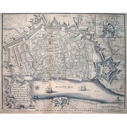
Antwerp A strong, large, and Beautiful City on ye River Scheld, in the Dutchy of Brabant, subject to ye Queen of Hungary / Plan of the City and Citadel of Antwerp
A large and very detailed plan of Antwerp with its forts. Shows numerous buildings and street names! Published in "Mr Tindal's Continuation of Mr Rapin's History of ...
Date: London, 1751
Selling price: ????
Please login to see price!
Sold in 2013
Nieuwe paskaart van het zuyderste gedeelte der Noord-Zee strekkende van Texel tot aande Hoofden...
Fine chart of the North Sea with the coasts of Belgium, Netherlands and South East England. Decorated with soundings, compass card, ship. Full title in a cartouche at bot...
Date: Amsterdam, 1728-1751
Selling price: ????
Please login to see price!
Sold in 2021
Cercle de Westphalie, divisé en tous ses etats et souverainetés.
Detailed map of the northwestern part of Germany, centered on M¨nster.
Date: Paris, 1751
Selling price: ????
Please login to see price!
Sold in 2014
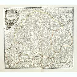
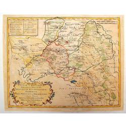
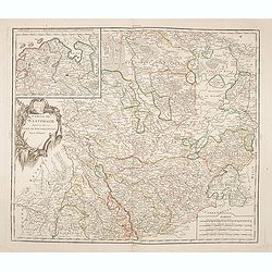
Partie méridionale du cercle de Haute Saxe. . .
Detailed map of part of Germany, centered on Leipzig.
Date: Paris, 1751
Selling price: ????
Please login to see price!
Sold in 2014
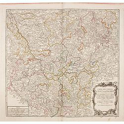
Partie méridionale du cercle de Haute Saxe. . .
Highly detailed regional map from De Vaugondy's Atlas Universel.
Date: Paris, 1751
Selling price: ????
Please login to see price!
Sold in 2014
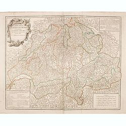
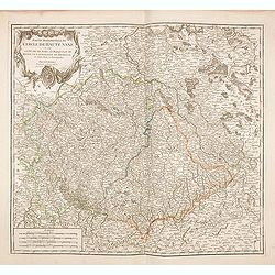
Carte de la République des Suisses. . .
Detailed map of Switzerland from De Vaugondy's Atlas Universel.
Date: Paris, 1751
Selling price: ????
Please login to see price!
Sold in 2014
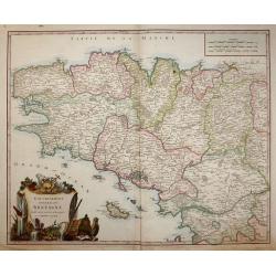
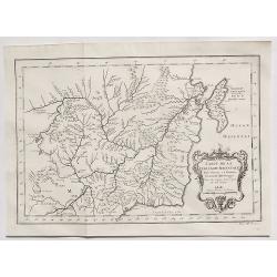
Gouvernement General de Bretagne divife dioceses ou recceptes.
An attractive map of Brittany that extends to the island of Belle-Île, just off of the Quiberon Peninsula. The map shows the divisions of the dioceses and is filled with...
Date: Paris, 1751
Selling price: ????
Please login to see price!
Sold in 2016
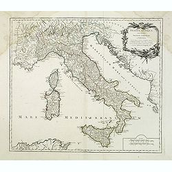
Italia antiqua cum insulius Sicilia, Sardinia et Corsica. . .
Map of Italy, including the islands of Corsica, Sardinia and Sicilia. Published by Robert Vaugondy (son 1723-1886) after a map by Nicolas Sanson. Map shows the ancient di...
Date: Paris, c.1751
Selling price: ????
Please login to see price!
Sold in 2014
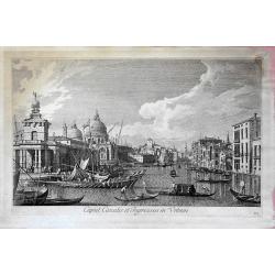
Caput Canalis et ingressus in urbem. . .
From "Urbis Venetiarum prospectus celebriores ex Antonii Canal tabulis XXXVIII. Aere expressi ab Antonio Visentini in partes tres distributi. Pars prima", this ...
Date: Venece, 1751
Selling price: ????
Please login to see price!
Sold in 2018
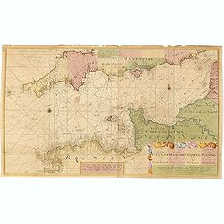
Nieuwe Generale Paskaart van de Bocht van Vrankryk Biscaia en Gallissia tussen I. de Ouessant en C. de Finisterre.
Rare chart of the Gulf of Biscay including all the south-west coast of France from Brest to the south and continuing along the Spanish coast, including Bilbao, until Ferr...
Date: Amsterdam, 1728-1751
Selling price: ????
Please login to see price!
Sold in 2015
Nieuwe Generale Paskaart van de Cust van PORTUGAL tusschen C: de Finisterre. . .
Decorative chart of the coast of Portugal, from Pontevedra (Spain) to the Cape Saint Vincent (Vila do Bispo). East to the top. More about Van Keulen dynasty [+]
Date: Amsterdam, 1751
Selling price: ????
Please login to see price!
Sold in 2015
Nieuwe paskaart van het zuyderste gedeelte der Nord-Zee strekkende van Texel tot aande Hoofden...
Fine chart of the Nord Sea with the coasts of Belgium, Netherlands and South East England. Decorated with soundings, compass card, ship in a title cartouche in four langu...
Date: Amsterdam, 1728-1751
Selling price: ????
Please login to see price!
Sold in 2015
Nieuwe paskaart vande geheele canaal tufschen engeland en vranckryck.
This rare chart shows the Chanel between England et France. With explanation cartouche and ornamentally surrounded title-cartouche, fivefold miles indicator, current arro...
Date: Amsterdam, 1728 - 1751
Selling price: ????
Please login to see price!
Sold in 2016
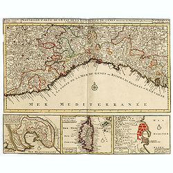
Nouvelle Carte de l'Etat de la Republique de Genes. Dressé sur les mémoires les plus nouveaux. . .
Uncommon map of the Ligurian coast around Genoa in northern Italy with three insets below of the harbors of Genoa and Bastia and the island of Corsica.Joachim Ottens (166...
Date: Amsterdam, 1751
Selling price: ????
Please login to see price!
Sold in 2016
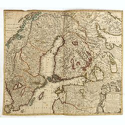
Regni Sueciae Tabula Generalis, divisa in Sueciae, Gotiae.
Fine map centered on Finland, including part of Sweden, Norway and Russia.The map was originally issued by Frederick de Wit but than re-issued by Pieter Mortier in Amster...
Date: Amsterdam, 1751
Selling price: ????
Please login to see price!
Sold in 2018
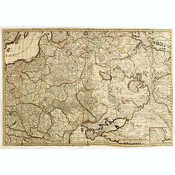
Sades Belli in POLONIA et in Moscovia . . .
Scarce map including Lithuania, Russia, Ukraine, Curlandia, Livonia, Tartaria Minor, Walachia, Volhynia, etc. With a key in lower bottom. Small inset map of Astrakan regi...
Date: Amsterdam, 1751
Selling price: ????
Please login to see price!
Sold in 2015
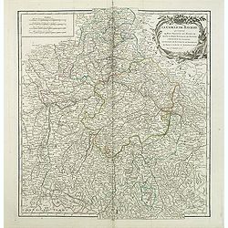
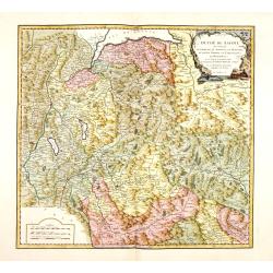
Le cercle de Baviere . . .
Interesting regional map, extending from Waldeck in the North to Efferding on the Danube in the East, Saltzberg and the Tyrolian Alps in the South and Dillingen on the Da...
Date: Paris, 1751
Selling price: ????
Please login to see price!
Sold in 2016
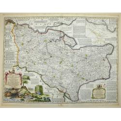
AN ACCURATE MAP OF THE COUNTY OF KENT DIVIDED INTO ITS LATHES, and Subdivided into Hundreds. Drawn from Surveys, and most approved modern Maps, with various additional Improvements: Illustrated with Historical Extracts relative to the Air, Soil, Natural P
A first edition pre Large Atlas. A large and handsome eighteenth-century map of the county on a scale of three-eighths of an inch to the mile.Compiled by Emanuel Bowen, G...
Date: London, 1751
Selling price: ????
Please login to see price!
Sold in 2017
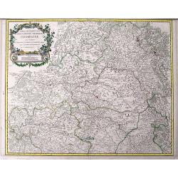
Partie septentrionale du Gouvernem? general de Champagne....
Very detailed map of the northern part of the famous Champagne region, centered on Reims. Includes towns, mountains, rivers, lakes, etc. With a large decorative title car...
Date: Paris, ca. 1751
Selling price: ????
Please login to see price!
Sold in 2016
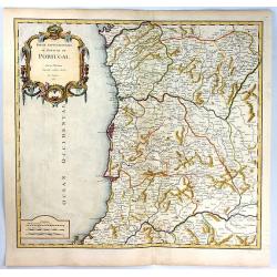
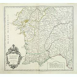
Partie Septentrionale du Royaume de Portugal
A finely engraved map of the northern portion of Portugal by Robert de Vaugondy. It covers northern Portugal from Tui in Spain, southward to Santarem, and inland as far a...
Date: Paris, 1751
Selling price: ????
Please login to see price!
Sold in 2019