Browse Listings in Europe
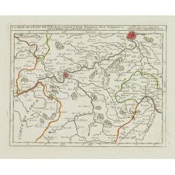
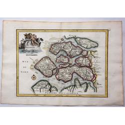
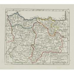
V. Carte de l\'Etat de Lyege.. ou se trouvent Lyege, Hannuye, Huy..
Attractive small map showing part of the Wallon region, south west of Liège. Dated 1748. From Atlas Portatif Universel, by Robert de Vaugondy.Page 15e outside border top...
Date: Paris, 1748
Selling price: ????
Please login to see price!
Sold in 2008
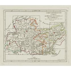
Carte Générale des Comtés de Haynaut, de Namur, et de Cambresis.
Attractive small map encompassing an area straddling the border between Belgium and France.Showing Cambrai, Tournai, Mons and Namur. Divided into 10 sections. From Atlas ...
Date: Paris, after 1748
Selling price: ????
Please login to see price!
Sold in 2008
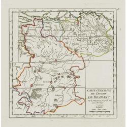
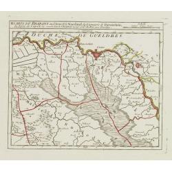
Carte Generale du Duché de Brabant.
Nice small map illustrating the Duchy of Brabant in the Low Countries. Divided into 10 sections. Centered on Herentals.The historical region consisted not only of the thr...
Date: Paris, later than 1748
Selling price: ????
Please login to see price!
Sold
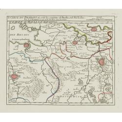
II. Carte du Brabant où sont les environs de Bréda, et de Bosleduc.
Nice small map illustrating part of North Brabant. Extending West to East from Breda to ?s-Hertogenbosch.From Atlas Portatif Universel, by Robert de Vaugondy. Unrecorded ...
Date: Paris, later than 1748
Selling price: ????
Please login to see price!
Sold
III. Carte du Brabant ou se trouvet le Maesland, la Seigneurie de Ravenstein, la Terre de Cuyck &c.
Nice small map illustrating a stretch of the river Meuse, flowing besides Alphen, Grave and Gennep.From Atlas Portatif Universel, by Robert de Vaugondy. Unrecorded state ...
Date: Paris, later than 1748
Selling price: ????
Please login to see price!
Sold
![[IV.] Carte du Brabant où se trouvét la Mairie de Santhoven.. Ryen.](/uploads/cache/24684-250x250.jpg)
[IV.] Carte du Brabant où se trouvét la Mairie de Santhoven.. Ryen.
Nice small map encompassing an area which straddles the border between Belgium and the Netherlands.Showing Antwerp in the central lower part. From Atlas Portatif Universe...
Date: Paris, later than 1748
Selling price: ????
Please login to see price!
Sold in 2008
VI. Carte du Brabant ou se trouv.t les envir.s d'Eyndhoven..
Nice small map illustrating part of southeastern Noord Brabant. With Eindhoven and Helmond in center of map.From Atlas Portatif Universel, by Robert de Vaugondy. Unrecord...
Date: Paris, later than 1748
Selling price: ????
Please login to see price!
Sold
VII. Carte du Brabant ou sont les environs de Bruxelles, de Malines et Liere.
Nice small map illustrating part of the Flemish region and the Brussels-Capital Region. It shows Brussels, Aalst, Dendermonde, Mechelen and Lier.From Atlas Portatif Unive...
Date: Paris, later than 1748
Selling price: ????
Please login to see price!
Sold
![[VIII.] Carte du Brabant ou sont les env.s de Louvain, d'Ascot, de Diest de Leeuwe &c.](/uploads/cache/24688-250x250.jpg)
[VIII.] Carte du Brabant ou sont les env.s de Louvain, d'Ascot, de Diest de Leeuwe &c.
Nice small map illustrating part of the Flemish region. It shows Leuven, Aarschot, Diest and Sint-Truiden.From Atlas Portatif Universel, by Robert de Vaugondy. Unrecorded...
Date: Paris, later than 1748
Selling price: ????
Please login to see price!
Sold in 2022
![[III]. Carte de l'Etât de Gênes où se trouvent la Principauté d'Oneille, les enviros d'Albinga, le Marquisat de Finale &c.](/uploads/cache/24546-250x250.jpg)
[III]. Carte de l'Etât de Gênes où se trouvent la Principauté d'Oneille, les enviros d'Albinga, le Marquisat de Finale &c.
Detailed small map showing the Ligurian seacoast stretching from Oneglia as far as Vado Ligure.Relief shown pictorially. From Atlas Portatif Universel, by Robert de Vaugo...
Date: Paris, later than 1748
Selling price: ????
Please login to see price!
Sold in 2013
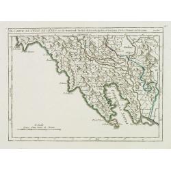
IV. Carte de l'Etât de Gênes ou se trouvent les environs de Savone..
Detailed small map showing an area straddling the Piedmontese province of Cuneo and the Ligurian province of Savona.Relief shown pictorially. From Atlas Portatif Universe...
Date: Paris, later than 1748
Selling price: ????
Please login to see price!
Sold in 2013
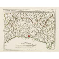
V. Carte des Environs de Genes..
Detailed small map centered on Genoa. With Portofino in the lower right corner. Relief shown pictorially.From Atlas Portatif Universel, by Robert de Vaugondy.Page 56.e ou...
Date: Paris, later than 1748
Selling price: ????
Please login to see price!
Sold in 2017
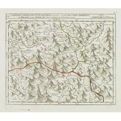
VII. Carte des Confins de l'Etât de Gênes.. Milanez et du Parmesan.
Detailed small map showing an area straddling the provinces of Alessandria, Pavia and Piacenza on 3 different regions.Relief shown pictorially. From Atlas Portatif Univer...
Date: Paris, later than 1748
Selling price: ????
Please login to see price!
Sold in 2014
IX. Carte de l'Etât de Gênes ou se trouvent Sestri-di Levante, Spetia et Sarzana.
Detailed small map showing the east most tip of Liguria. Relief shown pictorially.From Atlas Portatif Universel, by Robert de Vaugondy.Page 56.i outside border top right....
Date: Paris, later than 1748
Selling price: ????
Please login to see price!
Sold in 2008
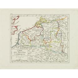
Carte des Pays-Bas Catholiques.
Nice small map that extends from Dieppe to Verdun and north into Holland. Dated 1748.From Atlas Portatif Universel, by Robert de Vaugondy.
Date: Paris, 1748
Selling price: ????
Please login to see price!
Sold in 2008
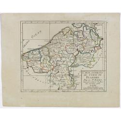
I. Carte du Comté de Flandre où sont les env.s de l'Ecluse, d'Ardenburg.. &c.
Nice small map illustrating the southwestern most part of Zeeland. Centered on Sluis. Showing Aardenburg and Vlissingen. Dated 1768.From Atlas Portatif Universel, by Robe...
Date: Paris, later than 1748
Selling price: ????
Please login to see price!
Sold in 2008
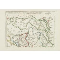
II. Carte de la Flandre où sont les environs d'Axel, d'Hulst..
Nice small map illustrating the southeastern part of Zeeland. Showing Middelburg, Goes, Tholen, Bergen op Zoom, Hulst and Axel.From Atlas Portatif Universel, by Robert de...
Date: Paris, later than 1748
Selling price: ????
Please login to see price!
Sold in 2008
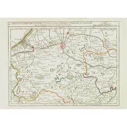
IV. Carte du Comté de Flandre où sont les environs de Bruges, d'Ostende, de Dixmunde.
Nice small map covering part of the West Flanders, delimited by Oostende, Bruges, Tielt, Roeselare and Diksmuide.From Atlas Portatif Universel, by Robert de Vaugondy. Unr...
Date: Paris, later than 1748
Selling price: ????
Please login to see price!
Sold in 2008
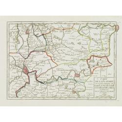
V. Carte de la Flandre où sont les environs de Gand.. et d'Anvers.
Charming small map covering part of the East Flanders, delimited by Ghent, Sas van Gent, Aalst, and Antwerp.From Atlas Portatif Universel, by Robert de Vaugondy. Unrecord...
Date: Paris, later than 1748
Selling price: ????
Please login to see price!
Sold in 2008
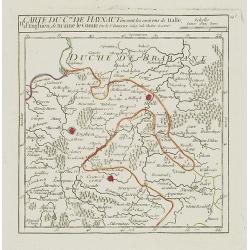
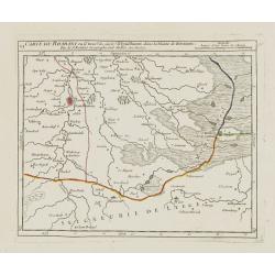
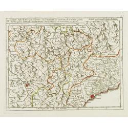
II. Carte du C.té de Haynaut où sont les environs de Halle, d'Enghien, de Braine le Comte.
Attractive small map encompassing part of Hainaut. It shows the towns of Enghien, Halle and Braine-le-Comte.From Atlas Portatif Universel, by Robert de Vaugondy.Unrecorde...
Date: Paris, after 1748
Selling price: ????
Please login to see price!
Sold in 2015
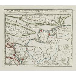
I. Carte du Brabant où sont les environs de Berg-op-zoom, de Tolen dans la Zélande. et de Willemstat dans la Hollande.
Nice small map centered on the western part of North Brabant. It shows Bergen op Zoom, Tholen, Willemstad, Klundert, etc.From Atlas Portatif Universel, by Robert de Vaugo...
Date: Paris, later than 1748
Selling price: ????
Please login to see price!
Sold in 2012
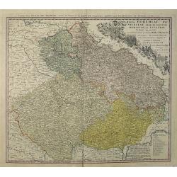
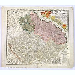
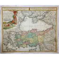
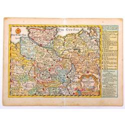
Regni Bohemiae, Duc. Silesiae, Marchionatuum Moraviae et Lusatiae. . .
Johann Baptist Homann's well-engraved map including the towns of Prague, Poznan/ Loda, Wroclaw, etc.Johann Baptist Homann (1663-1724) was a German engraver and publisher,...
Date: Nuremberg, 1748
Selling price: ????
Please login to see price!
Sold in 2013
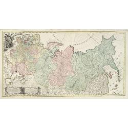
Carte générale de l'empire de Russie.
According to the description panel in lower left : the map covers the Empire of Peter the Great.This important is based on maps from the Bering expedition and on De L'Isl...
Date: Amsterdam, ca.1748
Selling price: ????
Please login to see price!
Sold in 2009
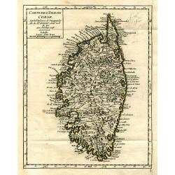
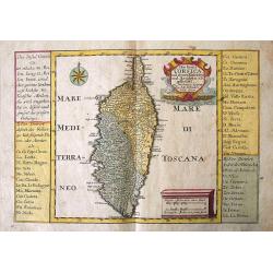
Carte de l'Isle de Corse.
Charming and very detailed map of Corsica. Shows towns, rivers, lakes, woods, mountains, bays, and islands.
Date: Paris, 1748
Selling price: ????
Please login to see price!
Sold in 2010
Regni Bohemiae, Duc. Silesiae, Marchionatuum Moraviae et Lusatiae. . .
Johann Baptist Homann's well-engraved map including the towns of Prague, Poznan/ Loda, Wroclaw, etc.Johann Baptist Homann (1663-1724) was a German engraver and publisher,...
Date: Nuremberg, 1748
Selling price: ????
Please login to see price!
Sold in 2010
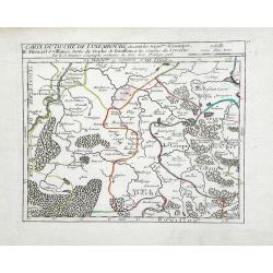
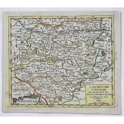
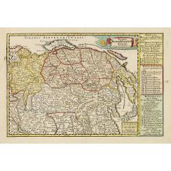
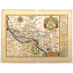
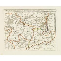
Carte du Duche de Luxembourg ou sont les Seign de Lompre, IV Mirwart et Villance, Partied u Duche de Bouillon, et les Consins du Lyegeois
Small scale map of region of the Duchy of Luxembourg, a former principality of the Holy Roman Empire, showing the region of southern Belgium by Robert de Vaugondy. Gilles...
Date: Paris, 1748
Selling price: ????
Please login to see price!
Sold in 2010
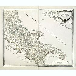
Partie septentrionale du Royaume de Naples.
Map of the southern part of Italy with Naples from his "Atlas Universel".Gilles Robert de Vaugondy (1688–1766), also known as Le Sieur or Monsieur Robert, and...
Date: Paris, 1748
Selling price: ????
Please login to see price!
Sold
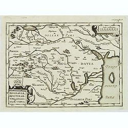
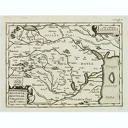
Moldaviae, finitimar umo regionum typus.
Uncommon map of Moldavia published in the second edition of Martinus Broniovius "Tartariae description ..." His work appeared first in 1595. The second edition ...
Date: Vienna, 1746-1748
Selling price: ????
Please login to see price!
Sold in 2012
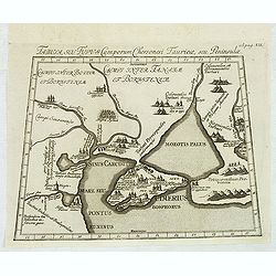
Tabula, seu Typus Camporum Chersonesi . . .
Rare map of part of the Ukraine and the Black Sea region, published in the second edition of Martinus Broniovius "Tartariae description ..."
Date: Vienna, 1746-1748
Selling price: ????
Please login to see price!
Sold in 2012
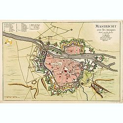
Mastricht avec les Attaques Leve sur les Lieux en Juin 1748. A Paris chez Le Sr. Le Rouge.
A rare separate published plan of Maastricht by G. L. le Rouge. Showing the fortified city with important buildings named. With a key from A to X, a mileage scale and a c...
Date: Paris, 1748
Selling price: ????
Please login to see price!
Sold
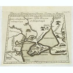
Tabula, seu Typus Camporum Chersonesi Tauricae, seu Peninsulae.
Rare map of part of the Ukraine and the Black Sea region, published in the second edition of Martinus Broniovius "Tartariae description ..." His work appeared f...
Date: Vienna, 1746-1748
Selling price: ????
Please login to see price!
Sold in 2013
Moldaviae, finitimar umo regionum typus.
Uncommon map of Moldavia published in the second edition of Martinus Broniovius "Tartariae description ..." His work appeared first in 1595. The second edition ...
Date: Vienna, 1746-1748
Selling price: ????
Please login to see price!
Sold
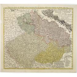
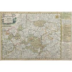
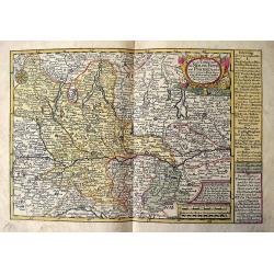
Partie Meridionale du Cercle de Haute Saxe.
Large detailed copper engraved map of the Duchies of Saxe & Meissen in Germany. Features cities such as Prague, Leipzig, Dresden, Berlin & Wittenberg.Johann Bapti...
Date: Nuremberg, 1748
Selling price: ????
Please login to see price!
Sold in 2013

Sir Richard Steele.
This ia a large finely engraved portrait of Sir Richard Steele, the private secretary to James. the 1st Duke of Ormonde. It was engraved by Houbraken from a painting by K...
Date: Amsterdam, 1748
Selling price: ????
Please login to see price!
Sold in 2016
Regni Bohemiae, Duc. Silesiae, Marchionatuum Moraviae et Lusatiae. . .
Johann Baptist Homann's well-engraved map including the towns of Prague, Poznan/ Loda, Wroclaw, etc.This example was printed from plate B (2nd of 3), which can be identif...
Date: Nuremberg, 1748
Selling price: ????
Please login to see price!
Sold in 2018
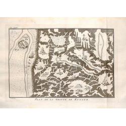
Plan de la Grotte de Kungur.
Interesting map of the Kungeron fortress in Krai Russia in the Ural Mountains. This is the site of the Kungur ice cave.Published in Prevost's "L'Histoire Generale de...
Date: The Hague, 1748
Selling price: ????
Please login to see price!
Sold in 2016
Zelande.
Hand colored copperplate map of the Dutch province of Zeeland by le Rouge from his “Atlas Nouveau Portatif “. Features cartouche of a putti holding a coat of arms and...
Date: Paris, 1748
Selling price: ????
Please login to see price!
Sold in 2017
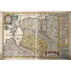
La Basse Autriche.
Fine detailed map of lower Austria by Le Rouge. Features a cartouche depicting a battle between soldiers.George Louis Le Rouge was active from 1740- till 1780 as a publis...
Date: Paris, 1748
Selling price: ????
Please login to see price!
Sold in 2018
Regni Bohemiae, Duc. Silesiae, Marchionatuum Moraviae et Lusatiae. . .
Johann Baptist Homann's well-engraved map including the towns of Prague, Poznan/ Loda, Wroclaw, etc.Johann Baptist Homann (1663-1724) was a German engraver and publisher,...
Date: Nuremberg, 1748
Selling price: ????
Please login to see price!
Sold in 2018
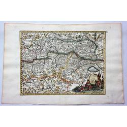
L'Archiduche D'Autriche et les Duches de Stirie, Cartinthie et Carniole.
A fine map of Inner Austria, or currently Austria, Slovenia and Hungary. This region referred to the Duchies and Habsburg hereditary lands. It was published in the 1748 e...
Date: Paris, 1748
Selling price: ????
Please login to see price!
Sold in 2017
Carte de l'Asie Minevre. . .
A striking map centred on the Black Sea, and the geographical regions surrounding it. Map also shows Asia Minor, Crete, Cyprus, northern Syria, Iraq, Georgia, the Crimea,...
Date: Nuremburg, 1748
Selling price: ????
Please login to see price!
Sold in 2018
Regni Bohemiae, Duc. Silesiae, Marchionatuum Moraviae et Lusatiae. . .
Johann Baptist Homann's well-engraved map including the towns of Prague, Poznan/ Loda, Wroclaw, etc.Johann Baptist Homann (1663-1724) was a German engraver and publisher,...
Date: Nuremberg, 1748
Selling price: ????
Please login to see price!
Sold in 2020
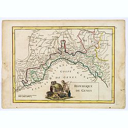
Republique de Genes.
A nice map of northwest Italy and the Gulf of Genoa, at left Nice and Monaco, there is a nice putti-scene in the sea, reflecting Genoese exploration and discovery around ...
Date: Paris, 1748
Selling price: ????
Please login to see price!
Sold in 2019
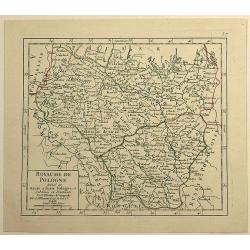
Royaume de Pologne Divisee en Haute et Basse Pologne ...
Fine example of De Vaugondy's map of the Kindgom of Poland, from his “Atlas Portatif. . . ,” first published in Paris in 1748.Gilles Robert de Vaugondy (1688–1766),...
Date: Paris, 1748
Selling price: ????
Please login to see price!
Sold in 2019
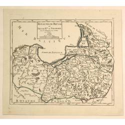
Royaume de Prusse et Prusse Rle. ou Ponolaise.
This is a pleasing map of Prussia by Robert de Vaugondy. It covers the northeastern part of Poland and extends from Grodno and the Spirding-See in Poland north to Klaiped...
Date: Paris, 1748
Selling price: ????
Please login to see price!
Sold in 2019
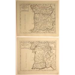
Partie Meridionale (and Septentrionale) du Royaume de Portugal. (2 Maps)
Two small detailed maps encompassing the whole of Portugal. From Atlas Portatif Universel, by Vaugondy. Numbered plate 50 and 51 in the top right corner. Gilles Robert ...
Date: Paris, 1748
Selling price: ????
Please login to see price!
Sold in 2020
![[2 prints] The inside perspective view of the under Chappel... / A view of the west front of the Chappel...](/uploads/cache/82580-250x250.jpg)
[2 prints] The inside perspective view of the under Chappel... / A view of the west front of the Chappel...
Two quite rare attractive copper-engravings of the St. Thomas Chapel on the old London Bridge. Engraved by James Basire, drawn by George Vertue, published in the first vo...
Date: London, 1748
Selling price: ????
Please login to see price!
Sold in 2019
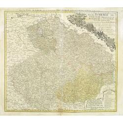
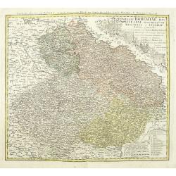
Royaume de Boheme, Marqui de Moravie et Silesie Autrichienne.
A fine 1748 map of Bohemia, Moravia and Silesia by Robert de Vaugondy. It covers modern day Czech Republic as well as parts of Germany and Poland. It extends from Leipzig...
Date: Paris, 1748
Selling price: ????
Please login to see price!
Sold in 2019
![[Lot of 3 maps] Pontus Euxinus anders Mare Maggiore](/uploads/cache/IMG_3162-250x250.jpg)
[Lot of 3 maps] Pontus Euxinus anders Mare Maggiore
[ Lot of 3 maps ]- De Beschryvingh van de Reysen Pauli, en van de Andere Apostelen (1702). - M. Heberers Ongelukkige Voyagie gedaan in Verscheyde gedeeltens van Asia en...
Date: 1748
Selling price: ????
Please login to see price!
Sold in 2023
Insula Creta hodie Candia.
Johann Baptist Homann's well-engraved map has a large decorative cartouche. Detailed map of Crete.Johann Baptist Homann (1663-1724) was a German engraver and publisher, w...
Date: Nuremberg 1749
Selling price: ????
Please login to see price!
Sold
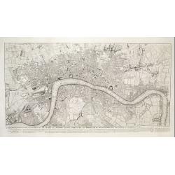
This plan of the cities of London and Westminster and Borough of Southwark, with the contiguous buildings..
First state of this detailed and important plan of London, engraved by Isaac Basire. With a dedication to Martin Folkes.
Date: London, 1749
Selling price: ????
Please login to see price!
Sold
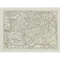
Partie Sept.le des Etats de Castille où se trouvent les Roy.mes des Asturies.. Biscaye.
Small detailed map of Northwestern Spain, including Asturias, León, Old Castille, New Castille and Biscaya. Extends southwards as far as Madrid.From Atlas Portatif Unive...
Date: Paris, later than 1749
Selling price: ????
Please login to see price!
Sold in 2023
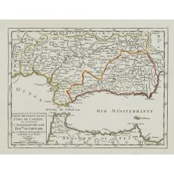
Partie Meridionale des Etats de Castille où se trouvent l'Andalousie et le Roy.me de Grenade.
Small detailed map of Andalusia. From Atlas Portatif Universel, by Robert de Vaugondy.Page 47 outside border top left. Mary Sponberg Pedley does not mention a state witho...
Date: Paris, later than 1749
Selling price: ????
Please login to see price!
Sold in 2017
Partie Meridion.le des Etats de Castille, où se trouvent l'Estremadure-de-Leon et la Castille Nouvelle.
Small detailed map of Extremadura and New Castile. From Atlas Portatif Universel, by Robert de Vaugondy.Page 45 outside border top left. Mary Sponberg Pedley does not men...
Date: Paris, later than 1749
Selling price: ????
Please login to see price!
Sold in 2011
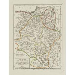
Royaume de Navarre divisé en six Mérindades.
Small detailed map of Navarre. From Atlas Portatif Universel, by Robert de Vaugondy.Page 46 outside border top right. Mary Sponberg Pedley does not mention a state withou...
Date: Paris, later than 1749
Selling price: ????
Please login to see price!
Sold in 2010
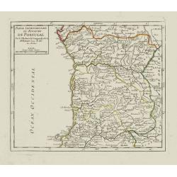
Partie Septentrionale du Royaume de Portugal.
Small detailed map encompassing the whole northern half of Portugal. From Atlas Portatif Universel, by Robert de Vaugondy.Page 50 outside border top right. Mary Sponberg ...
Date: Paris, later than 1749
Selling price: ????
Please login to see price!
Sold in 2012
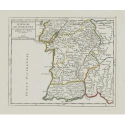
Partie Meridionale du Royaume de Portugal.
Small detailed map encompassing the whole southern half of Portugal. From Atlas Portatif Universel, by Robert de Vaugondy.Page 51 outside border top right. Mary Sponberg ...
Date: Paris, later than 1749
Selling price: ????
Please login to see price!
Sold in 2012
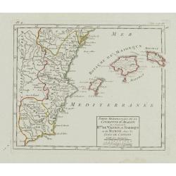
Partie Méridionale de la Couronne d'Aragon.. R.mes de Valence, de Maiorque et de Murcie..
RARE. Small detailed map encompassing the Valencian Community, the region of Murcia and the Balearic Islands.From Atlas Portatif Universel, by Robert de Vaugondy. Page 4 ...
Date: Paris, later than 1749
Selling price: ????
Please login to see price!
Sold in 2010
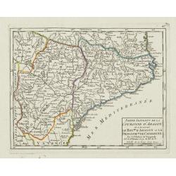
Partie Septent.le de la Couronne d'Aragon où se trouvent le Roy.me d'Aragon.. Catalogne.
Small detailed map of Aragon and Catalonia. From Atlas Portatif Universel, by Robert de Vaugondy.Page 47 outside border top left. Mary Sponberg Pedley does not mention a ...
Date: Paris, later than 1749
Selling price: ????
Please login to see price!
Sold
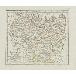
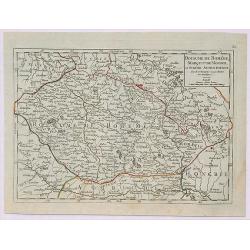
Royaume de Pologne divisé en Haute et Basse Pologne..
Small detailed map showing the southern part of Poland. From Atlas Portatif Universel, by Robert de Vaugondy.Unrecorded state with erased date. Page 37 outside border top...
Date: Paris, later than 1749
Selling price: ????
Please login to see price!
Sold in 2017
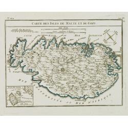
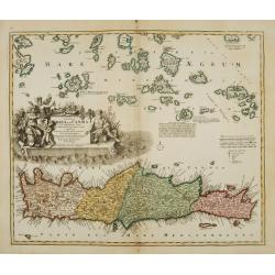
Carte des Isles de Malte et de Goze.
Detailed small map of Malta, with a compass rose in the upper right corner and an inset map of Gozo in the lower left. From Atlas Portatif Universel, by Robert de Vaugond...
Date: Paris, later than 1749
Selling price: ????
Please login to see price!
Sold in 2008
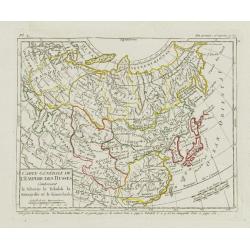
Carte Générale de l'Empire des Russes Contenant la Siberie.. le Kamtchatka.
Small detailed map of Russia. Extending southwards and eastwards to show Korea, Japan, Mongolia and part of China. The title has been reworked from the plate described by...
Date: Paris, later than 1749
Selling price: ????
Please login to see price!
Sold
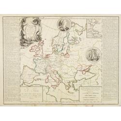
Théatre historique géographique et chronologique du règne de Louis XV Dit le Bien-Aimé. Dedié et présenté au Roy. . .
Uncommon issue of this decorative map showing the Empire of Louis XV (1715-1774). In upper right corner an inset map of the east coast of America, indicating the French p...
Date: Paris, 1749
Selling price: ????
Please login to see price!
Sold in 2008
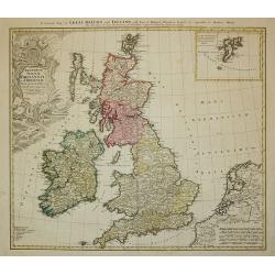
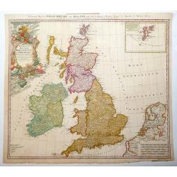
Regnorum Magnae Britanniae et Hiberniae ...
A General Map of Great Britain and Ireland with Part of Holland, Flanders and France.
Date: Nuremberg, 1749
Selling price: ????
Please login to see price!
Sold in 2011
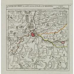
II. Cours du Rhin ou sont les environs de Basle, et de Rhinfelden.
Small detailed map illustrating the stretch of the Rhine which flows between Basel and Rheinfelden.From Atlas Portatif Universel, by Robert de Vaugondy.Unrecorded state w...
Date: Paris, later than 1749
Selling price: ????
Please login to see price!
Sold in 2021
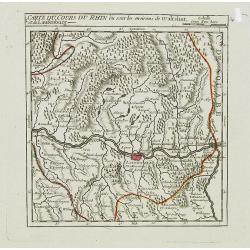
I. Carte du Cours du Rhin où sont les environs de Waltshut, et de Laufenburg.
Small detailed map centered on Laufenburg, illustrating the first stretch of the Rhine which flows between Germany and Switzerland.From Atlas Portatif Universel, by Rober...
Date: Paris, later than 1749
Selling price: ????
Please login to see price!
Sold in 2013
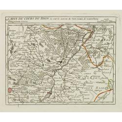
VI. Carte du Cours du Rhin où sont les environs du Fort, Louis, de Lauterburg d'Haguenau.
Small detailed map illustrating the stretch of the Rhine which flows between Fort-Louis and Hochstetten.From Atlas Portatif Universel, by Robert de Vaugondy.Unrecorded st...
Date: Paris, later than 1749
Selling price: ????
Please login to see price!
Sold in 2019
Das gantze Russische Kaeyserthum mit allen seinen Laendern verfertiget von J. G. Schreibern in Leipzig.
Small scale map of Russia by J. G. Schreiber, from his "Atlas Selectus" from 1749, first published in 1740. Showing the area between Reval; Novaja Semlja; Japan...
Date: Leipzig, 1749
Selling price: ????
Please login to see price!
Sold in 2014
Regnorum Magnae Britanniae et Hiberniae.
Issued over a long period by the heirs of Johann Baptist Homann. This handsome map of the British Isles includes very good detail of Ireland, England, Scotland, Wales, an...
Date: Nuremberg, 1749
Selling price: ????
Please login to see price!
Sold in 2013
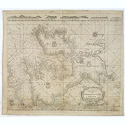
A New and Correct Chart of the Sea Coast of ENGLAND SCOTLAND & IRELAND Sold by George Grierson at the Two Bibles & Kings Arms in Essex Street Dublin
Scarce chart of England, Scotland and Ireland, engraved by James Barlow and published by George Gierson in Dublin. It is copied from Samuel Thornton's chart, 1708, for an...
Date: Dublin, 1749
Selling price: ????
Please login to see price!
Sold in 2012
Der Fraenckishe Creis.
Der Fraenckishe Creis by Johann George Schreiber. The map is high in detail the cartouche is surrounded by two cherubs. From Schreiber's "Atlas Selectus". E...
Date: Leipzig, 1749
Selling price: ????
Please login to see price!
Sold in 2014
Das Aml Gommern und Die Graffschassl Barby Zu Fiden Bey.
Striking detailed map of Gommern and the Elbe River in Germany. It has two fancy cartuches, one with two children playing, and a interesting detailed compass rose. The to...
Date: Leipsig, 1749
Selling price: ????
Please login to see price!
Sold in 2015
Reise Charte Durch Nieder Sachen
Nicely detailed map of Lower Saxony from "Atlas Selectus". On the right are explanations of political situations. Johann Georg Schreiber (1676 – 1745), a Ger...
Date: Leipzig, 1749
Selling price: ????
Please login to see price!
Sold in 2014
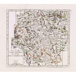
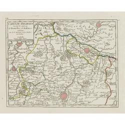
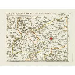
Carte Générale du Duché de Luxembourg.
Charming small map representing the Duchy of Luxembourg. Centered on Bastogne. Divided into 11 sections.From Atlas Portatif Universel, by Robert de Vaugondy. Edited by : ...
Date: Paris, later than 1749
Selling price: ????
Please login to see price!
Sold in 2013
VI. Carte du D.ché de Luxembourg.. Seigneurie de Pruym.
Charming small map representing part of Rhineland-Palatinate, close to the border with Luxembourg.From Atlas Portatif Universel, by Robert de Vaugondy. Edited by : "...
Date: Paris, later than 1749
Selling price: ????
Please login to see price!
Sold in 2013
VIII. Carte du D.ché de Luxembourg.. Environs d'Arlon.
Charming small map representing part of Luxembourg, the southernmost province of Wallonia and of Belgium. Centered on Arlon.From Atlas Portatif Universel, by Robert de Va...
Date: Paris, later than 1749
Selling price: ????
Please login to see price!
Sold in 2020
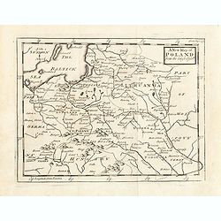
A New map of Poland from the lastest observe.
Map of Poland, Lithuania. Uncolored copper-engraved map, printed in 1749. No cartographer's name was given, possibly by Senex. Shows the Polish kingdom (including Lithuan...
Date: London, 1749
Selling price: ????
Please login to see price!
Sold in 2015
Die Hertzogthümer Curland und Liefland...
Unusual map of the Baltic area which nowadays is mainly covered by Latvia and Estonia. Extends from Libau to St. Petersburg in Russia, including Riga, Revel (Tallinn), Na...
Date: Leipzig, 1749
Selling price: ????
Please login to see price!
Sold in 2016
Die Insul Corsica mit dessen Disricten und Aemtern abgetheilet.
A very detailed map of the island of Corsica. Filled with place names, rivers, and hills. Embellished with the title cartouche, a distance scale, and a compass rose. To t...
Date: Leipzig, 1749
Selling price: ????
Please login to see price!
Sold in 2016
Das meiste von der Lombardey als Meyland, Parma und Piacenza...
Rare map of Lombardy, Piemont, Aosta, Liguria, and Ticino in Switzerland. With the Lago Maggiore, Lago di Como, Lago di Garda, Lago d'Iseo. Extends from Torino to Verona,...
Date: Leipzig, 1749
Selling price: ????
Please login to see price!
Sold in 2017